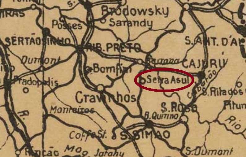
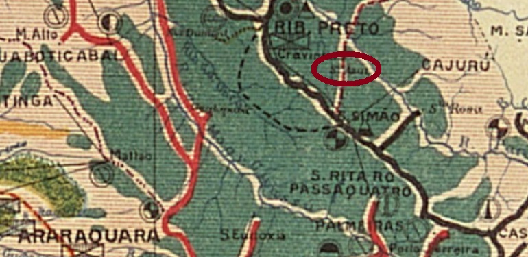
This locality was a freguesia of São Simão from March 1885, located 300 km north of the provincial capital São Paulo. Since November 1927, the locality has been an independent município.
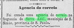
The local post office was created in January 1887, according to the regional press:
Correio Paulistano, 20.01.1887
The Serra Azul station was inaugurated in August 1888 by the Companhia Mogyana (main line) and remained in operation until 1964. However, in 1902 the name of the station changed to Canaã, probably to avoid confusion with another Serra Azul station built in 1893 by the Cia. Melhoramentos de S. Simão railway company (estacoesferroviarias.com.br).
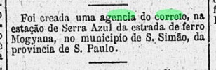
It is likely that the local post office moved after the first Serra Azul station was in operation, because as early as November 1888, the Rio press reported the creation of a station post office:
Gazeta de Noticias/RJ, 21/11/1888
A 19th century postmark was found: SSP-1365b (Coll. Mario Orsi Jr.) is a plain double circle with the inscriptions SERRA AZUL above and (S. PAULO) below. The only specimen so far bears a date from 1897 in the centre.
Estado de S. Paulo, 1910
Diese Ortschaft war ab März 1885 eine Freguesia von São Simão, die 300 km nördlich der Provinzhauptstadt São Paulo entfernt lag. Seit November 1927 ist der Ort ein selbständiger Município.
Das örtliche Postamt entstand im Januar 1887, wie die Regionalpresse berichtet:
Correio Paulistano, 20.01.1887
Der Bahnhof Serra Azul wurde im August 1888 durch die Companhia Mogyana (Hauptlinie) eingeweiht und blieb in Betrieb bis 1964. Allerdings wechselte 1902 der Name des Bahnhofs zu Canaã, wohl um Verwechslungen mit einem andren Bahnhof Serra Azul zu vermeiden, der 1893 von der Cia. Melhoramentos de S. Simão Bahngesellschaft gebaut wurde (estacoesferroviarias.com.br).
Es ist anzunehmen, dass das Ortspostamt umgezogen ist, nachdem der erste Bahnhof Serra Azul in Betrieb war, denn bereits im November 1888 hat die Presse aus Rio die Entstehung eines Bahnhofspostamts gemeldet:
Gazeta de Noticias/RJ, 21.11.1888
Ein Poststempel aus dem 19. Jahrhundert wurde gefunden: SSP-1365b (Samml. Mario Orsi Jr.) ist ein schlichter Doppelkreis mit den Inschriften SERRA AZUL oben und (S. PAULO) unten. Das bisher einzige Exemplar trägt ein Datum aus 1897 in der Mitte.
Est. Ferroviarias do Rio de Janeiro, S. Paulo e Minas Geraes, 1880
Other name: Engenheiro Gurgel (Est.)
This station was inaugurated in 1878 by the E. F. Dom Pedro II Railway Company and was located on the main line (Linha do Centro) in the Município of Vassouras, just under 90 km northwest of the capital Rio de Janeiro. In 1889, the railway operator was renamed E. F. Central do Brasil. The station also got a new name – Engenheiro Gurgel – in about 1940 and belonged to the newly founded Município of Paracambi from 1960. From 1975 until the line was closed in 1996, the railway line was operated by Rede Ferroviária Federal S.A. (estacoesferroviarias.com.br).
There has been a post office there since 1879, as the Rio press reports:
Jornal do Commercio, 11.02.1879
No imperial postmark from this station post office has been found so far.
ca. 1914 (Photo: José E. Buzelin, from estacoesferroviarias.com.br)
Anderer Name: Engenheiro Gurgel (Est.)
Dieser Bahnhof wurde 1878 von der E.F. Dom Pedro II Eisenbahngesellschaft eingeweiht und lag auf der Hauptlinie (Linha do Centro) im Município von Vassouras, knapp 90 km nordwestlich der Hauptstadt Rio de Janeiro entfernt. 1889 wurde die Bahnbetreiberin zu E. F. Central do Brasil umbenannt. Der Bahnhof bekam ca. 1940 auch einen neuen Namen – Engenheiro Gurgel – und gehörte ab 1960 dem neu gegründeten Município von Paracambi. Von 1975 bis zur Streckenstilllegung 1996 wurde die Bahnlinie durch die Rede Ferroviária Federal S.A. betrieben (estacoesferroviarias.com.br).
Ein Postamt gibt es dort seit 1879, wie die Presse aus Rio berichtet:
Jornal do Commercio, 11.02.1879
Bisher wurde kein kaiserlicher Poststempel aus diesem Bahnhofspostamt gefunden.
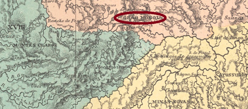
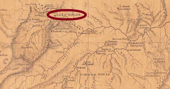
Other names: Serra de Santo Antonio, Serra do Grão-Mogor, Grão Mogol (1840)
See also Grão-Mogol (R. Koester: Carimbologia XX)
This village was already the settlement Serra de Santo Antonio do Itacambirassu in 1781, and was situated on the Ribeirão do Inferno (Hell Creek) near Serro, more than 650 km north of the later provincial capital Ouro Preto. In April 1840, it became the district of Grão Mogol. The name is actually the Portuguese version of Grand Mogol. However, it seems to have less to do with the rulers of northern India from the 16th to the 19th century, and more with the legendary diamond that has been considered lost since 1739. Knowing that diamonds were searched for in the area for centuries, one can understand the dream of such a discovery. Anyway, the local authorities apparently do not like to give information about this subject. In March 1849, Grão Mogol became a villa, and in May 1858, a town.
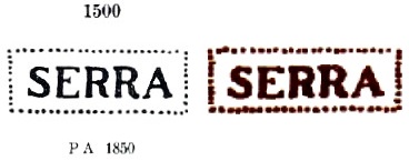
Two creation dates for the local post office were found, almost 50 years apart. Nova Monteiro in Administrações e Agencias Postaes do Brasil Imperio (in Brasil Filatelico/RJ, 1934-5; reprint SPP 1994-1999) writes March 1798, while both Paula Sobrinho (História Postal de Minas Gerais, Belo Horizonte, 1997) and Reinhold Koester (Carimbologia XX) give January 1846. A third date could be added, because in 1833 there was no post office listed in Serra in the Serro county (O Universal, 13 November 1833). And just two years later, we find the postmark SMG-4015a on a letter to Minas Novas:
SMG-4015a (P.A. 1500, RHM P-MG-60)
This stamp also appears in sepia and was already presented by Paulo Ayres under no. 1500 in Catálogo de Carimbos Brasil-Império (S. Paulo, 1937, 1942). However, small differences to the illustration from the RHM catalogue are noticeable.
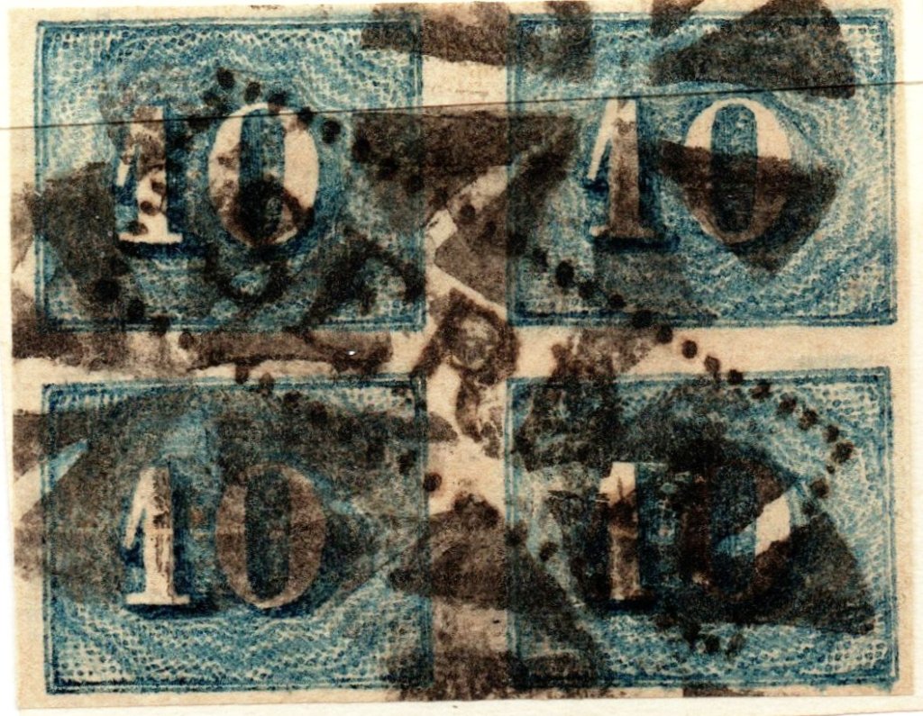
There is also a mute cancellation in connection with SMG-4015a, which was applied on a numeral issue of 1854:
(Coll. José A. Junges)
Since these mute cancellations were not officially ordered before 1865 – and provided that the object above is genuine – this means that SMG-4015 was in use for at least 30 years, and then also 25 years after the place was already called Grão-Mogol. Reinhold Koester (Carimbologia XX) found the first cancel with inscription GRÃO-MOGOR (sic) dated only from 1879 on.
Provincia de Minas Geraes, 1873
Andere Namen: Serra de Santo Antonio, Serra do Grão-Mogor, Grão Mogol (1840)
Siehe auch Grão-Mogol (R. Koester: Carimbologia XX)
Diese Ortschaft war bereits 1781 die Siedlung Serra de Santo Antonio do Itacambirassu, und lag am Ribeirão do Inferno (Höllenbach) bei Serro, über 650 km nördlich der späteren Provinzhauptstadt Ouro Preto entfernt. Im April 1840 wurde daraus der Distrikt von Grão Mogol. Der Name ist tatsächlich die portugiesische Version von Großmogul. Allerdings scheint hier weniger die Rede von den Herrschern in Nordindien vom 16. bis 19. Jahrhundert zu sein, sondern wird eher mit dem legendären Diamanten zu tun haben, der seit 1739 als verschollen gilt. Wenn man weiß, dass in der Gegend jahrhundertlang nach Diamanten gesucht wurde, kann man den Traum von einer solchen Entdeckung nachvollziehen. Wie es dem auch sei, die Behörden vor Ort geben offenbar nicht gerne darüber Auskunft. Im März 1849 wurde Grão Mogol eine Villa, und im Mai 1858 eine Stadt.
Zwei Gründungsdaten fürs örtliche Postamt wurden gefunden, die fast 50 Jahre auseinander liegen. Nova Monteiro schreibt dafür in Administrações e Agencias Postaes do Brasil Imperio (in Brasil Filatelico/RJ, 1934-5; Reprint SPP 1994-1999) den März 1798, während sowohl Paula Sobrinho (História Postal de Minas Gerais, Belo Horizonte, 1997) als auch Reinhold Koester (Carimbologia XX) den Januar 1846 angeben. Es könnte noch ein drittes Datum dazu kommen, denn 1833 war kein Postamt in Serra in der Gemarkung Serro aufgelistet (O Universal, 13. November 1833). Und gleich zwei Jahre später findet man den Poststempel SMG-4015a auf einem Brief nach Minas Novas:
SMG-4015a (P.A. 1500, RHM P-MG-60)
Dieser Stempel kommt auch in sepia vor und wurde bereits durch Paulo Ayres unter Nr. 1500 in Catálogo de Carimbos Brasil-Império (S. Paulo, 1937, 1942) vorgestellt. Allerdings sind kleine Unterschiede zur Abbildung vom RHM-Katalog feststellbar.
Auch in Verbindung zu SMG-4015a ist eine stumme Entwertung vorhanden, die auf eine Ziffer-Ausgabe von 1854 verpasst wurde:
(Samml. José A. Junges)
Da diese stummen Entwertungen erst ab 1865 offiziell angeordnet waren – und wenn das Objekt oben echt ist – bedeutet dies, dass SMG-4015 mindestens 30 Jahre lang verwendet wurde, und dann auch 25 Jahre nachdem der Ort bereits Grão-Mogol hieß. Reinhold Koester (Carimbologia XX) fand den ersten Stempel mit Inschrift GRÃO-MOGOR (sic) erst ab 1879 datiert.
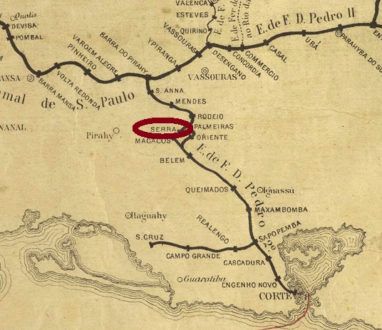
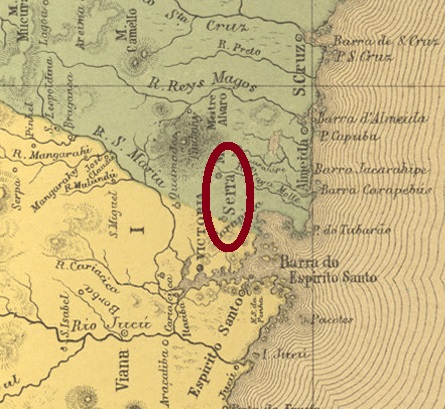
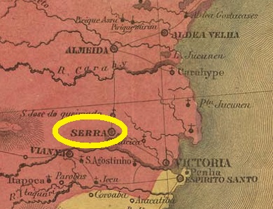
Serra (mountain) was already a freguesia from May 1752, belonging to the later provincial capital Vitória, and 30 km north of it. It became a vila in April 1833 and a town in November 1875.
Here, too, two dates of origin have been found for the local post office. The first one was before March 1847, because then the local postman’s earnings margin was fixed:
Gazeta Official/RJ, 24.03.1847
Paulo Novaes writes “ca. 1856” as the post office creation year in agenciaspostais.com.br. If this information is correct, then the agency was closed in the meantime. Only one postmark from there was found, on the other hand: SES-0180a (Coll. José A. Junges) is a double circle with the inscription CORREIO DA SERRA at the top and an unfortunately poorly legible ornament at the bottom. Found on a D. Pedro issue from 1877.
Villiers de l’Ile Adam: Carta (…) da Provincia do Espirito Santo, 1850
Serra (Gebirge) war bereits ab Mai 1752 eine Freguesia, die zur späteren Provinzhauptstadt Vitória gehörte, und 30 km nördlich davon lag. Im April 1833 wurde der Ort zur Vila und im November 1875 zur Stadt.
Auch hier wurden zwei Entstehungsdaten fürs örtliche Postamt ermittelt. Erstmals vor März 1847, denn zu diesem Zeitpunkt wurde die Verdienstmarge des Postlers vor Ort festgesetzt:
Gazeta Official/RJ, 24.03.1847
Paulo Novaes schreibt als Entstehungsjahr in agenciaspostais.com.br “ca. 1856“. Wenn diese Angabe stimmt, dann war die Agentur zwischendurch geschlossen. Nur ein Poststempel von dort war dagegen gefunden: SES-0180a (Samml. José A. Junges) ist ein Doppelkreis mit der Inschrift CORREIO DA SERRA oben und einem leider schlecht lesbaren Ornament unten. Gefunden auf einer D. Pedro-Ausgabe von 1877.
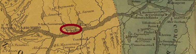
Nossa Senhora do Rosário de Serpa was the name of the villa that is said to have existed as early as 1759 on the north bank of the Amazon River, about 270 km east of the later provincial capital of Manaus. In 1833, the village was demoted to a district of Manaus, but in December 1857, it was again granted villa status. Since April 1874, the locality has been a town called Itacoatiara. The word from the Tupi language means painted stone.
Two opening years were found for the local post office. Nova Monteiro (Administrações e Agencias Postaes do Brasil Imperio, in Brasil Filatelico/RJ, 1934-5; Reprint SPP 1994-1999) writes September 1852 for it, while the Imperial Mail Register (Tabella das Agencias do Correio do Imperio, Rio de Janeiro, 1885) lists this agency from 1855 on. The second date is confirmed by the Rio de Janeiro press:
Jornal do Commercio/RJ, 21.09.1855
Handwritten postal cancellations from Serpa are known, on numeral issues from 1850:
ca. 1855 (Coll. José A. Junges)
In the meantime, however, a previously unknown (and unfortunately also poorly legible) postmark from the Fuad Ferreira Fo. collection has also appeared. It is said to come from Serpa and was used on a D. Pedro issue from 1866:
SAM-0115a (Coll. Fuad Ferreira Fo.) 1866ff
For postmarks with the inscription ITACOATIARA see R. Koester: Carimbologia XXIII.
Villiers de l’Ile Adam: Carta (…) das Provincias do Alto Amazonas e Grampará
Aktualisierung der Printausgabe, am 27. November 2021
Anderer Name: Itacoatiara (1874)
Nossa Senhora do Rosário de Serpa hieß die Villa, die bereits 1759 am Nordufer des Amazonas existiert haben soll, ca. 270 km östlich der späteren Provinzhauptstadt Manaus entfernt. Im Jahr 1833 wurde dann die Ortschaft zum Distrikt von Manaus degradiert, erhielt aber im Dezember 1857 erneut den Villa-Status. Seit April 1874 ist der Ort eine Stadt namens Itacoatiara. Das Wort aus der Tupi-Sprache bedeutet bemalter Stein.
Zwei Eröffnungsjahre wurden fürs örtliche Postamt gefunden. Nova Monteiro (Administrações e Agencias Postaes do Brasil Imperio, in Brasil Filatelico/RJ, 1934-5; Reprint SPP 1994-1999) schreibt dafür den September 1852, während das Verzeichnis der kaiserlichen Postämter (Tabella das Agencias do Correio do Imperio, Rio de Janeiro, 1885) diese Agentur ab 1855 auflistet. Das zweite Datum wird durch die Presse aus Rio de Janeiro bestätigt:
Jornal do Commercio/RJ, 21.09.1855
Aus Serpa kennen wir handschriftliche postalische Entwertungen auf Zifferausgaben von 1850:
Ca. 1855 (Samml. José A. Junges)
Inzwischen ist aber auch ein bisher unbekannter (und leider auch schlecht lesbarer) Poststempel aus der Sammlung Fuad Ferreira Fo. erschienen, der aus Serpa kommen soll und auf einer D. Pedro-Ausgabe von 1866 verwendet wurde:
SAM-0115a (Samml. Fuad Ferreira Fo.) 1866ff
Für Stempel mit Inschrift ITACOATIARA siehe R. Koester: Carimbologia XXIII.
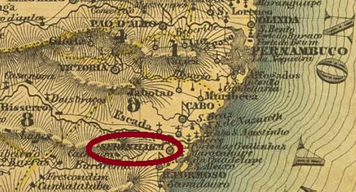
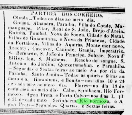
Serinhaem (today Sirinhaém) is a very old settlement by Brazilian standards, which was already called Villa Formosa de Nossa Senhora da Conceição de Serinhaem in January 1627. The village was located on the south bank of the river of the same name, 75 km south of the capital Recife. The name from the Tupi language means crab dish. Sirinhaem did not become a town until June 1895, and it has also been a município since December 1938.
So far it has not been possible to find out when the local post office first opened, but it must have been before April 1836. Because at that time there were already two postal lines running from Recife through Serinhaem, as reported in the regional press:
Diario de Pernambuco, 7 April 1836
The post office was closed in January 1851, according to Aureo G. Santos in Agências de Correio Criadas e Suprimidas 1851, 1855, 1856 e 1857 (Brasil Filatélico 181, Rio de Janeiro, 1977):
Aureo G. Santos (op.cit.)
The second post opening occurred in 1854, as both the Imperial Mail Register (Tabella das Agencias do Correio do Imperio, Rio de Janeiro, 1885) and the Postal Report (Relatório Postal) for 1886 reported in agreement.
Only one postmark of the Empire has been seen so far: SPE-0595c (Coll. Jorge L. Pedreira) is a French type and as a double circle bears the inscription SERINHAEM above and the typical star between brackets below. The dates in the centre are mostly missing, but so far oscillate between 1886 and at least 1887.
Villiers de l’Ile Adam: Carta (…) das Provincias de Pernambuco, Alagoas e Sergipe, 1848
Serinhaem (heute Sirinhaém) ist eine für brasilianische Verhältnisse sehr alte Siedlung, die bereits im Januar 1627 Villa Formosa de Nossa Senhora da Conceição de Serinhaem hieß. Der Ort lag am Südufer des gleichnamigen Flusses, 75 km südlich der Hauptstadt Recife entfernt. Der Name aus der Tupi-Sprache bedeutet Krebsgericht. Der Aufstieg zur Stadt erfolgte erst im Juni 1895, seit Dezember 1938 ist Sirinhaém auch ein Município.
Bisher war es nicht möglich herauszufinden, wann das örtliche Postamt erstmals eröffnete, muss aber vor April 1836 gewesen sein. Denn zu diesem Zeitpunkt gab es bereits zwei Postlinien, die von Recife aus durch Serinhaem führten, wie die Regionalpresse berichtet:
Nur ein Poststempel des Kaiserreichs war bisher zu sehen: SPE-0595c (Samml. Jorge L. Pedreira) ist ein Französischer Typus und als Doppelkreis trägt oben die Inschrift SERINHAEM und unten den typischen Stern zwischen Klammern. Die Daten in der Mitte fehlen meistens, aber pendeln bisher zwischen 1886 und mindestens 1887.
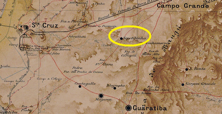
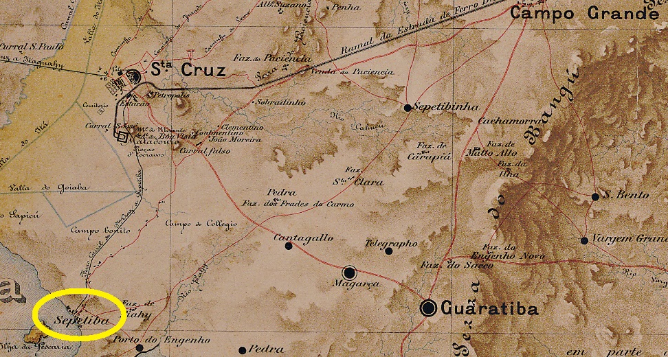
Sepetibinha is another village that has disappeared from the map. The small settlement near Campo Grande was located south of the railway road to Santa Cruz, about 60 km west of the imperial capital of Rio de Janeiro. Today, the village belongs to the district of Guaratiba.
As Nova Monteiro writes in Administrações e Agencias Postaes do Brasil Imperio (Brasil Filatelico/RJ, 1934-5; Reprint SPP 1994-1999), there was a post office there from May 1867, but it was closed around 1882, still during the Empire, as Paulo Novaes reports in agenciaspostais.com.br. No postmark from there has been seen so far, it must be a rarity.
Bellegard-Niemeyer: Carta Corographica do Rio de Janeiro, 1867
Sepetibinha ist wieder eine heute von der Landkarte verschwundene Ortschaft. Die kleine Siedlung bei Campo Grande lag südlich der Bahnstrasse nach Santa Cruz, ca. 60 km westlich der kaiserlichen Hautpstadt Rio de Janeiro entfernt. Heute gehört der Ort zum Stadtteil Guaratiba.
Wie Nova Monteiro in Administrações e Agencias Postaes do Brasil Imperio (Brasil Filatelico/RJ, 1934-5; Reprint SPP 1994-1999) schreibt, gab es dort ein Postamt ab Mai 1867. Allerdings wurde dieses ca. 1882, also noch im Kaiserreich geschlossen, wie Paulo Novaes in agenciaspostais.com.br berichtet. Bisher war kein Poststempel von dort zu sehen, er muss eine Seltenheit sein.
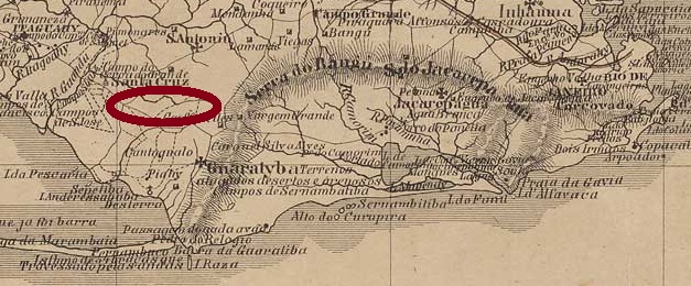
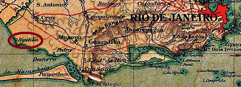
Sepetiba was a freguesia on the Atlantic Ocean belonging to the imperial curato of Santa Cruz, about 70 km west of the capital Rio de Janeiro. The word comes from the Tupi-Guarani language and means place with many reeds. Today it is a district of Rio, without the tourist charm of the better-known beaches, but remaining bucolic and peaceful, not least due to the presence of a military base nearby.
The local post office was established in May 1880, according to the Rio Press:
Jornal do Commercio, 28.05.1880
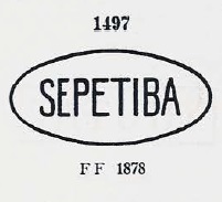
The first postmark is SMN-0185a and was already presented by Paulo Ayres in Catálogo de Carimbos Brasil-Império (S. Paulo, 1937, 1942) under No. 1497:
SMN-0185a (P.A. 1497)
It was followed by SMN-0185b (Coll. Dieter Kerkhoff): a double circle with the inscription SEPETIBA above and an ornament in lozenge below formed by four small lozenges. The only copy so far bears a date from 1893 in the centre.
Almanak Laemmert, 1892
Sepetiba war eine Freguesia am Atlantik, die dem kaiserlichen Curato von Santa Cruz angehörte, ca. 70 km westlich der Hauptstadt Rio de Janeiro entfernt. Das Wort stammt aus der Tupi-Guarani-Sprache und bedeutet Ort mit viel Schilf. Heute ist die Ortschaft ein Stadtteil Rios, zwar ohne den touristischen Charme der bekannteren Strände, doch bukolisch und friedlich geblieben, nicht zuletzt durch die Anwesenheit einer Militärbasis in der Nähe.
Das örtliche Postamt entstand im Mai 1880, wie aus der Rio-Presse hervorgeht:
Ihm folgte SMN-0185b (Samml. Dieter Kerkhoff): ein Doppelkreis mit der Inschrift SEPETIBA oben und einem Ornament in Raute unten, das aus vier kleinen Rauten gebildet wird. Das bisher einzige Exemplar trägt in der Mitte ein Datum aus 1893.
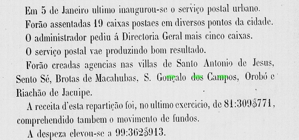
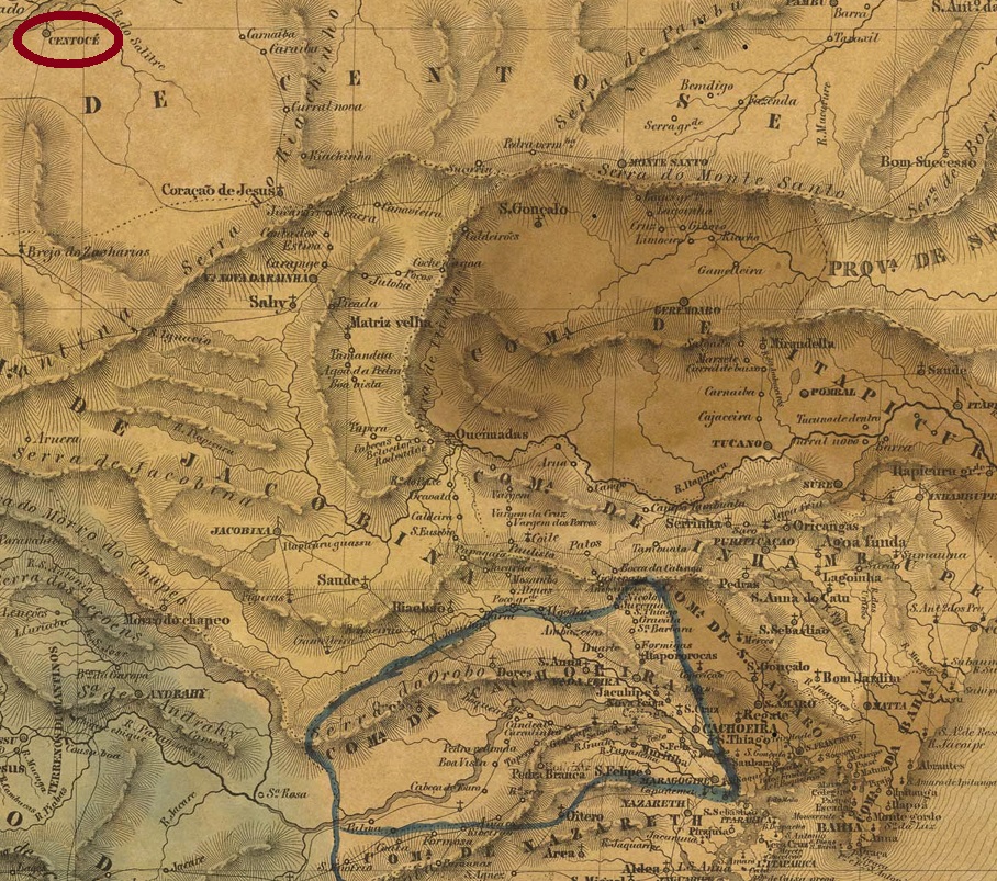
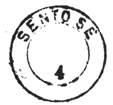
Sento Sé already had a chapel called São José da Barra de Sento Sé in 1719 and was located on the south bank of the mythical São Francisco River, barely 700 km northwest of the former colonial capital Salvador da Bahia. In July 1832, the place became a freguesia, and in January 1883, a villa in its own município.
The Imperial Mail Register (Tabella das Agencias do Correio do Imperio, Rio de Janeiro, 1885) lists the local post office from 1879. However, as this agency does not appear in the Imperial Postal Guide (Guia Postal do Imperio) of 1880, it is more likely that its actual creation and commissioning took place later, as shown in the Provincial President’s Report for 1881:
Relatório (…) do Conselho Interino do Governo da Bahia, 1881
The only postmark in the 19th century is SBA-0850a, as shown in Carimbos Postais – século XIX, (Rio de Janeiro, 1989) by Cicero A. Almeida:
SBA-0850a (MPT 760)Villiers de l’Ile Adam: Carta (…) da Provincia da Bahia, 1848
Sento Sé hatte bereits 1719 eine Kapelle namens São José da Barra de Sento Sé und lag am Südufer des mythischen Flusses São Francisco, knapp 700 km nordwestlich der ehemaligen Kolonialhauptstadt Salvador da Bahia entfernt. Im Juli 1832 wurde der Ort zu einer Freguesia, und im Januar 1883 zur Villa im eigenen Município.
Das Verzeichnis der kaiserlichen Postämter (Tabella das Agencias do Correio do Imperio, Rio de Janeiro, 1885) listet das örtliche Postamt ab 1879 auf. Da aber diese Agentur nicht im Kaiserlichen Postführer (Guia Postal do Imperio) von 1880 zu sehen ist, ist wahrscheinlicher, dass sich ihre tatsächlichen Entstehung und Inbetriebnahme erst später stattfand, wie im Bericht des Provinzpräsidenten für 1881 hervorgeht:
Relatório (…) do Conselho Interino do Governo da Bahia, 1881
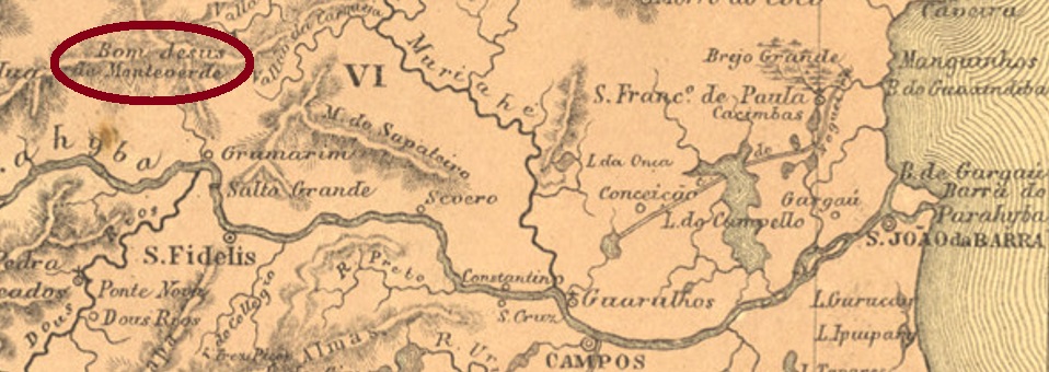
Other names: Bom Jesus do Monte Verde, Monte Verde
See also Bom Jesus do Monte Verde (R. Koester: Carimbologia V)
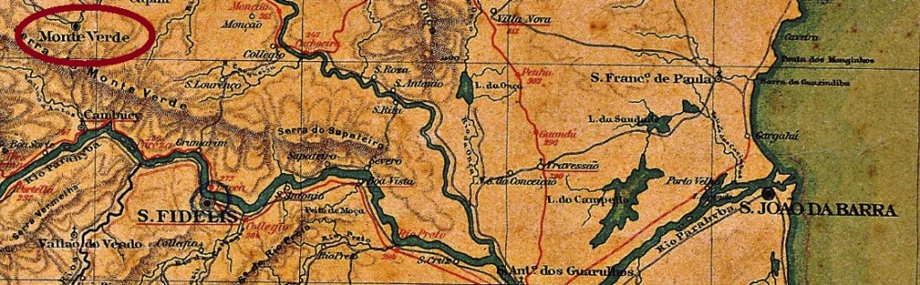
Senhor Bom Jesus do Monte Verde (Our Lord, Kind Jesus of Green Mountain) was a freguesia of São Fidelis from November 1861, about 280 km northeast of the capital Rio de Janeiro. In May 1891, the village rose to become a vila called Monte Verde within its own município but lost political administrative autonomy in December 1929. Since then, Monte Verde has been a district in the município of Cambuci.
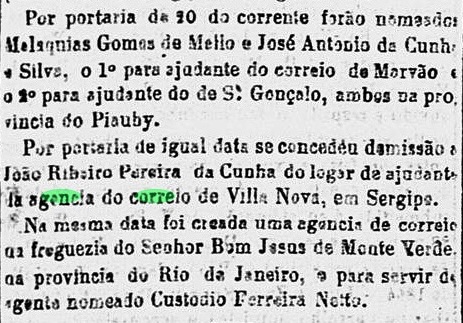
The local post office was established in July 1864, as reported by the Rio press:
Correio Mercantil/RJ, 25 July 1864
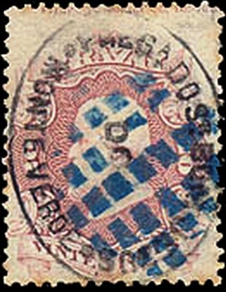
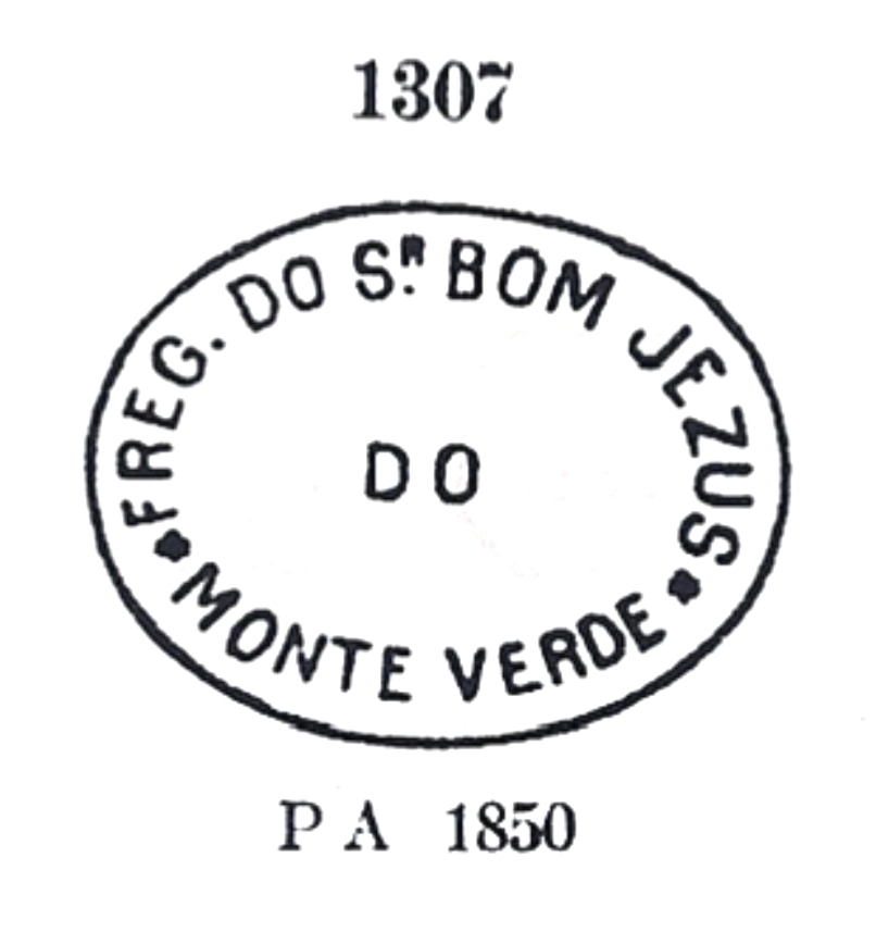
In his Catálogo de Carimbos Brasil-Império (S. Paulo, 1937, 1942) Paulo Ayres shows two early postmarks from this place. However, R. Koester in Carimbologia V considers the first of them (P.A. 1306) to be wrong. The other one (P.A. 1307) would then be SRJ-0205a, which was in use from the beginning until 1883:
SRJ-0205a (P.A. 1307)
A mute cancellation used in conjunction with SRJ-0205a also dates from this period:
1866ff (RHM)
Later postmarks of this locality bear the inscription BOM JESUS.
Almanak Laemmert, 1892
Andere Namen: Bom Jesus do Monte Verde, Monte Verde
Siehe auch Bom Jesus do Monte Verde (R. Koester: Carimbologia V)
Senhor Bom Jesus do Monte Verde (Unser Herr, gütiger Jesus aus dem Grünen Berg) war ab November 1861 eine Freguesia von São Fidelis, die ca. 280 km nordöstlich der Hauptstadt Rio de Janeiro entfernt lag. Im Mai 1891 stieg der Ort zu einer Vila namens Monte Verde mit eigenem Município, verlor aber die politische Verwaltungsautonomie im Dezember 1929. Seitdem ist Monte Verde ein Distrikt im Município von Cambuci.
Das örtliche Postamt wurde im Juli 1864 ins Leben gerufen, wie die Presse aus Rio berichtete:
Correio Mercantil/RJ, 25.07.1864
In Catálogo de Carimbos Brasil-Império (S. Paulo, 1937, 1942) zeigt Paulo Ayres gleich zwei frühe Poststempel aus diesem Ort. Allerdings hält R. Koester in Carimbologia V den ersten davon (P.A. 1306) für falsch. Der andere (P.A. 1307) wäre dann SRJ-0205a, der vom Beginn an bis 1883 in Gebrauch war:
SRJ-0205a (P.A. 1307)
Aus dieser Zeit stammt auch eine stumme Abstempelung, die in Verbindung zu SRJ-0205a benutzt wurde:
1866ff (RHM)
Spätere Posttempel dieser Ortschaft tragen die Inschrift BOM JESUS.