Categories
Carimbologia S

Senhor Bom Jesus da Gurgueia, Piauí (SPI-0210)

Villiers de l’Ile Adam: Carta (…) da Provincia do Piauhy, 1850

Other names: Buritizinho, Bom Jesus (1943)

See also Bom Jesus do Gurgueia (R. Koester: Carimbologia V)

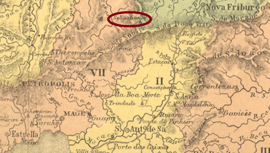
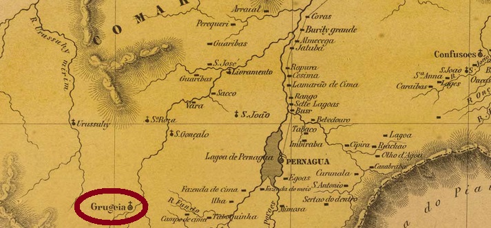
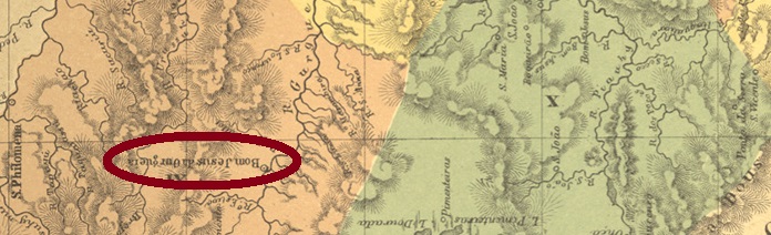
This locality is said to have been first called Buritizinho, then became a district of Parnaguá in September 1838, lying northwest of the Gurgueia River, 600 km south of the future provincial capital of Teresina. The village rose to the status of a villa in December 1855, and in August 1843 its name was simplified to Bom Jesus. Today, it is the centre of a region that wants to separate from the state of Piauí as the new state of Gurgueia.

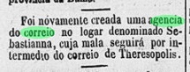
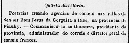
Two dates have been found for the origin of the local post office, but it is possible that the second date is a transcription error. Nova Monteiro, in Administrações e Agencias Postaes do Brasil Imperio (Brasil Filatelico/RJ, 1934-5; Reprint SPP 1994-1999) writes March 1861 for it, which is confirmed by the Rio press:

Correio Mercantil/RJ, 28.03.1861

However, Reinhold Koester (Carimbologia V) has given 1881 as the year of origin. Now this agency was mentioned in the reports of the Provincial President (Relatorio do Presidente da Provincia) for 1867, 1870 and 1877, and it is also listed in the Imperial Postal Guide (Guia Postal do Império) from 1880. Koester is probably wrong here.

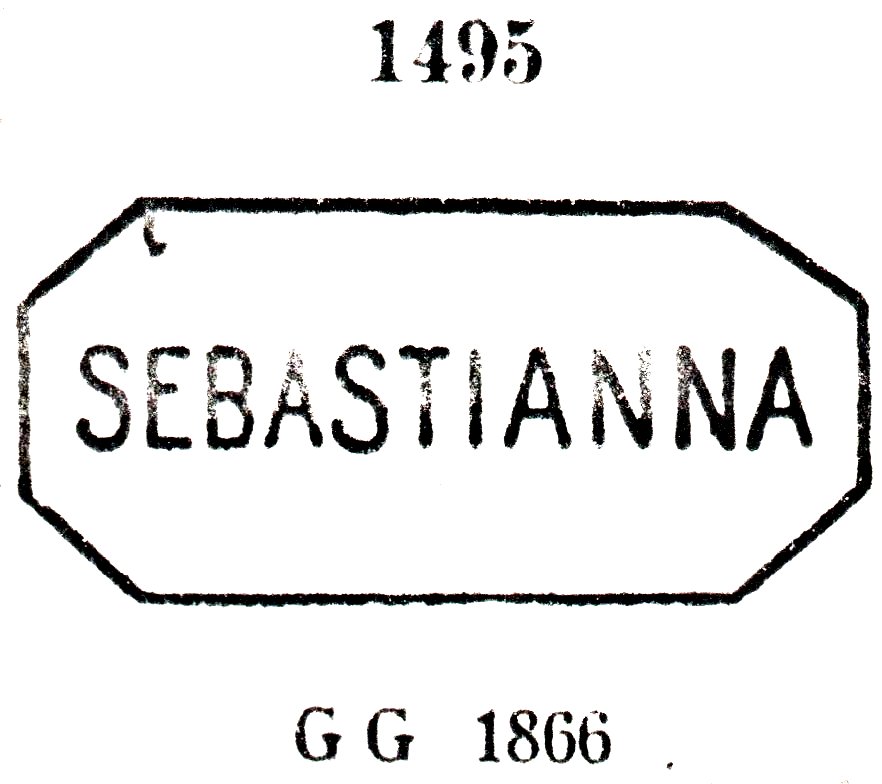
So far, no postmark has been found from this place in the imperial period.

Atlas do Imperio do Brasil, 1868

Andere Namen: Buritizinho, Bom Jesus (1943)

Siehe auch Bom Jesus do Gurgueia (R. Koester: Carimbologia V)

Diese Ortschaft soll zuerst Buritizinho geheißen haben, wurde dann im September 1838 zu einem Distrikt von Parnaguá, der nordwestlich des Flusses Gurgueia lag, 600 km südlich der künftigen Provinzhaupt Teresina entfernt. Der Ort stieg im Dezember 1855 zur Villa auf und hat im August 1843 den Namen zu Bom Jesus vereinfacht bekommen. Heute ist er das Zentrum einer Region, die sich als neues Bundesstaat Gurgueia vom Staat Piauí trennen möchte.

Es wurden zwei Daten für die Entstehung des örtlichen Postamtes gefunden, aber womöglich handelt es sich beim zweiten Datum um einen Abschreibfehler. Nova Monteiro schreibt in Administrações e Agencias Postaes do Brasil Imperio (Brasil Filatelico/RJ, 1934-5; Reprint SPP 1994-1999) dafür den März 1861, was durch die Presse aus Rio bestätigt wird:

Correio Mercantil/RJ, 28.03.1861

Allerdings hat Reinhold Koester (Carimbologia V) das Jahr 1881 als Entstehungsjahr angegeben. Nun wurde diese Agentur in den Berichten des Provinzpräsidenten (Relatorio do Presidente da Provincia) für 1867, 1870 und 1877 erwähnt, und im kaiserlichen Postführer (Guia Postal do Império) aus 1880 ist sie auch aufgelistet. Hier wird Koester wohl falsch liegen.

Bisher wurde kein Poststempel in der Kaiserzeit aus diesem Ort gefunden.

Categories
Carimbologia S

Sebastianna, Rio de Janeiro (SRJ-1580)

Atlas do Imperio do Brasil, 1868

Print edition update, on October 25, 2021

Other names: Venda Nova, Nhunguaçu, Vale de Bonsucesso (1990)

Sebastianna was a district of Nova Friburgo, located on the river of the same name, about 120 km northeast of the capital Rio de Janeiro. In December 1901, the place changed to the Município of Teresópolis. The place name was changed twice after that: in December 1843 to Nhunguaçu and in April 1990 to the still current Vale de Bonsucesso.

Two foundation dates for the local post office were found. Paulo Novaes writes March 1869 in agenciaspostais.com.br. The agency was closed sometime later, as a reopening was announced in the Rio press in July 1876:

Gazeta de Noticias, 14 July, 1876

Three 19th century postmarks were seen. SRJ-1580a is the oldest of them; it was used at least until 1877 and is also illustrated by Paulo Ayres in Catálogo de Carimbos Brasil-Império, (S. Paulo, 1937, 1942) under No. 1495:

SRJ-1580a (P.A. 1495)

It was followed by SRJ-1580b (Coll. José A. Junges): a double circle with the inscription SEBASTIANNA above and an ornament in lozenge below, dated in the centre from 1886 to 1890. SRJ-1580c (Coll. José A. Junges) could already be Republican, as its earliest date is from 1893. The double circle reads the same inscription as before, the ornament at the bottom is now X-shaped.

agenciaspostais.com.br

Printausgabe-Aktualisierung, am 25. Oktober 2021

Andere Namen: Venda Nova, Nhunguaçu, Vale de Bonsucesso (1990)

Sebastianna war ein Distrikt von Nova Friburgo, der am gleichnamigen Fluss lag, ca. 120 km nordöstlich der Hauptstadt Rio de Janeiro entfernt. Im Dezember 1901 wechselte der Ort zum Município von Teresópolis. Der Ortsname wurde danach zweimal geändert: im Dezember 1843 zu Nhunguaçu und im April 1990 zum noch aktuellen Vale de Bonsucesso.

Zwei Gründungsdaten fürs örtliche Postamt wurden gefunden. Paulo Novaes schreibt in agenciaspostais.com.br den März 1869. Die Agentur wurde irgendwann später geschlossen, denn eine Wiedereröffnung wurde im Juli 1876 in der Rio-Presse bekannt gemacht:

Gazeta de Noticias, 14.07.1876

Drei Poststempel aus dem 19. Jahrhundert sind vorhanden. SRJ-1580a ist der älteste davon; er wurde mindestens bis 1877 verwendet und ist auch bei Paulo Ayres im Catálogo de Carimbos Brasil-Império, (S. Paulo, 1937, 1942) unter Nr. 1495 abgebildet:

SRJ-1580a (P.A. 1495)

Ihm folgte SRJ-1580b (Samml. José A. Junges): Ein Doppelkreis mit der Inschrift SEBASTIANNA oben und einem Ornament in Raute unten, datiert in der Mitte von 1886 bis 1890. SRJ-1580c (Samml. José A. Junges) könnte bereits republikanisch sein, da sein frühestes Datum aus 1893 ist. Im Doppelkreis liest man die gleiche Inschrift wie bisher, das Ornament unten ist nun X-förmig.

Categories
Carimbologia S

Saúde, Sergipe (SSE-0205)

Villiers de l’Ile Adam: Carta (…) das provinicas de Pernambuco, Alagoas e Sergipe, 1848

Print edition update, on October 24, 2021

This post office is one of the biggest enigmas of Carimbologia S2, because the only information about it is a cancel image, shown in Cicero A. Almeida’s Carimbos Postais – século XIX, (Rio de Janeiro, 1989) under no. MPT 789:

SSE-0205a, C.A. Almeida (op.cit.) MPT 789

The cancel is said to belong to the 19th century, but according to the Brazilian Institute for Geography and Statistics (IBGE), the only locality with this name around 1890 was the parish of Nossa Senhora da Saúde near Japaratuba. However, no post office has been found there so far. The alternative location would be the small village of Saúde, which lay on the south bank of the Rio São Francisco, in today’s Município of Santana do São Francisco. The locality was, after all, to be found on maps from 1848 (see above) and 1868 (see below).

Although as little is known of this post office as of its alternative, a postal agency seems more plausible here, since this place was not only registered on maps, but its situation was also strategically important.

Atlas do Imperio do Brasil, 1868

Aktualisierung der Printausgabe, am 24. Oktober 2021

Dieses Postamt stellt ein großes Rätsel der Carimbologia S2 dar, denn die einzige Information darüber ist ein Stempel, der in Cicero A. Almeidas Carimbos Postais – século XIX, (Rio de Janeiro, 1989) unter Nr. MPT 789 abgebildet wurde:

SSE-0205a, C.A. Almeida (op.cit.) MPT 789

Der Stempel soll demnach dem 19. Jahrhundert angehören. Laut der brasilianischen Geografie- und Statistikbehörde (IBGE) die einzige Ortschaft mit diesem Namen um 1890 war die Pfarrei Nossa Senhora da Saúde bei Japaratuba. Allerdings war dort bisher kein Postamt zu finden. Der Alternativort hinzu wäre die kleine Gemeinde Saúde, die am Südufer des Rio São Francisco lag, im heutigen Município von Santana do São Francisco. Diese Ortschaft war immerhin auf Karten von 1848 und 1868 (siehe oben) zu finden.

Auch wenn von diesem Postamt ebenso wenig bekannt ist, wie von seiner Alternative, eine Postagentur erscheint hier plausibler, da dieser Ort nicht nur auf Karten registriert wurde, sondern auch strategisch wichtig lag.

Categories
Carimbologia S

Saúde, Minas Gerais (SMG-3090)

Atlas do Imperio do Brasil, 1868

Another name: Dom Silvério (1938)

Nossa Senhora da Saúde (Our Lady of Health) was a freguesia of Mariana from April 1841, located on the north bank of the Rio do Peixe, barely 90 km northeast of the provincial capital of Ouro Preto. In December 1873, it became a district, which changed to the newly founded Município of Alvinópolis in February 1891. Since December 1938, the place has been the independent Município of Dom Silvério. The name commemorates the Archbishop of Mariana Dom Silvério Gomes Pimenta (1840-1922), who was also a teacher and poet, in addition to being Brazil’s first black archbishop.

As Paula Sobrinho writes in História Postal de Minas Gerais (Belo Horizonte, 1997), there has been a post office there since June 1879. The imperial postmark is SMG- 3090a (Coll. José A. Junges). A double circle with the inscription SAUDE at the top and an ornament in lozenge at the bottom, which is formed by four small lozenges. The dates in the centre were found for the period 1886-1894.

Provincia de Minas Geraes, 1873

Anderer Name: Dom Silvério (1938)

Nossa Senhora da Saúde (Unsere Liebe Frau der Gesundheit) war ab April 1841 eine Freguesia von Mariana, die am Nordufer des Rio do Peixe lag, knapp 90 km nordöstlich der Provinzhauptstadt Ouro Preto entfernt. Im Dezember 1873 wurde daraus ein Distrikt, der im Februar 1891 zum neu gegründeten Município von Alvinópolis wechselte. Seit Dezember 1938 ist der Ort der eigenständige Município von Dom Silvério. Der Name erinnert an den Erzbischof von Mariana Dom Silvério Gomes Pimenta (1840-1922), der auch Lehrer und Dichter war, dazu noch den ersten schwarzen Erzbischof Brasiliens.

Wie Paula Sobrinho in História Postal de Minas Gerais (Belo Horizonte, 1997) schreibt, gibt es dort ein Postamt seit Juni 1879. Der kaiserliche Poststempel ist SMG- 3090a (Samml. José A. Junges). Ein Doppelkreis mit der Inschrift SAUDE oben und einem Ornament in Raute unten, das aus vier kleinen Rauten gebildet wird. Die Daten in der Mitte wurden für den Zeitraum 1886-1894 gefunden.

Categories
Carimbologia S

Saudade (train station/Bahnhof), Rio de Janeiro (SRJ-2260)

Almanak Laemmert, 1892

Saudade (Longing) was a railway station of the E.F. Dom Pedro II company, inaugurated in August 1883 and located in the Município of Barra Mansa, over 130 km northwest of the capital Rio de Janeiro. After the end of the Empire, the railway company was renamed E.F. Central do Brasil, and from 1975 until the end of operations in 1996, the railway line belonged to Rede Ferroviária Federal SA.

As can be read in the Rio press, there was a station post office there since September 1883:

Gazeta de Noticias, 21.09.1883

Two postmarks in double circle have survived from the imperial period: SRJ-2260a (Coll. José A. Junges) has the inscription SAUDADE above and an ornament in lozenge below, its four sides open. Dates in the centre from 1887 to 1889. SRJ-2260b (Coll. Karlheinz Wittig) has the same inscription at the top, the ornament at the bottom is now X-shaped. All dates so far are from the Republic: 1891-1893.

agenciaspostais.com.br

Saudade (Sehnsucht) war ein Bahnhof der E.F. Dom Pedro II-Gesellschaft, der im August 1883 eingeweiht wurde und im Município von Barra Mansa lag, über 130 km nordwestlich der Hauptstadt Rio de Janeiro entfernt. Nach dem Ende des Kaiserreichs wurde die Bahngesellschaft zu E.F. Central do Brasil umbenannt, und von 1975 bis zum Betriebsende 1996 gehörte der Bahnlinie der Rede Ferroviária Federal S.A.

Wie in der Rio-Presse zu lesen ist, gab es dort ein Bahnhofspostamt seit September 1883:

Gazeta de Noticias, 21.09.1883

Zwei Poststempel in Doppelkreis sind in der Kaiserzeit überliefert: SRJ-2260a (Samml. José A. Junges) hat die Inschrift SAUDADE oben und ein Ornament in Raute unten, dessen vier Seiten offen sind. Daten in der Mitte von 1887 bis 1889. SRJ-2260b (Samml. Karlheinz Wittig) hat die gleiche Inschrift oben, das Ornament unten ist nun X-förmig. Alle Daten bisher entstammen der Republik: 1891-1893.

Categories
Carimbologia S

Sardoal, Rio de Janeiro (SRJ-2285)

agenciaspostais.com.br

This early settlement of the Freguesia of Sant’Anna de Cebollas was in the Município of Parahyba do Sul, about 115 km north of the capital Rio de Janeiro. This is how it remained until December 1938, when the place was designated a district in the district of Inconfidência.

According to the postal report (Relatorio dos Correios) of 1887, there was a post office there from March 1887. The imperial postmark is SRJ- 2285a (Coll. José A. Junges): a double circle with the inscription SARDOAL above and an ornament in lozenge below, whose four sides are open. The dates in the middle were found for the period 1887-1896.

Google Maps

Diese frühe Siedlung der Freguesia von Sant’Anna de Cebollas lag im Município von Parahyba do Sul, ca. 115 km nördlich der Hauptstadt Rio de Janeiro entfernt. So ist es bis Dezember 1938 geblieben, als der Ort zum Stadtteil im Distrikt von Inconfidência ernannt wurde.

Wie aus dem Postbericht (Relatorio dos Correios) von 1887 hervorgeht, gab es dort ein Postamt ab März 1887. Der kaiserliche Poststempel ist SRJ- 2285a (Samml. José A. Junges): ein Doppelkreis mit der Inschrift SARDOAL oben und einem Ornament in Raute unten, dessen vier Seiten offen sind. Die Daten in der Mitte wurden für den Zeitraum 1887-1896 gefunden.

Categories
Carimbologia S

Sarapuhy, São Paulo (SSP-1360)

Atlas do Imperio do Brasil, 1868

Other names: Nossa Sra. das Dores da Fazendinha, Sarapuí

Sarapuhy was a freguesia in the Município of Itapetininga from February 1844, located about 150 km west of the provincial capital São Paulo. In March 1872, the place rose to the status of a villa, but in May 1934, the relegation to the district of Itapetininga came back. Then in October 1937, the Município of Sarapuí was finally created.

As shown in the Imperial Mail Register(Tabella das Agencias do Correio do Imperio, Rio de Janeiro, 1885), there has been a post office there since 1874. The imperial postmark is SSP-1360a (Coll.  José A. Junges): a double circle with the inscription SARAPUHY at the top and a (2) at the bottom. The dates in the middle were found for the period 1884-1897.

Villiers de l’Ile Adam: Carta (…) da Provincia de São Paulo, 1847

Andere Namen: Nossa Sra. das Dores da Fazendinha, Sarapuí

Sarapuhy war ab Februar 1844 eine Freguesia im Município von Itapetininga, die ca. 150 km westlich der Provinzhauptstadt São Paulo entfernt lag. Im März 1872 stieg der Ort zur Villa, aber im Mai 1934 kam der Abstieg zum Distrikt von Itapetininga zurück. Dann im Oktober 1937 entstand schließlich der Município von Sarapuí.

Wie aus dem Verzeichnis der kaiserlichen Postämter (Tabella das Agencias do Correio do Imperio, Rio de Janeiro, 1885) hervorgeht, gibt es dort ein Postamt seit 1874. Der kaiserliche Poststempel ist SSP-1360a (Samml. José A. Junges): ein Doppelkreis mit der Inschrift SARAPUHY oben und eine (2) unten. Die Daten in der Mitte wurden für den Zeitraum 1884-1897 gefunden.

Categories
Carimbologia S

Sarandy, Minas Gerais (SMG-3085)

Atlas do Imperio do Brasil, 1868

Print version update, on January 4, 2022

Another name: Sarandira (1943)

The freguesia of N. Sra. do Livramento de Sarandy was created in January 1880, located in the Município of Juiz de Fora, over 240 km south of the provincial capital of Ouro Preto. The town’s name was changed to Sarandira in December 1943, and it remains so today.

The local post office was established in June 1875, according to the regional press:

Diario de Minas, 10.06.1875

Two imperial postmarks were found: SMG-3085a (Coll. José A. Junges) is a double circle – with the outer circle often barely visible – with the inscription SARANDY above and an ornament in cross with wide side wings below. The inner dates have so far been recorded for the period 1885-1899.

SMG-3085b (Coll. Klerman Lopes) appeared after the release of Carimbologia S2:

SMG-3085b (KL) 1884ff
Provincia de Minas Geraes, 1873

Aktualisierung der Printausgabe, am 4. Januar 2022

Anderer Name: Sarandira (1943)

Die Freguesia von N. Sra. do Livramento de Sarandy wurde im Januar 1880 ins Leben gerufen und lag im Município von Juiz de Fora, über 240 km südlich der Provinzhauptstadt Ouro Preto entfernt. Der Ortsname wurde im Dezember 1943 zu Sarandira geändert, und so ist es bis heute geblieben.

Das örtliche Postamt entstand im Juni 1875, wie aus der regionalen Presse hervorgeht:

Diario de Minas, 10.06.1875

Zwei kaiserliche Poststempel waren auffindbar: SMG-3085a (Samml. José A. Junges) ist ein Doppelkreis – wobei der äußere Kreis oft kaum zu sehen ist – mit der Inschrift SARANDY oben und einem Ornament in Kreuz mit breiten Seitenflügeln unten. Die Daten im Inneren wurden bisher für den Zeitraum 1885-1899 registriert.

Nach der Veröffentlichung von Carimbologia S2 erschien auch SMG-3085b (Samml. Klerman Lopes):

SMG-3085b (KL) 1884ff
Categories
Carimbologia S

Saquarema, Rio de Janeiro (SRJ-0965)

Atlas do Imperio do Brasil, 1868

From January 1755, Nossa Senhora de Nazaré de Saquarema was a freguesia of Cabo Frio named by royal decree (Alvará Real) and located on the lagoon of the same name, about 100 km east of the capital Rio de Janeiro. In May 1851, the village rose to the status of an independent villa, but in December 1859 it was again demoted to a district – this time of Araruama. Immediately in July 1860, it was again promoted to villa status, and since January 1890 Saquarema has been a town.

As Nova Monteiro writes in Administrações e Agencias Postaes do Brasil Imperio (Brasil Filatelico/RJ, 1934-5; Reprint SPP 1994-1999), there has been a post office there since March 1839. Two postmarks with place names from the 19th century were found, plus a “mute” cancellation. There are two versions of SRJ-0965a, which was in circulation from the beginning until at least 1877: from Paulo Ayres (Catálogo de Carimbos Brasil-Império, S. Paulo, 1937, 1942) under No. 1494 and from the RHM catalogue, now under P-RJ-44):

SRJ-0965a (P.A.1494RHM P-RJ-44)

It was followed by SRJ-0965b (image from the internet): a double circle with the inscription SAQUAREMA. The inner dates were found for the period 1890-1893.

The mute cancellation (Coll. José A. Junges) was found on a letter from 1868 in connection with SRJ-0965a:

1868 (Coll. J.A. Junges)
Villiers de l’Ile Adam: Carta (…) da Provincia do Rio de Janeiro, 1850

Nossa Senhora de Nazaré de Saquarema war ab Januar 1755 eine durch königliche Verfügung (Alvará Real) genannte Freguesia von Cabo Frio, die an der gleichnamigen Lagune lag, ca. 100 km östlich der Hauptstadt Rio de Janeiro entfernt. Im Mai 1851 stieg der Ort zur eigenständigen Villa, die aber im Dezember 1859 wieder zum Distrikt – diesmal von Araruama – degradiert wurde. Gleich im Juli 1860 erfolgte der erneute Aufstieg zur Villa, und seit Januar 1890 ist Saquarema eine Stadt.

Wie Nova Monteiro in Administrações e Agencias Postaes do Brasil Imperio (Brasil Filatelico/RJ, 1934-5; Reprint SPP 1994-1999) schreibt, gibt es dort seit März 1839 ein Postamt. Zwei Poststempel mit Ortsbezeichnung aus dem 19. Jahrhundert wurden gefunden, dazu eine „stumme“ Entwertung. Von SRJ-0965a, der von Beginn an bis mindestens 1877 im Umlauf war, gibt es zwei Versionen: aus Paulo Ayres (Catálogo de Carimbos Brasil-Império, S. Paulo, 1937, 1942) unter der Nr. 1494 und aus dem RHM-Katalog, nun unter P-RJ-44):

SRJ-0965a (P.A.1494 – RHM P-RJ-44)

Ihm folgte SRJ-0965b (Abb. aus dem Internet): ein Doppelkreis mit der Inschrift SAQUAREMA. Die bisherigen Daten wurden gefunden für den Zeitraum 1890-1893.

Die stumme Entwertung (Samml. José A. Junges) wurde auf einem Brief von 1868 in Verbindung mit SRJ-0965a gefunden:

1868 (Samml. J.A. Junges)

Categories
Carimbologia S

Sapucaia, Rio de Janeiro (SRJ-0960)

Atlas do Imperio do Brasil, 1868

Another name: Ponte de Sapucaia

Sapucaia is a South American chestnut tree (Lecythis Sp.) that is now endangered because of its popularity. The Tupi word means fruit whose eye springs.

Photo: Alex Popovkin (CC BY 2.0)

The village was the freguesia of Santo Antonio de Sapucaia (also written Sapocaia) from September 1871 and was located near Magé on the south bank of the Paraíba do Sul River, over 150 km north of the capital Rio de Janeiro. The place rose to the status of a villa in December 1874 and a town 15 years later.

As Nova Monteiro writes in Administrações e Agencias Postaes do Brasil Imperio (Brasil Filatelico/RJ, 1934-5; Reprint SPP 1994-1999), there had been a post office there since August 1846. This can be confirmed by the official annual report for 1847:

Annuario Politico, Historico e Estatistico, 1847   

Through Paulo Novaes (agenciaspostais.com.br) we know that the agency was closed in June 1861, only to reopen four months later. Four early postmarks have been found, the two older ones were made known by Paulo Ayres (Catálogo de Carimbos Brasil-Império, S. Paulo, 1937, 1942). SRJ-0960a corresponds to P. Ayres No. 1492, which was in circulation ca. 1866-1888 and also occurs in blue, red and green:

SRJ-0960a (P.A. 1492)

SRJ-0960b is P. Ayres No. 1493, which was also in use around the same time:

SRJ-0960b (P.A. 1493) 1866ff-1877ff

Two postmarks in double circle followed. SRJ-0960c (Coll. José A. Junges) has the inscription SAPUCAIA at the top, dates inside go from about 1877 to 1890. SRJ-0960d (image from the Internet) has the same inscription at the top, with a four-leaf ornament in X at the bottom. Dates inside, from 1890 to 1897.

Villiers de l’Ile Adam: Carta (…) da Provincia do Rio de Janeiro, 1850

Anderer Name: Ponte de Sapucaia

Sapucaia ist ein südamerikanischer Kastanienbaum (Lecythis Sp.), der wegen seiner Beliebtheit inzwischen gefährdet ist. Das Tupi-Wort bedeutet Frucht, deren Auge springt.

Foto: Alex Popovkin (CC BY 2.0)

Die Ortschaft war ab September 1871 die Freguesia von Santo Antonio de Sapucaia (auch Sapocaia geschrieben) und lag bei Magé am Südufer des Flusses Paraíba do Sul, über 150 km nördlich der Hauptstadt Rio de Janeiro. Der Ort stieg im Dezember 1874 zur Villa und 15 Jahre später zur Stadt auf.

Wie Nova Monteiro in Administrações e Agencias Postaes do Brasil Imperio (Brasil Filatelico/RJ, 1934-5; Reprint SPP 1994-1999) schreibt, gab es dort ein Postamt seit August 1846. Das kann durch den amtlichen Jahresbericht für 1847 bestätigt werden:

Annuario Politico, Historico e Estatistico, 1847          

Durch Paulo Novaes (agenciaspostais.com.br) wissen wir, dass die Agentur im Juni 1861 geschlossen wurde, um vier Monate später abermals zu eröffnen. Vier frühe Poststempel wurden gefunden, die zwei älteren davon sind durch Paulo Ayres (Catálogo de Carimbos Brasil-Império, S. Paulo, 1937, 1942) bekannt gemacht worden. SRJ-0960a entspricht P. Ayres Nr. 1492, der ca. 1866-1888 im Umlauf war und auch in blau, rot und grün vorkommt:

SRJ-0960a (P.A. 1492)

SRJ-0960b ist P. Ayres Nr. 1493, der auch um die gleiche Zeit verwendet wurde:

SRJ-0960b (P.A. 1493) 1866ff-1877ff

Es folgten zwei Poststempel in Doppelkreis. SRJ-0960c (Samml. José A. Junges) hat oben die Inschrift SAPUCAIA, die Daten im Inneren gehen von ca. 1877 bis 1890. SRJ-0960d (Abb. aus dem Internet) hat oben die gleiche Inschrift, unten ist ein vierblättriges Ornament in X. Daten in der Mitte von 1890 bis 1897.