Categories
Carimbologia S

São Vicente, São Paulo (SSP-1245)

Atlas do Imperio do Brasil, 1868

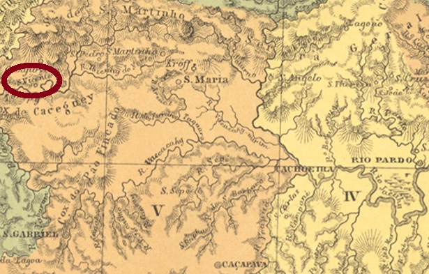
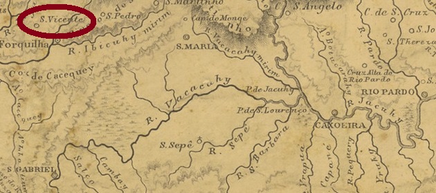
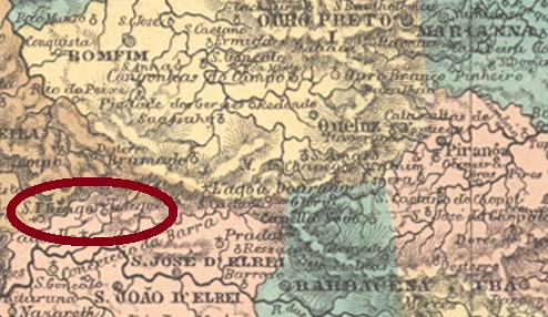
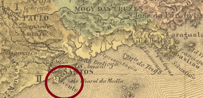
This very old locality was mentioned as early as 1501 by the navigator Americo Vespucci and was planned as a villa by royal decree (Carta Régia) in 1530. However, the foundation of the oldest municipality in Latin America could only take place in January 1532, when the navigator Martim Afonso de Sousa (1500-1564) arrived there. He also became the first governor of this Capitania. Since December 1895, São Vicente has been a town, located over 70 km south of São Paulo.

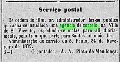
The Imperial Mail Register (Tabella das Agencias do Correio do Imperio, Rio de Janeiro, 1885) lists this post office from 1877 on, and its operating start was confirmed by the provincial press in February of that year:

Correio Paulistano, 25.02.1877

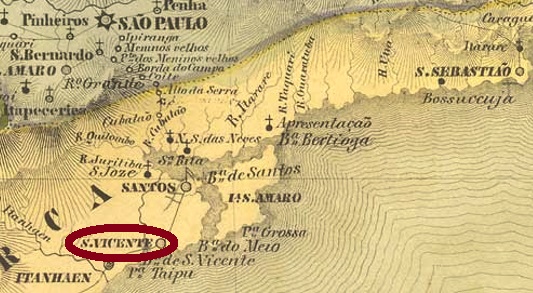
However, the agency was probably closed again soon because it was not included in the imperial Postal Guide (Guia Postal do Império do Brazil, Rio de Janeiro, 1880). Only a town cancel and a mute cancellation were found. SSP-1245a (Coll. Fuad Ferreira Fo.) is a French type: the double circle reads SÃO VICENTE at the top (with tilde between A and O), below there is the typical star between brackets. Dates available until 1901.

The mute stamp was found on a letter from 1882:

Coll. Mario Orsi Jr. (1882)
Villiers de l’Ile Adam: Carta (…) da Provincia de São Paulo, 1847

Diese sehr alte Ortschaft wurde bereits 1501 durch den Seefahrer Americo Vespucci erwähnt und 1530 durch königliche Verfügung (Carta Régia) zur Villa bestimmt. Allerdings konnte die Gründung der ältesten Gemeinde in Lateinamerika erst im Januar 1532 erfolgen, als der Seefahrer Martim Afonso de Sousa (1500-1564) dort ankam. Er wurde auch der erste Gouverneur dieser Capitania. Seit Dezember 1895 ist São Vicente eine Stadt, die über 70 km südlich von São Paulo liegt.

Das Verzeichnis der kaiserlichen Postämter (Tabella das Agencias do Correio do Imperio, Rio de Janeiro, 1885) listet dieses Postamt ab 1877 auf, und dessen Inbetriebnahme wurde im Februar des Jahres durch die Provinzpresse bestätigt:

Correio Paulistano, 25.02.1877

Allerdings wurde die Agentur womöglich bald wieder geschlossen, denn sie ist im kaiserlichen Postführer (Guia Postal do Império do Brazil, Rio de Janeiro, 1880) nicht zu finden. Lediglich ein Ortsstempel und eine stumme Entwertung wurden gefunden. SSP-1245a (Samml. Fuad Ferreira Fo.) ist ein französischer Typus: im Doppelkreis liest man oben SÃO VICENTE (mit Tilde zwischen A und O), unten ist der typische Stern zwischen Klammern. Daten bis 1901 vorhanden.

Der stumme Stempel wurde auf einem Brief aus 1882 gefunden:

Samml. Mario Orsi Jr. (1882)

Categories
Carimbologia S

São Vicente, Rio Grande do Sul (SRS-0380)

Atlas do Imperio do Brasil, 1868

Another name: São Vicente do Sul (1969)

This old freguesia of Rio Pardo became a district in the Município of São Gabriel in April 1846, which was located close to the Arroio Cunha, 380 km west of the provincial capital Porto Alegre. Thirty years later, the place rose to become a vila, renamed General Vargas in 1944. This general was not the former President Getúlio Vargas, but his father, a military man and politician (1844-1943) who was considered a hero in the war against Paraguay. However, the name was probably not pleasant to the military dictatorship from 1964 onwards, so the place name changed to São Vicente do Sul in 1969.

As Nova Monteiro writes in Administrações e Agencias Postaes do Brasil Imperio (Brasil Filatelico/RJ, 1934-5; Reprint SPP 1994-1999), there has been a post office there since July 1866. An early postmark was found, probably not the earliest. SRS-0380b (Coll. José A. Junges) is a double circle with the inscription S. VICENTE above and an ornament in cross below consisting of four converging arrowheads. The dates in the centre vary from 1885 to 1897.

Provincia de São Pedro do Sul, 1877

Anderer Name: São Vicente do Sul (1969)

Diese alte Freguesia von Rio Pardo wurde im April 1846 ein Distrikt im Município von São Gabriel, der nah am Arroio Cunha lag, 380 km westlich der Provinzhauptstadt Porto Alegre entfernt. 30 Jahre später stieg der Ort zur Vila auf, die 1944 zu General Vargas umbenannt wurde. Dieser General war nicht der ehemaliger Präsident Getúlio Vargas, sondern dessen Vater, ein Militär und Politiker (1844-1943), der als Held im Krieg gegen Paraguay gilt. Allerdings war der Name der Militärdiktatur ab 1964 wohl nicht angenehm, so wechselte der Ortsnamen 1969 zu São Vicente do Sul.

Wie Nova Monteiro in Administrações e Agencias Postaes do Brasil Imperio (Brasil Filatelico/RJ, 1934-5; Reprint SPP 1994-1999) schreibt, gibt es dort ein Postamt seit Juli 1866. Ein früher Poststempel wurde gefunden, wohl nicht der früheste. SRS-0380b (Samml. José A. Junges) ist ein Doppelkreis mit der Inschrift S. VICENTE oben und einem Ornament in Kreuz unten, das aus vier konvergierenden Pfeilspitzen besteht. Daten in der Mitte von 1885 bis 1897.

Categories
Carimbologia S

São Vicente, Pernambuco (SPE-0570)

Atlas do Imperio do Brasil, 1868

São Vicente was a district in the Município of Timbaúba from April 1864, located on the provincial border with Paraíba, 116 km northwest of the capital Recife. In July 1909, the place rose to the status of vila, and in September 1928, to that of town, which has been called São Vicente Férrer since December 1953, probably to distinguish it from other places of the same name.

From the Imperial Mail Register (Tabella de Agencias do Correio do Império) of 1885, we know that there has been a post office there since 1877. The earliest postmark found so far, SPE-0570b (image from the internet), already has a 20th century date inside. The double circle reads S. VICENTE above and (PERNAMBUCO) below.

Carta Chorographica da Provincia de Pernambuco, 1880

São Vicente war ab April 1864 ein Distrikt im Município von Timbaúba, der an der Provinzgrenze zu Paraíba lag, 116 km nordwestlich der Hauptstadt Recife entfernt. Im Juli 1909 stieg der Ort zur Vila auf, und im September 1928 zur Stadt, die seit Dezember 1953 São Vicente Férrer heißt, wohl um sich von anderen gleichnamigen Orten zu unterscheiden.

Aus dem Verzeichnis der kaiserlichen Postämter (Tabella de Agencias do Correio do Império) von 1885 wissen wir, dass es dort seit 1877 ein Postamt gibt. Der bisher früheste gefundene Poststempel SPE-0570b (Abb. aus dem Internet) hat bereits im Inneren ein Datum im 20. Jahrhundert. Im Doppelkreis liest man S. VICENTE oben und (PERNAMBUCO) unten.

Categories
Carimbologia S

São Vendelino, Rio Grande do Sul (SRS-0378)

coloniasheuser.pro.br

São Vendelino (St. Wendelin of Trier) was, as the name suggests, a German colonist settlement located in a picturesque valley near São João do Monte Negro, over 90 km north of the provincial capital Porto Alegre. In January 1955, the village changed to the Município of São Sebastião do Cahy and in May 1982 to Bom Princípio. Since April 1988, São Vendelino has been an independent município.

The local post office was created barely three weeks before the end of the Empire, on 28 October 1889 to be precise, as reported in the Postal Bulletin of November that year:

Boletim Postal, Nov. 1889

The earliest postmark is SRS-0378a (image from the Internet): a double circle with the inscriptions S. VENDELINO at the top and (S. PEDRO DO SUL) at the bottom. The dates in the middle go up to 1892 so far.

Google Maps

São Vendelino (Sankt Wendel) war, wie der Name schon verrät, eine deutsche Kolonistensiedlung in einem malerischen Tal bei São João do Monte Negro gelegen, über 90 km nördlich der Provinzhauptstadt Porto Alegre entfernt. Im Januar 1955 wechselte der Ort zum Município von São Sebastião do Cahy und im Mai 1982 zu Bom Princípio. Seit April 1988 ist São Vendelino ein eigenständiger Município.

Das örtliche Postamt wurde knapp drei Wochen vor dem Ende des Kaiserreichs ins Leben gerufen, genauer am 28. Oktober 1889, wie der Boletim Postal vom November des Jahres berichtet:

Boletim Postal, Nov. 1889

Der früheste Poststempel ist SRS-0378a (Abb. aus dem Internet): Ein Doppelkreis mit den Inschriften S. VENDELINO oben und (S. PEDRO DO SUL) unten. Die Daten in der Mitte gehen bisher bis 1892.

Categories
Carimbologia S

São Thomé das Letras, Minas Gerais (SMG-2665)

Atlas do Imperio do Brasil, 1868

São Thomé das Letras (St. Thomas of the Writings) was, from March 1840, a freguesia near Lavras, located east of the waterfalls of the Rio do Peixe, over 300 km southwest of the provincial capital of Ouro Preto. In November 1842, the place changed to the município of Baependy. Since December 1962, São Tomé das Letras, as it is written today, has been an independent município.

From Paula Sobrinho’s História Postal de Minas Gerais (Belo Horizonte, 1997) we know that there has been a post office there since September 1877. But since this agency was not listed in the imperial postal guide (Guia Postal do Império) of 1880, the question arises whether the post office was not put into operation later. The only postmark seen so far, SMG-2665a (Coll. José A. Junges), is dated 1891. In this double circle, one reads S. THOMÉ DAS LETRAS at the top, with a four-petalled ornament in a diamond at the bottom.

Villiers de l’Ile Adam: Carta (…) da Provincia de Minas Geraes, 1849

São Thomé das Letras (Skt. Thomas der Schriften) war ab März 1840 eine Freguesia bei Lavras, die östlich der Wasserfälle vom Rio do Peixe lag, über 300 km südwestlich der Provinzhauptstadt Ouro Preto entfernt. Im November 1842 wechselte der Ort zum Município von Baependy. Seit Dezember 1962 ist São Tomé das Letras, wie es heute geschrieben wird, ein selbständiger Município.

Aus Paula Sobrinhos História Postal de Minas Gerais (Belo Horizonte, 1997) wissen wird, dass es dort seit September 1877 ein Postamt gibt. Da aber diese Agentur nicht im kaiserlichen Postführer (Guia Postal do Império) vom 1880 aufgelistet wurde, stellt sich die Frage, ob das Postamt nicht erst später in Betrieb genommen wurde. Auch das bisher einzig gesichteter Poststempel, SMG-2665a (Samml. José A. Junges) zeigt ein Datum aus 1891. In diesem Doppelkreis liest man S. THOMÉ DAS LETRAS oben, unten steht ein vierblättriges Ornament in Raute.

Categories
Carimbologia S

São Thomé, Paraíba (SPB-0220)

Atlas do Imperio do Brasil, 1868

Another name: Sumé (1943)

São Thomé became a district of São João do Cariry in April 1869, located on the south bank of the Rio Sucurú, about 260 km west of the then provincial capital of Parahyba do Norte (now João Pessoa). In June 1862, the village changed to the Município of Alagoa do Monteiro and has been called Sumé since December 1943. Since November 1951, Sumé has been an independent município.

The local post office was established in March 1888, as recorded in the provincial president’s report the following August:

Relatório do Presidente da Província/PB, August 1888

So far, unfortunately, no Imperial postmark from this place could be found.

Provincia de Pernambuco, 1880

Anderer Name: Sumé (1943)

São Thomé wurde im April 1869 zu einem Distrikt von São João do Cariry, der am Südufer des Rio Sucurú lag, ca. 260 km westlich der damaligen Provinzhauptstadt Parahyba do Norte (heute João Pessoa) entfernt. Im Juni 1862 wechselte der Ort zum Município von Alagoa do Monteiro und heißt seit Dezember 1943 Sumé. Seit November 1951 ist Sumé ein eigenständiger Município.

Das örtliche Postamt wurde im März 1888 ins Leben gerufen, wie im Bericht des Provinzpräsidenten im darauffolgenden August festgehalten wird:

Relatório do Presidente da Província/PB, August 1888

Bisher konnte leider kein Poststempel des Kaiserreichs aus diesem Ort gefunden werden.

Categories
Carimbologia S

São Thiago (SMG-3475) – Santiago, Minas Gerais (SMG-3735)

Atlas do Imperio do Brasil, 1868

Today’s São Tiago, formerly also spelled Santiago, was a district of São José d’El Rey from May 1855, located just under 200 km southwest of the provincial capital Ouro Preto. In the early republic, more precisely in September 1891, the district changed to the new município of Bom Sucesso. Since December 1948, São Tiago has been an independent municipality.

A local post office existed there since January 1879, as Paula Sobrinho writes in História Postal de Minas Gerais (Belo Horizonte, 1997). The earliest postmark so far is SMG-3735a (Coll. Márcio Protzner): a double circle with the inscriptions SANTIAGO above and (MINAS) below. The dates at the centre were found for 1885 and 1886. It was followed by SMG-3475a (Col. José A. Junges), also a double circle, now with the inscription S. THIAGO above. All dates in the centre are found so far in the Republic: 1892 to 1904.

Provincia de Minas Geraes, 1873

Das heutige São Tiago, das früher auch Santiago geschrieben wurde, war ab Mai 1855 ein Distrikt von São José d’El Rey, der knapp 200 km südwestlich von der Provinzhauptstadt Ouro Preto entfernt lag. In der früheren Republik, genauer im September 1891, wechselte der Distrikt zum neuen Município von Bom Sucesso. Seit Dezember 1948 ist São Tiago eine selbständige Gemeinde.

Ein örtliches Postamt gab es dort seit Januar 1879, wie Paula Sobrinho in História Postal de Minas Gerais (Belo Horizonte, 1997) schreibt. Der bisher früheste Poststempel ist SMG-3735a (Samml. Márcio Protzner): ein Doppelkreis mit den Inschriften SANTIAGO oben und (MINAS) unten. Die Daten in der Mitte wurden für 1885 und 1886 gefunden. Ihm folgte SMG-3475a (Samml. José A. Junges), auch ein Doppelkreis, nun mit der obigen Inschrift S. THIAGO. Alles Daten in der Mitte sind bisher in der Republik zu finden: 1892 bis 1904.

Categories
Carimbologia S

São Simão de Manhuassú, Minas Gerais (SMG-2660)

Estado de Minas Geraes, 1910

Other names: São Simão, Simonésia (1943)

This other São Simão was, from November 1875, a district of Ponte Nova, located barely 240 km east of the provincial capital Ouro Preto. Two years later, the place was promoted to Villa, but already in January 1880 it was relegated as a district of São Lourenço do Manhuassu. It was not until December 1943 that administrative autonomy was regained, this time under the rather strange name of Simonésia.

Paula Sobrinho writes in História Postal de Minas Gerais (Belo Horizonte, 1997) that there was a post office there from October 1887. A postmark from the end of the 19th century was found, probably not the oldest one. SMG-2660b (Coll. Dieter Kerkhoff) is a double circle with the inscription S. SIMÃO DE MANHUASSU at the top (tilde floating between A and O), and (M.G.) at the bottom. One copy found, dated 1900 in the centre.

Google Maps

Andere Namen: São Simão, Simonésia (1943)

Dieser andere São Simão war ab November 1875 ein Distrikt von Ponte Nova, der knapp 240 km östlich der Provinzhauptstadt Ouro Preto entfernt lag. Zwei Jahre später stieg der Ort zwar zu Villa auf, aber bereits im Januar 1880 folgte der Abstieg als Distrikt von São Lourenço do Manhuassu. Erst im Dezember 1943 wurde die Verwaltungsautonomie wieder erlangt, diesmal unter dem merkwürdigen Ortsnamen Simonésia.

Paula Sobrinho schreibt in História Postal de Minas Gerais (Belo Horizonte, 1997), dass es dort ab Oktober 1887 ein Postamt gab. Ein Poststempel des ausgehenden 19. Jahrhunderts wurde gefunden, wohl nicht der älteste Poststempel. SMG-2660b (Samml. Dieter Kerkhoff) ist ein Doppelkreis mit der Inschrift S. SIMÃO DE MANHUASSU oben (Tilde schwebt zwischen A und O) und (M.G.) unten. Ein Exemplar vorhanden, datiert 1900 in der Mitte.

Categories
Carimbologia S

São Simão, São Paulo (SSP-1240)

Atlas do Imperio do Brasil, 1868

This locality was a district of Casa Branca from March 1842, situated 280 km north of the provincial capital São Paulo. It rose to the status of a villa in April 1865 and has been a town since March 1895.

Through the Imperial Mail Register (Tabella das Agencias do Correio do Imperio, Rio de Janeiro, 1885) we know that there was a post office there since 1869. Here too, the oldest postmark has not yet been found. However, its successor SSP-1240b has already been illustrated by Paulo Ayres in Catálogo de Carimbos Brasil-Império (S. Paulo, 1937, 1942) on page 118:

SSP-1240b (P.A. p. 118) 1881-1894
Cia. Paulista

Diese Ortschaft war ab März 1842 ein Distrikt bei Casa Branca, der 280 km nördlich der Provinzhauptstadt São Paulo entfernt lag. Im April 1865 stieg sie zur Villa auf und ist seit März 1895 eine Stadt.

Durch das Verzeichnis der kaiserlichen Postämter (Tabella das Agencias do Correio do Imperio, Rio de Janeiro, 1885) wissen wir, dass es dort seit 1869 ein Postamt gab. Auch hier konnte der älteste Poststempel bisher nicht gefunden werden. Wohl aber sein Nachfolger SSP-1240b, der bereits durch Paulo Ayres in Catálogo de Carimbos Brasil-Império (S. Paulo, 1937, 1942) auf Seite 118 abgebildet wurde:

SSP-1240b (P.A. S.118) 1881-1894

Categories
Carimbologia S

São Sepé, Rio Grande do Sul (SRS-0375)

Atlas do Imperio do Brasil, 1868

São Sepé was a district near Caçapava from December 1850, located on the west bank of the river of the same name, over 260 km west of the provincial capital Porto Alegre. In April 1864, the place rose to Villa, which also became the municipal headquarters. Since there is no Catholic saint named Sepé, it is assumed that the place name is of indigenous origin. It is possible that it has to do with the legendary Guarani leader Sepé Tiaraju (ca. 1720-1756), who fell in the resistance struggle against Spanish and Portuguese invaders. In 2009, Sepé Tiaraju was named one of Brazil’s 12 National Heroes:

Danubio Gonçalves (1925-2019): Memorial da Epopeia Rio-grandense
(Photo: Eugenio Hansen)

As Nova Monteiro writes in Administrações e Agencias Postaes do Brasil Imperio (Brasil Filatelico/RJ, 1934-5; reprint SPP 1994-1999), there has been a post office there since July 1866. Two 19th century double-circle postmarks have been found, but apparently not the oldest one, unfortunately. SRS-0375b (Coll. José A. Junges) has the inscription S. SEPÉ at the top and internal dates from 1889 to 1890. SRS-0375c (Coll. José A. Junges) will probably be Republican. Here the inscription above is also S. SEPÉ, below one reads (S. PEDRO DO SUL). Dates in the middle from 1896 to 1902.

Villiers de l’Ile Adam: Carta (…) da Provincia de São Pedro do Sul

São Sepé war ab Dezember 1850 ein Distrikt bei Caçapava, der am Westufer des gleichnamigen Flusses lag, gut 260 km westlich der Provinzhauptstadt Porto Alegre entfernt. Im April 1864 stieg der Ort zu Villa auf, die auch der Gemeindesitz wurde. Da es kein katholischer Heiliger namens Sepé gibt, wird angenommen, dass die Ortsbezeichnung indigenen Ursprungs ist. Möglicherweise hat sie mit dem legendären Guarani-Führer Sepé Tiaraju (ca. 1720-1756) zu tun, der im Widerstandskampf gegen spanische und portugiesische Invasoren fiel. 2009 ist Sepé Tiaraju als einer der 12 Nationalen Helden Brasiliens ernannt worden:

Danubio Gonçalves (1925-2019): Memorial da Epopeia Rio-grandense
(Foto: Eugenio Hansen)

Wie Nova Monteiro in Administrações e Agencias Postaes do Brasil Imperio (Brasil Filatelico/RJ, 1934-5; Reprint SPP 1994-1999) schreibt, gibt es dort ein Postamt seit Juli 1866. Zwei Doppelkreis-Stempel des 19. Jahrhunderts wurden gefunden, aber offenbar nicht der älteste davon, leider. SRS-0375b (Samml. José A. Junges) hat oben die Inschrift S. SEPÉ und innere Daten von 1889 bis 1890. SRS-0375c (Samml. José A. Junges) wird wohl republikanisch sein. Hier lautet die obige Inschrift ebenfalls S. SEPÉ, unten liest man (S. PEDRO DO SUL). Daten in der Mitte von 1896 bis 1902.