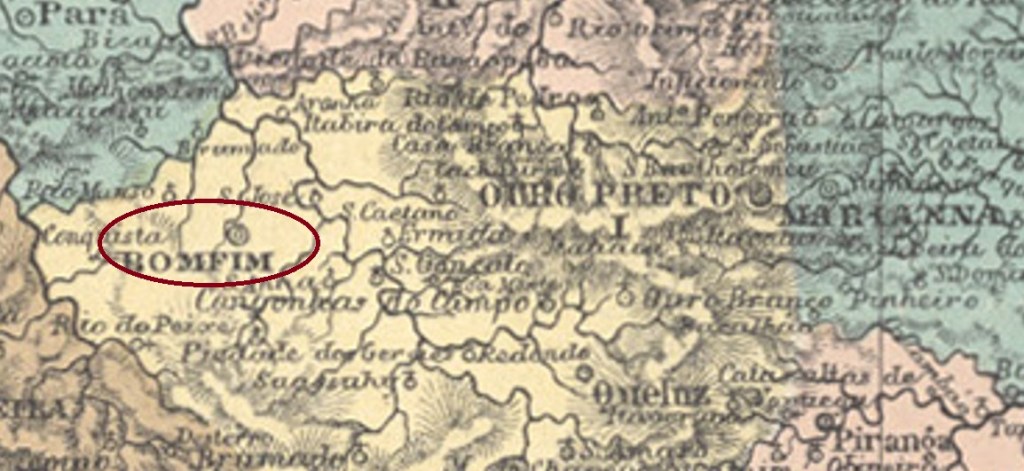
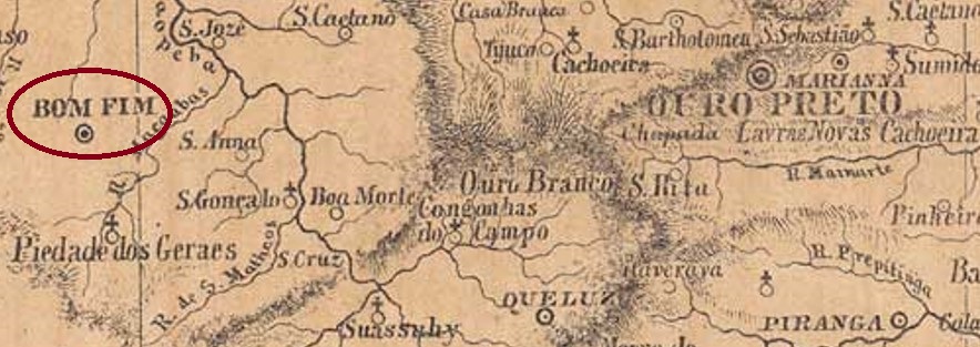
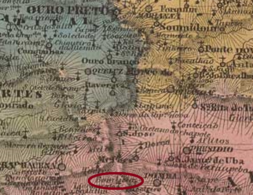
The freguesia of Bomfim do Paraopeba was founded in July 1832 and was located close to the west bank of the Macaúbas River at the Vila of Queluz, 120 km west of the provincial capital Ouro Preto. The place rose to the status of vila in March 1839 and to town in October 1860.
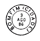
Several sources agree that there had been a post office there since April 1844. The oldest postmark identified with certainty so far is BMG-0380b, already seen with internal dates from 1885 to 1889 and known through Paulo Ayres in his Catálogo de Carimbos Brasil-Império (S. Paulo, 1937, 1942):
BMG-0380b (P.A. p. 120) 1885-1889Provincia de Minas Geraes, 1873
Anderer Name: Bomfim do Paraopeba
Die Freguesia von Bomfim do Paraopeba wurde im Juli 1832 gegründet und lag nah am Westufer des Flusses Macaúbas bei der Vila von Queluz, 120 km westlich der Provinzhauptstadt Ouro Preto entfernt. Der Ort stieg im März 1839 zur Vila und im Oktober 1860 zur Stadt auf.
Mehrere Quellen berichten übereinstimmend, dass es dort ein Postamt seit April 1844 gab. Der bisher älteste sicher identifizierte Poststempel ist BMG-0380b, der bereits mit inneren Daten von 1885 bis 1889 gesehen wurde und durch Paulo Ayres im Catálogo de Carimbos Brasil-Império (S. Paulo, 1937, 1942) bekannt ist:
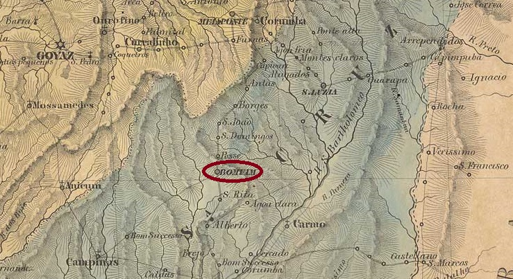
The Freguesia of Senhor do Bomfim was founded in August 1833 and was located 220 km southeast of the provincial capital Goyaz (today: Goiás Velho). By June of the same year, the place was already a vila, which was then elevated to a town in October 1857. In December 1943, the town’s name changed to Silvânia, which is still in use today. The name pays tribute to the Silva family, who apparently held sway there for a long time.
Two dates of foundation for the local post office have been found. First in March 1829, as Nova Monteiro writes in Administrações e Agencias Postaes do Brasil Imperio (Brasil Filatelico/RJ, 1934-5; Reprint SPP 1994-1999). Then again in 1832, as listed in the Directory of Imperial Post Offices (Tabella das Agencias do Correio do Imperio, Rio de Janeiro, 1885).
The first postmark is BGO-0030a, in use from before 1843 to at least 1866, and already shown by R. Koester in Carimbologia V. However, its image shows considerable differences from the one shown by the RHM catalogue:
BGO-0030a (RK/recte RHM P-GO-01)
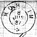
The following postmark is BGO-0030b, which is also known through Koester (op. cit.):
BGO-0030b (RK) 1887Villiers de l’Ile Adam: Carta (…) da Provincia de Goyaz, 1849
Anderer Name: Silvânia (1943)
Die Freguesia von Senhor do Bomfim wurde im August 1833 gegründet und lag 220 km südöstlich der Provinzhauptstadt Goyaz (heute: Goiás Velho). Bereits im Juni desselben Jahres war der Ort eine Vila, die dann im Oktober 1857 zur Stadt erhoben wurde. Im Dezember 1943 änderte sich der Ortsname zum heute noch aktuellen Silvânia. Der Name zollt Tribut an die Familie Silva, die offenbar lange dort das Sagen hatte.
Zwei Gründungszeitpunkte fürs örtliche Postamt wurden gefunden. Erstmals im März 1829, wie Nova Monteiro in Administrações e Agencias Postaes do Brasil Imperio (Brasil Filatelico/RJ, 1934-5; Reprint SPP 1994-1999) schreibt. Dann wieder 1832, wie im Verzeichnis der kaiserlichen Postämter (Tabella das Agencias do Correio do Imperio, Rio de Janeiro, 1885) aufgelistet.
Der erste Poststempel ist BGO-0030a, der von vor 1843 bis mindestens 1866 Verwendung fand und bereits durch R. Koester in Carimbologia V gezeigt wurde. Allerdings zeigt seine Abbildung erhebliche Unterschiede zum vom RHM-Katalog gezeigten Bild:
BGO-0030a (RK/recte RHM P-GO-01)
Der nachfolgende Poststempel ist BGO-0030b, der ebenfalls durch Koester (op. cit.) bekannt ist:
Other names: Bomfim de Palmyra, Bomfim de Santos Dumont, Belmonte, Aracitaba (1943)
The chapel of Senhor do Bomfim do Pomba was built in November 1825 near the Vila of Mariana, 180 km south of the provincial capital of Ouro Preto. In July 1868, the parish changed to the Município of Pomba, after which the place name changed several times: in August 1911 to Bomfim de Palmyra, in July 1931 to Bomfim de Santos Dumont (now in the newly formed Município of Santos Dumont), in December 1938 to Belmonte and finally five years later to Aracitaba, which is still current today. The indigenous name means home of the moon. Since December 1961, Aracitaba has been an independent Município.
As Paula Sobrinho writes in História Postal de Minas Gerais (Belo Horizonte, 1997), there had been a post office there since April 1877. The imperial postmark is BMG-0375a, it occurs with internal dates from 1885 to 1897 and was already presented by R. Koester in Carimbologia V:
BMG-0375a (RK)Villiers de l’Ile Adam: Carta (…) da Provincia de Minas Geraes, 1849
Andere Namen: Bomfim de Palmyra, Bomfim de Santos Dumont, Belmonte, Aracitaba (1943)
Die Kapelle von Senhor do Bomfim do Pomba wurde im November 1825 errichtet und lag bei der Vila von Mariana, 180 km südlich der Provinzhauptstadt Ouro Preto entfernt. Im Juli 1868 wechselte die Pfarrei zum Município von Pomba, danach änderte sich der Ortsnamen mehrmals: im August 1911 zu Bomfim de Palmyra, im Juli 1931 zu Bomfim de Santos Dumont (nun im neu gegründeten Município von Santos Dumont), im Dezember 1938 zu Belmonte und schließlich fünf Jahre später zum heute noch aktuellen Aracitaba. Der indigene Name bedeutet Heimat des Mondes. Seit Dezember 1961 ist Aracitaba ein eigenständiger Município.
Wie Paula Sobrinho in História Postal de Minas Gerais (Belo Horizonte, 1997) schreibt, gab es dort seit April 1877 ein Postamt. Der kaiserliche Poststempel ist BMG-0375a, er kommt mit inneren Daten von 1885 bis 1897 vor und wurde bereits durch R. Koester in Carimbologia V vorgestellt:
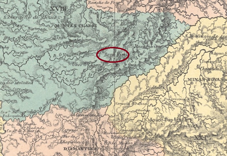
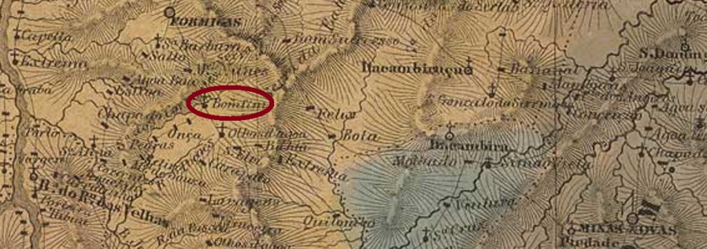
Other names: Macahubas, Jequitahy, Villa Nova de Jequitahy, Bocayuva (1890)
The parish of Senhor do Bomfim was founded in May 1850, located on the south bank of the Guavinipã River in the municipio of Montes Claros, 460 km north of the provincial capital of Ouro Preto. The village rose to become a vila called Jequitahy in November 1873 and has been the município of Bocayuva since June 1890.
As Paula Sobrinho writes in História Postal de Minas Gerais (Belo Horizonte, 1997), there was a post office there since July 1871. The oldest postmark so far, BMG-0370a, has already been presented by R. Koester in Carimbologia V:
BMG-0370a (RK) 1877-1891
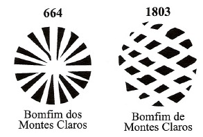
Two mute cancellations also come from there, as can be read in Mute Cancellations of the Brazil Empire/ Carimbos Mudos do Brasil Império (Brazil Philatelic Association, Rio de Janeiro, 2000) de James Dingler and Klerman W. Lopes under no. 664 and 1803:
BPA 664 and 1803 (1879)Villiers de l’Ile Adam: Carta (…) da Provincia de Minas Geraes, 1849
Andere Namen: Macahubas, Jequitahy, Villa Nova de Jequitahy, Bocayuva (1890)
Die Pfarrei von Senhor do Bomfim wurde im Mai 1850 gegründet, sie lag am Südufer des Flusses Guavinipã im Municipio von Montes Claros, 460 km nördlich der Provinzhauptstadt Ouro Preto entfernt. Der Ort stieg im November 1873 zu einer Vila namens Jequitahy auf und ist seit Juni 1890 der Município von Bocayuva.
Wie Paula Sobrinho in História Postal de Minas Gerais (Belo Horizonte, 1997) schreibt, gab es dort ein Postamt seit Juli 1871. Der bisher älteste Poststempel BMG-0370a wurde bereits durch R. Koester in Carimbologia V vorgestellt:
BMG-0370a (RK) 1877-1891
Zwei stumme Abstempelungen kommen auch von dort, wie im Mute Cancellations of the Brazil Empire/ Carimbos Mudos do Brasil Império (Brazil Philatelic Association, Rio de Janeiro, 2000) de James Dingler und Klerman W. Lopes unter Nr. 664 und 1803 zu lesen ist:
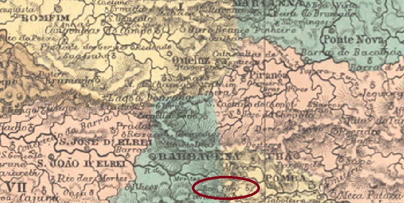
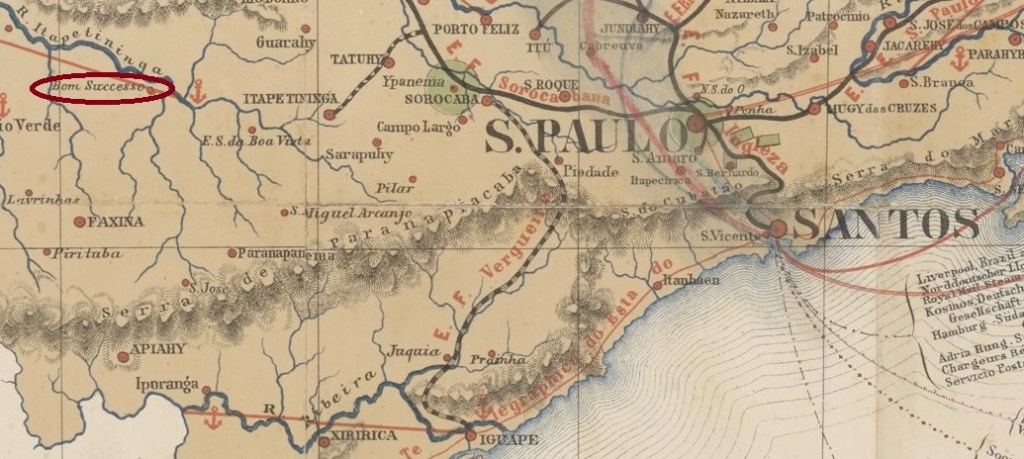
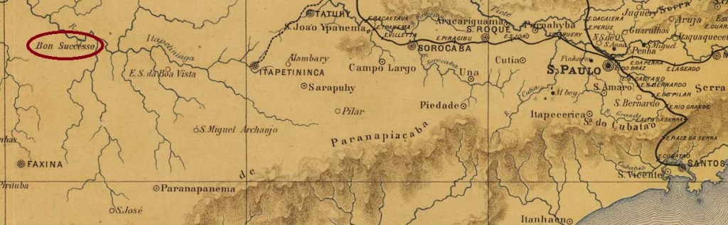
Other names: Bom Successo do Paranapanema, Paranapanema (1944)
The Freguesia of N. Senhor do Bom Successo was founded in April 1859 and was located on the west bank of the Paranapanema River (which was then also called Itapetininga) in the Município of Itapeva da Faxina, 260 km west of the provincial capital São Paulo. Although the village was declared a vila in March 1885, it descended as a district in the Município of Itaí in July 1934. Ten years later, in November 1944, it became the Município of Paranapanema.
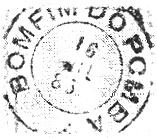
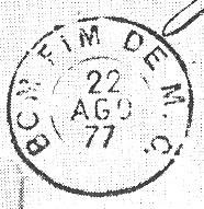
According to the Rio press, there had been a post office there since August 1881:
Diario de Noticias/RJ, 11.08.1881
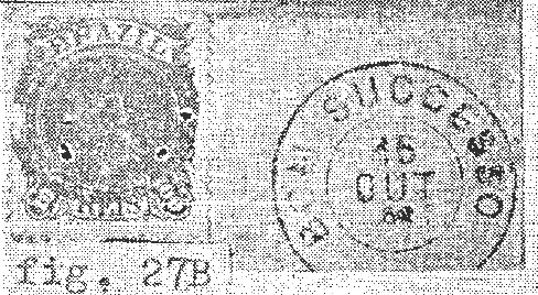
The imperial postmark is BSP-0165a (ill. Cláudio Coelho): a double circle in imitation of a French type, without keeping to the original dimensions, which also exists in blue. The inscription at the top is B. SUCCESSO DE S. PAULO, at the bottom is the star between brackets, for the centre dates from 1885 to 1908 have been found.
J. M. Ribeiro Lisboa: Provincia de São Paulo, 1884
Andere Namen: Bom Successo do Paranapanema, Paranapanema (1944)
Die Freguesia von N. Senhor do Bom Successo wurde im April 1859 gegründet und lag am Westufer des Flusses Paranapanema (der damals auch Itapetininga hieß) im Município von Itapeva da Faxina, 260 km westlich der Provinzhauptstadt São Paulo. Die Ortschaft wurde zwar im März 1885 zur Vila erklärt, stieg aber im Juli 1934 als Distrikt im Município von Itaí ab. Zehn Jahre später, im November 1944 wurde daraus der Município von Paranapanema.
Wie die Presse aus Rio mitteilte, gab es dort ein Postamt seit August 1881:
Diario de Noticias/RJ, 11.08.1881
Der kaiserliche Poststempel ist BSP-0165a (Abb. Cláudio Coelho): ein Doppelkreis in Nachahmung eines französischen Typus, ohne die Originalmaßen einzuhalten, den es auch in Blau gibt. Die Inschrift oben lautet B. SUCCESSO DE S. PAULO, unten ist der Stern zwischen Klammern, für die Mitte sind Daten von 1885 bis 1908 gefunden worden.
Villiers de l’Ile Adam: Carta (…) da Provincia de Minas Geraes, 1849
Another name: Campanha de Trás de Serra de Ibituruna do Rio Grande Pequeno
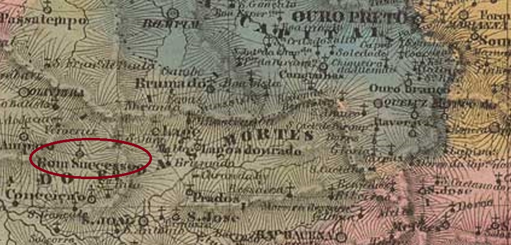
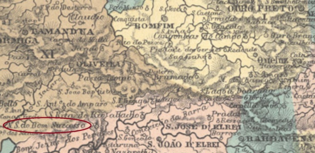
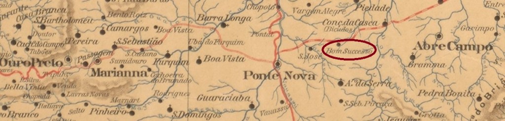
The parish of N. Sra. do Bom Successo was founded in December 1824, it belonged to the Vila of S. João d’El-Rei and was situated on the east bank of the river Pirapetinga, 250 km southwest of the provincial capital Ouro Preto. In 1860, the village changed as Freguesia to the Município of Oliveira, became an independent Vila in July 1872, and in November 1873 a town.
Four different sources agree that the local post office was established in February 1873. The oldest postmark so far is BMG-0350a and has already been made known by R. Koester in Carimbologia V:
BMG-0350a (RK) 1882
It was followed by BMG-0350b, which also occurs in lilac, bears internal dates from 1881 to 1891 and was introduced by Paulo Ayres (Catálogo de Carimbos Brasil-Império, S. Paulo, 1937, 1942):
BMG-0350b (P.A. p.120)
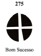
Ayres also shows a mute cancellation from there in Mute Cancellations of the Brazil Empire/ Carimbos Mudos do Brasil Império (Brazil Philatelic Association, Rio de Janeiro, 2000) by James Dingler and Klerman W. Lopes under no. 275:
BPA 275 (P.A. 11c) 1882
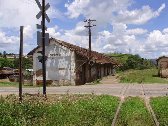
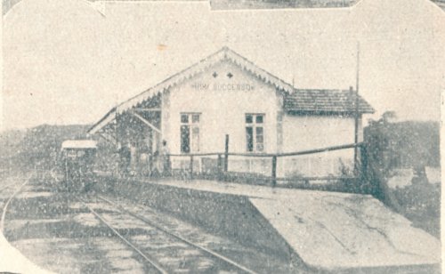
Bom Successo station was inaugurated in October 1887 by the E.F. Oeste de Minas railway company (Paraopeba Line). In 1931 the line changed to Rede Mineira de Viação, in 1965 to V.F. Centro-Oeste, and from 1975 until its closure in 1996 it belonged to Rede Ferroviária Federal S.A. (estacoesferroviarias.com.br). Today, the rails are still there, and the station building is occasionally used as location for cultural events:
1922 (Fig. Mucio J. Vaz in estacoesferroviarias.com.br)2009 (Photo by Samuel Marcos in estacoesferroviarias.com.br)
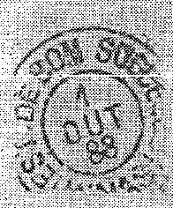
A post office was established in the station in December 1887, as Paula Sobrinho writes in História Postal de Minas Gerais (Belo Horizonte, 1997). The postmark here is BMG-0351a and was also shown by Koester in Carimbologia V:
BMG-0351a (RK) 1888Atlas do Imperio do Brasil, 1868
Anderer Name: Campanha de Trás de Serra de Ibituruna do Rio Grande Pequeno
Die Pfarrei von N. Sra. do Bom Successo wurde im Dezember 1824 gegründet, sie gehörte der Vila von S. João d’El-Rei und lag am Ostufer des Flusses Pirapetinga, 250 km südwestlich der Provinzhauptstadt Ouro Preto entfernt.1860 wechselte die Ortschaft als Freguesia zum Município von Oliveira, wurde im Juli 1872 eine eigenständige Vila und gleich im November 1873 eine Stadt.
Aus vier verschiedenen Quellen erfährt man, dass das örtliche Postamt im Februar 1873 entstanden ist. Der bisher älteste Poststempel ist BMG-0350a und wurde bereits durch R. Koester in Carimbologia V bekannt gemacht:
BMG-0350a (RK) 1882
Ihm folgte BMG-0350b, der auch in lila vorkommt, innere Daten von 1881 bis 1891 trägt und durch Paulo Ayres (Catálogo de Carimbos Brasil-Império, S. Paulo, 1937, 1942) vorgestellt wurde:
BMG-0350b (P.A. p.120)
Ayres zeigt auch eine stumme Abstempelung von dort, die inMute Cancellations of the Brazil Empire/ Carimbos Mudos do Brasil Império (Brazil Philatelic Association, Rio de Janeiro, 2000) von James Dingler und Klerman W. Lopes unter Nr. 275 registriert wurde :
BPA 275 (P.A. 11c) 1882
Der Bahnhof Bom Successo wurde im Oktober 1887 durch die Bahngesellschaft E.F. Oeste de Minas (Paraopeba-Linie) eingeweiht. 1931 wechselte die Linie zur Rede Mineira de Viação, 1965 zur V.F. Centro-Oeste, und von 1975 bis zur Stilllegung 1996 gehörte sie der Rede Ferroviária Federal S.A. (estacoesferroviarias.com.br). Heute sind die Schienen noch da, das Bahnhofsgebäude wird gelegentlich für kulturelle Veranstaltungen benutzt:
1922 (Abb. Mucio J. Vaz in estacoesferroviarias.com.br)2009 (Abb. Samuel Marcos in estacoesferroviarias.com.br)
Im Bahnhof entstand im Dezember 1887 ein Postamt, wie Paula Sobrinho in História Postal de Minas Gerais (Belo Horizonte, 1997) schreibt. Der Poststempel dazu ist BMG-0351a und wurde ebenfalls durch Koester in Carimbologia V gezeigt:
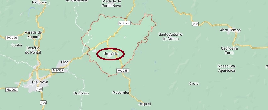
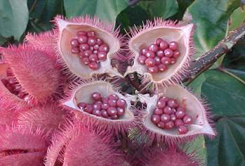
The Arraial of N. Sa. do Bom Successo do Urucú was created in August 1873, belonged to the Município of Ponte Nova and was located 110 km east of the provincial capital of Ouro Preto. The locality rose to freguesia status in September 1887 and has been the Município of Urucânia since December 1962. Urucu is the indigenous name for the shrub Bixa orellana L., family Bixaceae, whose seeds are used as dye and medicine.
Bixa orellana L. (infobibos.com.br)
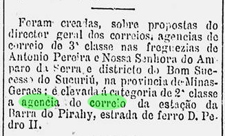
The local post office was established in February 1882, as reported by the Rio press. However, it was under the wrong name of Bom Successo do Sucuriú:
Gazeta de Noticias/RJ, 28.02.1882
The oldest postmark so far is BMG-0355a (coll. Márcio Protzner): a double circle with the inscription BOM SUCCESSO DO URUCÚ, and in the middle dates from 1889 to 1912.
Google Maps
Anderer Name: Urucânia (1962)
Der Arraial von N. Sa. do Bom Successo do Urucú entstand im August 1873, gehörte dem Município von Ponte Nova und lag 110 km östlich der Provinzhauptstadt Ouro Preto entfernt. Die Ortschaft stieg im September 1887 zur Freguesia auf und ist seit Dezember 1962 der Município von Urucânia. Urucu ist der indigene Name für den Strauch Bixa orellana L., Familie Bixaceae, dessen Samen als Farbstoff und Medikamenten gebraucht werden.
Bixa orellana L. (infobibos.com.br)
Das örtliche Postamt entstand im Februar 1882, wie die Presse aus Rio meldete. Allerdings unter dem falschen Namen Bom Successo do Sucuriú:
Gazeta de Noticias/RJ, 28.02.1882
Der älteste Poststempel ist bisher BMG-0355a (Samml. Márcio Protzner): ein Doppelkreis mit der Inschrift BOM SUCCESSO DO URUCÚ, und in der Mitte Daten von 1889 bis 1912.
The Freguesia of N. Sra. da Purificação do Bom Princípio was founded in May 1879 and was located on the west bank of the Caí River in the Município of S. João do Monte Negro, 80 km north of the provincial capital Porto Alegre. The village changed as a district to the Município of S. Sebastião do Caí in January 1955 and has been an independent Município since May 1982.
Reinhold Koester writes in Carimbologia V that the local post office was established in July 1888. The imperial postmark is BRS-0045a (image from the internet): This double circle also occurs in blue, has internal dates of 1889 and 1890 and shows the inscription BOM PRINCIPIO at the top, while an ornament in crossed branches can be seen below.
colonias.heuser.pro.br
Andere Namen: Serraria, Winterschneiss
Die Freguesia von N. Sra. da Purificação do Bom Princípio wurde im Mai 1879 gegründet und lag am Westufer des Flusses Caí im Município von S. João do Monte Negro, 80 km nördlich der Provinzhauptstadt Porto Alegre entfernt. Der Ort wechselte im Januar 1955 als Distrikt zum Município von S. Sebastião do Caí und ist seit Mai 1982 ein eigenständiger Município.
Reinhold Koester schreibt im Carimbologia V, dass das örtliche Postamt im Juli 1888 ins Leben gerufen wurde. Der kaiserliche Poststempel ist BRS-0045a (Abb. aus dem Internet): Dieser Doppelkreis kommt auch in blau vor, hat innere Daten von 1889 und 1890 und zeigt oben die Inschrift BOM PRINCIPIO, während unten ein Ornament in gekreuzten Zweigen zu sehen ist.
Carta da Republica dos Estados Unidos do Brazil, 1892
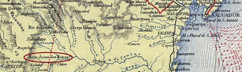
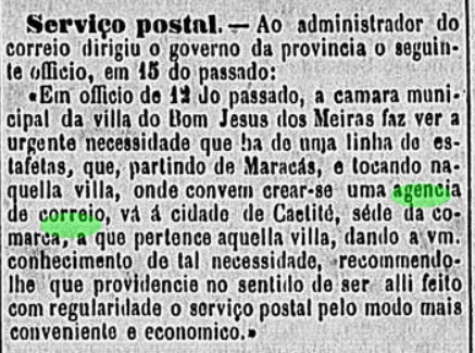
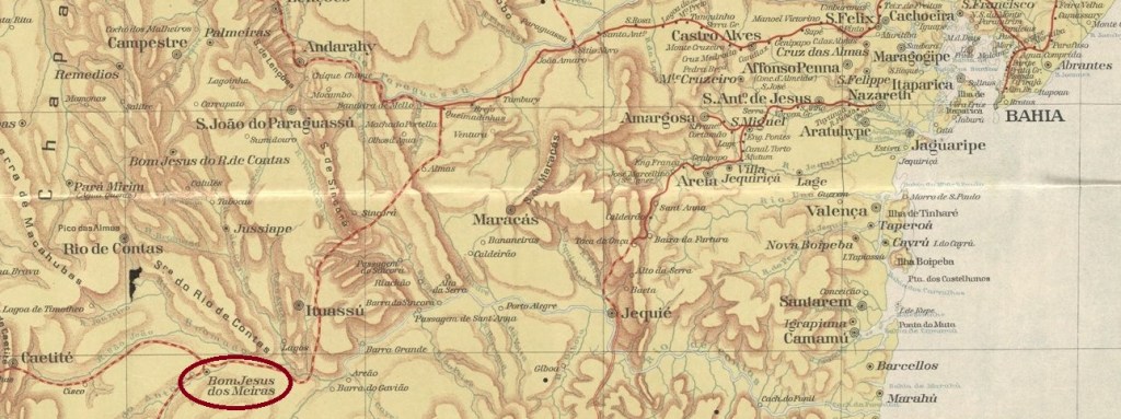
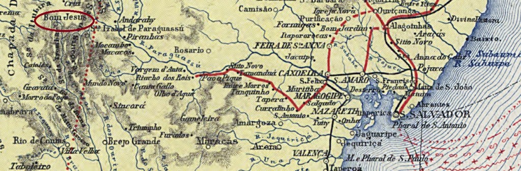
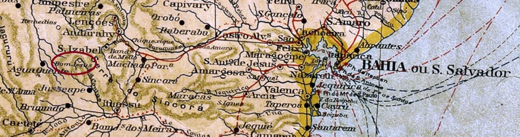
The Freguesia of Senhor Bom Jesus dos Meiras came into being in June 1869 and has its origin in the fazenda called Senhor Bom Jesus do Campo Seco, of the landowner Francisco de Sousa Meira. It was located on the west bank of the Rio do Antonio (a tributary of the Brumado) near the Vila of Caetité, 540 km southwest of the provincial capital Salvador da Bahia. The village rose to the status of Vila in June 1877 and has been the Município of Brumado since June 1931.Two dates of origin for the local post office were found. Reinhold Koester (Carimbologia V) writes October 1872 for it, while in the Directory of Imperial Post Offices (Tabella das Agencias do Correio do Imperio, Rio de Janeiro, 1885) the year 1878 can be read. A note in the regional press indicates that in July 1878 there was still no post office in operation locally:
Correio da Bahia, 02.08.1878
So far, no imperial postmark has been seen from this locality.
Estado da Bahia, 1913
Die Freguesia von Senhor Bom Jesus dos Meiras entstand im Juni 1869 und hat ihren Ursprung in der Fazenda namens Senhor Bom Jesus do Campo Seco, des Großgrundbesitzers Francisco de Sousa Meira. Sie lag am Westufer des Rio do Antonio (ein Nebenfluss des Brumado) bei der Vila von Caetité, 540 km südwestlich der Provinzhauptstadt Salvador da Bahia. Der Ort stieg im Juni 1877 zur Vila auf und ist seit Juni 1931 der Município von Brumado.
Zwei Entstehungsdaten fürs örtliche Postamt wurden gefunden. Reinhold Koester (Carimbologia V) schreibt dafür den Oktober 1872, während im Verzeichnis der kaiserlichen Postämter (Tabelladas Agencias do Correio do Imperio, Rio de Janeiro, 1885) das Jahr 1878 zu lesen ist. Eine Meldung der Regionalpresse deutet darauf hin, dass im Juli 1878 noch kein Postamt vor Ort in Betrieb war:Correio da Bahia, 02.08.1878
Bisher war kein kaiserlicher Poststempel aus dieser Ortschaft zu sehen.
Carta da Republica dos Estados Unidos do Brazil, 1892
Other names: Bom Jesus dos Limões, Anchieta, Piatã (1943)
The parish of Senhor Bom Jesus was established in May 1842 under the Vila of Minas do Rio de Contas and was located on the east bank of the Rio de Contas, 540 km west of the provincial capital Salvador da Bahia. The village rose to the status of Vila in July 1878, after which there were two changes in the place name: in June 1931 to Anchieta and in December 1943 to Piatã. This name is still valid today.
Reinhold Koester writes in Carimbologia V that the local post office was created in September 1882, which is also confirmed by the Directory of Imperial Post Offices (Tabella das Agencias do Correio do Imperio, Rio de Janeiro, 1885). On the other hand, a report of the Provincial President gives the year of creation as 1883:
Relatorio do Conselho Interino do Governo da Bahia, 1884
The last date could be that of the commissioning of the agency. A postmark was found for the 19th century: BBA-0140a (Coll. José A. Junges) is a double circle with the inscription BOM JESUS R.C. above and a star-shaped ornament below. The dates in the centre so far go from 1890 to 1897.
Mappa Geral do Brasil, 1911
Andere Namen: Bom Jesus dos Limões, Anchieta, Piatã (1943)
Die Pfarrei von Senhor Bom Jesus wurde im Mai 1842 unter der Vila von Minas do Rio de Contas errichtet und lag am Ostufer des Rio de Contas, 540 km westlich der Provinzhauptstadt Salvador da Bahia entfernt. Die Ortschaft stieg im Juli 1878 zur Vila, danach gab es zwei Änderungen im Ortsnamen: im Juni 1931 zu Anchieta und im Dezember 1943 zu Piatã. Dieser Name ist noch heute gültig.
Reinhold Koester schreibt in Carimbologia V, dass das örtliche Postamt im September 1882 entstanden ist, was auch vom Verzeichnis der kaiserlichen Postämter (Tabella das Agencias do Correio do Imperio, Rio de Janeiro, 1885) bestätigt wird. Dagegen nennt der Bericht des Provinzpräsidenten das Enstehungsjahr 1883:
Relatorio do Conselho Interino do Governo da Bahia, 1884
Letzter Termin könnte der von der Inbetriebnahme der Agentur sein. Ein Poststempel wurde für das 19. Jahrhundert gefunden: BBA-0140a (Samml. José A. Junges) ist ein Doppelkreis mit der Inschrift BOM JESUS R.C. oben und einem sternförmigen Ornament unten. Die Daten in der Mitte gehen bisher von 1890 bis 1897.