Categories
Carimbologia A-B

Antonio Prado (train station/Bahnhof), Minas Gerais (AMG-0095)

Estado de Minas Geraes, 1910

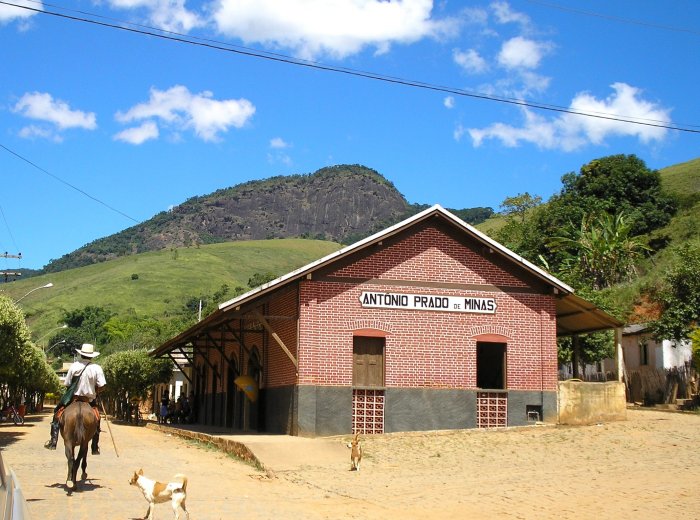
Another name: Antonio Prado de Minas (1962)

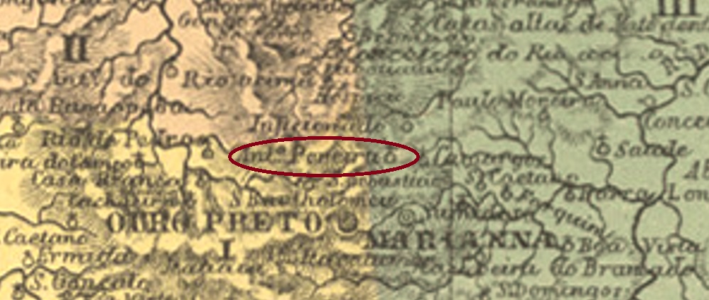
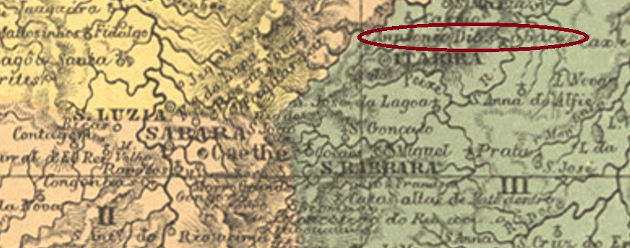
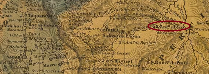
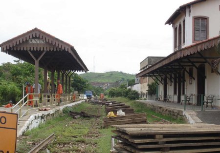
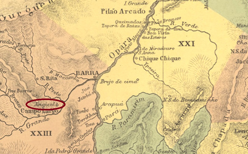
Antonio Prado station was inaugurated in January 1886 by the E.F. Leopoldina, Manhuassú Branch, and was located in the Município of S. Paulo do Muriaé on the provincial border with Rio de Janeiro, 220 km southeast of the capital Ouro Preto. The railway line belonged to Rede Ferroviária Federal S.A. (estacoesferroviarias.com.br) from 1975 until the line was closed in 1979. In the meantime, the rails have been removed and the station building is now the headquarters of a milk producers’ cooperative.

2011 (Photo: Daniela Areal, in estacoesferroviarias.com.br)

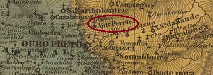
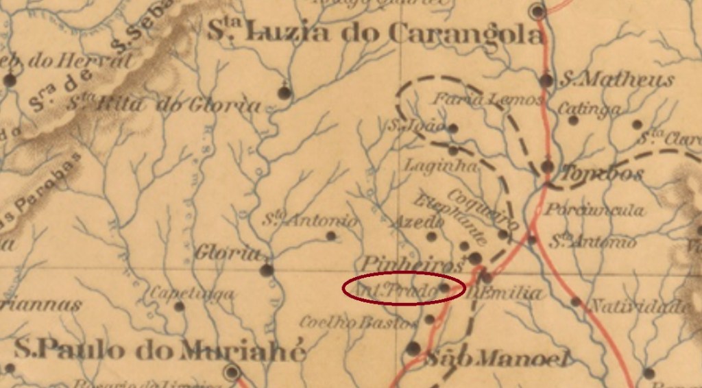
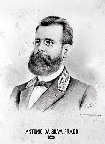
Around the station, the settlement continued to grow, becoming part of the Vila of S. Manuel (May 1891) and – as a district – of the newly created Município of Eugenópolis (December 1948). Since December 1962, it has been in the Município of Antonio Prado de Minas. The name celebrates the Paulista Antonio da Silva Prado (1840-1929), who was a famous personality of the empire as an imperial councillor, coffee farm owner, newspaper publisher, lawyer and also long-time chairman of the Cia. Paulista railway company.

In 1888: Drawing by Amaro do Amaral (Wikipedia)

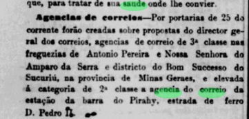
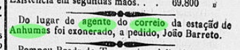
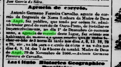
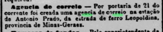
A railway station post office existed from June 1886, as Paula Sobrinho writes in História Postal de Minas Gerais (Belo Horizonte, 1997). This is confirmed by the Rio press:

Jornal do Commercio/RJ, 22.06.1886

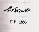
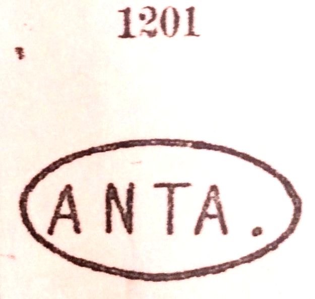
So far only one handwritten postal cancellation in the Empire is known, presented by Paulo Ayres in Catálogo de Carimbos Brasil-Império (S. Paulo, 1937, 1942) on p. 146.

(P.A. p.146) 1886ff
Estrada de Ferro Leopoldina

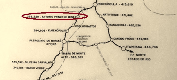
Anderer Name: Antonio Prado de Minas (1962)

Der Bahnhof Antonio Prado wurde im Januar 1886 von der E.F. Leopoldina, Manhuassú-Abzweigung, eingeweiht und lag im Município von S. Paulo do Muriaé an der Provinzgrenze zu Rio de Janeiro, 220 km südöstlich der Hauptstadt Ouro Preto entfernt. Die Bahnlinie gehörte von 1975 bis zur Streckenstilllegung 1979 der Rede Ferroviária Federal S.A. (estacoesferroviarias.com.br). Inzwischen wurden die Schienen entfernt, das Bahnhofsgebäude ist heute der Sitz einer Milcherzeugerkooperative.

2011 (Foto: Daniela Areal, in estacoesferroviarias.com.br)

Rund um den Bahnhof wuchs die Siedlung weiter und ging zur Vila von S. Manuel (Mai 1891) und – als Distrikt – zum neu gegründeten Município von Eugenópolis (Dezember 1948). Seit Dezember 1962 liegt sie im Município von Antonio Prado de Minas. Der name erinnert an den Paulista Antonio da Silva Prado (1840-1929), der als Imperaler Ratsmitglied, Kaffefarmbesitzer, Zeitungsverleger, Jurist und auch langjähriger Vorsitzender der Cia. Paulista Bahngesellschaft eine berühmte Persönlichkeit des Kaiserreichs war.

1888: Zeichnung von Amaro do Amaral (Wikipedia)

Ein Bahnhofspostamt gab es seit Juni 1886, wie Paula Sobrinho in História Postal de Minas Gerais (Belo Horizonte, 1997) schreibt. Das wird durch die Presse aus Rio bestätigt:

Jornal do Commercio/RJ, 22.06.1886

Bisher ist nur eine handschriftliche postalische Entwertung im Kaiserreich bekannt, die von Paulo Ayres in Catálogo de Carimbos Brasil-Império (S. Paulo, 1937, 1942) auf S. 146 vorgestellt wurde.

(P.A. p./S.146) 1886ff
Categories
Carimbologia A-B

Antonio Pereira, Minas Gerais (AMG-0090)

Atlas do Imperio do Brasil, 1868

This very small village (only 481 inhabitants in 1880) was a freguesia from April 1840, belonging to the provincial capital Ouro Preto, 20 km to its north. And so it has remained to this day, with the freguesia becoming a district after the advent of the Republic.

As Paula Sobrinho writes in História Postal de Minas Gerais (Belo Horizonte, 1997), there had been a post office there since February 1882. This is confirmed by a report in the Rio press:

Jornal do Commercio/RJ, 28.02.1882

The agency remained closed between December 1896 and July 1897 (P. Sobrinho, op. cit.). So far, no 19th century postmark from this place has been seen.

Villiers de l’Ile Adam: Carta (…) da Provincia de Minas Geraes

Diese sehr kleine Ortschaft (nur 481 Einwohner im Jahr 1880) war ab April 1840 eine Freguesia, die zur Provinzhauptstadt Ouro Preto gehörte und 20 km nördlich davon lag. Und so ist es bis heute geblieben, wobei nach dem Advent der Republik aus der Freguesia ein Distrikt wurde.

Wie Paula Sobrinho in História Postal de Minas Gerais (Belo Horizonte, 1997) schreibt, gab es dort ein Postamt seit Februar 1882. Das wird durch eine Meldung der Presse aus Rio bestätigt:

Jornal do Commercio/RJ, 28.02.1882

Die Agentur blieb zwischen Dezember 1896 und Juli 1897 geschlossen (P. Sobrinho, op. cit.). Bislang war kein Poststempel aus dem 19. Jahrhundert aus diesem Ort zu sehen.

Categories
Carimbologia A-B

Antonio Dias Abaixo, Minas Gerais (AMG-0085)

Atlas do Imperio do Brasil, 1868

Other name: Antonio Dias (1918)

The Freguesia de N. Sra. de Nazaré de Antonio Dias Abaixo was founded in July 1832 in the Municipio of Itabira do Mato Dentro, on the north bank of the river Piracicaba, 180 km northeast of the provincial capital Ouro Preto. The curious name (Lower Antonio Dias) commemorates the founder of the village, Antonio Dias de Oliveira (ca. 1646-1736). The village became a vila in August 1911 and has been called simply Antonio Dias since September 1918.

As Paula Sobrinho writes in História Postal de Minas Gerais (Belo Horizonte, 1997), there was a post office there from March 1877. The only postmark so far, AMG-0085b (image from the Internet), is probably not the oldest, as it bears internal dates between 1891 and 1894. In this double circle, one reads the inscription ANTONIO DIAS ABAIXO at the top.

Villiers de l’Ile Adam: Carta (..) da Provincia de Minas Geraes, 1849

Anderer Name: Antonio Dias (1918)

Die Freguesia de N. Sra. de Nazaré de Antonio Dias Abaixo wurde im Juli 1832 im Municipio von Itabira do Mato Dentro gegründet und lag am Nordufer des Flusses Piracicaba, 180 km nordöstlich der Provinzhauptstadt Ouro Preto entfernt. Der merkwürdige Name (Unterer Antonio Dias) erinnert an den Ortsgründer Antonio Dias de Oliveira (ca. 1646-1736). Die Ortschaft wurde im August 1911 eine Vila, die seit September 1918 einfach Antonio Dias heißt.

Wie Paula Sobrinho in História Postal de Minas Gerais (Belo Horizonte, 1997) schreibt, gab es dort ein Postamt seit März 1877. Der bisher einzige Poststempel AMG-0085b (Abb. aus dem Internet) ist wohl nicht der älteste, denn er trägt innere Daten zwischen 1891 und 1894. In diesem Doppelkreis liest man oben die Inschrift ANTONIO DIAS ABAIXO.

Categories
Carimbologia A-B

Antonina, São Paulo / Paraná (APR-0010)

Atlas do Imperio do Brasil, 1868

Another name: N. Sra do Pilar da Graciosa

The chapel of N. Sra do Pilar da Graciosa was built in September 1714 and was located in the bay of the Vila of Paranaguá, 80 km east of the future provincial capital Curitiba. The village was elevated to freguesia in February 1761 and to the vila of Antonina in August 1797, before changing from the province of São Paulo to the province of Paraná in 1854. Antonina has been a town since January 1857. The name is said to be a tribute to D. Francisco Antonio (1795-1801), the first-born son of D. João VI, who held the title of Principe da Beira until his untimely death at the age of six.

Three dates for the creation of the local post office are available, the first two being very close to each other. First in July 1832, as philatelist Mario Celso Orsi Jr. writes. Since Nova Monteiro in Administrações e Agencias Postaes do Brasil Imperio (Brasil Filatelico/RJ, 1934-5; Reprint SPP 1994-1999) gives September 1832 for this, the last one could be the date when the agency started operating. Since the post office was listed in the Imperial Postal Guide (Guia Postal do Imperio, Rio de Janeiro, 1880) and another founding date of 1881 is available in the Directory of Imperial Post Offices (Tabella das Agencias do Correio do Imperio, Rio de Janeiro, 1885), it could have been closed around 1879-1880.

The oldest postmark is APR-0010a, reportedly found between 1843 and at least1866 and already presented by R. Koester in Carimbologia I:

APR-0010a (RK) 1843ff-1866ff

It was followed by APR-0010b (fig. from the internet), which was also found in blue and violet for the period 1877-1896, although Koester (op.cit.) suspects that another postmark was in circulation there in between. It is a simple double circle with the inscription ANTONINA at the top.

A mute cancel – also found in other towns in the province – was in use there between 1879 and at least 1883. It is known through P. Ayres (Catálogo de Carimbos Brasil-Império, S. Paulo, 1937, 1942) under No. 783 and also occurs in blue and violet:

1879-1883ff (P.A. 783)

Two other postmarks with letters have been found for Antonina. The first one is No. 241 in Mute Cancellations of the Brazil Empire/ Carimbos Mudos do Brasil Império (Brazil Philatelic Association, Rio de Janeiro, 2000) by J. Dingler and Klerman Lopes :

BPA 241

Then there is an enigmatic PP cancel, possibly abbreviating Provincia do Paraná, as Mario Celso Orsi Jr. shows us :

(MO)
Villiers de l’Ile Adam: Carta (…) da Provincia de S. Paulo, 1847

Anderer Name:  N. Sra. do Pilar da Graciosa

Die Kapelle von N. Sra do Pilar da Graciosa wurde im September 1714 errichtet und lag in der Bucht der Vila von Paranaguá, 80 km östlich der späteren Provinzhauptstadt Curitiba enfernt. Der Ort wurde im Februar 1761 zur Freguesia und im August 1797 zur Vila von Antonina erhoben, bevor er 1854 von der Provinz São Paulo zur Provinz Paraná wechselte. Seit Januar 1857 ist Antonina eine Stadt. Der Name soll eine Hommage an D. Francisco Antonio (1795-1801) sein, der als erstgeborener Sohn von D. João VI den Titel Principe da Beira bis zu seinem frühen Tod als Sechsjähriger trug.

Drei Daten für die Entstehung des örtlichen Postamts liegen vor, wobei die ersten beiden verdächtig nahe aneinander liegen. Erstmals im Juli 1832, wie der Philatelist Mario Celso Orsi Jr. schreibt. Da Nova Monteiro in Administrações e Agencias Postaes do Brasil Imperio (Brasil Filatelico/RJ, 1934-5; Reprint SPP 1994-1999) dafür den September 1832 angibt, könnte letztes das Datum der Inbetriebnahme der Agentur sein. Da das Postamt im kaiserichen Postführer (Guia Postal do Imperio, Rio de Janeiro, 1880) aufgelistet wurde und ein weiteres Gründungsdatum aus dem Jahr 1881 im Verzeichnis der kaiserlichen Postämter (Tabella das Agencias do Correio do Imperio, Rio de Janeiro, 1885) vorliegt, könnte es um 1879-1880 geschlossen gewesen sein.

Der älteste Poststempel ist APR-0010a, der zwischen 1843 und mindestens1866 nachgewiesen und bereits durch R. Koester in Carimbologia I vorgestellt wurde:

APR-0010a (RK) 1843ff-1866ff

Ihm folgte APR-0010b (Abb. aus dem Internet), der für den Zeitraum 1877-1896 auch in den Farben Blau und Violett gefunden wurde, wobei Koester (op.cit.) vermutet, dass dort zwischendurch ein weiterer Poststempel im Umlauf war. Er ist ein schlichter Doppelkreis it der Inschrift ANTONINA oben.

Ein stummer Poststempel – der auch in anderen Städter der Provinz anzutreffen war – war dort zwischen 1879 und mindestens 1883 verwendet. Er ist durch P. Ayres (Catálogo de Carimbos Brasil-Império, S. Paulo, 1937, 1942) unter der Nr. 783 bekannt und kommt ebenfalls in Blau und Violett vor:

1879-1883ff (P.A. 783)

Zwei weitere Poststempel mit Buchstaben wurden für Antonina gefunden. Erstens die Nr. 241 in Mute Cancellations of the Brazil Empire/ Carimbos Mudos do Brasil Império (Brazil Philatelic Association, Rio de Janeiro, 2000) von J. Dingler und Klerman Lopes :

BPA 241

Dann der rätselhafte PP-Stempel, der möglicherweise Provincia do Paraná abkürzt, wie uns Mario Celso Orsi Jr. zeigt :

(MO)
Categories
Carimbologia A-B

Anta (train station/Bahnhof), Rio de Janeiro (ARJ-0040)

Almanak Laemmert 1892

Anta (Tapir) station was inaugurated in December 1875 by the E.F. Dom Pedro II railway company (Porto Novo Branch) and was located on the south bank of the Paraíba do Sul river in the Município of Sapucaia, 150 km north of the capital Rio de Janeiro. The railway line went to E.F. Central do Brasil in 1890 and to E.F. Leopoldina in 1965; from 1976 until its closure in 1997, it belonged to Rede Ferroviária Federal S.A. (estacoesferroviarias.com.br).

2010 (Photo: Gutierrez Coelho in estacoesferroviarias.com.br)

Today the railway tracks have disappeared and the station building serves as a cultural centre:

Casa da Cultura

The station post office also came into being in 1875, according to the Directory of Imperial Post Offices (Tabella das Agencias do Correio do Imperio, Rio de Janeiro, 1885). The first postmark is ARJ-0040a; it was used at least until 1883, also occurs in blue and was already presented by Paulo Ayres in Catálogo de Carimbos Brasil-Império (S. Paulo, 1937, 1942) under no. 1201:

ARJ-0040a (P.A. 1201)

Its two successors are double circles, also appearing in blue: ARJ-0040b (Coll. Roberto Assef Jr:) has the inscription E. DE ANTA at the top, the dates in the middle go from 1883 to 1888. ARJ-0040c (Image RHM) has as the inscription above EST. DE ANTA, there is an ornament below that resembles a small circle with two ears. Its internal dates go from 1888 to 1890. ARJ-0040d was also made known by Paulo Ayres (op. cit.):

ARJ-0040d (P.A. p. 144)

The following postmark is ARJ-0040e (agenciaspostais.com.br): a double circle with the inscription ANTA above and an ornament in X below. The inner dates already indicate the Republic: 1890 and 1891.

James Dingler and Klerman W. Lopes showed two mute cancellations from this station post office in Mute Cancellations of the Brazil Empire / Carimbos Mudos do Brasil Império, (Brazil Philatelic Association, Rio de Janeiro, 2000):

BPA 444 – 447 (P.A. 67)
Est. Ferroviarias de Rio de Janeiro, S. Paulo e Minas Geraes, 1880

Der Bahnhof Anta (Tapir) wurde im Dezember 1875 durch die E.F. Dom Pedro II Bahngesellschaft (Porto Novo-Abzweigung) eingeweiht und lag am Südufer des Flusses Paraíba do Sul im Município von Sapucaia, 150 km nördlich der Hauptstadt Rio de Janeiro entfernt. Die Bahnlinie ging 1890 zur E.F. Central do Brasil und 1965 zur E.F. Leopoldina; von 1976 bis zur Stilllegung 1997 gehörte sie der Rede Ferroviária Federal S.A. (estacoesferroviarias.com.br).

2010 (Foto: Gutierrez Coelho in estacoesferroviarias.com.br)

Heute sind die Bahnschienen weg, und das Bahnhofsgebäude dient als ein Kulturzentrum:

Casa da Cultura

Das Bahnhofspostamt entstand ebenfalls 1875, wie im Verzeichnis der kaiserlichen Postämter (Tabella das Agencias do Correio do Imperio, Rio de Janeiro, 1885) zu lesen ist. Der erste Poststempel ist ARJ-0040a; er wurde mindestens bis 1883 verwendet, kommt auch in Blau vor und wurde bereits durch Paulo Ayres in Catálogo de Carimbos Brasil-Império (S. Paulo, 1937, 1942) unter Nr. 1201 vorgestellt:

ARJ-0040a (P.A. 1201)

Seine beiden Nachfolger sind Doppelkreise, die auch in blau erscheinen: ARJ-0040b (Samml. Roberto Assef Jr:) hat oben die Inschrift E. DE ANTA, die Daten in der Mitte gehen von 1883 bis 1888. ARJ-0040c (Abb. RHM) hat als obige Inschrift EST. DE ANTA, unten ist ein Ornament, das wie ein kleiner Kreis mit zwei Ohren aussieht. Seine inneren Daten gehen von 1888 bis 1890. ARJ-0040d wurde auch durch Paulo Ayres (op. cit.) bekannt gemacht:

ARJ-0040d (P.A. S. 144)

Der folgende Poststempel ist ARJ-0040e (agenciaspostais.com.br): ein Doppelkreis mit der Inschrift ANTA oben und einem Ornament in X unten. Die inneren Daten weisen bereits auf die Republik hin: 1890 und 1891.

James Dingler und Klerman W. Lopes zeigten in Mute Cancellations of the Brazil Empire / Carimbos Mudos do Brasil Império, (Brazil Philatelic Association, Rio de Janeiro, 2000) zwei stumme Abstempelungen aus diesem Bahnhofspostamt:

BPA 444 – 447 (P.A. 67)

Categories
Carimbologia A-B

Anhumas (train station/Bahnhof), São Paulo (ASP-0025)

E. F. Central do Brasil, 1890

The name Anhuma comes from the Tupi language, means screaming blackbird and refers to the Horned Screamer of the family Anhimidae:

Anhima cornuta (Linnaeus, 1766) Photo: Christoph2007

Anhumas station was inaugurated in May 1875 by the Cia. Mogyana Railway Company (main line) and was located on the east bank of the Anhumas River in the Município of Campinas, 100 km north of the provincial capital São Paulo. The station building was demolished in 1925 and replaced by another one 200 m further east.

In 1910 (Album Cia. Mogyana, in estacoesferroviarias.com.br)

As the philatelist Mario Celso Orsi Jr tells, there was a station post office since June 1887. This could not be proved, but it may be true, because in November the local postal clerk in charge was dismissed on request:

Correio Paulistano, 13.11.1887

So far, no imperial postmark has been seen from this station.

Companhia Mogyana, 1898

Der Name Anhuma kommt aus der Tupi-Sprache, bedeutet schreiende Schwarzvogel und bezeichnet den Hornwehrvogel der Familie Anhimidae:

Anhima cornuta (Linnaeus, 1766) Foto: Christoph2007

Der Bahnhof Anhumas wurde im Mai 1875 durch die Cia. Mogyana Bahngesellschaft (Hauptlinie) eingeweiht und lag am Ostufes des Flusses Anhumas im Município von Campinas, 100 km nördlich der Provinzhauptstadt São Paulo. Das Bahnhofsgebäude wurde 1925 abgerissen und durch ein anderes ersetzt, das 200 m weiter östlich lag.

1910 (Album Cia. Mogyana, in estacoesferroviarias.com.br)

Wie der Philatelist Mario Celso Orsi Jr. informiert, gab es ein Bahnhofspostamt seit Juni 1887. Das konnte nicht nachgewiesen werden, aber es mag stimmen, denn im November wurde der zuständige Postangestellter vor Ort auf Antrag entlassen:

Correio Paulistano, 13.11.1887

Bisher wurde kein kaiserlicher Poststempel aus diesem Bahnhof gesehen.

Categories
Carimbologia A-B

Angustura, Minas Gerais (AMG-0080)

Atlas do Imperio do Brasil, 1868

See also Madre de Deus do Angu (R. Koester: Carimbologia XXVII)

The word Angu has African origins and means thick porridge (usually made of cassava, maize or also bananas). The chapel of N. Sra. da Madre de Deus do Angu was built in March 1841 on the south bank of the (probably viscous) Angu River and was located in the Município of Rio Pomba, 250 km south of the provincial capital Ouro Preto. The place was elevated to freguesia status in July 1857 and was given the name Madre de Deus d’Angustura in October 1883, when it changed to the Município of Além Parahyba.

Two dates of origin were found for the local post office. First on 5 April 1860, as Paula Sobrinho writes in História Postal de Minas Gerais (Belo Horizonte, 1997). This could be a transcription error, because the second date is exactly 6 years later, on 5 April 1866, as several sources report. However, the agency did not start operations until December of that year, as a note from the Rio press reveals:

Jornal do Commercio/RJ, 05.12.1866

The oldest postmark with the new place name is AMG-0080a, which R. Koester already showed us in Carimbologia I:

AMG-0080a (RK) 1885

It was followed by the double circle AMG-0080b, which was in circulation between 1887 and 1897 and bears the inscriptions ANGUSTURA above and (MINAS) below.

Villiers de l’Ile Adam: Carta (…) da Provincia de Minas Geraes, 1849

Siehe auch Madre de Deus do Angu (R. Koester: Carimbologia XXVII)

Das Wort Angu hat  einen afrikanischen Ursprung und bedeutet Dicker Brei (meist aus Maniok, Mais oder auch Bananen). Die Kapelle von N. Sra. da Madre de Deus do Angu wurde im März 1841 am Südufer des (wohl zähfließenden) Flusses Angu errichtet und lag im Município von Rio Pomba, 250 km südlich der Provinzhauptstadt Ouro Preto entfernt. Der Ort wurde im Juli 1857 zur Freguesia erhoben und erhielt im Oktober 1883 den Namen Madre de Deus d’Angustura, als er zum Município von Além Parahyba wechselte.

Zwei Entstehungstermine wurden fürs örtliche Postamt gefunden. Zuerst am 5. April 1860, wie Paula Sobrinho in História Postal de Minas Gerais (Belo Horizonte, 1997) schreibt. Dies könnte ein Abschreibfehler sein, denn der zweite Termin liegt genau 6 Jahre später, am 5. April 1866, wie mehrere Quellen belegen. Allerdings nahm die Agentur den Betrieb erst im Dezember d. J., wie eine Meldung aus der Rio-Presse verrät:

Jornal do Commercio/RJ, 05.12.1866

Der älteste Poststempel mit dem neuen Ortsnamen ist AMG-0080a, den uns R. Koester bereits in Carimbologia I zeigte:

AMG-0080a (RK) 1885

Ihm folgte der Doppelkreis AMG-0080b, der zwischen 1887 und 1897 im Umlauf war und die Inschriften ANGUSTURA oben und (MINAS) unten trägt.

Categories
Carimbologia A-B

Angra dos Reis, Rio de Janeiro (ARJ-0035)

Villiers de l’Ile Adam: Carta (…) da Provincia do Rio de Janeiro, 1850

Other names: Ilha Grande, Santos Reis Magos, Angra dos Reis das Ilhas

This settlement, which is very old by Brazilian standards, was called Ilha Grande (Big Island) in 1556 and was located 160 km west of the later capital Rio de Janeiro.  In 1593, the place was elevated to Freguesia and in 1608 to Vila. Angra dos Reis has been a town since March 1835. The name (Reis = Kings) comes from the date of discovery on 6 January (Three Kings’ Day) 1502.

As Nova Monteiro writes in Administrações e Agencias Postaes do Brasil Imperio (Brasil Filatelico/RJ, 1934-5; Reprint SPP 1994-1999), there was a post office there since January 1822. The oldest postmark so far is ARJ-0035a, proven between 1839 and 1864 and already presented by Paulo Ayres (Catálogo de Carimbos Brasil-Império, S. Paulo, 1937, 1942) under no. 1.200:

ARJ-0035a (PA 1.200, MPT 375)

Shortly after, ARJ-0035b also appeared, seen on Bull’s-Eye issues from 1843 and known through the RHM catalogue:

ARJ-0035b (RHM)

From 1867 to 1873, the French type ARJ-0035c (image from the Internet) was also found: a double circle with the inscription ANGRA-DOS-REIS at the top and the typical star between brackets at the bottom. We also know the following postmarks from Paulo Ayres (op. cit.). ARJ-0035d also exists in blue and was in circulation between 1880 and 1890:

ARJ-0035d (P.A. p.120)

ARJ-0035e shows the imperial arms; unfortunately it could not be determined exactly when this postmark was used:

ARJ-0035e (P.A. p 144)

ARJ-0035f (Coll. FM) also appeared at the end of the Empire: a double circle with the inscription ANGRA DOS REIS above and a four-pointed star below. Dates in the centre were found between 1890 and 1900.

In Mute Cancellations of the Brazil Empire / Carimbos Mudos do Brasil Império (Brazil Philatelic Association, Rio de Janeiro, 2000) by James Dingler and Klerman W. Lopes there are also four mute cancellations from this locality:

BPA 399 – 551 – 2255 – 3137
Atlas do Imperio do Brasil, 1868

Andere Namen: Ilha Grande, Santos Reis Magos, Angra dos Reis das Ilhas

Diese für brasilianische Verhältnisse sehr alte Ortschaft war 1556 die Siedlung namens Ilha Grande (Große Insel) und lag 160 km westlich der späteren Hauptstadt Rio de Janeiro.  1593 wurde der Ort zur Freguesia und 1608 zur Vila erhoben. Seit März 1835 ist Angra dos Reis eine Stadt. Der Name (Reis = Könige) kommt aus dem Entdeckungsdatum am 6. Januar (Drei Königstag) 1502.

Wie Nova Monteiro in Administrações e Agencias Postaes do Brasil Imperio (Brasil Filatelico/RJ, 1934-5; Reprint SPP 1994-1999) schreibt, gab es dort ein Postamt seit Januar 1822. Der älteste Poststempel ist bisher ARJ-0035a, der zwischen 1839 und 1864 nachgewiesen wurde und durch Paulo Ayres (Catálogo de Carimbos Brasil-Império, S. Paulo, 1937, 1942) unter der Nr. 1200 bereits vorgestellt wurde:

ARJ-0035a (PA 1.200, MPT 375)

Kurz danach erschien auch ARJ-0035b, der auf Ochsenaugenausgaben aus 1843 zu sehen war und durch den RHM-Katalog bekannt ist:

ARJ-0035b (RHM)

Ab 1867 bis 1873 fand sich auch der Französischer Typus ARJ-0035c (Abb. aus dem Internet): ein Doppelkreis mit der Inschrift ANGRA-DOS-REIS oben und dem typischen Stern zwischen Klammern unten. Die darauf folgenden Poststempel kennen wir auch durch Paulo Ayres (op. cit.). ARJ-0035d gibt es auch in blau und war im Umlauf zwischen 1880 und 1890:

ARJ-0035d (P.A. p.120)

ARJ-0035e zeigt die kaiserlichen Wappen; leider konnte nicht genau festgestellt werden, wann dieser Poststempel gebraucht wurde:

ARJ-0035e (P.A. p/S. 144)

Am Ende des Kaiserreichs erschien auch ARJ-0035f (Samml. FM): Ein Doppelkreis mit der Inschrift ANGRA DOS REIS oben und einem vierzackigen Stern unten. Daten in der Mitte zwischen 1890 und 1900.

In Mute Cancellations of the Brazil Empire / Carimbos Mudos do Brasil Império (Brazil Philatelic Association, Rio de Janeiro, 2000) von James Dingler und Klerman W. Lopes kommen auch vier stumme Abstempelungen aus diesem Ort:

BPA 399 – 551 – 2255 – 3137
Categories
Carimbologia A-B

Angicos, Rio Grande do Norte (ARN-0010)

Atlas do Imperio do Brasil, 1868

This village was originally a freguesia of Vila Nova da Princesa (now Açu), which was elevated to Vila de S. José dos Angicos in April 1833. It was located on the south bank of the Pataxós River, 180 km west of the provincial capital Natal. In March 1835, it was downgraded as a freguesia of the Município of Macau, but regained vila status in October 1836. Angico is the common name for several trees of the genera Piptadenia, Parapiptadenia and Anadenanthera of the sub-family Mimosoideae. They are native to tropical America, mainly Brazil, and are also exploited and/or cultivated due to the good quality of their wood (Wikipedia).

Anadenanthera colubrina (CC-BY SA 3.0)

Two dates have been found for the origin of the post office. Firstly in 1818, as stated in the Directory of Imperial Post Offices (Tabella das Agencias do Correio do Imperio, Rio de Janeiro, 1885). Then again in February 1843, as Nova Monteiro writes in Administrações e Agencias Postaes do Brasil Imperio (Brasil Filatelico/RJ, 1934-5; Reprint SPP 1994-1999). Only one postmark has been seen within the Empire: ARN-0010b (Coll. Jorge L. Pedreira) is a double circle with the inscription ANGICOS at the top. The dates in the middle are from the period 1882-1896.

Villiers de l’Ila Adam: Carta (…) das Provincias do Rio Grande do Norte e Parahiba, 1848

Diese Ortschaft war ursprünglich eine Freguesia der Vila Nova da Princesa (heute Açu), die im April 1833 zur Vila de S. José dos Angicos erhoben wurde. Sie lag am Sürdufer des Flusses Pataxós, 180 km westlich der Provinzhauptstadt Natal entfernt. Im März 1835 wurde der Ort als Freguesia des Município von Macau herabgestuft, erhielt aber im Oktober 1836 den Vila-Status wieder zurück. Angico ist der gebräuchliche Name für mehrere Bäume der Gattungen Piptadenia, Parapiptadenia und Anadenanthera aus der Unterfamilie der Mimosoideae. Sie sind im tropischen Amerika, vor allem in Brasilien, beheimatet und werden auch wegen der guten Qualität ihres Holzes genutzt und/oder angebaut (Wikipedia).

Anadenanthera colubrina (CC-BY SA 3.0)

Es wurden zwei Daten für die Entstehung des Postamts gefunden. Erstmals 1818, wie im Verzeichnis der kaiserlichen Postämter (Tabella das Agencias do Correio do Imperio, Rio de Janeiro, 1885) zu lesen ist. Dann wieder im Februar 1843, wie Nova Monteiro in Administrações e Agencias Postaes do Brasil Imperio (Brasil Filatelico/RJ, 1934-5; Reprint SPP 1994-1999) schreibt. Nur ein Poststempel war bisher innerhalb des Kaiserreichs zu sehen: ARN-0010b (Samml. Jorge L. Pedreira) ist ein Doppelkreis mit der Inschrift ANGICOS oben. Die Daten in der Mitte entstammen dem Zeitraum 1882-1896.

Categories
Carimbologia A-B

Angical, Bahia (ABA-0070)

Villiers de l’Ile Adam: Carta (…) da Provincia da Bahia, 1848

The Freguesia of Sant’Anna do Sacramento do Angical was founded in 1821 in the Vila of Campo Largo, 850 km west of the provincial capital Salvador da Bahia. The town was elevated to vila in July 1890.

Angical Post Office in 1957

The local post office was established in September 1884, as reported by the Rio press:

Gazeta de Noticias/RJ, 17.09.1884

Here no imperial postmark has yet been found either.

Atlas do Imperio do Brasil, 1868

Die Freguesia von Sant’Anna do Sacramento do Angical wurde 1821 in der Vila von Campo Largo gegründet und lag 850 km westlich der Provinzhauptstadt Salvador da Bahia. Der Ort wurde im Juli 1890 zur Vila erhoben.

Postamt Angical anno 1957 (IBGE)

Das örtliche Postamt entstand im September 1884, wie die Presse aus Rio berichtet:

Gazeta de Noticias/RJ, 17.09.1884

Auch hier wurde bisher kein kaiserlicher Poststempel gefunden.