Categories
Carimbologia A-B

Amparo (Barra Mansa), Rio de Janeiro (ARJ-0030)

Atlas do Imperio do Brasil, 1868

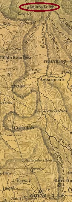
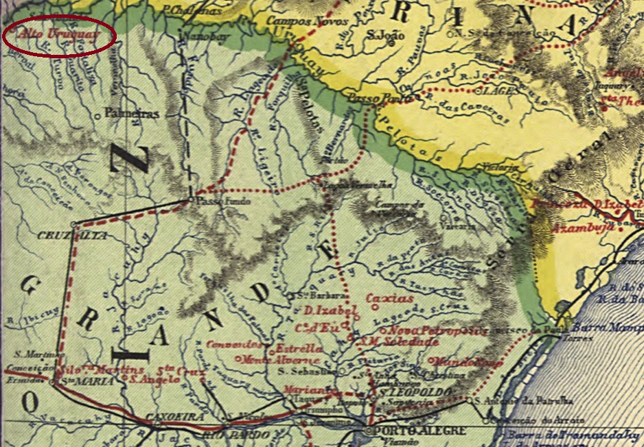
The Freguesia of N. Sra. do Amparo was founded in March 1844 in the Município of Barra Mansa, 150 km northwest of the capital Rio de Janeiro. And so, it has remained to this day, with the freguesia becoming a district in the Republic.

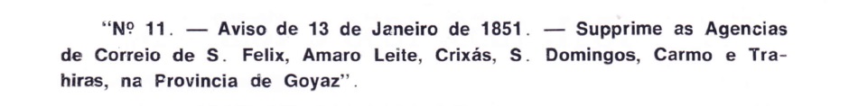
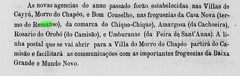
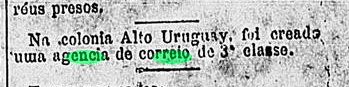
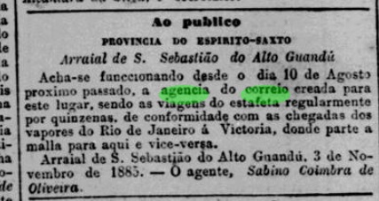
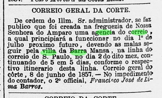
Three periods of operation were found for the local post office in the Empire. For the first time in 1854, as can be read in the Directory of Imperial Post Offices (Tabella das Agencias do Correio do Imperio, Rio de Janeiro, 1885). Then again in June 1857, as shown in the regional press:

Correio Mercantil, 13.06.1857

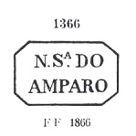
Paulo Novaes writes in agenciaspostais.com.br that the agency was closed in June 1861. It has not yet been possible to determine when the third opening took place, but it must have happened by 1879, because the post office is listed in the Imperial Postal Guide (Guia Postal do Imperio, 1880). The earliest imperial postmark so far is NRJ-1190a, was in circulation between 1857 to at least 1866 and was already presented by Paulo Ayres in Catálogo de Carimbos Brasil-Império (S. Paulo, 1937, 1942) under No. 1366:

NRJ-1190a (P.A. 1366)

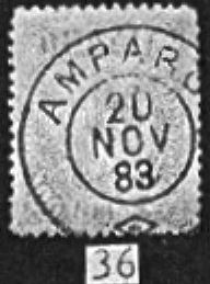
There followed ARJ-0030a, presenting inner dates from 1883 until 1887, as shown by R. Koester in Carimbologia XXVIII:

ARJ-0030a (RK)
Villiers de l’Ile Adam: Carta (…) da Provincia do Rio de Janeiro, 1850

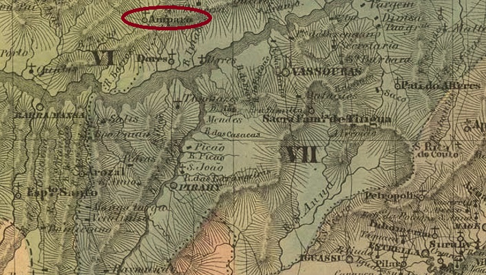
Die Freguesia von N. Sra. do Amparo wurde im März 1844 im Município von Barra Mansa gegründet und lag 150 km nordwestlich der Hauptstadt Rio de Janeiro entfernt. Und so ist es bis heute geblieben, wobei aus der Freguesia in der Republik ein Distrikt wurde.

Drei Betriebsperioden wurden für das örtliche Postamt im Kaiserreich gefunden. Erstmals 1854, wie im Verzeichnis der kaiserlichen Postämter (Tabella das Agencias do Correio do Imperio, Rio de Janeiro, 1885) zu lesen ist. Dann wieder im Juni 1857, wie aus der Regionalpresse hervorgeht:

Correio Mercantil, 13.06.1857

Paulo Novaes schreibt in agenciaspostais.com.br, dass die Agentur im Juni 1861 geschlossen wurde. Bisher konnte nicht ermittelt werden, wann die dritte Eröffnung stattfand, musste aber bis 1879 passiert sein, denn das Postamt ist im kaiserlichen Postführer (Guia Postal do Imperio, 1880) aufgelistet. Der bisher älteste Poststempel im Kaiserzeit ist NRJ-1190a, war im Umlauf zwischen 1857 bis mindestens 1866 und wurde bereits durch Paulo Ayres in Catálogo de Carimbos Brasil-Império (S. Paulo, 1937, 1942) unter der Nr. 1366 vorgestellt:

NRJ-1190a (P.A. 1366)

Ihm folgte ARJ-0030a, der innere Daten zwischen 1883 und 1887 aufweist und bereits durch R. Koester in Carimbologia XXVIII gezeigt wurde:

ARJ-0030a (RK)
Categories
Carimbologia A-B

Ambrosios, Paraná (APR-0005)

Mappa do Estado do Paraná, 1896

Text update of December 30, 2022

Other names: Ambrosio, Tijucas, Aruatã, Tijucas do Sul (1951)

The Freguesia of N. Sra. das Dores dos Ambrosios was founded in 1882 in the Município of S. José dos Pinhais, 60 km south of the provincial capital Curitiba. In the Republic, the place name was changed twice: in October 1938 to Tijucas and in December 1943 to Aruatã. In November 1951, the municipality was emancipated under the name Tijucas do Sul, which is still current today.

The local post office was established in October 1881, according to the Rio de Janeiro press:

Gazeta da Tarde/RJ, 11.10.1881

In the meantime, an older cancel from Ambrosios has appeared: APR-0005a (Coll. Alexandre Andrade) is a double circle with the inscriptions AMBROSIOS above and (PARANÁ) below, found on a numeral issue from 1887. APR-0005b (Coll. Mário Celso Orsi Jr.) now becomes its successor: a double circle with the inscription AMBROSIOS above. The only specimen seen bears the date 1900 in the centre.

Mappa do Estado do Paraná, 1892

Textaktualisierung am 30.12.2022

Andere Namen: Ambrosio, Tijucas, Aruatã, Tijucas do Sul (1951)

Die Freguesia von N. Sra. das Dores dos Ambrosios wurde 1882 im Município von S. José dos Pinhais gegründet und lag 60 km südlich der Provinzhauptstadt Curitiba entfernt. In der Republik wurde der Ortsname zweimal geändert: im Oktober 1938 zu Tijucas und im Dezember 1943 zu Aruatã. Im November 1951 erfolgte die Emanzipation der Gemeinde unter dem heute noch aktuellen Namen Tijucas do Sul.

Das örtliche Postamt wurde im Oktober 1881 ins Leben gerufen, wie die Presse aus Rio de Janeiro mitteilte:

Gazeta da Tarde/RJ, 11.10.1881

Inzwischen ist ein älterer Stempel aus Ambrosios aufgetaucht: APR-0005a (Samml. Alexandre Andrade) ist ein Doppelkreis mit den Inschriften AMBROSIOS oben und (PARANÁ) unten, gefunden auf einer Zifferausgabe aus 1887. APR-0005b (Samml. Mário Celso Orsi Jr.) wird nun sein Nachfolger: ein Doppelkreis mit der Aufschrift AMBROSIOS oben. Das einzige gesehene Exemplar trägt in der Mitte die Jahreszahl 1900.

Categories
Carimbologia A-B

Amarração, Ceará/Piauí (API-0015)

Atlas do Imperio do Brasil, 1868

Text update on July 8, 2025

Another name: Luis Correia (1935)

The freguesia of N. Sra. da Conceição da Amarração was founded in March 1865 and was beautifully situated on the southern delta of the Parnaíba River, 460 km west of the provincial capital Fortaleza. The place was long a point of contention between the provinces of Ceará and Piauí. It rose to the status of vila in August 1874 and was finally assigned to the province of Piauí by imperial decree in October 1880. It was in this town that the first slaves in Piauí province were freed in 1886.

In June 1931, Amarração was downgraded as a district of Parnahyba and called Luís Correia from September 1935. The name is meant to commemorate the Amarração-born jurist and politician Luiz Moraes Correia (1881-1934). Luís Correia has been an independent município since July 1938.

The local post office was created in 1868/69, according to a communication from the Ceará regional postal administration in March 1869:

Administração dos Correios do Ceará, 29/03/1869

A 19th-century postmark from this town has since been seen, the circular cancel API-0015b (Marcio Duarte collection):

API-0015b (MDu) 1882ff
Atlas do Imperio do Brasil, 1868

Textaktualisierung am 08. Juli 2025

Anderer Name: Luis Correia (1935)

Die Freguesia von N. Sra. da Conceição da Amarração wurde im März 1865 gegründet und lag schön am südlichen Delta des Flusses Parnaíba, 460 km westlich der Provinzhauptstadt Fortaleza entfernt. Der Ort war lange ein Streitpunkt zwischen den Provinzen Ceará und Piauí. Er stieg im August 1874 zur Vila auf und wurde im Oktober 1880 durch kaiserlichen Dekret endgültig der Provinz Piauí zugeteilt. In diesem Ort wurden 1886 die ersten Sklaven in der Provinz Piauí befreit.

Im Juni 1931 wurde Amarração als Distrikt von Parnahyba herabgestuft und nannte sich ab September 1935 Luís Correia. Der Name soll an den in Amarração geborenen Juristen und Politiker Luiz Moraes Correia (1881-1934) erinnern. Seit Juli 1938 ist Luís Correia ein eigenständiger Município.

Das örtliche Postamt wurde im Zeitraum 1868/69 ins Leben gerufen, wie aus einer Mitteilung der regionalen Postverwaltung Cearás aus März 1869 hervorgeht:

Administração dos Correios do Ceará, 29.03.1869

Inzwischen wurde ein Poststempel aus dem 19. Jahrhundert aus dieser Ortschaft gesehen, der Kreisstempel API-0015b (Samml. Marcio Duarte):

API-0015b (MDu) 1882ff
Categories
Carimbologia A-B

Amaro Leite, Goiás (AGO-0007)

Atlas do Imperio do Brasil, 1868

Another name: Mara Rosa (1961)

The Freguesia of Sto. Antonio do Amaro Leite was founded in July 1835 in the Municipio of Pilar, close to the Rio do Ouro (Gold River), 320 km north of the former provincial capital of Goyaz (now Goiás Velho). The town changed to the Município of Santana in July 1931 and to the Município de Ururaçu in December 1943. It received its status as an independent Município in August 1953 and has been called Mara Rosa since October 1961. The new name is said to commemorate the two daughters of the bandeirante Amaro Moreira Leite, who is said to have discovered the place in 1742 when he was searching for gold and Indians.

The local post office was already established in March 1829, as Nova Monteiro writes in Administrações e Agencias Postaes do Brasil Imperio (Brasil Filatelico/RJ, 1934-5; Reprint SPP 1994-1999). However, it was already closed in February 1851, as Aureo G. Santos reports in Agências de Correio Criadas e Suprimidas 1851, 1855, 1856 e 1857 (Brasil Filatélico 181, Rio de Janeiro, 1977):

Aureo G. Santos (op. cit)

Since the post office is not listed in the 1880 postal guide (Guia Postal do Imperio) or in the Directory of Imperial Post Offices (Tabella das Agencias do Correio do Imperio, Rio de Janeiro, 1885), we can assume that it was not reopened until 1885, if at all. So far, no postmark from this locality has turned up. It must be very rare.

Villiers de l’Ile Adam: Carta (…) da Provincia de Goayaz, 1849

Anderer Name: Mara Rosa (1961)

Die Freguesia von Sto. Antonio do Amaro Leite wurde im Juli 1835 im Municipio von Pilar gegründet und lag nah am Rio do Ouro (Goldfluss), 320 km nördlich der ehemaligen Provinzhauptstadt Goyaz (heute Goiás Velho) entfernt. Der Ort wechselte im Juli 1931 zum Município von Santana und im Dezember 1943 zum Município de Ururaçu. Er erhielt seinen Status als eigenständiger Município im August 1953 und heißt seit Oktober 1961 Mara Rosa. Der neue Name soll an den beiden Töchtern des Bandeirante Amaro Moreira Leite, der 1742 den Ort entdeckt haben soll, als er auf der Suche nach Gold und Indianern war.

Das örtliche Postamt entstand bereits im März 1829, wie Nova Monteiro in Administrações e Agencias Postaes do Brasil Imperio (Brasil Filatelico/RJ, 1934-5; Reprint SPP 1994-1999) schreibt. Allerdins wurde es bereits im Februar 1851 geschlossen, wie Aureo G. Santos in Agências de Correio Criadas e Suprimidas 1851, 1855, 1856 e 1857 (Brasil Filatélico 181, Rio de Janeiro, 1977) berichtet:

Aureo G. Santos (op. cit)

Da das Postamt weder im Postführer (Guia Postal do Imperio) aus 1880 noch im Verzeichnis der kaiserlichen Postämter (Tabella das Agencias do Correio do Imperio, Rio de Janeiro, 1885) aufgelistet ist, können wir davon ausgehen, dass es erst ab 1885 wieder eröffnet wurde, wenn überhaupt. Bisher ist kein Poststempel aus dieser Ortschaft aufgetaucht. Er muss sehr selten sein.

Categories
Carimbologia A-B

Amargosa, Bahia (ABA-0060)

Atlas do Imperio do Brasil, 1868

The Freguesia of N. Sra. do Bom Conselho de Amargosa was founded in June 1855 at the Vila of Tapera, located on the north bank of the river Jequiriçá-Mirim, 160 km northwest of the provincial capital Salvador da Bahia. It became a vila in April 1877 and a town in June 1891.

Two years of origin for the local post office were found. The first was in 1876, as shown in the report of the Government Council for the Province of Bahia of the following year:

Relatorio do Conselho Interino do Governo da Bahia, 1877

The second year of foundation is 1878, as listed in the Directory of Imperial Post Offices (Tabella das Agencias do Correio do Imperio, Rio de Janeiro, 1885). However, as this agency was not mentioned in the imperial postal guide for 1880 (Guia Postal do Imperio), a third post office opening could have occurred from that year. The only 19th century postmark so far is ABA-0060b (image from the internet): a double circle with the inscription AMARGOSA at the top. The dates in the centre go from 1886 until 1900.

Carta da Republica dos Estados Unidos do Brazil, 1892

Die Freguesia von N. Sra. do Bom Conselho de Amargosa wurde im Juni 1855 bei der Vila von Tapera gegründet und lag am Nordufer des Flusses Jequiriçá-Mirim, 160 km nordwestlich der Provinzhauptstadt Salvador da Bahia entfernt. Der Ort stieg im April 1877 zur Vila und im Juni 1891 zur Stadt auf.

Zwei Entstehungsjahre fürs örtliche Postamt wurden gefunden. Erstmals 1876, wie aus dem Bericht des Regierungsrats für die Provinz Bahia des folgenden Jahres hervorgeht:

Relatorio do Conselho Interino do Governo da Bahia, 1877

Das zweite Gründungsjahr ist 1878, wie im Verzeichnis der kaiserlichen Postämter (Tabella das Agencias do Correio do Imperio, Rio de Janeiro, 1885) aufgelistet. Da aber diese Agentur nicht im kaiserlichen Postführer für 1880 (Guia Postal do Imperio) genannt wurde, könnte eine dritte Postamteröffnung ab dieses Jahr erfolgt sein. Der bisher einzige Poststempel für das 19. Jahrhundert ist ABA-0060b (Abb. aus dem Internet): ein Doppelkreis mit der Inschrift AMARGOSA oben. Die Daten in der Mitte gehen von 1886 bis 1900.

Categories
Carimbologia A-B

Alambary, São Paulo (ASP-0010)

Atlas do Imperio do Brasil, 1868

The chapel of Senhor Bom Jesus do Alambary was built in September 1846 in the Município of Itapetininga, 150 km west of the provincial capital São Paulo. In April 1861, the village was elevated to freguesia status and since December 1991 it has been an independent município, albeit spelled Alambari.

The local post office was established in March 1876, as philatelist Mario Celso Orsi Jr. writes. This is confirmed by the regional press:

Correio Paulistano, 06.04.1876

The imperial postmark ASP-0010a also comes from him: a double circle with the inscription ALAMBARY at the top. There could also be an ornament at the bottom, which unfortunately is not visible in the only specimen (from 1889).

J.M. Ribeiro Lisboa: Provincia de São Paulo, 1884

Die Kapelle von Senhor Bom Jesus do Alambary wurde im September 1846 im Município von Itapetininga errichtet und lag 150 km westlich der Provinzhauptstadt São Paulo entfernt. Im April 1861 wurde der Ort zur Freguesia erhoben und seit Dezember 1991 ist er ein eigenständiger Município, allerdings Alambari geschrieben.

Das örtliche Postamt soll im März 1876 entstanden sein, wie der Philatelist Mario Celso Orsi Jr. schreibt. Dies wird durch die Regionalpresse bestätigt:

Correio Paulistano, 06.04.1876

Aus den Orsi-Notizen stammt auch der kaiserliche Poststempel ASP-0010a: ein Doppelkreis mit der Inschrift ALAMBARY oben. Unten könnte auch ein Ornament sein, das leider im einzigen Exemplar (aus 1889) nicht sichtbar ist.

Categories
Carimbologia A-B

Alto Uruguay, Rio Grande do Sul (ARS-0010)

Mappa do Estado do Rio Grande do Sul, 1891

The military colony of Alto Uruguay was founded in 1879 and was located on the south bank of the Uruguai River in the Municipio of Palmeira on the border with Argentina, 500 km northwest of the provincial capital Porto Alegre. The place and the time were not chosen by chance: after the Triple Alliance War against Paraguay (1864-1870), it was necessary to secure the external borders in the south and southwest. The village changed as a district to the Municipio of Três Passos in December 1944 and since March 1992 it has been a district in the Município of Tiradentes do Sul.

The local post office was created in June 1881, according to the Rio press:

Gazeta de Notícias/RJ, 15/06/1881

The imperial postmark is ARS-0010a (Coll. FM): a double circle with the inscription ALTO=URUGUAY above and an ornament in lozenge below formed by four small lozenges. The previous dates in the centre are from the period 1882-1897.

Carta da Republica dos Estados Unidos do Brazil, 1892

Die Militärkolonie von Alto Uruguay wurde 1879 gegründet und lag am Südufer des Flusses Uruguai im Municipio von Palmeira an der Grenze zu Argentinien, 500 km nordwestich der Provinzhauptstadt Porto Alegre entfernt. Der Ort und der Zeitpunkt waren nicht zufällig gewählt: nach dem Tripelallianz-Krieg gegen Paraguay (1864-1870) galt es, die Außengrenzen im Süden und Südwesten zu sichern. Der Ort wechselte im Dezember 1944 als Distrikt zum Municipio von Três Passos und seit März 1992 ist er ein Distrikt im Município von Tiradentes do Sul.

Das örtliche Postamt entstand im Juni 1881, wie die Presse aus Rio berichtet:

Gazeta de Notícias/RJ, 15.06.1881

Der kaiserliche Poststempel ist ARS-0010a (Samml. FM): ein Doppelkreis mit der Inschrift ALTO=URUGUAY oben und einem Ornament in Raute unten, das aus vier kleinen Rauten gebildet wird. Die bisherigen Daten in der Mitte enttammen dem Zeitraum 1882-1897.

Categories
Carimbologia A-B

Amarante, Piauí (API-0010)

Atlas do Imperio do Brasil, 1868

Another name: São Gonçalo de Amarante

See also São Gonçalo (SPI-0199)

This villa has a long and confused history, which is directly connected both to the current city of Amarante and the old Villa of São Gonçalo. Both villages were one but were separated in 1861 when a large part of the local population, together with the administration, moved to an area closer to the River Parnaíba, located 160 km south of the provincial capital Teresina. The resettlement was called Amarante, and the former S. Gonçalo (S. Gonçalo Velho) became in August 1871 the district of São Gonçalo da Regeneração under Amarante.

As one reads in the Directory of Imperial Post Offices (Tabella das Agencias do Correio do Imperio, Rio de Janeiro, 1885), there had been a post office there since 1880. This date is likely to be a reopening, as the Imperial Postal Guide (Guia Postal do Império do Brazil, Rio de Janeiro, 1880) already listed the agency. Two postmarks were found for the imperial period. API-0010a (illustration from the Internet) is a simple double circle with the inscription AMARANTE at the top and dates in the middle between 1883 and 1892. API-0010b was already presented to us by Paulo Ayres (Catálogo de Carimbos Brasil-Império, S. Paulo, 1937, 1942) on p. 144:

API-0010b (P.A. p. 144)
Carta da Republica dos Estados Unidos do Brazil, 1892

Anderer Name: São Gonçalo de Amarante

Siehe auch São Gonçalo (SPI-0199)

Diese Villa hat eine lange und konfuse Geschichte, die direkt sowohl mit der aktuellen Stadt Amarante als auch mit der alten Villa von São Gonçalo verbunden ist. Beide Ortschaften waren eins, wurden aber 1861 getrennt, als ein Großteil der lokalen Bevölkerung, zusammen mit der Verwaltung, in ein Gebiet näher an den Fluss Parnaíba abzog, 160 km südlich der Provinzhauptstadt Teresina entfernt. Die Umsiedlung wurde Amarante genannt, und die ehemalige S. Gonçalo (S. Gonçalo Velho) wurde im August 1871 in Amarante der Distrikt von São Gonçalo da Regeneração.

Wie man im Verzeichnis der kaiserlichen Postämter (Tabella das Agencias do Correio do Imperio, Rio de Janeiro, 1885) liest, gab es dort ein Postamt seit 1880. Dieses Datum dürfte eine Wiedereröffnung sein, denn im kaiserlichen Postführer (Guia Postal do Império do Brazil, Rio de Janeiro, 1880) wurde die Agentur bereits aufgelistet. Zwei Poststempel wurden für die Kaiserzeit gefunden. API-0010a (Abb. aus dem Internet) ist ein einfacher Doppelkreis mit der Inschrift AMARANTE oben und Daten in der Mitte zwischen 1883 und 1892. API-0010b wurde uns schon von Paulo Ayres (Catálogo de Carimbos Brasil-Império, S. Paulo, 1937, 1942) auf S. 144 vorgestellt:

API-0010b (P.A. S. 144)
Categories
Carimbologia A-B

Alto – Mearim, Maranhão (AMA-0010)

Villiers de l’Ile Adam: Carta (…) da Provincia do Maranhão, 1850

Other names: S. Luiz Gonzaga do Alto Mearim, Ipixuna, S. Luis Gonzaga do Maranhão (1971)

See also São Luiz Gonzaga (SMA-0262)

The freguesia of S. Luiz Gonzaga was founded in August 1844, located in the Município of Itapecuru-Mirim on the east bank of the river Mearim, 250 km south of the provincial capital of São Luís do Maranhão. In June 1854, the village rose to the status of vila. Afterwards, the place name changed twice: in December 1943 to Ipixuna and in October 1971 to S. Luís Gonzaga do Maranhão, which is still current today. The word Ipixuna comes from the Tupi language and means dark waters.

The local post office was established in March 1859, as Nova Monteiro writes in Administrações e Agencias Postaes do Brasil Imperio (Brasil Filatelico/RJ, 1934-5; Reprint SPP 1994-1999). The date is confirmed by the postal report (Relatorio Postal) for 1887. Two postmarks were found for the Empire. AMA-0010a was used from 1859 to 1880 and is already known by Paulo Ayres (Catálogo de Carimbos Brasil-Império, S. Paulo, 1937, 1942) under no. 1195:

AMA-0010a (P.A. 1195)

It was followed by AMA-0010b (image from the internet): a double circle with the inscription ALTO-MEARIM at the top. The dates in the middle have so far been found within the period 1880-1887.

Atlas do Imperio do Brasil, 1868

Andere Namen: S. Luiz Gonzaga do Alto Mearim, Ipixuna, S. Luis Gonzaga do Maranhão (1971)

Siehe auch São Luiz Gonzaga (SMA-0262)

Die Freguesia von S. Luiz Gonzaga wurde im August 1844 gegründet und lag im Município von Itapecuru-Mirim am Ostufer des Flusses Mearim, 250 km südlich der Provinzhauptstadt São Luís do Maranhão entfernt. Im Juni 1854 stieg der Ort zur Vila auf. Danach änderte sich der Ortsname zweimal: im Dezember 1943 zu Ipixuna und im Oktober 1971 zum heute noch aktuellen S. Luís Gonzaga do Maranhão. Das Wort Ipixuna kommt aus der Tupi-Sprache und bedeutet dunkles Gewässer.

Das örtliche Postamt wurde im März 1859 ins Leben gerufen, wie Nova Monteiro in Administrações e Agencias Postaes do Brasil Imperio (Brasil Filatelico/RJ, 1934-5; Reprint SPP 1994-1999) schreibt. Das Datum wird durch den Postbericht (Relatorio Postal) für 1887 bestätigt. Zwei Poststempel wurden fürs Kaiserreich gefunden. AMA-0010a wurde von 1859 bis 1880 verwendet und ist bereits durch Paulo Ayres (Catálogo de Carimbos Brasil-Império, S. Paulo, 1937, 1942) unter Nr. 1195 bekannt geworden:

AMA-0010a (P.A. 1195)

Ihm folgte AMA-0010b (Abb. aus dem Internet): ein Doppelkreis mit der Inschrift ALTO-MEARIM oben. Die Daten in der Mitte wurden bisher innerhalb des Zeitraums 1880-1887 gefunden.

Categories
Carimbologia A-B

Alto Guandu, Espirito Santo (AES-0015)

Briguiet: Mappa do Espirito Santo, 1923

Another name: Afonso Claudio (1890)

The Freguesia of S. Sebastião do Alto Guandú was founded in September 1888, located in the Municipio of Cachoeiro de Sta. Leopoldina on the east bank of the Guandu River, 140 km west of the provincial capital Vitória. In November 1890, the place was declared a Vila with the name Affonso Claudio, in memory of Affonso Claudio de Freitas Rosa (1859-1934), the first Republican Governor of the State of Espirito Santo, who was born in the region. Afonso Claudio (as it is written today) has been a city since November 1907.

As Paulo Novaes writes in agenciaspostais.com.br, there had been a post office there since March 1885, but it did not start operating until August of that year, according to the Rio press:

Jornal do Commercio/RJ, 12.11.1885

The imperial postmark is AES-0015a (agenciaspostais.com.br): a double circle with the inscription CORRO DO ALTO GUANDU above and an ornament below formed by four dots, with internal dates from about 1885 to 1895.

Google Maps

Anderer Name: Afonso Claudio (1890)

Die Freguesia von S. Sebastião do Alto Guandú wurde im September 1888 gegründet und lag im Municipio von Cachoeiro de Sta. Leopoldina am Ostufer des Flusses Guandu, 140 km westlich der Provinzhauptstadt Vitória entfernt. Im November 1890 wurde der Ort zur Vila mit Namen Affonso Claudio erklärt, zum Andenken an Affonso Claudio de Freitas Rosa (1859-1934), dem ersten republikanischen Gouverneur des Staates Espirito Santo, der in der Region geboren war. Seit November 1907 ist Afonso Claudio (wie man es heute schreibt) eine Stadt.

Wie Paulo Novaes in agenciaspostais.com.br schreibt, gab es dort ein Postamt seit März 1885, der allerdings erst im August d.J. den Betrieb aufnahm, wie die Presse aus Rio berichtet:

Jornal do Commercio/RJ, 12.11.1885

Der kaiserliche Poststempel ist AES-0015a (agenciaspostais.com.br): ein Doppelkreis mit der Inschrift CORRO DO ALTO GUANDU oben und einem Ornament unten, das durch vier Punkte gebildet wird, mit internen Daten von ca. 1885 bis 1895.