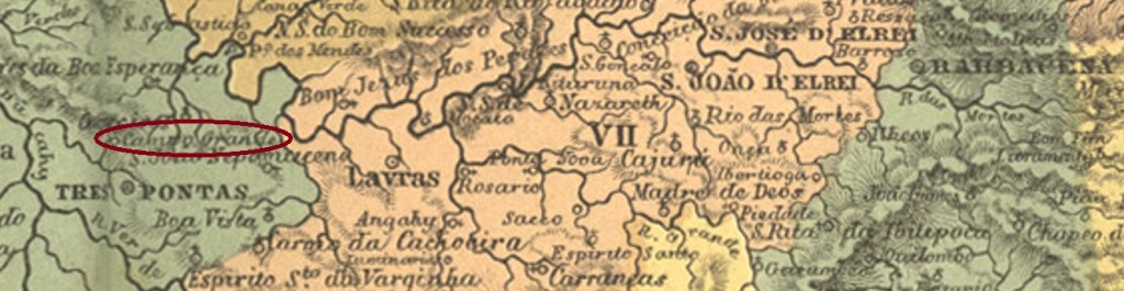
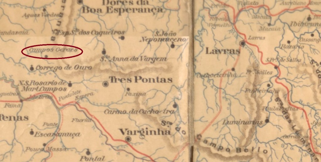
Other names: Carmo do Campo Grande, Campos Gerais (1901)
The freguesia of Carmo do Campo Grande was founded as early as September 1870 at the Vila of Tres Pontas and was located directly on the Divisa (border) stream. This actually represented the border between two hostile family estates in the region, 350 km southwest of the provincial capital Ouro Preto. In September 1901, it became the Vila of Campos Gerais, which has been a town since September 1915.
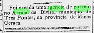
There had been a post office there since October 1883, as reported by the Rio press:
Gazeta da Tarde/RJ, 25/10/1883
So far, no imperial postmark has been sighted from this place.
Estado de Minas Geraes, 1910
Andere Namen: Carmo do Campo Grande, Campos Gerais (1901)
Die Freguesia von Carmo do Campo Grande wurde bereits im September 1870 bei der Vila von Tres Pontas gegründet und lag direkt am Bach Divisa (Grenze). Dieser stellte tatsächlich die Grenze zwischen zwei verfeindeten Familienbesitzen der Region dar, 350 km südwestlich der Provinzhauptstadt Ouro Preto entfernt. Im September 1901 wurde daraus die Vila von Campos Gerais, die seit September 1915 eine Stadt ist.
Dort gab es ein Postamt seit Oktober 1883, wie die Presse aus Rio meldete:
Gazeta da Tarde/RJ, 25.10.1883
Bisher wurde kein kaiserlicher Poststempel aus diesem Ort gesichtet.
Other names: Arraial do Tatu, Itapexirica, Estrada Nova.
See also Conceição da Estrada Nova (Koester: Carimbologia XIII)
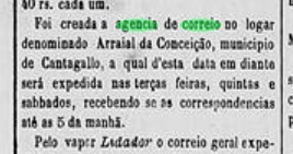
This settlement was originally called Arraial do Tatu or Itapexirica and was located near Cantagallo, 240 km northeast of the capital Rio de Janeiro. In 1859 it was renamed N. Sa. da Conceição da Estrada Nova, and in September 1890 it became a district, changing to the newly created Município of Itaocara the following month. Finally, in November 1924, the district was given the simplified name of Estrada Nova.
The local post office was established in December 1873, as reported by the regional press:
A Reforma, 06.12.1873
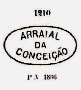
The first postmark is ARJ-0065a, which also exists in brown, blue, green and dark purple. It was in use until about 1879 and is already known by Paulo Ayres (Catálogo de Carimbos Brasil-Império, S. Paulo, 1937, 1942) under No. 1210:
ARJ-0065a (P.A. 1210, MPT 351)
Later postmarks (from c. 1881) bear the place name Estrada Nova and were already presented by R. Koester in Carimbologia XIII.
agenciaspostais.com.br
Andere Namen: Arraial do Tatu, Itapexirica, Estrada Nova
Siehe auch Conceição da Estrada Nova (Koester: Carimbologia XIII)
Diese Siedlung hieß ursprünglich Arraial do Tatu bzw. Itapexirica und lag bei Cantagallo, 240 km nordöstlich der Hauptstadt Rio de Janeiro entfernt. 1859 erfolgte eine Umbenennung zu N. Sa. da Conceição da Estrada Nova, und im September 1890 wurde daraus ein Distrikt, der im darauffolgenden Monat zum neu gegründeten Município von Itaocara wechselte. Schließlich erhielt der Distrikt im November 1924 den verinfachten Namen Estrada Nova.
Das örtliche Postamt wurde im Dezember 1873 ins Leben gerufen, wie die Regionalpresse meldete:
A Reforma, 06.12.1873
Der erste Poststempel ist ARJ-0065a, den es auch in braun, blau, grün und dunkelviolett gibt. Er war bis ca. 1879 in Verwendung und ist bereits durch Paulo Ayres (Catálogo de Carimbos Brasil-Império, S. Paulo, 1937, 1942) unter Nr. 1210 bekannt:
ARJ-0065a (P.A. 1210, MPT 351)
Spätere Poststempel (ab ca. 1881) tragen den Ortsnamen Estrada Nova und wurden bereits durch R. Koester in Carimbologia XIII vorgestellt.
This post office presents another enigma. There is no entry under this name in the press, but the agency is listed in the Imperial Postal Guide (Guia Postal do Império, 1880) under No. 63 and according to Paulo Novaes (agenciaspostais.com.br) it is said to have been in operation between about 1879 and about 1889. However, there is nothing about it in the Directory of Imperial Post Offices (Tabella das Agencias do Correio do Imperio, Rio de Janeiro, 1885). Why?
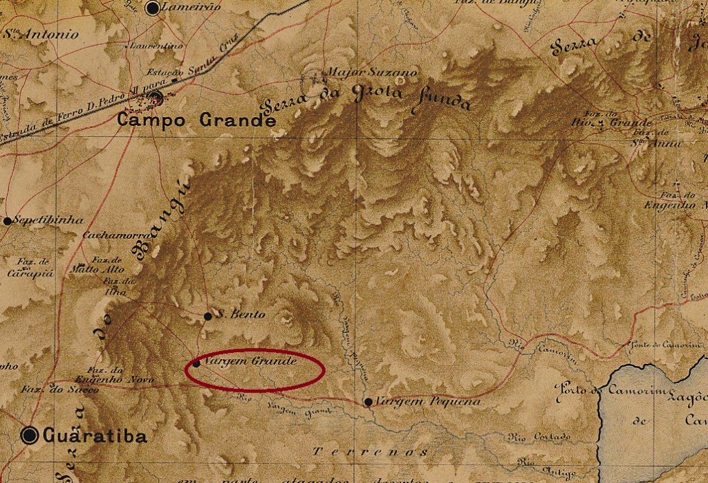
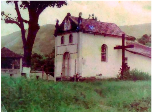
My hypothesis: the post office is identical with the agency in Vargem Grande of Guaratiba (VMN-0205). The latter is mentioned in the Directory of 1885 as having been established in 1879, but is missing from the Postal Guide of 1880. Moreover, from 1827 to about 1985, there was a chapel in honour of St. Sebastian in Vargem Grande:
ecomuseusertaocarioca.blogspot.com
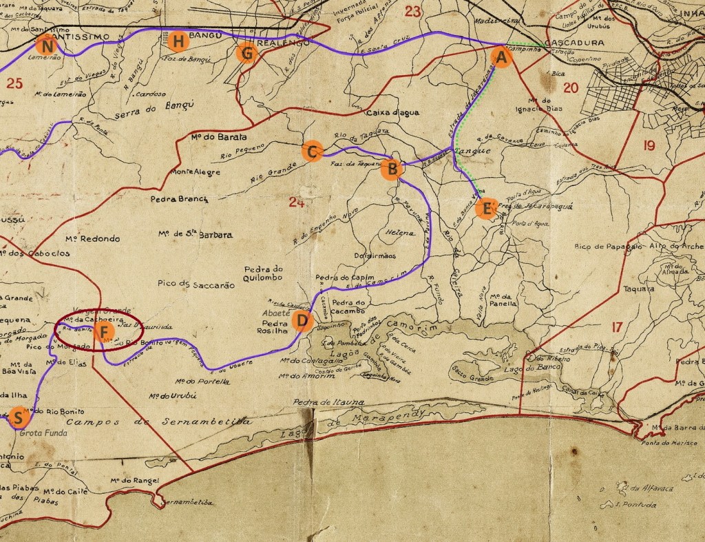
It seems very unlikely that such a tiny suburb had two active post offices next to each other at the same time. The settlement originated as a large fazenda more than 40 km west of the capital Rio de Janeiro. It belonged to the freguesia of Guaratiba and was separated from this locality by the Serra do Bangu. Today, Vargem Grande is part of the district of Barra da Tijuca in the município of Rio de Janeiro.
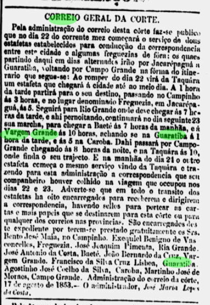
From August 1853 onwards, there was both a postal relay service there and stamp sales on place, according to the Rio press:
Jornal do Commercio 18.08.1853
So far, no Imperial postmark has been seen for this locality.
Mappa do Distrito Federal, 1920 ( in agenciaspostais.com.br)
Anderer Name: Campo da Capella
Siehe auch Vargem Grande (VMN-0205)
Auch dieses Postamt stellt einen Rätsel dar. Unter diesem Namen findet sich keine Eintragung in der Presse, aber die Agentur ist im kaiserlichen Postführer (Guia Postal do Império, 1880) unter Nr. 63 aufgelistet und soll laut Paulo Novaes (agenciaspostais.com.br) zwischen ca. 1879 und ca. 1889 in Betrieb gewesen sein. Allerdings findet sich nichts darüber im Verzeichnis der kaiserlichen Postämter (Tabella das Agencias do Correio do Imperio, Rio de Janeiro, 1885). Warum?
Meine Hypothese: das Postamt ist identisch mit der Agentur in Vargem Grande von Guaratiba (VMN-0205). Denn letztere wird im Verzeichnis (1885) mit Entstehungsjahr 1879 genannt, fehlt aber im Postführer aus 1880. Außerdem gab es von 1827 bis ca. 1985 in Vargem Grande eine Kapelle zum Ehren vom Hl. Sebastian:
ecomuseusertaocarioca.blogspot.com
Es scheint sehr unwahrscheinlich, dass so ein winziger Vorort damals zur gleichen Zeit zwei aktive Postämter nebeneinander hatte. Die Siedlung entstand als eine große Fazenda, die über 40 km westlich von der Hauptstadt Rio de Janeiro entfernt lag. Sie gehörte der Freguesia von Guaratiba und war von dieser Ortschaft durch die Serra do Bangu getrennt. Heute ist Vargem Grande ein Ortsteil des Distrikts von Barra da Tijuca im Município von Rio de Janeiro.
Es gab ab August 1853 sowohl einen Poststafettendienst dorthin als auch Briefmarkenverkauf vor Ort, wie die Presse aus Rio mitteilte:
Jornal do Commercio 18.08.1853
Bisher wurde kein Poststempel des Kaiserreichs für diese Ortschaft gesehen.
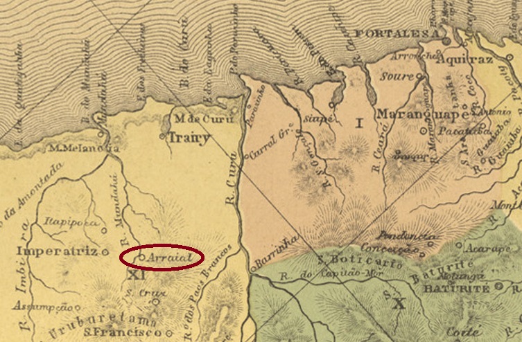
Other names: S. João da Imperatriz, Uruburetama (1938)
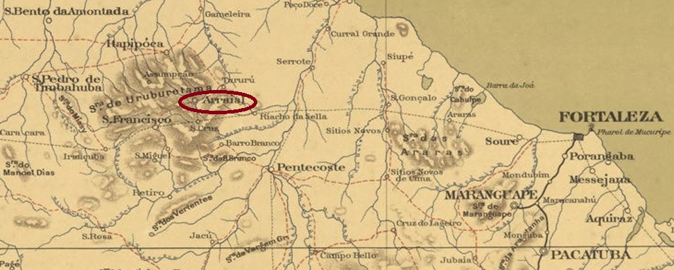
The Portuguese word Arraial actually means small settlement, neither a freguesia nor a vila. But semantics do not matter for this village on the north bank of the Mundaú River, 120 km west of Fortaleza. It became a district in the Município of São Francisco in September 1869, changed as a freguesia to the Município of S. João da Imperatriz (today: Itapipoca) in December 1885 and became an independent vila (called Arraial) in August 1890. This status was lost eight years later: Arraial became a district of São Francisco again. After that, the place name changed three times: in August 1899 – again as Município – to S. João de Uruburetama, in May 1931 again to Arraial, and finally in December 1938 to Uruburetama, which is still valid today. The Tupi word means land of vultures. Better to be called Arraial then…
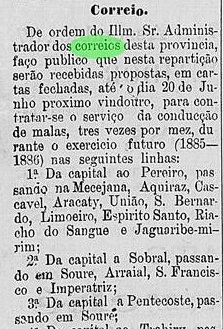
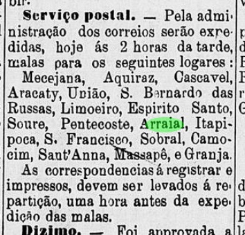
It is not certain whether the place had an imperial post office, but evidence suggests it did. In the Directory of Imperial Post Offices (Tabella das Agencias do Correio do Imperio, Rio de Janeiro, 1885), no agency was listed there, but in the same year 1885, a forthcoming postal route through Arraial was announced in the regional press:
A Constituição, 21.05.1885
And also in July 1890 – i.e., in the early Republic – there were reported regular postal routes to and from Arraial:
Cearense, 03.07.1890
Until now, no imperial postmark has turned up.
Serviço Geologico e Mineralogico do Brasil, 1910
Andere Namen: S. João da Imperatriz, Uruburetama (1938)
Das portugiesische Wort Arraial bedeutet eigentlich kleine Siedlung, also weder eine Freguesia noch einer Vila. Aber die Semantik spielt keine Rolle bei dieser Ortschaft am Nordufer des Flusses Mundaú, 120 km westlich von Fortaleza gelegen. Sie wurde im September 1869 zum Distrikt im Município von São Francisco, wechselte als Freguesia im Dezember 1885 zur Município von S. João da Imperatriz (heute: Itapipoca) und wurde eine eigenständige Vila (mit Namen Arraial) im August 1890. Dieser Status ging acht Jahre später verloren: Arraial wurde wieder ein Distrikt von São Francisco. Danach wechselte der Ortsname dreimal: im August 1899 – wieder als Município – zu S. João de Uruburetama, im Mai 1931 wieder zu Arraial, und schließlich im Dezember 1938 zum heute noch gültigen Uruburetama. Der Begriff der Tupi-Sprache bedeutet Land der Geier. Dann doch lieber Arraial heißen…
Es ist nicht sicher, ob der Ort ein kaiserliches Postamt hatte, aber die Indizien sprechen eher dafür. Im Verzeichnis der kaiserlichen Postämter (Tabella das Agencias do Correio do Imperio, Rio de Janeiro, 1885) war keine Agentur dort aufgelistet, aber im gleichen Jahr 1885 waren Postrouten durch Arraial in der Regionalpresse angekündigt:
A Constituição, 21.05.1885
Und auch im Juli 1890 – also in der frühen Republik – waren regulären Postlinien von und nach Arraial vorhanden:
Cearense, 03.07.1890
Nun ist bisher kein kaiserlicher Poststempel aufgetaucht.
Villiers de l’Ile Adam: Carta (…) da Provincia do Ceara, 1849
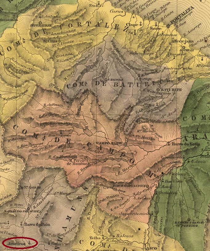
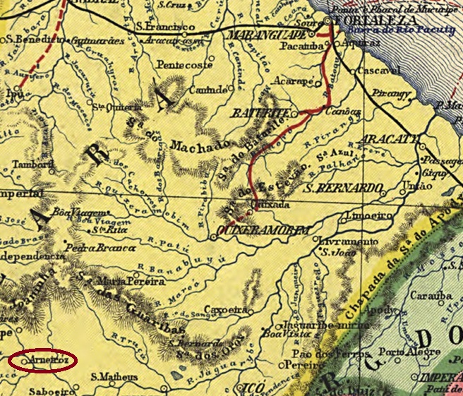
The Freguesia of Arneiroz was established in August 1784 and was located at the Vila of Quixeramobim on the south bank of the river Jaguaribe, more than 380 km southwest of the provincial capital Fortaleza. It was declared a vila in November 1864 but lost this status in May 1931 and became a district of the municipality of Tauá. Since March 1957, Arneiroz has once again been an independent município. The name recalls a Portuguese freguesia near Lamego in the district of Viseu.
The local post office was created in 1874, according to the Directory of Imperial Post Offices (Tabella das Agencias do Correio do Imperio, Rio de Janeiro, 1885), and closed in April 1891, according to the Postal Bulletin (Boletim Postal) of that year. No imperial postmark from this locality has been found so far.
Carta da Republica dos Estados Unidos do Brazil, 1892
Die Freguesia von Arneiroz wurde im August 1784 errichtet und lag bei der Vila von Quixeramobim am Südufer des Flusses Jaguaribe, über 380 km südwestlich der Provinzhauptstadt Fortaleza entfernt. Sie wurde im November 1864 zur Vila erklärt, verlor aber diesen Status im Mai 1931 und wurde ein Distrikt der Gemeinde Tauá. Seit März 1957 ist Arneiroz wieder ein eigenständiger Município. Der Name erinnert an einer portugiesischen Freguesia bei Lamego im Bezirk Viseu.
Das örtliche Postamt wurde 1874 ins Leben gerufen, wie im Verzeichnis der kaiserlichen Postämter (Tabelladas Agencias do Correio do Imperio, Rio de Janeiro, 1885) zu lesen ist, schloss aber im April 1891, wie der Postbulletin (Boletim Postal) d. Jh. berichtet. Bisher wurde kein kaiserlicher Poststempel aus dieser Ortschaft gefunden.
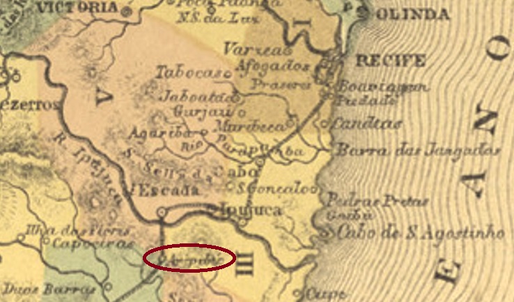
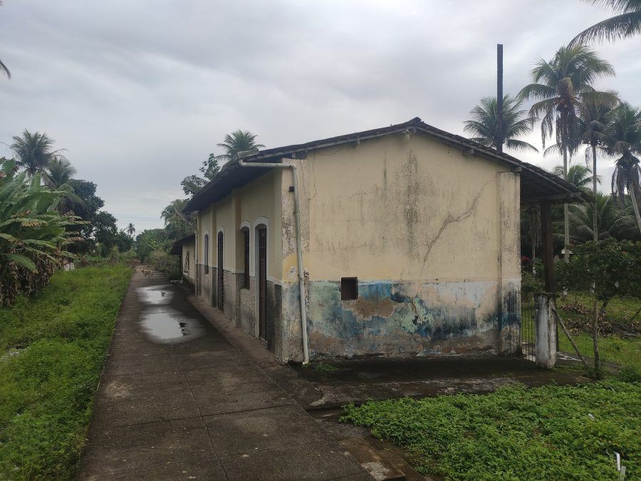
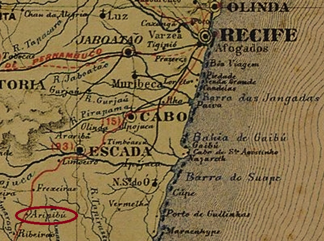
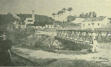
Aripibú station was inaugurated in May 1862 by the E.F. do Recife ao São Francisco (Southern Line) railway company and was located directly on the Engenho (sugar cane plantation) Aripibú in the Município of Escada, 75 km southwest of the provincial capital Recife. The railway line went to the Great Western company in 1901, to Rede Ferroviária do Nordeste in 1950 and from 1975 until its closure in 1996 it belonged to Rede Ferroviária Federal S.A. (estacoesferroviarias.com.br). Today, the rails are gone and the station building serves as a residence for the widow of the last stationmaster.
1906 (O Malho, after estacoesferroviarias.com.br)2022 (Photo: Rodrigo Henrique, after estacoesferroviarias.com.br)
The settlement around the station continued to grow slowly and from November 1889 it belonged to the Vila of Amaracy, which has been called Amaragy since September 1890. Since December 1938, the station has been in the Município of Ribeirão.
Three dates of origin have been found for the station post office. The first was in December 1864, according to the Rio press:
Constitucional/RJ, 21.12.1864
Then again in June 1875, as reported by the regional press:
Diario de Pernambuco, 10.06.1875
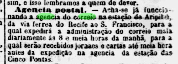
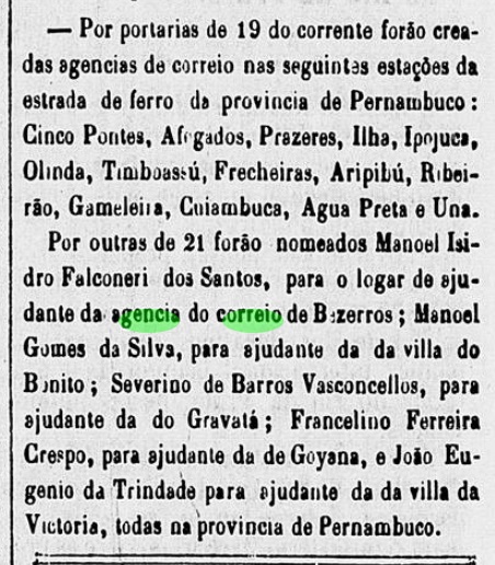
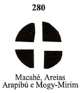
The third date of creation of the agency would be around 1879, since this creation was mentioned on page VI of the Empire’s Postal Guide (Guia Postal do Império), published at the end of that year. A station and a mute postmark have also been recorded. APE-0055b (Coll. Roberto Assef Jr.) is a French type, with the above inscription ESTÇÃO ARIPIBÚ and the star between brackets at the bottom. The dates in the centre – mostly written by hand – go from 1881 to 1888.
The mute postmark has already been presented by James Dingler and Klerman W. Lopes in Mute Cancellations of the Brazil Empire / Carimbos Mudos do Brasil Império (Brazil Philatelic Association, Rio de Janeiro, 2000) under No. 280:
BPA 280Carta Corographica da Provincia de Pernambuco, 1880
Anderer Name: Arapibú
Der Bahnhof Aripibú wurde im Mai 1862 durch die Bahngesellschaft E.F. do Recife ao São Francisco (Südlinie) eingeweiht und lag direkt am Engenho (Zuckerrohrplantage) Aripibú im Município von Escada, 75 km südwestlich der Provinzhauptstadt Recife entfernt. Die Bahnlinie ging 1901 zur Great Western-Gesellschaft, 1950 zur Rede Ferroviária do Nordeste und von 1975 bis zur Stilllegung 1996 gehörte sie der Rede Ferroviária Federal S.A. (estacoesferroviarias.com.br). Heute sind die Schienen weg, und das Bahnhofsgebäude dient als Wohnhaus für die Witwe des letzten Bahnvorstehers.
1906 (O Malho, nach estacoesferroviarias.com.br)2022 (Foto: Rodrigo Henrique, nach estacoesferroviarias.com.br)
Die Siedlung um den Bahnhof wuchs langsam weiter und gehörte ab November 1889 zur Vila von Amaracy, die seit September 1890 Amaragy heißt. Seit Dezember 1938 liegt der Bahnhof im Município von Ribeirão.
Es wurden drei Entstehungsdaten fürs Bahnhofspostamt gefunden. Erstmals im Dezember 1864, wie die Presse aus Rio mitteilte:
Constitucional/RJ, 21.12.1864
Dann wieder im Juni 1875, wie aus der Regionalpresse hervorgeht:
Diario de Pernambuco, 10.06.1875
Das dritte Datum der Gründung der Agentur wäre um 1879, da diese Neugründung auf Seite VI des am Ende des Jahres veröffentlichten Kaiserlichen Postführer (Guia Postal do Império) erwähnt wurde. Ein Bahnhofs- und ein stummer Stempel sind auch erfasst worden. APE-0055b (Samml. Roberto Assef Jr.) ist ein Französischer Typus, mit der obigen Inschrift ESTÇÃO ARIPIBÚ und dem Stern zwischen Klammern unten. Die Daten in der Mitte – meistens per Hand eingetragen gehen von 1881 bis 1888.
Der stumme Poststempel wurde bereits durch James Dingler und Klerman W. Lopes in Mute Cancellations of the Brazil Empire / Carimbos Mudos do Brasil Império (Brazil Philatelic Association, Rio de Janeiro, 2000) unter Nr. 280 vorgestellt:
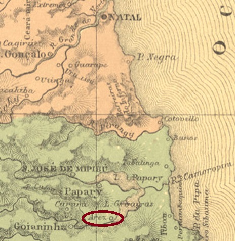
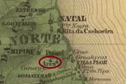
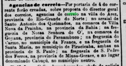
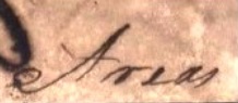
Vila Nova de Arez was founded as early as September 1758 and was located on the western shore of Lake Guaraíras, 60 km south of the future provincial capital Natal. In August 1821, it was downgraded to a freguesia of the Vila of Goianinha and even lost this status 11 years later. A brief resurgence to vila (August 1855 – April 1862) was followed by relegation to freguesia again. It was not until December 1876 that Arês – as it is written today – finally became an independent município. The name is reminiscent of a small village in the Upper Alentejo in Portugal, with 256 inhabitants in 2011.
The local post office was established in May 1882, as the Rio press writes:
Jornal do Commercio/RJ, 06.05.1882
So far, no imperial-era postmark has been sighted from this locality.
Villiers de l’Ile Adam: Carta (…) das Provincias do Rio Grande do Norte e Parahiba, 1848
Andere Namen: Guaraíras, Arês
Die Vila Nova de Arez wurde bereits im September 1758 gegründet und lag am Westufer des Guaraíras-Sees, 60 km südlich der späteren Provinzhauptstadt Natal entfernt. Im August 1821 wurde der Ort zu einer Freguesia der Vila von Goianinha herabgestuft und verlor 11 Jahre später sogar diesen Freguesia-Status. Einem kurzen Wiederaufstieg zur Vila (August 1855-April 1862) folgte wieder den Abstieg zur Freguesia. Erst ab Dezember 1876 ist Arês – wie man es heute schreibt – endgültig ein eigenständiger Município. Der Name erinnert an einer kleinen Gemeinde im Oberen Alentejo in Portugal, mit 256 Einwohnern im Jahre 2011.
Das örtliche Postamt entstand im Mai 1882, wie die Presse aus Rio schreibt:
Jornal do Commercio/RJ, 06.05.1882
Bisher wurde kein Poststempel der Kaiserzeit aus dieser Ortschaft gesichtet.
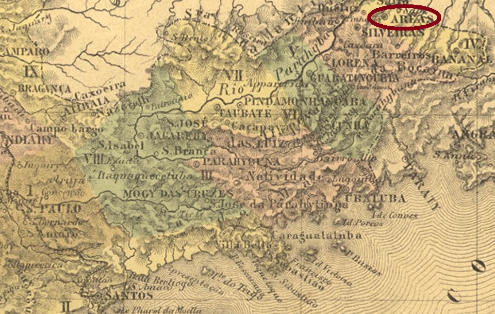
Villiers de l’Ile Adam: Carta (…) da Provincia de São Paulo, 1847
Other names: Sant’Anna da Parahyba Nova
See also Villa de Areias (VSP-1765)
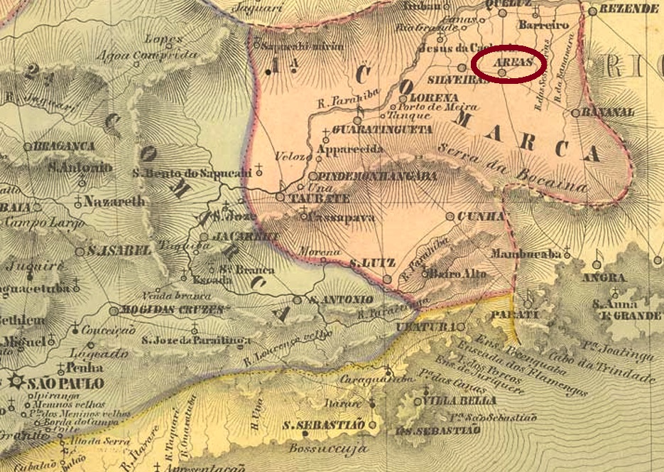
The freguesia of Sant’Anna da Parahyba Nova was created in January 1784 on the south bank of the river Parahyba do Sul, barely 250 km northeast of the future provincial capital of São Paulo. In 1801, the village became a freguesia of the Vila of Lorena, and in November 1816, it became a vila with the name São Miguel das Areias. Areias has been a town since March 1857.
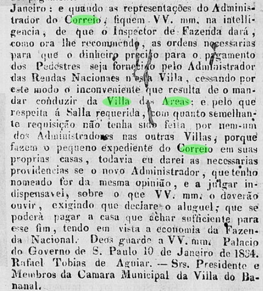
The local post office was created in December 1847, according to Nova Monteiro (Administrações e Agencias Postaes do Brasil Imperio, in Brasil Filatelico/RJ, 1934-5; Reprint SPP 1994-1999). Nevertheless, both letters with earlier dates and press releases of the 1830s suggest that a postal service, however organised, was active there before that year:
O Novo Farol Paulistano, 07.02.1834
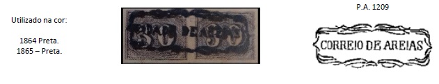
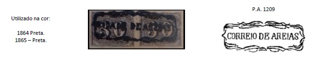
The first postal cancellation with Areia is ASP-1520a. This was used at least between 1864 and 1865 and was already presented by Paulo Ayres (Catálogo de Carimbos Brasil-Império, S. Paulo, 1937, 1942) under No. 1209. However, the illustration is faulty, as it can be seen here:
ASP-1520a (P.A. 1209 -recte, MO)
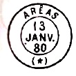
The following cancel ASP-1520b, a French type, was also found in blue, in use through the period 1868-1880 and was also shown by Paulo Ayres (op. cit.), this time on page 117:
ASP-1520b (P.A. p. 117)
After it there came an imitation, ASP-1520c (image from the internet), which also shows the star between brackets at the bottom. However, the letters at the top are larger. The dates in the middle go from 1885 to 1898.
A mute cancellation found on a letter from 1874 was registered by James Dingler and Klerman W. Lopes in Mute Cancellations of the Brazil Empire / Carimbos Mudos do Brasil Império (Brazil Philatelic Association, Rio de Janeiro, 2000) under no. 280:
BPA 280, 1874
From 1835 there was also a handwritten cancellation from Areias:
1835 (Image by Mário Celso Orsi Jr.)
For place stamps with VILLA DE AREIAS or VILLA DE AREAS see VSP-1765.
Atlas do Imperio do Brasil, 1868
Anderer Namen: Sant’Anna da Parahyba Nova
Siehe auch Villa de Areias (VSP-1765)
Die Freguesia von Sant’Anna da Parahyba Nova entstand im Januar 1784 und lag am Südufer des Flusses Parahyba do Sul, knapp 250 km nordöstlich der späteren Provinzhauptstadt São Paulo entfernt. 1801 ging die Ortschaft als Freguesia zur Vila von Lorena und wurde selber im November 1816 eine Vila mit Namen São Miguel das Areias. Seit März 1857 ist Areias eine Stadt.
Das örtliche Postamt entstand laut Nova Monteiro (Administrações e Agencias Postaes do Brasil Imperio, in Brasil Filatelico/RJ, 1934-5; Reprint SPP 1994-1999) im Dezember 1847. Dennoch, sowohl Briefe mit früheren Daten als auch Pressenachrichten der 1830er Jahre legen nahe, dass es dort ein wie auch immer organisierten Postbetrieb bereits vorher aktiv war:
O Novo Farol Paulistano, 07.02.1834
Die erste postalische Entwertung mit Areia ist ASP-1520a. Diese war nachweislich zwischen 1864 und 1865 verwendet und wurde bereits durch Paulo Ayres (Catálogo de Carimbos Brasil-Império, S. Paulo, 1937, 1942) unter Nr. 1209 vorgestellt. Allerdings ist die Abbildung fehlerhaft, wie man hier feststellen kann:
ASP-1520a (P.A. 1209 –recte, MO)
Der Nachfolgestempel ASP-1520b, ein Französischer Typus, war auch Blau anzutreffen, 1868-1880 in Verwendung und wurde ebenfalls durch Paulo Ayres (op. cit.) diesmal auf Seite 117 gezeigt:
ASP-1520b (P.A. p./S. 117)
Nach ihm kam eine Nachahmung, ASP-1520c (Abb. aus dem Internet), der auch den Stern zwischen Klammern unten zeigt. Allerdings sind die Buchstaben oben größer. Die Daten in der Mitte gehen von 1885 bis 1898.
Eine stumme Abstempelung, gefunden auf einem Brief aus 1874, wurde durch James Dingler und Klerman W. Lopes in Mute Cancellations of the Brazil Empire / Carimbos Mudos do Brasil Império, (Brazil Philatelic Association, Rio de Janeiro, 2000) unter Nr. 280 registriert:
BPA 280, 1874
Aus 1835 kam auch eine handschriftliche Entwertung aus Areias:
1835 (Abb. Mário Celso Orsi Jr.)
Für Ortsstempel mit VILLA DE AREIAS oder VILLA DE AREAS siehe VSP-1765.
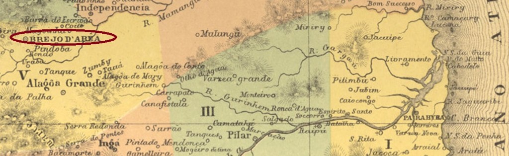
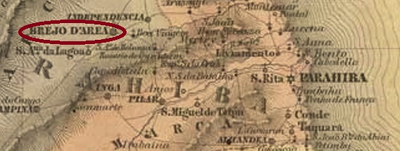
See also Brejo d’Area (R. Koester: Carimbologia VI)
The freguesia of N. Sa. da Conceição do Brejod’Area was founded in June 1813 and was located at the Vila of Monte-Mor (today: Mamanguape), 130 km west of the later provincial capital of Parahyba do Norte (today: João Pessoa). Two years later, the place became the Vila of Brejo d’Area, and since May 1846 it has been a town, simply called Areia (Sand) until nowadays.
As Nova Monteiro writes in Administrações e Agencias Postaes do Brasil Imperio (Brasil Filatelico/RJ, 1934-5; Reprint SPP 1994-1999), there was a post office there as early as May 1829. The only imperial-era postmark from this locality so far is APB-0040b (image from the internet). In this French type, AREIA is read at the top and the small star appears between brackets at the bottom. The dates inside – if there is any – go from 1881 to at least 1894.
Villiers de l’Ile Adam: Carta (…) das Provincias do Rio Grande do Norte e Parahiba, 1848
Siehe auch Brejo d’Area (R. Koester: Carimbologia VI)
Die Freguesia von N. Sa. da Conceição do Brejod’Area wurde im Juni 1813 gegründet und lag bei der Vila von Monte-Mor (heute: Mamanguape), 130 km westlich der späteren Provinzhauptstadt Parahyba do Norte (heute: João Pessoa) entfernt. Zwei Jahre später wurde der Ort zur Vila von Brejo d’Area, und seit Mai 1846 ist er eine Stadt, die bis heute einfach Areia (Sand) heißt.
Wie Nova Monteiro in Administrações e Agencias Postaes do Brasil Imperio (Brasil Filatelico/RJ, 1934-5; Reprint SPP 1994-1999) schreibt, gab es dort ein Postamt bereits ab Mai 1829. Der bisher einzige Poststempel der Kaiserzeit aus dieser Ortschaft ist APB-0040b (Abb. aus dem Internet). In diesem französischen Typus liest man AREIA oben und unten erscheint der kleine Stern zwischen Klammern. Die Daten im Inneren – wenn überhaupt vorhanden – gehen von 1881 bis mindestens 1894.
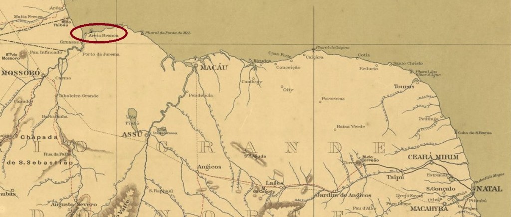
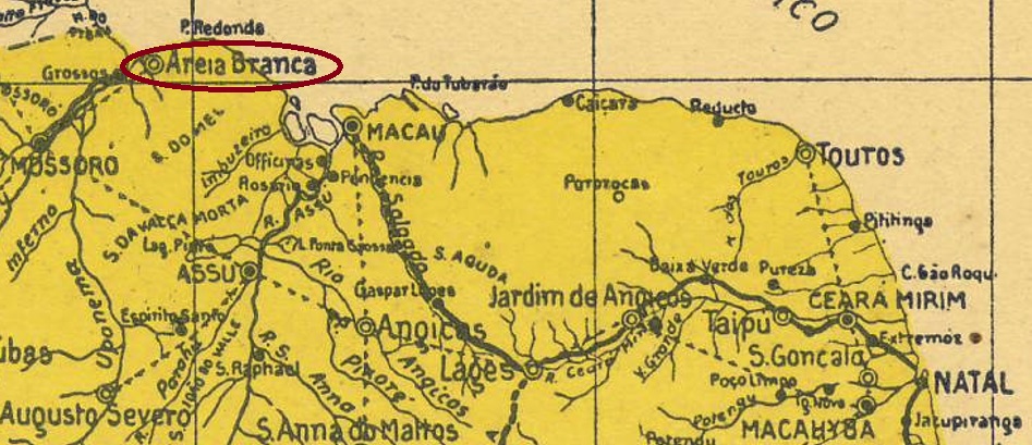
Areia Branca (White Sand) was the name of the freguesia of the Vila of Mossoró, founded in December 1872 on the eastern bank of the Apodi River, close to its delta, barely 300 km west of the provincial capital Natal. The place was downgraded to a povoação four years later but was granted vila status in February 1892. Areia Branca has been a town since October 1927.
Two dates of origin for the local post office have been found. Reinhold Koester writes June 1872 for it in Carimbologia II, while the regional press does not report the new postal clerk until 1889:
Gazeta de Natal, 19.12.1889
Since the post office is not listed in the Directory of Imperial Post Offices (Tabella das Agencias do Correio do Imperio, Rio de Janeiro, 1885), we can assume at least two periods of operation, should Koester be correct. So far, no imperial-era postmark has been sighted from this locality.
Arthur D. Ribeiro, Estado do Rio Grande do Norte, 1923
Areia Branca (Weißer Sand) hieß die Freguesia der Vila von Mossoró, die im Dezember 1872 am Ostufer des Flusses Apodi gegründet wurde und nah an dessen Delta lag, knapp 300 km westlich der Provinzhauptstadt Natal. Der Ort wurde vier Jahre später zu einer Povoação herabgestuft, erhielt aber im Februar 1892 den Status einer Vila. Seit Oktober 1927 ist Areia Branca eine Stadt.
Zwei Entstehungsdaten fürs örtliche Postamt wurden gefunden. Reinhold Koester schreibt dafür den Juni 1872 in Carimbologia II, während die Regionalpresse erst 1889 über einen neuen Postangestellten berichtet:
Gazeta de Natal, 19.12.1889
Da das Postamt nicht im Verzeichnis der kaiserlichen Postämter (Tabella das Agencias do Correio do Imperio, Rio de Janeiro, 1885) aufgelistet ist, können wir von mindestens zwei Betriebsperioden ausgehen, sollte Koester richtig liegen. Bisher wurde kein Poststempel der Kaiserzeit aus dieser Ortschaft gesichtet.