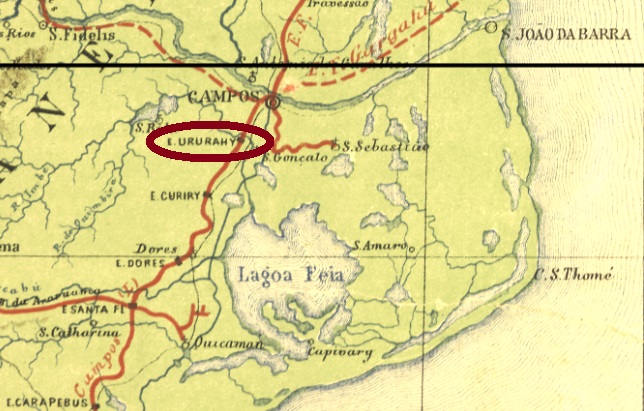
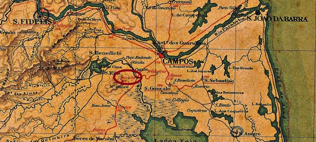
Ururahy station was inaugurated around 1875 by the Estrada de Ferro de Macahe a Campos railway company and was located on the east bank of the river of the same name in the Município of Campos, 260 km northeast of the capital Rio de Janeiro. The railway line became part of the Estrada de Ferro Leopoldina in 1887 and from 1975 until its closure in 1996 it belonged to Rede Ferroviária Federal S.A. (estacoesferroviarias.com.br). Around 1945, the station and town name changed to Cupim, which is now a rural suburb southwest of Campos dos Goytacazes.
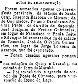
According to the Rio press, there was a post office at the station from September 1889:
Diario do Commercio, 20.09.1889
So far, no imperial-era postmark has been seen from this station.
Almanak Laemmert, 1892
Anderer Name: Cupim
Der Bahnhof Ururahy wurde um 1875 durch die Estrada de Ferro de Macahe a Campos Bahngesellschaft eingeweiht und lag am Ostufer des gleichnamigen Flusses im Município von Campos, 260 km nordöstlich der Hauptstadt Rio de Janeiro entfernt. Die Bahnlinie ging 1887 zur Estrada de Ferro Leopoldina über und von 1975 bis zur Stilllegung 1996 gehörte sie der Rede Ferroviária Federal S.A. (estacoesferroviarias.com.br). Gegen 1945 wechselten der Bahnhofs- und Ortsname zu Cupim, der heute ein ländlicher Vorort südwestlich von Campos dos Goytacazes ist.
Wie aus der Rio-Presse zu entnehmen ist, gab es ein Postamt am Bahnhof seit September 1889:
Diario do Commercio, 20.09.1889
Bisher war kein Poststempel aus der Kaiserzeit aus diesem Bahnhof zu sehen.
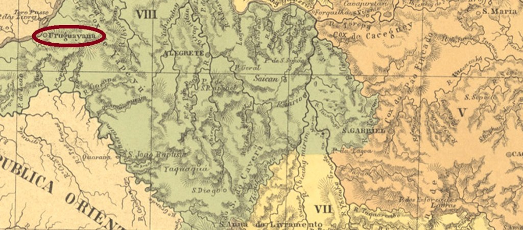
Other names: Capella do Uruguay, Sant’Anna do Uruguay
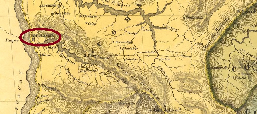
The settlement of Chapel on the Uruguay was created in February 1843 on the east bank of the Uruguay River in the Município of Alegrete, 630 km west of the provincial capital Porto Alegre. In May 1846, shortly after the end of the Farroupilha Revolution, it became a vila in its own município. Uruguaiana (as it is spelled today) has been a town since April 1874.
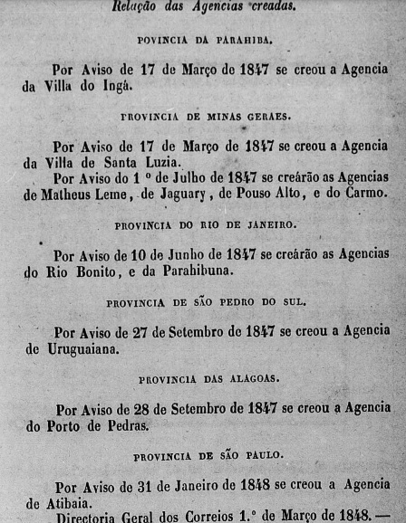
Two dates of origin for the local post office have been found. The first was in September 1847, according to the report of the Imperial Ministry:
Relatorio do Ministerio do Imperio 1847
Nova Monteiro, however, writes a date of March 1848 in Administrações e Agencias Postaes do Brasil Imperio (Brasil Filatelico/RJ, 1934-5; Reprint SPP 1994-1999). Since both dates are relatively close to each other, the second could represent the operation beginning.
In August 1887, the local station was inaugurated by the Brazil Great Southern Railway. The railway line became part of Viação Férrea Rio Grande do Sul in 1920, and from 1975 until the traffic end in 1996 it belonged to Rede Ferroviária Federal S.A. (estacoesferrroviarias.com.br). It is not yet known whether a station post office was also opened, but at least one transit cancellation exists.
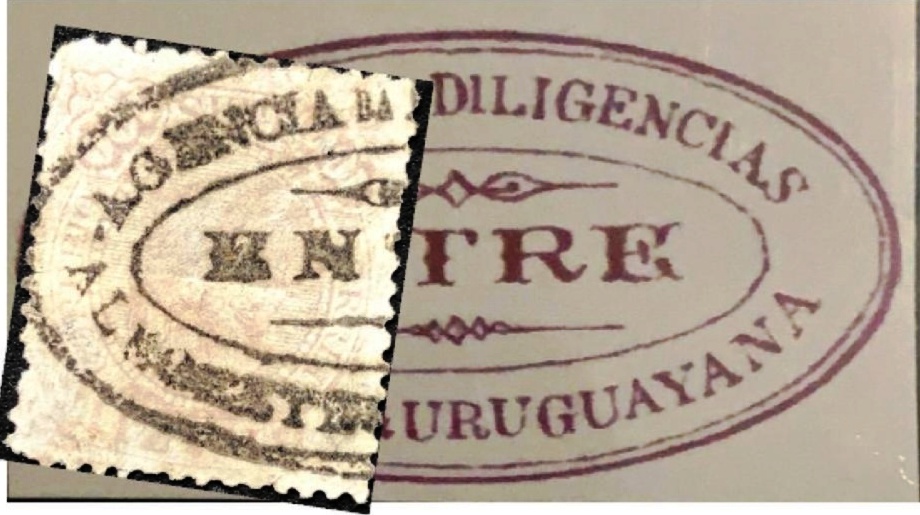
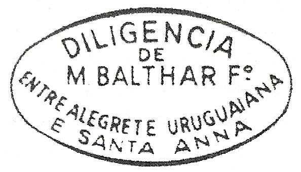
The earliest postmarks from Uruguayana so far are three diligencia cancels, i.e. from privately operated stagecoach services that travelled between Uruguayana, Alegrete and Sant’Anna (now Livramento).
They were followed by the double circle URS-0470e (Coll. Fuad Ferreira Fo.): a French type with the inscription URUGUAYANA above and the star between brackets below. It also exists in red and purple, the dates in the middle were found for the period 1877ff-1882.
At the beginning of the 1980s, two similar postmarks came into use as rectangles in purple with 3 lines each. URS-0470f (image from the internet) has the inscription CORREIO DE / URUGUAYA / NA (+ date), while URS-0470g (image from the internet) has the inscription CORREIO DE / URUGUAYANA / (date). At about the same time, URS-0470h (Coll. José A. Junges) also appeared in its rather untypical form as a vertical double oval. Here, too, the colour purple occurs frequently, the inscription at the top reads CORREIO DE URUGUAYANA, at the bottom one reads BRASIL between two stars each on the right and left. The dates in the middle are from the period 1884ff-1890.
The last postmarks in the 19th century are all double circles. URS-0470i (Coll. José A. Junges) has the inscription URUGUAYANA at the top and an ornament in X at the bottom. It also occurs in dark purple and bears dates between 1889 and 1891 inside. URS-0470j (Coll. José A. Junges) might already be Republican. Here the inscription at the top is the same as before, at the bottom one reads S.P. DO SUL. Dates in the middle go from 1891ff to 1901. Then there was also the Ambulante cancel for the railway line between Uruguayana and Quarahy. URS-0471a (Coll. FM) has already been shown as the Quarahy cancel QRS-0280b in Carimbologia Q-R. The dates in the centre so far go from 1889 to 1890.
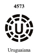
A mute and a handwritten postal cancellation are still to be shown. The former has already been described by J. Dingler and K.W. Lopes in Mute Cancellations of the Brazil Empire/ Carimbos Mudos do Brasil Império (Brazil Philatelic Association, Rio de Janeiro, 2000) under no. 4573:
BPA 4573
The handwritten cancellation ooriginates from the Karlheinz Wittig collection and was found on a D. Pedro issue from 1877:
1877ff (KW)Villiers de l’Ile Adam: Carta (…) da Provincia de São Pedro do Sul, 1847
Andere Namen: Capella do Uruguay, Sant’Anna do Uruguay
Die Kapelle am Uruguay wurde im Februar 1843 am Ostufer des Flusses Uruguay im Município von Alegrete errichtet und lag 630 km westlich der Provinzhauptstadt Porto Alegre entfernt. Im Mai 1846, also kurz nach dem Ende der Farroupilha-Revolution, erfolgte der Aufstieg zur Vila im eigenen Município. Seit April 1874 ist Uruguaiana (wie es heute geschrieben wird) eine Stadt.
Zwei Entstehungsdaten fürs örtliche Postamt wurden gefunden. Erstmals im September 1847, wie im Bericht der Imperialministeriums zu lesen ist:
Relatorio do Ministerio do Imperio 1847
Nova Monteiro schreibt aber ein Datum aus März 1848 in Administrações e Agencias Postaes do Brasil Imperio (Brasil Filatelico/RJ, 1934-5; Reprint SPP 1994-1999). Da beide Daten relativ nah zueinander liegen, könnte das zweite den Beginn des Postbetriebs darstellen.
Im August 1887 wurde der lokale Bahnhof durch die Brazil Great Southern Railway eingeweiht. Die Bahnlinie ging 1920 zur Viação Férrea Rio Grande do Sul, von 1975 bis Betriebsende 1996 gehörte sie der Rede Ferroviária Federal S.A. (estacoesferrroviarias.com.br). Es ist noch nicht bekannt, ob es auch ein Bahnhofspostamt eröffnet wurde, aber es existiert zumindest eine Transit-Entwertung.
Die bisher frühesten Poststempel aus Uruguayana sind drei Diligencia-Entwertungen, also von privat betriebenen Postkutschendiensten, die zwischen Uruguayana, Alegrete und Sant’Anna (heute Livramento) unterwegs waren.
URS-0470b (EB) 1866ff-1877ff
URS-0470c (EB) 1866ff-1877ff
URS-0470d (SB) 1883ff
Es folgte der Doppelkreis URS-0470e (Samml. Fuad Ferreira Fo.): ein französischer Typus mit der Inschrift URUGUAYANA oben und dem Stern zwischen Klammern unten. Ihn gibt es auch in rot und lila, die Daten in der Mitte wurden für den Zeitraum 1877ff-1882 gefunden.
Am Anfang der 80er Jahre kamen zwei ähnliche Poststempel als Rechteck in lila mit je 3 Zeilen im Gebrauch. URS-0470f (Abb. aus dem Internet) hat die Inschrift CORREIO DE / URUGUAYA / NA (+ Datum), während URS-0470g (Abb. aus dem Internet) die Inschrift CORREIO DE / URUGUAYANA / (Datum) trägt. Etwa zur gleichen Zeit erschien auch URS-0470h (Samml. José A. Junges) in seiner eher untypischen Form als senkrechte doppelte Oval. Auch hier kommt die Farbe lila häufig vor, die Inschrift oben lautet CORREIO DE URUGUAYANA, unten liest man BRASIL zwischen je zwei Sternen rechts und links. Die Daten in der Mitte entstammen dem Zeitraum 1884ff-1890.
Die letzten Poststempel im 19. Jahrhundert sind allesamt Doppelkreise. URS-0470i (Samml. José A. Junges) hat oben die Inschrift URUGUAYANA und unten ein Ornament in X. Er kommt auch in dunkelviolett vor und trägt Daten zwischen 1889 und 1891 im Inneren. URS-0470j (Samml. José A. Junges) dürfte bereits republikanisch sein. Hier ist die Inschrift oben gleich wie vor, unten liest man S.P. DO SUL. Daten in der Mitte 1891ff-1901. Dann gab es auch die Ambulante-Entwertung für die Bahnlinie zwischen Uruguayana und Quarahy. URS-0471a (Samml. FM) wurde bereits als der Quarahy-Stempel QRS-0280b in Carimbologia Q-R gezeigt. Die Daten in der Mitte gehen bisher von 1889 bis 1890.
Eine stumme und eine handschriftliche postalische Entwertung sind noch zu zeigen. Erstere wurde bereits durch J. Dingler und K.W. Lopes in Mute Cancellations of the Brazil Empire/ Carimbos Mudos do Brasil Império (Brazil Philatelic Association, Rio de Janeiro, 2000) unter Nr. 4573 vorgestellt:
BPA 4573
Die handschriftliche Entwertung kommt aus der Sammlung Karlheinz Wittig und wurde auf einer D. Pedro Ausgabe aus 1877 gefunden:
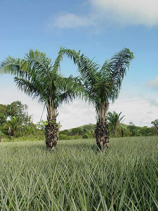
The settlement of Urucuryteua belonged to the Vila of São Miguel do Guamá since October 1870 and was located 180 km east of the provincial capital Belém do Pará. In March 1930, the place – which today is spelled Urucuriteua – became a district. And so, it has remained to this day. The Indian word urucury, or ouricuri, refers to several palm varieties of the Arecaceae family.
Attalea Phalerata/Mart. ex. Spreng (Photo: Marcelo Cavallari, CC BY-SA 4.0)
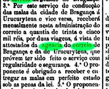
A post office in Urucuryteua is mentioned in a postal transport contract published in the official press in January 1878:
Jornal do Pará, 16.01.1878
Since this agency was not mentioned anywhere else, one can assume that it had a very short life, if it started operating at all.
Google Maps
Die Siedlung Urucuryteua gehörte seit Oktober 1870 der Vila von São Miguel do Guamá und lag 180 km östlich der Provinzhauptstadt Belém do Pará. Im März 1930 wurde der Ort – der sich heute Urucuriteua schreibt – zum Distrikt. Uns so ist es bis heute geblieben. Das indianische Wort Urucury, oder Ouricuri, bezeichnet mehrere Palmensorten der Familie Arecaceae.
Attalea Phalerata/Mart. ex. Spreng (Foto: Marcelo Cavallari, CC BY-SA 4.0)
Ein Postamt im Urucuryteua wird in einem offiziellen Postbeförderungsvertrag erwähnt, der in der Amtspresse im Januar 1878 veröffentlicht wurde:
Jornal do Pará, 16.01.1878
Da diese Agentur sonst nirgends überliefert ist, kann man annehmen, dass sie ein sehr kurzes Leben hatte, wenn sie den Betrieb überhaupt aufgenommen hat.
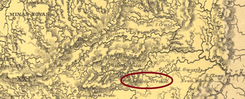
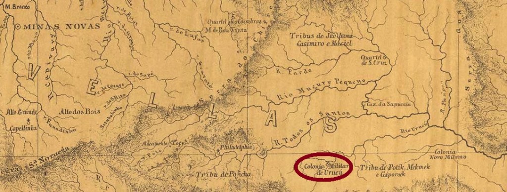
This locality was a military colony near Minas Novas from November 1877, located at the confluence of the Urucu River and the Mucuri, 600 km northeast of the provincial capital of Ouro Preto. In September 1887, the place became a district of the Município of Theophilo Ottoni. Political emancipation took place in December 1938 as the Município of Carlos Chagas. The name commemorates the doctor, epidemiologist, and biologist (1878-1934) from Minas Gerais who, among other things, discovered and described Chagas’ disease.
Paula Sobrinho writes in Historia Postal de Minas Gerais (Belo Horizonte, 1997) that there was a post office there from October 1880. The imperial postmark is UMG-3255a (Coll. José A. Junges): a double circle with the inscription URUCÚ above and (MINAS) below. The dates in the middle were found for the period 1885-1902.
Provincia de Minas Geraes, 1873
Andere Name: Carlos Chagas (1938)
Diese Ortschaft war ab November 1877 eine Militärkolonie bei Minas Novas, die an der Mündung vom Urucu-Fluss in den Mucuri lag, 600 km nordöstlich der Provinzhauptstadt Ouro Preto entfernt. Im September 1887 wurde der Ort zum Distrikt des Município von Theophilo Ottoni. Die politische Emanzipation erfolgte im Dezember 1938 als Município von Carlos Chagas. Der Name erinnert an den Arzt, Epidemiologe und Biologe (1878-1934) aus Minas Gerais, der u.a. die Chagas-Krankheit entdeckt und beschrieben hat.
Paula Sobrinho schreibt in Historia Postal de Minas Gerais (Belo Horizonte, 1997), dass es dort ab Oktober 1880 ein Postamt existierte. Der kaiserliche Poststempel ist UMG-3255a (Samml. José A. Junges): ein Doppelkreis mit der Inschrift URUCÚ oben und (MINAS) unten. Die Daten in der Mitte wurden für den Zeitraum 1885-1902 gefunden.
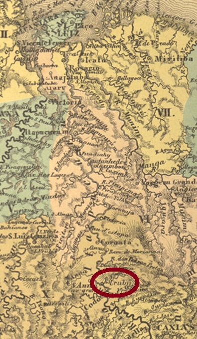
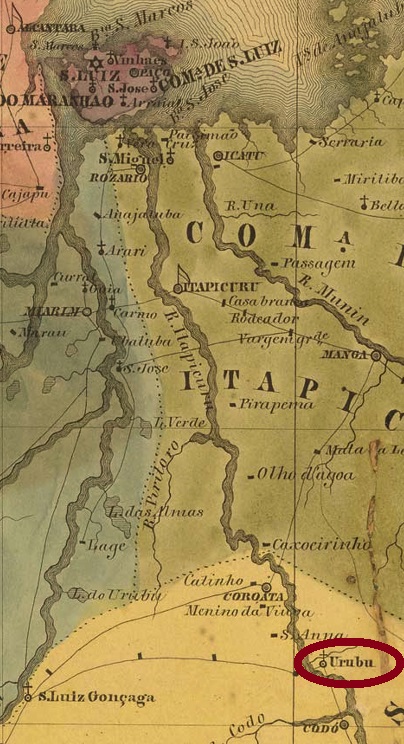
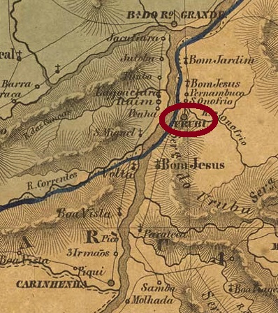
This settlement in the Codó region has been known since 1838 and was located on the east bank of the Itapicuru River, 280 km south of the provincial capital São Luís. Around 1889, the place name was changed to Monte Alegre, and since December 1943, it has been the Município of Timbiras. The term refers to a whole group of Indian tribes in the north and northeast of Brazil.
As the postal report (Relatorio Postal) for 1887 shows, there was a post office there from February 1869. An imperial postmark from this place has appeared, not the first one. UMA-0275b (Collected by Fuad Ferreira Fo.) is a double circle with the inscription URUBÚ above and one (2) below. The dates in the middle go from 1883 to 1886.
Villiers de l’Ile Adam: Carta (…) da Provincia do Maranhão, 1850
Andere Namen: Monte Alegre, Timbiras (1943)
Diese Siedlung in der Gemarkung Codó ist seit 1838 überliefert und lag am Ostufer des Flusses Itapicuru, 280 km südlich der Provinzhauptstadt São Luís. Gegen 1889 wurde der Ortsname zu Monte Alegre geändert, und seit Dezember 1943 ist der Ort der Município von Timbiras. Der Begriff bezeichnet eine ganze Gruppe von Indianerstämmen im Norden und Nordosten Brasiliens.
Wie aus dem Postbericht (Relatorio Postal) für 1887 hervorgeht, gab es dort ein Postamt ab Februar 1869. Ein kaiserlicher Poststempel aus diesem Ort ist aufgetaucht, aber nicht der erste. UMA-0275b (Samml. Fuad Ferreira Fo.) ist ein Doppelkreis mit der Inschrift URUBÚ oben und einer (2) unten. Die Daten in der Mitte gehen von 1883 bis 1886.
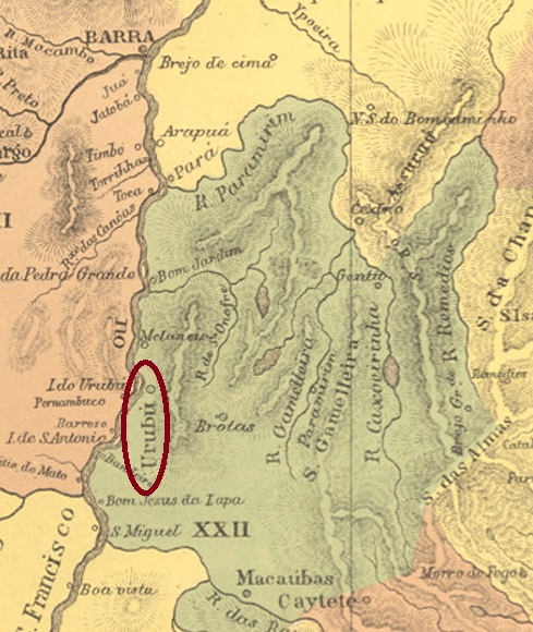
The word Urubu in Brazil refers to both an Indian tribe (also called Kaa’por) and many bird species of the vulture family Cathartidae. However, since the Indians were located further west of Bahia, we can assume that the bird was meant here:
The freguesia of Santo Antonio do Urubu de Cima (St. Anthony on the Upper Vulture) was established as early as 1718 in the Jacobina county, located on the east bank of the Rio São Francisco, 730 km west of the later provincial capital Salvador da Bahia. It was promoted to vila in March 1746, and to town in June 1897. After that, the name changed twice, probably because the local authorities were not comfortable with such denomination: in 1912 to Rio Branco and in 1943 to Paratinga (= Rio Branco/White River, in Tupi-guarani), which is still current today.
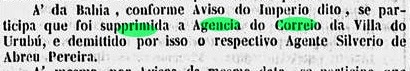
The local post office had at least two periods of operation, although the first beginning could not yet be determined. This first period of operation ended in February 1847, according to the Rio official press:
Gazeta Official/RJ, 24.02.1847
The reopening took place in November 1857, as Nova Monteiro writes in Administrações e Agencias Postaes do Brasil Imperio (Brasil Filatelico/RJ, 1934-5; Reprint SPP 1994-1999). This is confirmed by Aureo G. Santos in Agências de Correio Criadas e Suprimidas 1851, 1855, 1856 e 1857 (Brasil Filatélico 181, Rio de Janeiro, 1977):
Aureo G. Santos (op. cit.)
One 19th century postmark has been found, although here too the attribution awaits final confirmation. UBA-0755b (Coll. Klerman W. Lopes) is a double circle with the inscription URUBU above and an (I) below. The only specimen bears a date from 1890 in the centre.
Villiers de l’Ile Adam: Carta (…) da Provincia da Bahia, 1848
Andere Namen: Rio Branco, Paratinga (1943)
Das Wort Urubu bezeichnet in Brasilien sowohl einen Indianerstamm (auch Kaa’por genannt) als auch viele Vogelarten der Geierfamilie Cathartidae. Da aber die Indianer weiter westlich von Bahia beheimatet waren, können wir annehmen, dass hier der Vogel gemeint war:
Die Freguesia von Santo Antonio do Urubu de Cima (Hl. Antonius am Oberen Assgeier) entstand bereits 1718 in der Gemarkung Jacobina und lag am Ostufer des Rio São Francisco, 730 km westlich der späteren Provinzhauptstadt Salvador da Bahia entfernt. Im März 1746 erfolgte der Aufstieg zur Vila, und im Juni 1897 zur Stadt. Danach wechselte der Name zweimal, wohl weil sich die lokale Obrigkeit nicht mit einem Ort namens Assgeier anfreunden konnte: 1912 zu Rio Branco und 1943 zum heute noch aktuellen Paratinga (= Rio Branco/Weißer Fluss, in Tupi-guarani).
Das lokale Postamt hatte mindestens zwei Betriebsperioden, wobei der erstmalige Beginn noch nicht ermittelt werden konnte. Diese erste Betriebszeit endete im Februar 1847, wie die Amtspresse aus Rio mitteilt:
Gazeta Official/RJ, 24.02.1847
Die Wiedereröffnung fand im November 1857 statt, wie Nova Monteiro in Administrações e Agencias Postaes do Brasil Imperio (Brasil Filatelico/RJ, 1934-5; Reprint SPP 1994-1999) schreibt. Dies wird durch Aureo G. Santos in Agências de Correio Criadas e Suprimidas 1851, 1855, 1856 e 1857 (Brasil Filatélico 181, Rio de Janeiro, 1977) bestätigt:
Aureo G. Santos (op. cit.)
Ein Poststempel des 19. Jahrhunderts wurde gefunden, wobei auch hier die Zuordnung auf eine endgültige Bestätigung wartet. UBA-0755b (Samml. Klerman W. Lopes) ist ein Doppelkreis mit der Inschrift URUBU oben und einem (I) unten. Das einzige Exemplar trägt ein Datum aus 1890 in der Mitte.
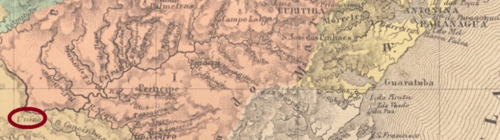
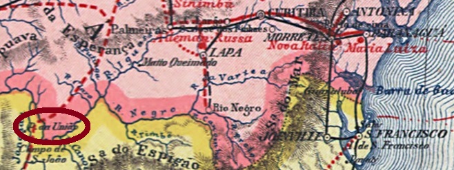
The old settlement called Porto União near Palmas became the Freguesia of Porto União de N.Sa. da Victoria in 1855 and was located on the south bank of the river Iguaçu, 230 km south of the provincial capital Curitiba. In April 1880, the place name was simplified to União da Victoria. Ten years later it was promoted to Vila, and since March 1908 União da Vitória (as it is written today) has been a town. Today, the state border with Santa Catarina lies within the city limits. This is the result of a dispute that flared up with the Contestado civil war (1912-1916). A separation throughout the locality called União (Concord)…
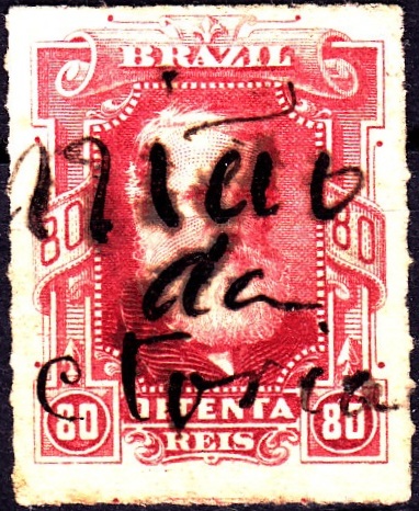
As can be seen from the Directory of Imperial Post Offices (Tabella das Agencias do Correio do Imperio, Rio de Janeiro, 1885), there was a post office there since 1880. Probably the postmark was not finished in time, as a handwritten cancellation is known from that period:
1880ff (Coll. Karlheinz Wittig)
The first postmark is probably UPR-0235a (Coll. José A. Junges): a double circle with the above inscription UNIÃO DA VICTORIA, and dates inside from about 1884 to 1892.
Carta da Republica dos Estados Unidos do Brasil, 1892
Anderer Name: Porto União
Die alte Siedlung namens Porto União bei Palmas wurde 1855 zur Freguesia von Porto União de N. Sa. da Victoria und lag am Südufer des Flusses Iguaçu, 230 km südlich der Provinzhauptstadt Curitiba entfernt. Im April 1880 wurde der Ortsname zu União da Victoria vereinfacht. Zehn Jahre später erfolgte der Aufstieg zur Vila, seit März 1908 ist União da Vitória (wie heute geschrieben wird) eine Stadt. Heute liegt die Landesgrenze zu Santa Catarina im Stadtgebiet. Das ist das Ergebnis eines Grenzstreits, der mit dem Contestado-Bürgerkrieg (1912-1916) entflammte. Eine Trennung durch die Stadt, die União (Eintracht) heißt…
Wie aus dem Verzeichnis der kaiserlichen Postämter (Tabella das Agencias do Correio do Imperio, Rio de Janeiro, 1885) hervorgeht, gab es dort ein Postamt seit 1880. Wahrscheinlich wurde der Poststempel nicht rechtzeitig fertig, da aus dieser Zeit eine handschriftliche Entwertung bekannt ist:
1880ff (Samml. Karlheinz Wittig)
Der erste Ortsstempel ist wohl UPR-0235a (Samml. José A. Junges): ein Doppelkreis mit der obigen Inschrift UNIÃO DA VICTORIA, mit Daten im Inneren von ca. 1884 bis 1892.
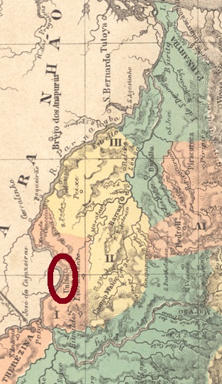
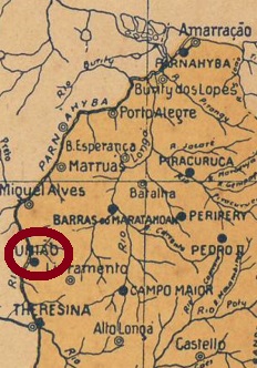
The Freguesia of N. Sa. dos Remedios da União came into being in August 1853 and was located on the east bank of the river Parnaiba, 90 km north of the then newly crowned provincial capital Teresina. Only a month later, it was promoted to a vila, and since December 1889, União has been a town.
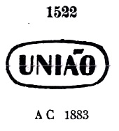
Two years of origin for the local post office were found. First in March 1856, as Nova Monteiro writes in Administrações e Agencias Postaes do Brasil Imperio (Brasil Filatelico/RJ, 1934-5; Reprint SPP 1994-1999). Then 1880, as listed in the Directory of Imperial Post Offices (Tabella das Agencias do Correio do Imperio, Rio de Janeiro, 1885). There are also two 19th century local postmarks, the first of which has not yet been definitively confirmed.
UPI-0170a was already presented by Paulo Ayres in the Catálogo de Carimbos Brasil-Império (S. Paulo, 1937, 1942) under No. 1522, and Cicero A. Almeida assigned it to the province of Piauí in his Carimbos Postais – século XIX (Rio de Janeiro, 1989) under no. MPT 353:
UPI-0170a (P.A. 1522, MPT 353) 1883ff
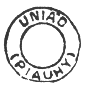
Also from Almeida’s work there comes UPI 0170b, which is then clearly from Piauí:
UPI-0170b (MPT 780)Arthur D. Ribeiro: Estado do Piauhy, 1924
Die Freguesia von N. Sa. dos Remedios da União entstand im August 1853 und lag am Ostufer des Flusse Parnaiba, 90 km nördlich der damals frisch gekürten Provinzhauptstadt Teresina entfernt. Bereits ein Monat später erfolgte der Aufstieg zur Vila, und seit Dezember 1889 ist União eine Stadt.
Zwei Entstehungsjahre fürs örtliche Postamt wurden gefunden. Erstmals im März 1856, wie Nova Monteiro in Administrações e Agencias Postaes do Brasil Imperio (Brasil Filatelico/RJ, 1934-5; Reprint SPP 1994-1999) schreibt. Dann 1880, wie im Verzeichnis der kaiserlichen Postämter (Tabella das Agencias do Correio do Imperio, Rio de Janeiro, 1885) aufgelistet. Ebenfalls zwei Ortsstempel für den 19. Jahrhundert liegen vor, wobei der erste davon noch nicht endgültig bestätigt ist.
UPI-0170a wurde bereits durch Paulo Ayres im Catálogo de Carimbos Brasil-Império (S. Paulo, 1937, 1942) unter der Nr. 1522 vorgestellt, und Cicero A. Almeida hat ihn der Provinz Piauí in seinem Carimbos Postais – século XIX (Rio de Janeiro, 1989) unter Nr. MPT 353 zugeordnet:
UPI-0170a (P.A. 1522, MPT 353) 1883ff
Auch aus Almeidas Werk kommt UPI 0170b, der dann eindeutig aus Piauí zu erkennen ist:
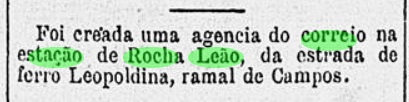
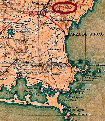
The Rocha Leão train station in the Coastal Line of the Estrada de Ferro Leopoldina was inaugurated in November 1888 near Rio das Ostras (RRJ-0845). Some sources state the original station name was União, but this could not be confirmed. The railway belonged to the E.F. Leopoldina until 1975. From then on until 1996 it was run by the Rede Ferroviária Federal S.A. Now the station house serves as a museum and cultural centre (see image below), and Rocha Leão is a district of Rio das Ostras.
According to Paulo Novaes (agenciaspostais.com.br), the station post office was created in November 1888, which can be confirmed by the regional press:
Gazeta de Noticias, November 17, 1888
A single early cancel is known: RRJ-2154a (image from the internet) has a double circle with the inscription ROCHA LEÃO above and a cross-like ornament below. Dates inside found for 1897-1899.
Almanak Laemmert, 1892
Siehe auch Rocha Leão (RRJ-2154)
Der Bahnhof Rocha Leão wurde im November 1888 durch die Estrada de Ferro Leopoldina in der so genannten Küstenlinie eingeweiht und lag etwas nördlich von Rio das Ostras (RRJ-0845). Einige Quellen behaupten, União war der ursprüngliche Name des Bahnhofs, aber dies konnte nicht bestätigt werden. Die Eisenbahnlinie gehörte bis 1975 der E. F. Leopoldina. Von nun an bis Betriebsende in 1996 war sie Eigentum der Rede Ferroviária Federal S. A. Heute dient das Bahnhofshaus als Museum und Kulturzentrum, und Rocha Leão ist ein Distrikt im Município von Rio Das Ostras.
Laut Paulo Novaes (agenciaspostais.com.br) wurde das Postamt im November 1888 in die Wege geleitet, was auch in der Presse zu lesen ist:
Gazeta de Noticias, 17.11.1888
Ein einziger Stempel der Frühzeit ist überliefert: RRJ-2154a (Abb. aus dem Internet) hat einen Doppelkreis mit der Inschrift ROCHA LEÃO oben und ein kreuzförmiges Ornament unten. Im Gebrauch zwischen 1897 und 1899.
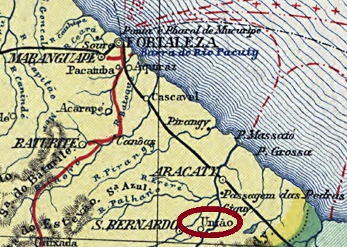
The freguesia of Sant’Anna da União was created in December 1863 and was located in the Município of Aracati, on the west bank of the river Jaguaribe, 180 km southeast of the provincial capital Fortaleza. Exactly two years later the place rose to the status of a vila, it became a town in September 1890 and has been called Jaguaruana since December 1943. The name originates from the Indian language and means Black Jaguar.
The local post office was established in February 1871, according to the regional press:
Cearense, 16.02.1871
So far, no imperial postmark could be assigned with certainty to this locality.
Carta da Republica dos Estados Unidos do Brazil, 1892
Andere Namen: Caatinga do Góis, Jaguaruana (1943)
Die Freguesia von Sant’Anna da União entstand im Dezember 1863 und lag im Município von Aracati am Westufer des Flusses Jaguaribe, 180 km südöstlich der Provinzhauptstadt Fortaleza entfernt. Genau zwei Jahre später stieg der Ort zur Vila auf und wurde im September 1890 eine Stadt, die seit Dezember 1943 Jaguaruana heißt. Der Name aus der Indianersprache bedeutet Schwarzer Jaguar.
Das örtliche Postamt wurde im Februar 1871 ins Leben gerufen, wie die Regionalpresse mitteilte:
Cearense, 16.02.1871
Bisher konnte kein kaiserlicher Poststempel mit Sicherheit dieser Ortschaft zugeordnet werden.