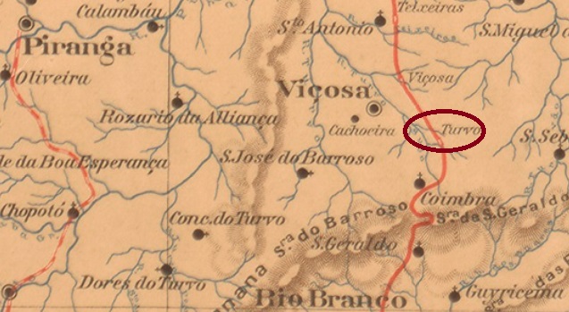
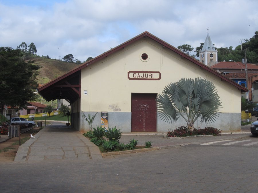
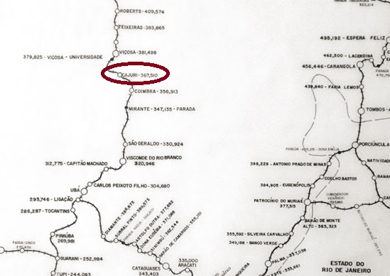
Turvo station was inaugurated in October 1885 by the E.F. Leopoldina (Caratinga Line) in the Município of Viçosa (formerly Santa Rita do Turvo) and was located on the east bank of the Turvo, 140 km southeast of the provincial capital of Ouro Preto. The railway line became part of the Rede Ferroviária Federal in 1975 until it was closed in 1996. The station building is very well preserved today, and the entire station square is listed as a cultural asset. This is a remarkable exception among Brazilian municipalities (estacoesferroviarias.com.br).
June 2021 (Photo: Julio Alves, in estacoes ferroviarias.com.br)
Around the station, the settlement continued to grow and became a district called Cajury in December 1938. Since December 1962, Cajuri (as it is now spelled) has been an independent municipality.
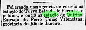
The station post office was created in April 1886, as reported by the Rio press:
O Paiz/RJ 04.04.1886
The station postmark of the imperial period is TMG-3587a (Coll. José A. Junges): a double circle with the inscriptions ESTM DO TURVO above and (MINAS) below, which also exists in blue. Dates in the centre go from 1886 to 1890.
Estrada de Ferro Leopoldina
Anderer Name: Est. Cajury (1910)
Der Bahnhof Turvo wurde im Oktober 1885 durch die E.F. Leopoldina (Caratinga-Linie) im Município von Viçosa (ehemals Santa Rita do Turvo) eingeweiht und lag am Ostufer des Turvo, 140 km südöstlich der Provinzhauptstadt Ouro Preto entfernt. Die Bahnlinie ging 1975 zur Rede Ferroviária Federal bis zur Stilllegung 1996. Das Bahnhofsgebäude ist heute sehr gut erhalten, der gesamte Bahnhofsplatz steht als Kulturgut unter Denkmalschutz. Eine vorbildliche Ausnahme unter den Gemeinden Brasiliens (estacoesferroviarias.com.br).
Im Juni 2021 (Foto: Julio Alves, in estacoes ferroviarias.com.br)
Um den Bahnhof wuchs die Siedlung weiter und wurde im Dezember 1938 zu einem Distrikt namens Cajury. Seit Dezember 1962 ist Cajuri (wie es nun geschrieben wird) eine eigenständige Gemeinde.
Das Bahnhofspostamt existierte ab April 1886, wie die Presse aus Rio berichtete:
O Paiz/RJ 04.04.1886
Der Bahnhofspoststempel der Kaiserzeit ist TMG-3587a (Samml. José A. Junges): ein Doppelkreis mit den Inschriften ESTM DO TURVO oben und (MINAS) unten, den es auch in blau gibt. Daten in der Mitte von 1886 bis 1890.
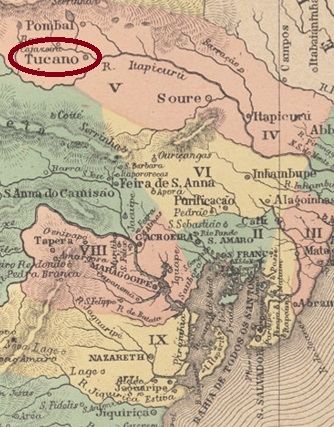
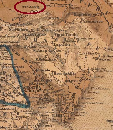
Tucano (Toucan) was the name of a freguesia of the villa of Itapicuru, 270 km north of the provincial capital Salvador da Bahia, from 1754. In March 1837, it became a villa in its own município. In the 20th century, there was a short period (1931-1933) as a district of the municipality of Cipó (Liane), before its status as a município was restored.
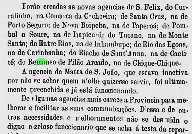
Two founding years for the local post office have been identified. Either the agency was closed in the meantime, or it did not start operating at all after it was first established. The year 1872 appears both in the Directory of Imperial Post Offices (Tabella das Agencias do Correio do Imperio, Rio de Janeiro, 1885) and in the Provincial President’s Report for May of that year:
Relatorio do Presidente da Provincia/BA, 03/1872
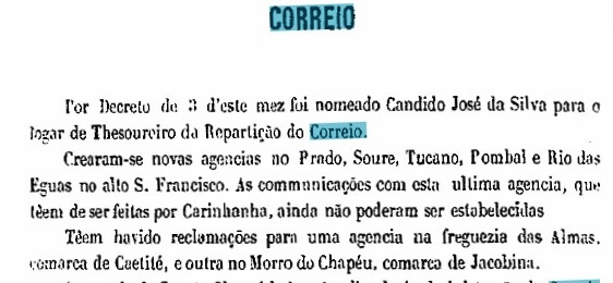
A second opening around 1875 was mentioned in the Provincial Report for 1876:
Relatorio do Presidente da Provincia/BA, 1876
So far, no imperial postmark could be found for this locality.
Villiers de l’Ile Adam: Carta (…) da Provincia da Bahia, 1848
Tucano (Tukan) hieß ab 1754 eine Freguesia der Villa von Itapicuru, die 270 km nördlich der Provinzhauptstadt Salvador da Bahia entfernt lag. Im März 1837 wurde daraus eine Villa im eigenen Município. Im 20. Jahrhunderte erfolgte eine kurze Periode (1931-1933) als Distrikt von der Gemeinde Cipó (Liane), bevor der Status als Município wiederhergestellt wurde.
Zwei Gründungsjahre fürs örtliche Postamt wurden ermittelt. Entweder wurde die Agentur zwischendurch geschlossen, oder nach der ersten Entstehung gar nicht in Betrieb genommen. Das Jahr 1872 liest man sowohl im Verzeichnis der kaiserlichen Postämter (Tabella das Agencias do Correio do Imperio, Rio de Janeiro, 1885) als auch im Bericht des Provinzpräsidenten für den Mai d. Js.:
Relatorio do Presidente da Provincia/BA, 03/1872
Über eine zweite Eröffnung um 1875 wurde die Rede im Provinzbericht für 1876:
Relatorio do Presidente da Provincia/BA, 1876
Bisher konnte kein kaiserlicher Poststempel für diese Ortschaft gefunden werden.
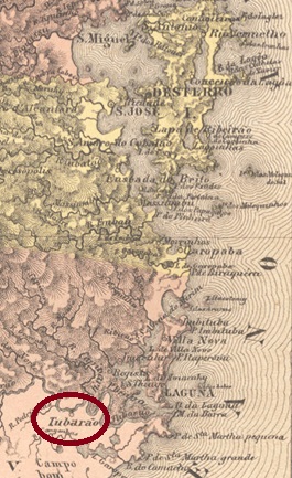
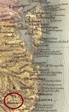
The parish of Nossa Senhora da Piedade de Tubarão (Our Lady of the Piety of the Shark) was established in 1836 in the Município of Laguna and was located on the Tubarão River, 140 km south of the provincial capital of Desterro (now Florianópolis). In May 1870, the place became a villa in its own município.
The local post office was established in 1874, as can be seen in the Directory of Imperial Post Offices (Tabella das Agencias do Correio do Imperio, Rio de Janeiro, 1885). The imperial postmark is TSC-0265a (Coll. José A. Junges) a plain double circle with the inscription TUBARAO on top, which also exists in blue. The dates in the middle are from the period 1877-1889.
Villiers de l’Ile Adam: Carta (…) da Provincia de Santa Catharina, 1847
Die Pfarrei von Nossa Senhora da Piedade de Tubarão (Unsere Liebe Frau der Pietät des Haifisches) entstand 1836 im Município von Laguna und lag am Fluss Tubarão, 140 km südlich der Provinzhauptstadt Desterro (heute Florianópolis) entfernt. Im Mai 1870 stieg der Ort zur Villa im eigenen Município auf.
Das örtliche Postamt entstand 1874, wie man im Verzeichnis der kaiserlichen Postämter (Tabella das Agencias do Correio do Imperio, Rio de Janeiro, 1885) lesen kann. Der kaiserliche Poststempel ist TSC-0265a (Samml. José A. Junges) ein schlichter Doppelkreis mit der Inschrift TUBARAO oben, den es auch in blau gibt. Die Daten in der Mitte entstammen dem Zeitraum 1877-1889.
Carta da Republica dos Estados Unidos do Brazil, 1892
See also Palmares/PE in R. Koester: Carimbologia XXIX
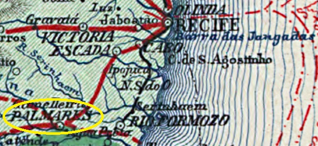
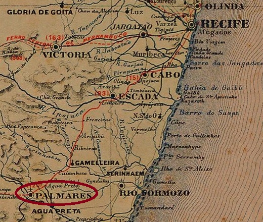
Trombetas (“trumpets”) was the name of an Indian tribe that was still in this region around 1800, 120 km southwest of Recife. An Engenho (large sugar cane plantation) was named after these Indians, which was established a few decades later close to the settlement of Montes. Around this engenho, another settlement grew amazingly fast, due to the construction of the Una railway station in 1862 by the E.F. Recife ao São Francisco railway company and also due to blacks who had arrived, probably from the Palmares quilombo region in neighbouring Alagoas.
In May 1868, the village became a district called Palmares, which was then in the município of Água Preta. Five years later, the ascent to Villa was celebrated, and it only took another 6 years for Palmares to become a city. By the end of 1890, the town is said to have had over 25 thousand inhabitants.
The local post office came into being in September 1866, as Nova Monteiro writes in Administrações e Agencias Postaes do Brasil Imperio (in Brasil Filatelico/RJ, 1934-5; reprint SPP 1994-1999). The year is confirmed by the Directory of Imperial Post Offices (Tabella das Agencias do Correio do Imperio, Rio de Janeiro, 1885) under Palmares. However, in 1866 the town – and probably also this agency – was still called Trombetas. This name can be read in the regional press until at least 1869. The Una station – which had an own post office since 1864 – was renamed Palmares between 1875 and 1879, also because another Una locality had been created near Rio Formoso (UPE-0730, post office since 1877).
No Trombetas postmark has been found so far. For town postmarks with PALMARES see Koester, Carimbologia XXIX.
Carta Corographica da Provincia de Pernambuco, 1880
Siehe auch Palmares/PE in R. Koester: Carimbologia XXIX
Trombetas („Trompeten“) hieß tatsächlich ein Indianerstamm, der um 1800 noch in dieser Region weilte, 120 km südwestlich von Recife. Nach diesen Indianern wurde auch der Engenho (Zuckerrohr-Großplantage) benannt, der wenige Jahrzehnte später dort nah an der Siedlung Montes entstand. Um diesen Engenho wuchs dann eine weitere Siedlung erstaunlich schnell, bedingt durch den Bau des Bahnhofs Una 1862 durch die E.F. Recife ao São Francisco Bahngesellschaft und auch durch angereiste Schwarze, die wohl aus der Palmares-Quilomboregion im benachbarten Alagoas kamen.
Im Mai 1868 wurde aus dem Dorf ein Distrikt namens Palmares, der nun im Município von Água Preta lag. Fünf Jahre später wurde der Aufstieg zu Villa gefeiert, und weitere 6 Jahre hat es nur gebraucht, bis Palmares eine Stadt wurde. Ende 1890 soll die Stadt bereits über 25 Tausend Einwohner gezählt haben.
Das örtliche Postamt entstand im September 1866, wie Nova Monteiro in Administrações e Agencias Postaes do Brasil Imperio (in Brasil Filatelico/RJ, 1934-5; Reprint SPP 1994-1999) schreibt. Das Jahr wird durch das Verzeichnis der kaiserlichen Postämter (Tabella das Agencias do Correio do Imperio, Rio de Janeiro, 1885) unter Palmares bestätigt. Allerdings hieß 1866 der Ort – und wohl auch diese Agentur – noch Trombetas. Diesen Namen liest man in der Regionalpresse bis mindestens 1869. Der Bahnhof Una hatte ein eigenes Postamt ab 1864 und wurde zwischen 1875 und 1879 zu Palmares umbenannt, auch weil eine weitere Ortschaft Una bei Rio Formoso entstanden war (UPE-0730, Postamt seit 1877). Bisher wurde kein Trombetas-Poststempel gefunden. Für Ortsstempel mit PALMARES siehe Koester, Carimbologia XXIX.
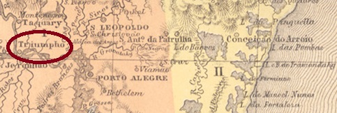
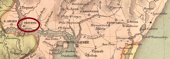
The southernmost Triumpho in imperial Brazil was already a freguesia from October 1754, located barely 80 km west of the later provincial capital Porto Alegre. In October 1831, it became a villa in its own município.
Two foundation dates for the local post office were found. First in October 1831, as Nova Monteiro writes in Administrações e Agencias Postaes do Brasil Imperio (in Brasil Filatelico/RJ, 1934-5; reprint SPP 1994-1999). Then in 1846, immediately after the Farroupilha uprising had ended, as can be read in the 1846 Annual Report:
Annuario Politico Historico e Estatistico do Brazil, 1846
Two postmarks in the double circle from the Empire have been registered, unfortunately not the oldest. TRS-0465b (Coll. José A. Junges) has the inscription TRIUMPHO at the top and an (I) at the bottom. The dates in the middle are from the period 1877-1888. Its successor TRS-0465c (Coll. José A. Junges) has the same inscription at the top, but at the bottom there is now an ornament in lozenge, formed by four small lozenges. Inner dates go from 1880 to 1889.
Villiers de l’Ile Adam: Carta (…) da Provincia de São Pedro do Sul, 1847
Der südlichste Triumpho im kaiserlichen Brasilien war bereits ab Oktober 1754 eine Freguesia, die knapp 80 km westlich der späteren Provinzhauptstadt Porto Alegre lag. Im Oktober 1831 erfolgte dann der Aufstieg zur Villa im eigenen Município.
Zwei Gründungsdaten fürs örtliche Postamt wurden gefunden. Erstmals im Oktober 1831, wie Nova Monteiro im Administrações e Agencias Postaes do Brasil Imperio (in Brasil Filatelico/RJ, 1934-5; Reprint SPP 1994-1999) schreibt. Dann 1846, unmittelbar nach Beendigung des Farroupilha-Aufstands, wie im Jahresbericht 1846 zu lesen ist:
Annuario Politico Historico e Estatistico do Brazil, 1846
Zwei Poststempel im Doppelkreis aus dem Kaiserreich sind erfasst worden, leider nicht der älteste. TRS-0465b (Samml. José A. Junges) hat oben die Inschrift TRIUMPHO und unten steht eine (I). Die Daten in der Mitte entstammen dem Zeitraum 1877-1888. Sein Nachfolger TRS-0465c (Samml. José A. Junges) hat oben die gleiche Inschrift, unten ist nun ein Ornament in Raute zu sehen, das aus vier kleinen Rauten gebildet wird. Innere Daten von 1880 bis 1889.
Carta da Republica dos Estados Unidos do Brazil, 1892
Other names: Campo Grande, Augusto Severo
See also Campo Grande/RN (R. Koester: Carimbologia VIII)
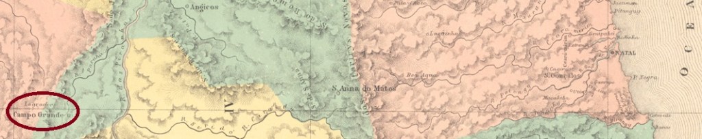
This locality was the district of Sant’Anna do Campo Grande in the Município of Caraúbas, 280 km west of the provincial capital of Natal, from October 1837. In September 1858, the place rose to a villa called Campo Grande, but in March 1868 it was downgraded again as a district of Caraúbas. Two years later, in May 1870, it rose again to Villa, which was renamed Augusto Severo in August 1903. The name celebrated Augusto Severo de Albuquerque Magalhães (1864-1902), a politician, journalist inventor and airship builder born in Rio Grande do Norte. Nevertheless, in June 2019, the Município regained its old name of Campo Grande.
Three foundations for the local post office were found. First in September 1836, still under the place name Campo Grande, as stated by both Reinhold Koester (Carimbologia VIII) and the Directory of Imperial Post Offices (Tabella das Agencias do Correio do Imperio, Rio de Janeiro, 1885). Then again in February 1843, as Nova Monteiro writes in Administrações e Agencias Postaes do Brasil Imperio (in Brasil Filatelico/RJ, 1934-5; reprint SPP 1994-1999). And most recently around 1871, now under the toponym Triumpho, as shown in the Provincial President’s Report for 1872:
Relatorio do Presidente da Provincia/RN, October 1872
So far, no imperial postmark could be assigned to this locality with certainty. For postal marks with Campo Grande, see Koester: Carimbologia VIII)
Atlas do Imperio do Brasil, 1868
Andere Namen: Campo Grande, Augusto Severo
Siehe auch Campo Grande/RN (R. Koester: Carimbologia VIII)
Diese Ortschaft war ab Oktober 1837 der Distrikt von Sant’Anna do Campo Grande im Município von Caraúbas, der 280 km westlich der Provinzhauptstadt Natal entfernt lag. Im September 1858 stieg der Ort zu einer Villa namens Campo Grande, wurde aber im März 1868 wieder als Distrikt von Caraúbas herabgesetzt. Zwei Jahre später, im Mai 1870 erfolgte erneut der Aufstieg zu Villa, die im August 1903 zu Augusto Severo umbenannt wurde. Der Name erinnerte an Augusto Severo de Albuquerque Magalhães (1864-1902), einem Politiker, Journalist Erfinder und Luftschiffbauer, der in Rio Grande do Norte geboren wurde. Dennoch, im Juni 2019 erhielt der Município den alten Namen Campo Grande zurück.
Drei Gründungen fürs örtliche Postamt wurden gefunden. Erstmals im September 1836, noch unter dem Ortsnamen Campo Grande, wie sowohl Reinhold Koester (Carimbologia VIII) als auch das Verzeichnis der kaiserlichen Postämter (/Tabella das Agencias do Correio do Imperio, Rio de Janeiro, 1885) übereinstimmend berichten. Dann wieder im Februar 1843, wie Nova Monteiro in Administrações e Agencias Postaes do Brasil Imperio (in Brasil Filatelico/RJ, 1934-5; Reprint SPP 1994-1999) schreibt. Und zuletzt um ca. 1871, nun unter dem Ortsnamen Triumpho, wie aus dem Bericht des Provinzpräsidenten für 1872 hervorgeht:
Relatorio do Presidente da Provincia/RN, Oktober 1872
Bisher konnte kein kaiserlicher Poststempel dieser Ortschaft mit Sicherheit zugeordnet werden. Für Ortsstempel mit Campo Grande siehe Koester, Carimbologia VIII.
Carta Corographica da Provincia de Pernambuco, 1880
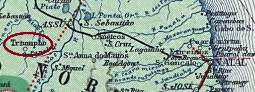
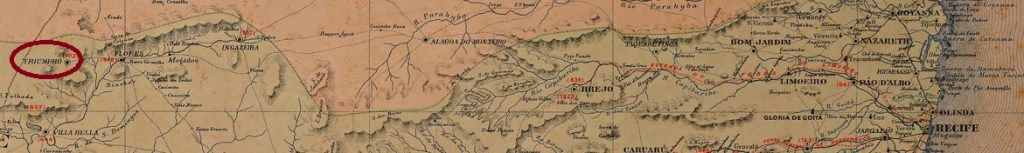
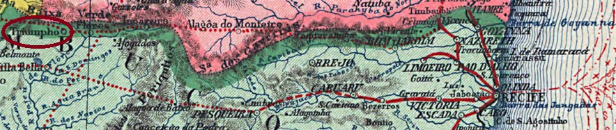
Another name: Serra da Baixa Verde
This locality was a freguesia in the Município of Flores de Ribeira do Pajeú since May 1858, located on the provincial border with Paraíba, 400 km west of the capital Recife. In June 1870, the place rose to the status of Vila in its own Município and has been a town since June 1884.
As listed in the Directory of Imperial Post Offices (Tabella das Agencias do Correio do Imperio, Rio de Janeiro, 1885), there was a post office there since 1871. The town postmark is the French type TPE-0655a (image from the Internet): a small double circle with the inscription TRIUMPHO above and the typical star between brackets below. The inner part remained empty so that the date could be entered by hand (which happened rather rarely). Found in the period ca. 1884-ca. 1888.
Carta da Republica dos Estados Unidos do Brazil, 1892
Anderer Name: Serra da Baixa Verde
Diese Ortschaft war seit Mai 1858 eine Freguesia im Município von Flores de Ribeira do Pajeú, die an der Provinzgrenze zu Paraíba lag, 400 km westlich der Hauptstadt Recife entfernt. Im Juni 1870 stieg der Ort zur Vila im eigenen Município auf, und ist eine Stadt seit Juni 1884.
Wie im Verzeichnis der kaiserlichen Postämter (Tabella das Agencias do Correio do Imperio, Rio de Janeiro, 1885) zu lesen ist, gab es dort ein Postamt seit 1871. Der Ortsstempel ist der französische Typus TPE-0655a (Abbindung aus dem Internet): ein kleiner Doppelkreis mit der Inschrift TRIUMPHO oben und dem typischen Stern zwischen Klammern unten. Der Innenteil blieb leer, damit das Datum per Hand eingetragen werden konnte (was eher selten geschah). Gefunden im Zeitraum ca. 1884-ca. 1888.
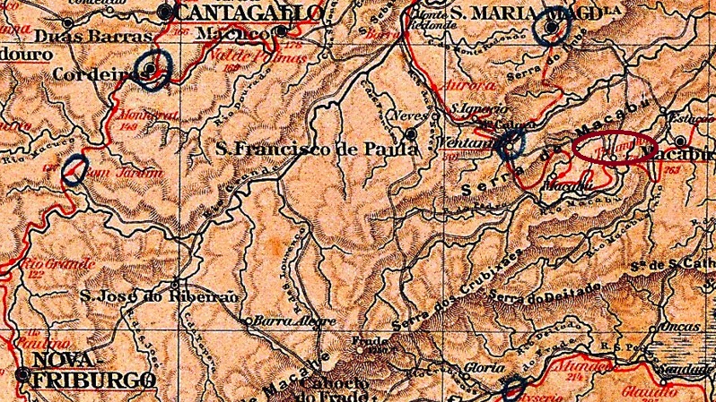
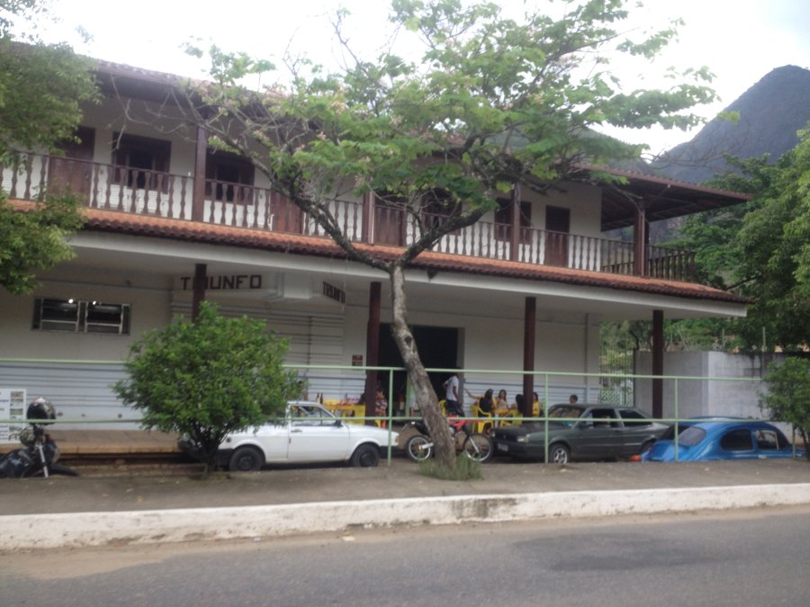
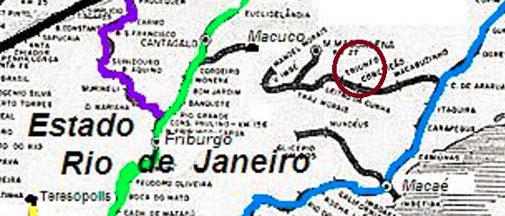
Triumpho railway station was inaugurated in March 1879 by the E.F. Barão de Araruama railway company in the municipality of Santa Maria Magdalena, about 230 km northeast of the capital Rio de Janeiro. The railway line passed to the E.F. Leopoldina in 1891 until the end of operations in 1966. Now the station building serves as a restaurant (estacoesferroviarias.com.br).
The settlement around the station continued to grow and became a district in May 1892, renamed Itapuá in December 1943 along with the station. Then in February 1950, the old name returned, now spelled Triunfo.
As Paulo Novaes writes in agenciaspostais.com.br, there was a post office there from August 1881. Only one postmark has been found for the 19th century. TRJ-1620a (image from the internet) is a double circle with the inscriptions TRIUMPHO above and (EST.) below. The only specimen bears a date from 1890 inside.
Estrada de Ferro Leopoldina
Anderer Name: Est. Itapuá (1943-1950)
Der Bahnhof Triumpho wurde im März 1879 durch die E.F. Barão de Araruama Bahngesellschaft in der Gemeinde Santa Maria Magdalena eingeweiht, ca. 230 km nordöstlich der Hauptstadt Rio de Janeiro entfernt. Die Bahnlinie ging 1891 bis zum Betriebsende 1966 zur E.F. Leopoldina über. Nun dient das Bahnhofsgebäude als Restaurant (estacoesferroviarias.com.br).
Die Siedlung um den Bahnhof wuchs weiter und wurde im Mai 1892 zum Distrikt, der im Dezember 1943 zusammen mit dem Bahnhof zu Itapuá umbenannt wurde. Im Februar 1950 kehrte dann der alte Name zurück, nun Triunfo geschrieben.
Wie Paulo Novaes in agenciaspostais.com.br schreibt, gab es dort ein Postamt ab August 1881. Nur ein Poststempel wurde für den 19. Jahrhundert gefunden. TRJ-1620a (Abb. aus dem Internet) ist ein Doppelkreis mit den Inschriften TRIUMPHO oben und (EST.) unten. Das einzige Exemplar trägt ein Datum aus 1890 im Inneren.
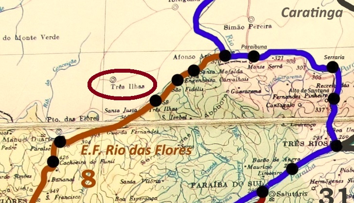
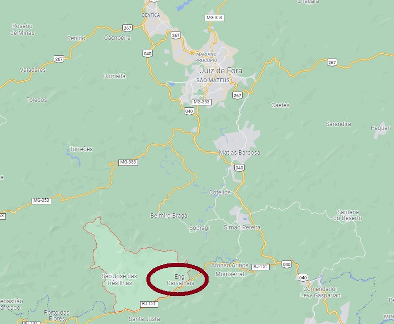
This postal agency is sometimes called Ponte (bridge), sometimes Ponto (place) in the press of the time. Here we have opted for the first name, because every bridge is also a place, but not vice versa. Besides, there was (and still is) a bridge on the Rio Preto at the provincial border between Minas Gerais and Rio de Janeiro, called Três Ilhas (Three Islands). Actually, the three islands are not located directly at the bridge, but a little further downstream, about 270 km south of the provincial capital Ouro Preto.
The place belonged to the freguesia of Vargem Grande near Juiz de Fora and had a tax post (Recebedoria), which was probably built close to the bridge. Today, the district is called Três Ilhas and is located in the Município of Belmiro Braga.
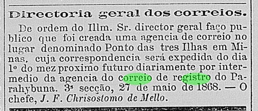
A post office was built there in 1868. Paula Sobrinho (História Postal de Minas Gerais, Belo Horizonte, 1997) writes March for it, but the postal service did not start until June of that year, as the Rio press reports:
Correio Mercantil/RJ. 28.05.1868
Apparently the local postmark was not ready in time for the opening of the agency, as revealed by a handwritten cancellation (Coll. José A. Junges) from 1870:
1870 (JJ)
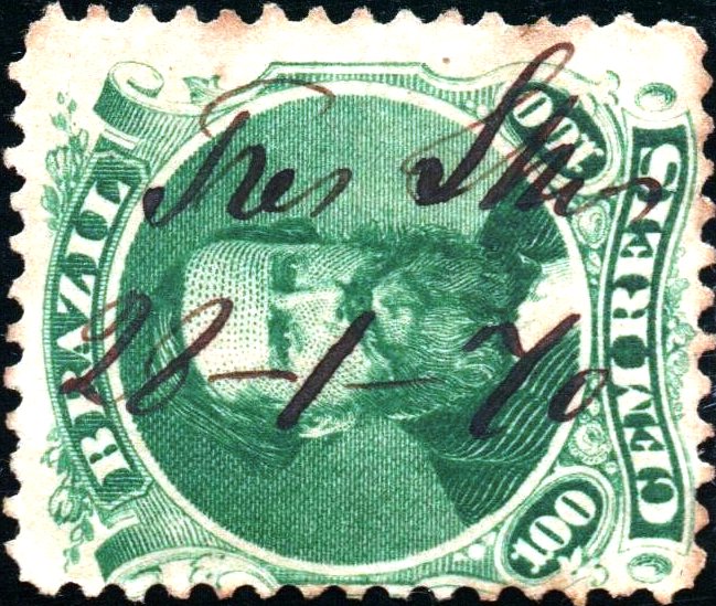
The postmark was nevertheless eventually delivered: TMG-3510a (Coll. José A. Junges) is a double circle with the inscription TREZ ILHAS at the top and dates in the middle between 1878 and 1879.
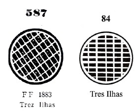
A mute cancellation is also known from there, which was in use from about 1876 to 1878 and was already presented by Paulo Ayres in the Catálogo de Carimbos Brasil-Império (S. Paulo, 1937, 1942) under no. 587. This cancellation bears no. 84 in J. Dingler and K. W. Lopes in Mute Cancellations of the Brazil Empire / Carimbos Mudos do Brasil Império (Brazil Philatelic Association, Rio de Janeiro, 2000):
P.A. 587 (BPA 84) 1876ff-1878
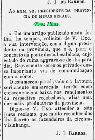
The bridge was in a very bad condition at the end of the 1870s, as reported in the regional press:
A Actualidade, 07.03.1879
Since the repair was delayed, it can be assumed that trade through the bridge came to a standstill – as was prophesied in the press report – and the post office was also soon closed. For it was no longer listed in the Directory of Imperial Post Offices (Tabella das Agencias do Correio do Imperio, Rio de Janeiro, 1885). On the other side of the river – that is, in the province of Rio de Janeiro – a post office also called Tres Ilhas opened in 1881 (TRJ-2268). And then there is also the town of São José das Três Ilhas in the area, formerly São José do Rio Preto (SMG-2480).
Google Maps
Anderer Name: Ponte das Três Ilhas
Siehe auch São José do Rio Preto (SMG-2480)
Diese Postagentur wird in der damaligen Presse mal als Ponte (Brücke), mal als Ponto (Stelle) genannt. Hier haben wir uns für die erste Bezeichnung entschieden, denn jede Brücke ist auch eine Stelle, aber umgekehrt nicht. Außerdem gab es (und gibt es noch) an der Provinzgrenze zwischen Minas Gerais und Rio de Janeiro tatsächlich eine Brücke am Rio Preto, die Três Ilhas (Drei Insel) heißt. Nun liegen die drei Insel nicht direkt an der Brücke, sondern etwas weiter flussabwärts, ca. 270 km südlich der Provinzhauptstadt Ouro Preto entfernt.
Der Ort gehörte der Freguesia von Vargem Grande bei Juiz de Fora und hatte eine Steuerstelle (Recebedoria), die wohl nah an der Brücke errichtet wurde. Heute heiß der Distrikt Três Ilhas und liegt im Município von Belmiro Braga.
Dort entstand 1868 ein Postamt. Paula Sobrinho (História Postal de Minas Gerais, Belo Horizonte, 1997) schreibt dafür den März, allerdings startete der Postbetrieb erst im Juni des Jahres, wie die Presse aus Rio berichtet:
Correio Mercantil/RJ. 28.05.1868
Offenbar wurde der örtliche Poststempel nicht rechtzeitig zur Agentureröffnung fertig, wie die handschriftliche Entwertung (Samml. José A. Junges) aus 1870 verrät:
1870 (JJ)
Der Ortsstempel wurde dennoch irgendwann nachgeliefert: TMG-3510a (Samml. José A. Junges) ist ein Doppelkreis mit der Inschrift TREZ ILHAS oben und Daten in der Mitte zwischen 1878 und 1879.
Von dort ist auch eine stumme Entwertung bekannt, die ca. 1876 bis 1878 im Gebrauch war und bereits durch Paulo Ayres im Catálogo de Carimbos Brasil-Império, (S. Paulo, 1937, 1942) unter Nr. 587 vorgestellt wurde. Diese Abstempelung trägt bei J. Dingler und K. W. Lopes in Mute Cancellations of the Brazil Empire / Carimbos Mudos do Brasil Império, (Brazil Philatelic Association, Rio de Janeiro, 2000) die Nr. 84:
P.A. 587 (BPA 84) 1876ff-1878
Die Brücke war am Ende der 1870er Jahre in einem sehr schlechten Zustand, wie aus der Regionalpresse zu erfahren ist:
A Actualidade, 07.03.1879
Da die Reparatur auf sich warten ließ, ist es anzunehmen, dass der Handel durch die Brücke –wie in der Pressenachricht prophezeit wurde – zum Erliegen kam, und auch die Poststelle bald geschlossen wurde. Denn sie war nicht mehr im Verzeichnis der kaiserlichen Postämter (Tabella das Agencias do Correio do Imperio, Rio de Janeiro, 1885) aufgelistet. Auf der anderer Flussseite – also in der Provinz Rio de Janeiro – eröffnete 1881 außerdem ein Postamt, der auch Tres Ilhas hieß (TRJ-2268). Und dann gibt es auch in der Gegend den Ort São José das Três Ilhas, den früheren São José do Rio Preto (SMG-2480).
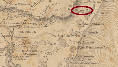
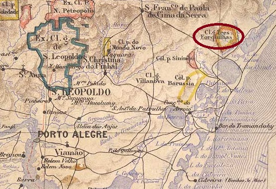
Trez Forquilhas (Three Forks) was the name of the settlement that emerged in the mid-19th century near Torres, 150 km northeast of the provincial capital Porto Alegre. It was not until September 1892 that the place was elevated to the status of a district, which subsequently changed its name twice: in March 1938 to Tres Irmãos and in December 1944 to Guananazes. Then, in July 1958, the original place name returned. Três Forquilhas has been an independent município since March 1992.
There had been a post office there since 1883, as can be read in the Directory of Imperial Post Offices (Tabella das Agencias do Correio do Imperio, Rio de Janeiro, 1885). The imperial postmark is TRS-0460a (image from the Internet): a double circle with the inscription TREZ FORQUILHAS at the top. The dates in the middle originate from the period 1883-1907.
Estado do Rio Grande do Sul, 1891
Andere Namen: Três Irmãos, Guananazes
Trez Forquilhas (Drei Forken) hieß die Siedlung, die in der Mitte des 19. Jahrhunderts bei Torres entstand, 150 km nordöstlich der Provinzhauptstadt Porto Alegre entfernt. Erst im September 1892 wurde der Ort zum Distrikt erhoben, der danach den Namen zweimal wechselte: im März 1938 zu Tres Irmãos und im Dezember 1944 zu Guananazes. Im Juli 1958 kehrte dann der ursprüngliche Ortsname zurück. Três Forquilhas ist seit März 1992 ein eigenständiger Município.
Es gab dort ein Postamt seit 1883, wie im Verzeichnis der kaiserlichen Postämter (Tabella das Agencias do Correio do Imperio, Rio de Janeiro, 1885) zu lesen ist. Der kaiserliche Poststempel ist TRS-0460a (Abb. aus dem Internet): ein Doppelkreis mit der Inschrift TREZ FORQUILHAS oben. Die Daten in der Mitte entstammen dem Zeitraum 1883-1907.