Bellegard-Niemeyer: Carta Corographica da Provincia do Rio de Janeiro, 1867
See also São José da Boa Morte (SRJ-0948)
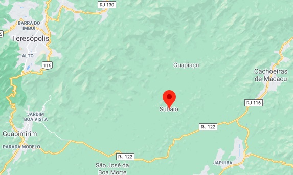
Subaio was the name of a small settlement near Santo Antonio de Sá, about 100 km northeast of the capital Rio de Janeiro, after a mountain range nearby. From about 1877, the village passed as a parish of the Freguesia of São José da Boa Morte to the Município of Sant’Anna de Macacu, and in May 1892 it was elevated to the status of a district, which today is in the Município of Cachoeiras de Macacu.
No less than three dates of foundation for the local post office have been found for the place, a clear sign that it was closed in the meantime. Paulo Novaes (agenciaspostais.com.br) gives the earliest date as October 1868. Then, another opening was announced in March 1869 by the Rio press:
Jornal do Commercio, 20.03.1869
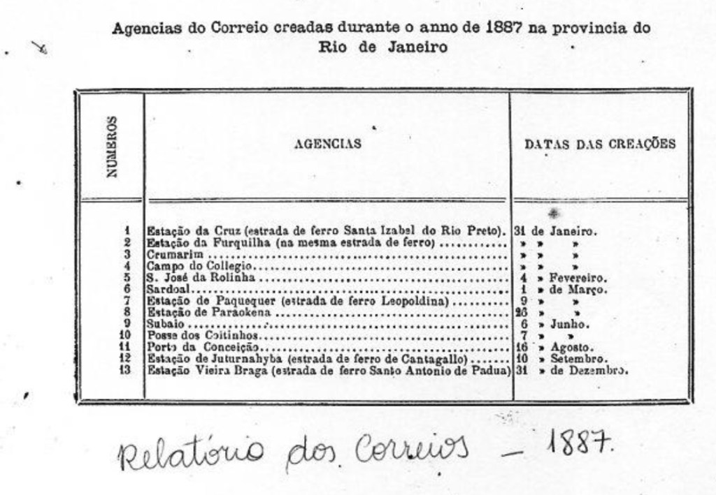
Since the post office was not mentioned either in the postal guide (Guia Postal do Império do Brazil, Rio de Janeiro, 1880) or in the 1885 Mail Register (Tabella das Agencias do Correio do Imperio, Rio de Janeiro), we assume that it was closed for a long time. Finally, the postal report for 1887 lists this agency as opening in June 1887:
Relatorio dos Correios, 1887
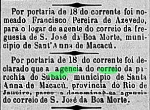
However, the post office was renamed São José da Boa Morte shortly after the third opening, according to the press:
Gazeta da Tarde, 20.07.1887
So far, no imperial-era postmark from this place has been found.
Google Maps
Siehe auch São José da Boa Morte (SRJ-0948)
Subaio hieß – nach einem Gebirge in der Nähe – eine kleine Siedlung bei Santo Antonio de Sá, die ca. 100 km nordöstlich der Hauptstadt Rio de Janeiro lag. Ab ca. 1877 ging der Ort als Pfarrei der Freguesia von São José da Boa Morte zum Município von Sant’Anna de Macacu über und wurde im Mai 1892 zum Distrikt erhoben, der heute im Município von Cachoeiras de Macacu liegt.
Nicht weniger als drei Gründungsdaten fürs örtliche Postamt wurden für den Ort gefunden. Ein klares Indiz dafür, dass es zwischendurch geschlossen war. Paulo Novaes (agenciaspostais.com.br) gibt den frühesten Termin an: Oktober 1868. Dann wurde durch die Presse aus Rio eine weitere Eröffnung im März 1869 bekannt gegeben:
Jornal do Commercio, 20.03.1869
Da das Postamt weder im Postführer (Guia Postal do Império do Brazil, Rio de Janeiro, 1880) noch im Verzeichnis der kaiserlichen Postämter (Tabella das Agencias do Correio do Imperio, Rio de Janeiro) von 1885 genannt wurde, gehen wir davon aus, dass es lange geschlossen war. Schließlich listet der Postbericht für 1887 diese Agentur mit Eröffnung im Juni 1887 auf:
Relatorio dos Correios, 1887
Allerdings wurde das Postamt kurz nach der dritten Eröffnung zu São José da Boa Morte umbenannt, wie die Presse mitteilte:
Gazeta da Tarde, 20.07.1887
Bisher wurde kein Poststempel der Kaiserzeit aus diesem Ort gefunden.
This was the old settlement of Santo Antonio do Pessanha near Serro, situated close to the north bank of the Suaçuí Pequeno River, 350 km north of the provincial capital of Ouro Preto. In October 1875, it became a vila called Rio Doce. This name was apparently not well received, because barely six years later the place rose to become a town called Suassuhy. The Indian word means River of the Deer. Since September 1887, the town has been called Pessanha, now spelled Peçanha.
Paula Sobrinho (História Postal de Minas Gerais, Belo Horizonte, 1997) and Reinhold Koester (Carimbologia XXI) agree that there had been a post office there since October 1875, when the villa was created. The only imperial postmark so far is SMG-3153a (Coll. José A. Junges): a double circle, which also occurs in red, with the inscription CIDADE DE SUSSSUHY above and an ornament in a cross with broad wings below. The only specimen bears a date of 1886 in the centre. Since the town – which did not exist before 1881 – was explicitly mentioned, one must assume that all earlier postmarks, for the Vila, existed under Pessanha, as Koester informs.
Provincia de Minas Geraes, 1873
Anderer Name: Santo Antonio do Pessanha
Siehe auch Pessanha (R. Koester: Carimbologia XXXI)
Diese Ortschaft war die alte Siedlung von Santo Antonio do Pessanha bei Serro, die nah am Nordufer des Flusses Suaçuí Pequeno lag, 350 km nördlich der Provinzhauptstadt Ouro Preto entfernt. Im Oktober 1875 wurde daraus eine Vila namens Rio Doce. Diese Bezeichnung kam offenbar nicht gut an, denn knapp sechs Jahre später stieg der Ort zu einer Stadt namens Suassuhy auf. Das indianische Wort bedeutet Fluss der Rehe. Seit September 1887 heißt die Stadt Pessanha, heute Peçanha geschrieben.
Paula Sobrinho (História Postal de Minas Gerais, Belo Horizonte, 1997) und Reinhold Koester (Carimbologia XXI) sind sich darüber einig, dass es dort seit Oktober 1875 – also seit der Entstehung der Villa – ein Postamt gab. Der einzige kaiserliche Poststempel bisher ist SMG-3153a (Samml. José A. Junges): ein auch in rot vorkommender Doppelkreis mit der Inschrift CIDADE DE SUSSSUHY oben und einem Ornament in Kreuz mit breiten Flügeln unten. Das einzige Exemplar trägt ein Datum von 1886 in der Mitte. Da die Stadt – die erst ab 1881 gab – dabei ausdrücklich erwähnt wurde, muss man annehmen, dass alle früheren Stempel von dort (für die Vila) unter Pessanha liefen, wie Koester schreibt.
Souza (now spelled Sousa) was already a freguesia in March 1784, located on the south bank of the Rio de Peixe, more than 400 km west of the later provincial capital of Parahyba do Norte (now João Pessoa). The village rose to the status of vila in June 1800 and to town in July 1854.
Both Nova Monteiro (Administrações e Agencias Postaes do Brasil Imperio, in Brasil Filatelico/RJ, 1934-5; Reprint SPP 1994-1999) and the Imperial Mail Register (Tabella das Agencias do Correio do Imperio, Rio de Janeiro, 1885) agree that there had been a post office there since May 1829. Only one 19th century postmark was found, certainly not the oldest: SPB-0245c (Coll. José A. Junges) is a plain double circle with the inscription SOUZA at the top. The dates in the middle go from 1888 to at least 1894.
Villiers de l’Ile Adam: Carta (…) das Provincias do Rio Grande do Norte e Parahiba, 1848
Andere Namen: Jardim do Rio do Peixe, Sousa
Souza (heute Sousa geschrieben) war bereits im März 1784 eine Freguesia, die am Südufer des Rio de Peixe lag, über 400 km westlich der späteren Provinzhauptstadt Parahyba do Norte (heute João Pessoa) entfernt. Im Juni 1800 stieg der Ort zur Vila und im Juli 1854 zur Stadt auf.
Sowohl Nova Monteiro (Administrações e Agencias Postaes do Brasil Imperio, in Brasil Filatelico/RJ, 1934-5; Reprint SPP 1994-1999) als auch das Verzeichnis der kaiserlichen Postämter (Tabella das Agencias do Correio do Imperio, Rio de Janeiro, 1885) stimmen darüber überein, dass es dort bereits seit Mai 1829 ein Postamt gab. Nur ein Poststempel des 19. Jahrhunderts wurde gefunden, bestimmt nicht der älteste: SPB-0245c (Samml. José A. Junges) ist ein schlichter Doppelkreis mit der Inschrift SOUZA oben. Die Daten in der Mitte gehen von 1888 bis mindestens 1894.
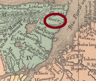
Soure (also spelled Soire) was again a settlement in the Grão-Pará area, named after a Portuguese community. Located in northeast of Marajó Island, just under 100 km north of the capital Belém do Pará. As early as June 1755, the village became a vila, which was then demoted to a freguesia in 1833, only to rise again as a vila in September 1847. Soure has been a town since September 1890.
It can be assumed that there was a post office there from around 1861, because in January 1862 a postal agent was posted there, as can be seen from a ministerial release:
Expediente Ministerio da Agricultura/RJ, 03.01.1862
Only one 19th century postmark was found, probably not the oldest: SPA-0240b (Coll. Euclides Oliveira) is a double circle with the inscriptions SOIRE above and (I) below. The only specimen bears a date from 1891 in the centre.
Villiers de l’Ile Adam: Carta (…) das Provincias do Grão Pará e Alto Amazonas, 1850
Soure (auch Soire geschrieben) war wieder eine Siedlung im Gebiet Grão-Pará, die nach einer portugiesischen Gemeinde genannt wurde. Sie lag im Nordosten der Marajó-Insel, knapp 100 km nördlich der Hauptstadt Belém do Pará entfernt. Bereits im Juni 1755 wurde der Ort eine Vila, die dann 1833 zur Freguesia degradiert wurde, um im September 1847 wieder als Vila aufzusteigen. Seit September 1890 ist Soure eine Stadt.
Es ist anzunehmen, dass es dort seit ca.1861 ein Postamt gab, denn im Januar 1862 wurde ein Postagent dorthin abkommandiert, wie aus einer ministerialen Mitteilung hervorgeht:
Expediente Ministerio da Agricultura/RJ, 03.01.1862
Nur ein Poststempel des 19. Jahrhunderts wurde gefunden, wohl nicht der älteste: SPA-0240b (Samml. Euclides Oliveira) ist ein Doppelkreis mit den Inschriften SOIRE oben und (I) unten. Das einzige Exemplar trägt ein Datum aus 1891 in der Mitte.
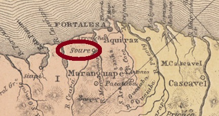
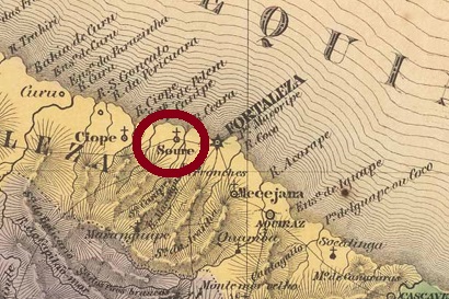
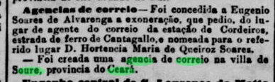
Vila Nova de Soure was the name of the town as early as 1759. It was only a good 15 km west of the future provincial capital Fortaleza. This proximity did the settlement no good; it was relegated four times as a district of the capital (1833, 1835, 1870 and 1898), only to rise again four times as a vila (1833, 1860, 1878 and 1903). Since December 1943, the Município has been called Caucaia. The word from the Indian language means burnt forest.
As can be read in the press from Rio de Janeiro, there was a post office there since October 1887:
Jornal do Commercio/RJ, 19.10.1887
However, the place was already mentioned in postal routes of the 1870s. Possibly there had been a postal agency there for a short period of time. So far, no postmark from the imperial period could be identified with certainty for this locality.
Villiers de l’Ile Adam: Carta (…) da Provincia do Ceará, 1849
Anderer Name: Caucaia
Vila Nova de Soure hieß bereits 1759 der Ort, der nur gut 15 km westlich der künftigen Provinzhauptstadt Fortaleza entfernt lag. Diese Nähe tat der Siedlung nichts Gutes, sie stieg viermal als Distrikt der Hauptstadt ab (1833, 1835, 1870 und 1898), um auch viermal als Vila wieder aufzusteigen (1833, 1860, 1878 und 1903). Seit Dezember 1943 heißt der Município Caucaia. Das Wort aus der Indianersprache bedeutet abgebrannter Wald.
Wie in der Presse aus Rio de Janeiro zu lesen ist, gab es dort ein Postamt seit Oktober 1887:
Jornal do Commercio/RJ, 19.10.1887
Allerdings wurde der Ort bereits in Postrouten der 1870er Jahre erwähnt. Womöglich hatte es dort früher eine Postagentur für eine kurze Periode gegeben. Bisher konnte kein Poststempel aus der Kaiserzeit mit Sicherheit für diese Ortschaft identifiziert werden.
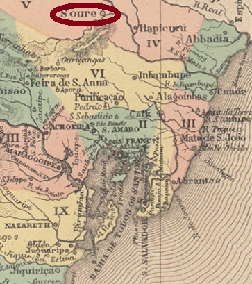
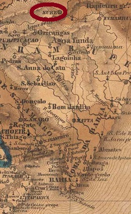
The Freguesia of Nossa Senhora da Conceição do Soure was created in May 1758 by royal decree (Provisão Real) and was located close to the south bank of the river Itapicuru, 250 km north of the future provincial capital Salvador da Bahia. Just 9 months later, the place was a villa. Later, it was twice demoted to the district of Cipó: in July 1931 and in December 1943. In between – more precisely in July 1935 – Soure became a Município. Political autonomy returned in June 1944, now under the name of Nova Soure.
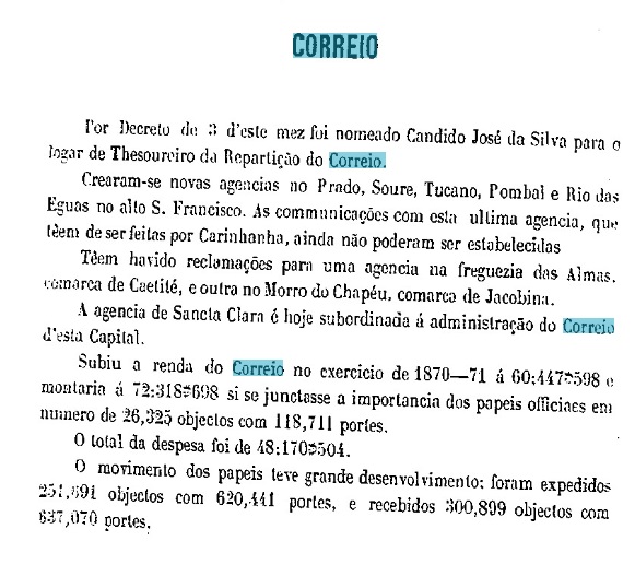
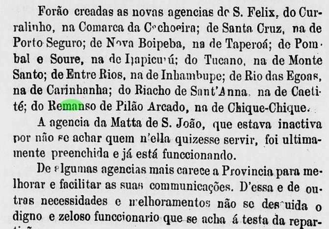
Two dates of origin for the local post office were found, 1872 and 1875, both documented by the provincial president’s report:
Relatorio do Presidente da Provincia, 03/1872Relatorio do Conselho do Governo, 1876
An early postmark has been found, certainly not the first: SBA-0720b (image from the internet) is a double circle with the inscriptions SOURE above and (BAHIA) below. The only known example has a date from 1903 in the middle.
Villiers de l’Ile Adam: Carta (…) da Provincia da Bahia, 1848
Anderer Name: Nova Soure (1944)
Die Freguesia von Nossa Senhora da Conceição do Soure entstand im Mai 1758 durch königliche Verfügung (Provisão Real) und lag nah am Südufer des Flusses Itapicuru, 250 km nördlich der künftgen Provinzhauptstadt Salvador da Bahia entfernt. Bereits 9 Monaten später war der Ort eine Villa. Später wurde er zweimal zum Distrikt von Cipó degradiert: im Juli 1931 und im Dezember 1943. Dazwischen – genauer im Juli 1935 – wurde Soure ein Município. Auch im Juni 1944 kam der politische Aufstieg, nun unter dem Namen Nova Soure.
Zwei Entstehungstermine fürs örtliche Postamt wurden gefunden, 1872 und 1875, jeweils durch den Bericht des Provinzpräsidenten dokumentiert:
Relatorio do Presidente da Provincia, 03/1872Relatorio do Conselho do Governo, 1876
Ein früher Poststempel wurde gefunden, sicher nicht der erste: SBA-0720b (Abb. aus dem Internet) ist ein Doppelkreis mir den Inschriften SOURE oben und (BAHIA) unten. Das einzig bekannte Exemplar hat ein Datum aus 1903 in der Mitte.
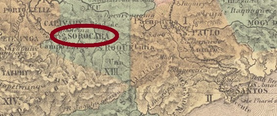
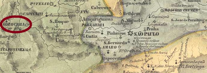
The freguesia of Nossa Senhora da Ponte de Sorocaba (Our Lady of Sorocaba Bridge) was established as early as 1654 and was located on the west bank of the Sorocaba River, 100 km west of the future provincial capital of São Paulo. The town grew very quickly and soon became Brazil’s most important transhipment point for livestock. In March 1661 Sorocaba rose to the status of a villa and in February 1842 to that of a city. The local railway station was inaugurated in July 1875 by the E.F. Sorocabana railway company and remained in operation until 1998, after changing hands several times: to the Cia. União Sorocabana e Ytuana (1892), Sorocabana Railway (1907), back to E.F. Sorocabana (1919) and finally to FEPASA (1971).
Two creation dates for the local post office have been found. Nova Monteiro, in Administrações e Agencias Postaes do Brasil Imperio (Brasil Filatelico/RJ, 1934-5; Reprint SPP 1994-1999) writes October 1839 for it, while the agency is listed in the Imperial Mail Register (Tabella das Agencias do Correio do Imperio, Rio de Janeiro, 1885) from 1846. According to this, it would have been closed in between. However, the RHM catalogue reports pre-philatelic postmarks from Sorocaba that would have been in circulation as early as around 1827. A third, earliest post office opening seems to be proven by this.
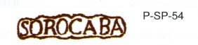
The earliest postmark is therefore SSP-1395a, as illustrated in the RHM catalogue:
SSP-1395a (RHM P-SP-54) 1827-1829
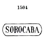
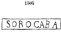
It was followed by two postmarks, SSP-1395b and SSP-1395c, which also occur in red and were introduced to us by Paulo Ayres in Catálogo de Carimbos Brasil-Império, (S. Paulo, 1937, 1942) under Nos. 1505 and 1504 respectively:
The following cancels are double circles. SSP-1395d also exists in blue and was also introduced by P. Ayres:
SSP-1395d (P.A. p. 118) 1868-1880
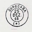
On SSP-1395e (Coll. Mario Celso Orsi Jr.) the above inscription is SOROCABA. The cancel also appears in violet, and the inner dates go from 1881 to 1890. SSP-1395f (Coll. José A. Junges) has the same inscription at the top, with a five-pointed star at the bottom. Dates: 1885-1888. SSP-1395g (Coll.José A. Junges) also has the same inscription at the top, but now reads (S.PAULO) at the bottom. Dates: 1885-1897. SSP-1395h (Coll. José A. Junges) has a cruciform ornament at the bottom, with the same inscription at the top. Dated 1889-1894 in the centre. SSP-1396a (Coll. Mario Celso Orsi Jr.) was intended for ambulant mail service in railway carriages. The double circle reads SOROCABA above and (C.A.) below, for Correio Ambulante. Dated 1885-1887 in the centre.
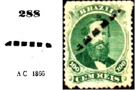
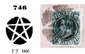
Below the many “mute” postmarks from Imperial Sorocaba, two have already been presented by P. Ayres (op. cit.) under Nos. 288 and 746:
P. Ayres 288 (Coll. M. Orsi Jr.) 1866ffP. Ayres 746 (Coll. José A. Junges) 1866ff-1883
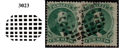
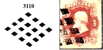
Two further postmarks were given the nos. 3023 and 3110 in Mute Cancellations of the Brazil Empire, by J. Dingler and K.W. Lopes (Brazil Philatelic Association, Rio de Janeiro, 2000):
BPA 3023 (Coll. M. Orsi Jr.) 1867-1869BPA 3110 (Coll. M. Orsi Jr.) 1876
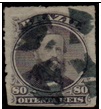
Another one was found on a D.Pedro issue of1876 :
(Coll. M. Orsi Jr.) 1876ffVilliers de lÌle Adam: Carta (…) da Provincia de São Paulo, 1847
Anderer Name: Nossa Senhora da Ponte de Sorocaba
Die Freguesia von Nossa Senhora da Ponte de Sorocaba (Unsere Liebe Frau an der Sorocaba-Brücke) entstand bereits 1654 und lag am Westufer des Flusses Sorocaba, 100 km westlich der künftigen Provinzhauptstat São Paulo entfernt. Die Ortschaft wuchs sehr schnell und wurde bald Brasiliens wohl wichtigster Umschlagplatz für Vieh. Im März 1661 stieg Sorocaba zur Villa und im Februar 1842 zur Stadt auf. Der örtliche Bahnhof wurde im Juli 1875 von der Bahngesellschaft E.F. Sorocabana eingeweiht und blieb bis 1998 in Betrieb, nachdem die Besitzer mehrmals wechselten: zur Cia. União Sorocabana e Ytuana (1892), Sorocabana Railway (1907), zurück zur E.F. Sorocabana (1919) und schließlich zur FEPASA (1971).
Zwei Gründungsdaten fürs örtliche Postamt wurden ermittelt. Nova Monteiro schreibt in Administrações e Agencias Postaes do Brasil Imperio (Brasil Filatelico/RJ, 1934-5; Reprint SPP 1994-1999) dafür den Oktober 1839, während die Agentur im Verzeichnis der kaiserlichen Postämter (Tabella das Agencias do Correio do Imperio, Rio de Janeiro, 1885) ab 1846 aufgelistet wird. Demnach wäre sie zwischendurch geschlossen gewesen. Allerdings berichtet der RHM-Katalog über Vorphila-Poststempel aus Sorocaba, die bereits um 1827 im Umlauf wären. Eine dritte, früheste Postamteröffnung scheint dadurch belegt zu sein.
Der früheste Poststempel ist also SSP-1395a, wie im RHM-Katalog abgebildet wurde:
Die folgenden Stempel sind Doppelkreise. SSP-1395d gibt es auch in blau und wurde ebenfalls durch P. Ayres bekannt gemacht:
SSP-1395d (P.A. p./S. 118) 1868-1880
Bei SSP-1395e (Samml. Mario Celso Orsi Jr.) lautet die obige Inschrift SOROCABA. Der Stempel kommt auch in violett vor, und die inneren Daten gehen von 1881 bis 1890. SSP-1395f (samml. José A. Junges) hat oben die gleiche Inschrift, unten sieht man einen fünfzackigen stern. Daten: 1885-1888. Auch SSP-1395g (Samml. José A. Junges) hat die gleiche Inschrift oben, unten steht nun (S.PAULO) zu lesen. Daten: 1885-1897. Im SSP-1395h (Samml. José A. Junges) ist unten ein kreuzförmiges Ornament, bei gleicher Inschrift oben. Datiert 1889-1894 in der Mitte. SSP-1396a (Samml. Mario Celso Orsi Jr.) war für den ambulanten Postbetrieb im Bahnwagen betimmt. Im Doppelkreis liest man oben SOROCABA und unten (C.A.), für Correio Ambulante. Datiert 1885-1887 in der Mitte.
Unten den vielen “stummen” Poststempel aus dem kaiserlichen Sorocaba wurden zwei bereits durch P. Ayres (op. cit.) unter den Nr. 288 und 746 präsentiert:
P. Ayres 288 (Samml. M. Orsi Jr.) 1866ffP. Ayres 746 (Samml. José A. Junges) 1866ff-1883
Zwei weitere Stempel haben die Nr. 3023 und 3110 im Mute Cancellations of the Brazil Empire/ Carimbos Mudos do Brasil Império, von J. Dingler und K.W. Lopes (Brazil Philatelic Association, Rio de Janeiro, 2000) bekommen:
BPA 3023 (Samml. M. Orsi Jr.) 1867-1869BPA 3110 (Samml. M. Orsi Jr.) 1876
Ein weiterer wurde auf einer D. Pedro-Ausgabe von 1876 gefunden :
Other names: Descoberto do Itagybá, Soledade, Delfim Moreira (1938)
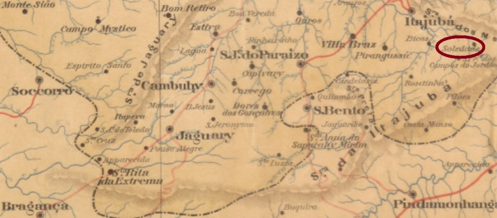
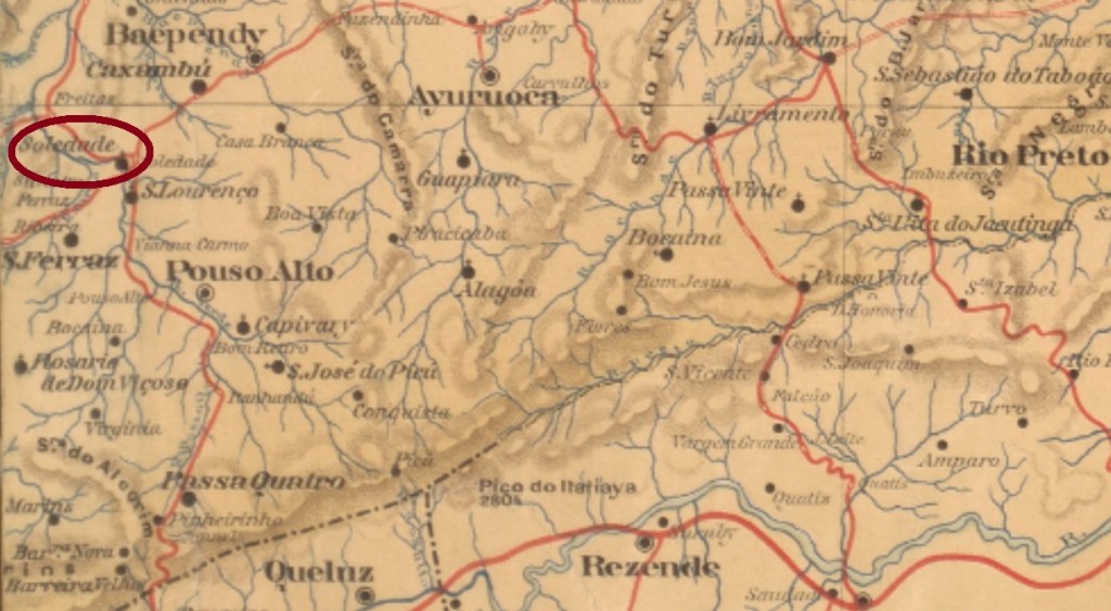
This locality was the old freguesia called Descoberto near Itajubá from November 1762 and was situated close to the border with São Paulo, over 440 km southwest of the provincial capital Ouro Preto. The name Soledade do Itajubá came in November 1842, then in September 1848 it is said to have been called Boa Vista do Itajubá, and since December 1938 it has been the Município of Delfim Moreira. The name reminds a politician from Minas Gerais (1868-1920) who was acting president of Brazil for 8 months from November 1918, after the elected president Rodrigues Alves fell ill with the Spanish flu and died.
As Paula Sobrinho writes in História Postal de Minas Gerais (Belo Horizonte, 1997), there was a post office in Soledade do Itajubá from July 1869. A postmark was found, probably not the oldest one from there: SMG-3145b (Coll. José A. Junges) has a double circle with the inscription SOLIDADE (sic) DO ITAJUBÁ on top. The only specimen so far bears a date from 1885 inside.
Atlas do Imperio do Brasil, 1868
Andere Namen: Descoberto do Itagybá, Soledade, Delfim Moreira (1938)
Diese Ortschaft war ab November 1762 die alte Freguesia namens Descoberto bei Itajubá und lag nah an der Grenze zu São Paulo, über 440 km südwestlich der Provinzhauptstadt Ouro Preto entfernt. Der Name Soledade do Itajubá kam im November 1842. Im September 1848 soll sie dann Boa Vista do Itajubá geheißen haben, und seit Dezember 1938 ist es der Município von Delfim Moreira. Der Name erinnert an einem Politiker aus Minas Gerais (1868-1920), der ab November 1918 8 Monate lang kommissarischer Präsident Brasiliens war, nachdem der gewählte Präsident Rodrigues Alves an der Spanischen Grippe erkrankte und starb.
Wie Paula Sobrinho in História Postal de Minas Gerais (Belo Horizonte, 1997) schreibt, gab es in Soledade do Itajubá ab Juli 1869 ein Postamt. Ein Poststempel wurde gefunden, wahrscheinlich nicht der Älteste von dort: SMG-3145b (Samml. José A. Junges) ist ein Doppelkreis mit der Inschrift SOLIDADE (sic) DO ITAJUBÁ oben. Das bisher einzige Exemplar trägt ein Datum aus 1885 im Inneren.
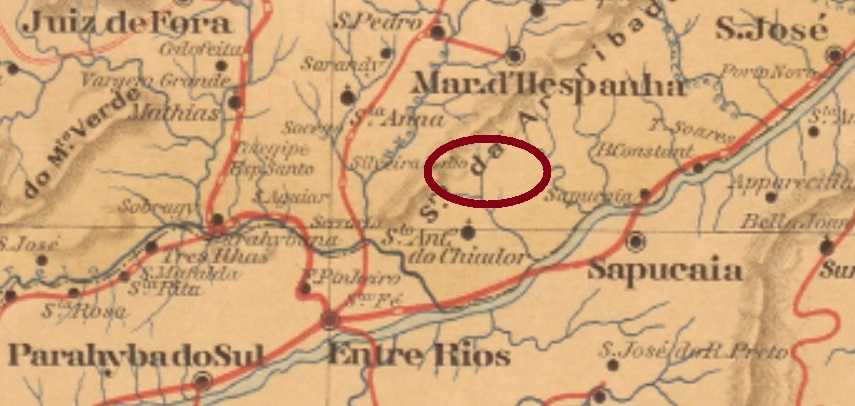
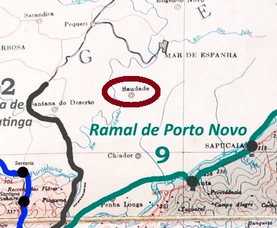
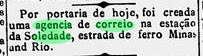
This other locality called Soledade in the province of Minas was a district of Mar d’Hespanha from May 1890, situated over 280 south of the capital Ouro Preto. Since September 1923, the district has been called Saudade (Longings).
As Paula Sobrinho writes in História Postal de Minas Gerais (Belo Horizonte, 1997), there was a post office there from December 1887. Two 19th century postmarks in the double circle were found. SMG- 3150a (Coll. José A. Junges) has the inscription SOLEDADE DO CHIADOR at the top, while (MINAS) can be read at the bottom. Its successor SMG-3150b (Coll. José A. Junges) no longer has an inscription at the bottom, but only an ornament in lozenge. The only specimen so far bears a date from 1889 in the centre.
agenciaspostais.com.br
Andere Namen: Soledade, Saudade (1923)
Diese andere Ortschaft namens Soledade in der Provinz Minas war ab Mai 1890 ein Distrikt von Mar d’Hespanha, der über 280 km südlich der Hauptstadt Ouro Preto entfernt lag. Seit September 1923 heißt der Distrikt Saudade (Sehnsucht).
Wie Paula Sobrinho in História Postal de Minas Gerais (Belo Horizonte, 1997) schreibt, gab es dort ab Dezember 1887 ein Postamt. Zwei Poststempel des 19. Jahrhunderts im Doppelkreis wurden gefunden. SMG- 3150a (Samml. José A. Junges) hat oben die Inschrift SOLEDADE DO CHIADOR, während unten (MINAS) zu lesen ist. Sein Nachfolger SMG-3150b (Samml. José A. Junges) hat unten keine Inschrift mehr, sondern nur noch ein Ornament in Raute. Das bisher einzige Exemplar trägt ein Datum aus 1889 in der Mitte.
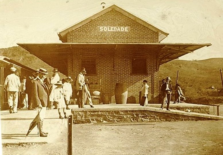
Other names: Soledade da Campanha, Ibatuba, Soledade de Minas (1948)
The Soledade station in the province of Minas Gerais was inaugurated in June 1884 by the E.F. Minas e Rio railway company and was located on the Cruzeiro-Jureia line near Baependy, almost 340 km southwest of the capital Ouro Preto. The railway line changed hands several times: Rede Sul-Mineira (1910), Rede Mineira de Viação (1931), Viação Férrea Centro-Oeste (1965), Rede Ferroviária Federal S.A. (1975) and most recently ABPF (2000). Since December 1948, the station has been located in the Município of Soledade de Minas (estacoesferroviarias.com.br).
The station post office was created in September 1884, as reported by the Rio press:
Gazeta da Tarde/RJ, 13/09/1884
The only imperial postmark so far is SMG-3140a (Coll. Dieter Kerkhoff): a double circle with the inscriptions SOLEDADE above and (ESTAÇĀO) below. The dates inside are from the period 1885-1891.
ca.1910 (estacoesferroviarias.com.br)
Andere Namen: Soledade da Campanha, Ibatuba, Soledade de Minas (1948)
Der Bahnhof Soledade in der Provinz Minas Gerais wurde im Juni 1884 durch die E.F. Minas e Rio Bahngesellschaft eingeweiht und lag auf der Linie Cruzeiro-Jureia bei Baependy, knapp 340 km südwestlich der Hauptstadt Ouro Preto entfernt. Die Bahnlinie wechselte mehrmals den Besitzer: Rede Sul-Mineira (1910), Rede Mineira de Viação (1931), Viação Férrea Centro-Oeste (1965), Rede Ferroviária Federal S.A. (1975) und zuletzt ABPF (2000). Seit Dezember 1948 liegt der Bahnhof im Município von Soledade de Minas (estacoesferroviarias.com.br).
Das Bahnhofspostamt entstand im September 1884, wie die Presse aus Rio berichtet:
Gazeta da Tarde/RJ, 13.09.1884
Der bisher einzige kaiserliche Poststempel ist SMG-3140a (Samml. Dieter Kerkhoff): ein Doppelkreis mit den Inschriften SOLEDADE oben und (ESTAÇĀO) unten. Die Daten im Inneren entstammen dem Zeitraum 1885-1891.