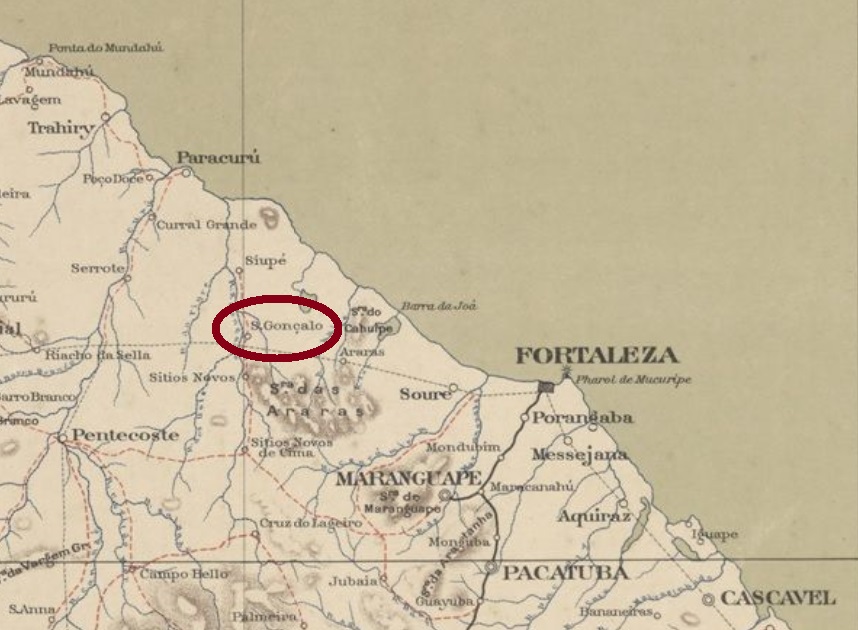
Other names: Paracuru, S. Gonçalo do Amarante (1953), Anacetaba (1943-53)
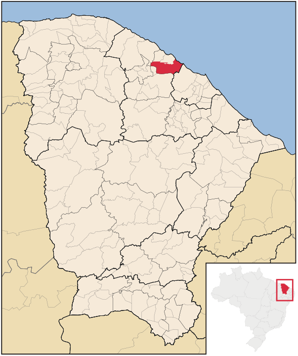
This village was originally a settlement in the district of Paracuru, municipality of Trahiry, situated about 60 km west of the provincial capital Fortaleza. It was not until October 1890 that it became a district, but as early as November 1921, the town had its own municipality. Since then, the place name changed twice: in December 1943 to Anacetaba, and in November 1953 to the current São Gonçalo do Amarante.
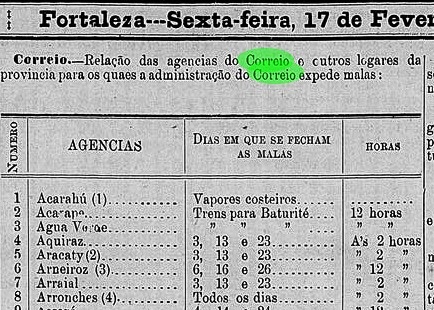
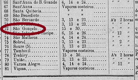
It is still not entirely clear whether there was a post office here during the imperial period of Brazil, because the evidence is rather thin. However, since this village appears in a list of Ceará post offices, which has been published in the provincial press, it remains here subject to confirmation:
Cearense, 17 February 1887
Until now, no postmark of the imperial period could be assigned to this municipality.
Raphael Lorenzeto de Abreu, CC_BY_2.5
Buchtext-Aktualisierung vom 2. März 2021
Andere Namen: Paracuru, S. Gonçalo do Amarante (1953), Anacetaba (1943-53)
Diese Ortschaft war ursprünglich eine Siedlung im Distrikt von Paracuru, Município von Trahiry, und lag gut 60 km westlich der Provinzhauptstadt Fortaleza. Erst im Oktober 1890 wurde daraus ein Distrikt, aber bereits im November 1921 hatte São Gonçalo einen eigenen Município. Seitdem wechselte der Ortsname zweimal: im Dezember 1943 zu Anacetaba, und im November 1953 zum aktuellen São Gonçalo do Amarante.
Es ist bis heute nicht vollkommen klar, ob es hier in der Kaiserzeit Brasiliens ein Postamt gab, denn die Beweislage ist eher dünn. Da aber diese Ortschaft in einer Liste der Ceará-Postämter auftaucht, die in der Provinzpresse veröffentlicht wurde, bleibt sie hier unter Vorbehalt:
Cearense, 17. Februar 1887
Bisher konnte kein Poststempel der Kaiserzeit dieser Gemeinde zugeordnet werden.
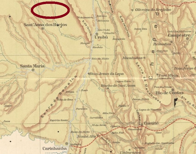
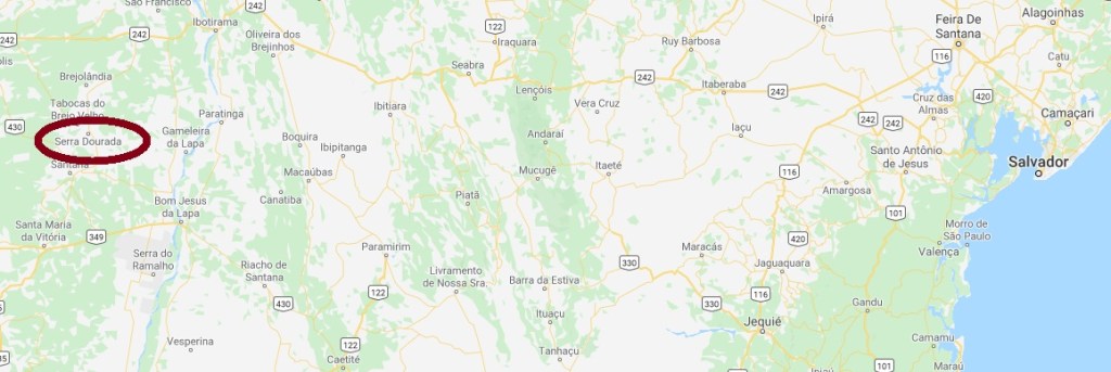
Other names: Sao Gonçalo dos Brejos, Penamar (1938), Serra Dourada (1962)
The history of this village began in 1868, with the settlement of São Gonçalo dos Brejos (= on the swamps) in the municipality of Santa Maria da Victoria, about 800 km west of the provincial capital Salvador da Bahia. Until 1881, it was an Arraial in the municipality of Carinhanha, before moving to the newly founded municipality of Sant’Anna dos Brejos in 1890. It was not until August 1906 that the district status was granted. Two toponym changes followed: in November 1938 to Penamar and in July 1962 to the current Serra Dourada (= Golden Mountains), when political emancipation came. As you can see, a literal rise in naming took place over time.
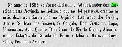
The local post office was created in 1883, as can be seen from the provincial president’s report for 1884:
Relatorio do Conselho Interino do Governo da Bahia, 1884
Until now, no postmark of the imperial era could be doubtless assigned to this locality.
Google Maps
Andere Namen: São Gonçalo dos Brejos, Penamar (1938), Serra Dourada (1962)
Die Geschichte dieser Ortschaft fing ab ca. 1868 an, mit der Siedlung von São Gonçalo dos Brejos (= der Sümpfe) im Município von Santa Maria da Victoria, ca. 800 km westlich der Provinzhauptstadt Salvador da Bahia entfernt. Bis 1881 war sie dann ein Arraial im Município von Carinhanha, bevor sie 1890 zur frisch gegründeten Gemeinde von Sant’Anna dos Brejos wechselte. Erst im August 1906 kam der Distrikt-Status. Es folgten zwei Änderungen des Ortsnamens: im November 1938 zu Penamar und im Juli 1962 zur aktuellen Serra Dourada (= Goldenes Gebirge), als die politische Emanzipation kam. Wie man sieht, ein buchstäblicher Aufstieg in der Namensgebung fand im Laufe der Zeit statt.
Das örtliche Postamt entstand 1883, wie man aus dem Bericht des Provinzpräsidenten für 1884 entnehmen kann:
Relatorio do Conselho Interino do Governo da Bahia, 1884
Bisher konnte kein Poststempel der Kaiserzeit zweifelsfrei dieser Gemeinde zugeordnet werden.
Carta da Republica dos Estados Unidos do Brazil, 1892
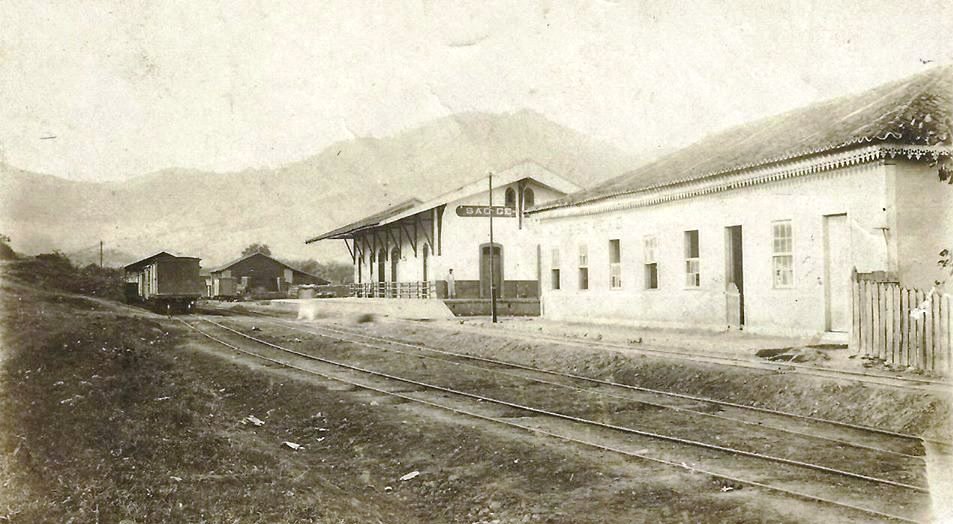
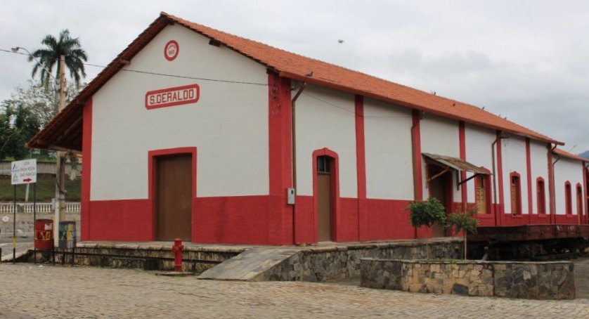
This station was inaugurated in March 1880 by the E.F. Leopoldina Railway Company on the Caratinga Line and was situated in the municipality of Presídio de Ubá (= Ubá’s prison, now Visconde de Rio Branco), about 150 km southeast of the provincial capital Ouro Preto. The line was transferred in 1975 to the state-run Rede Ferroviária Federal S.A. and remained in operation until 1996. Today the station has been restored.
The train station around 1940…… and in 2016 (Photo: Prefeitura Municipal, in estacoesferroviarias.com.br)
A settlement grew around the station. In 1882 it became a district, and since December 1948 it has been an independent municipality.
The local post office was built in July 1878, as reported by Paula Sobrinho (História Postal de Minas Gerais, Belo Horizonte, 1997). A postmark of the imperial period was found: SMG-2295a (Coll. Karlheinz Wittig) occurs also in purple and has a double circle with the inscription S. GERALDO (ESTAÇÃO). The dates at the centre are sometimes partly written by hand and vary from 1885 to 1898.
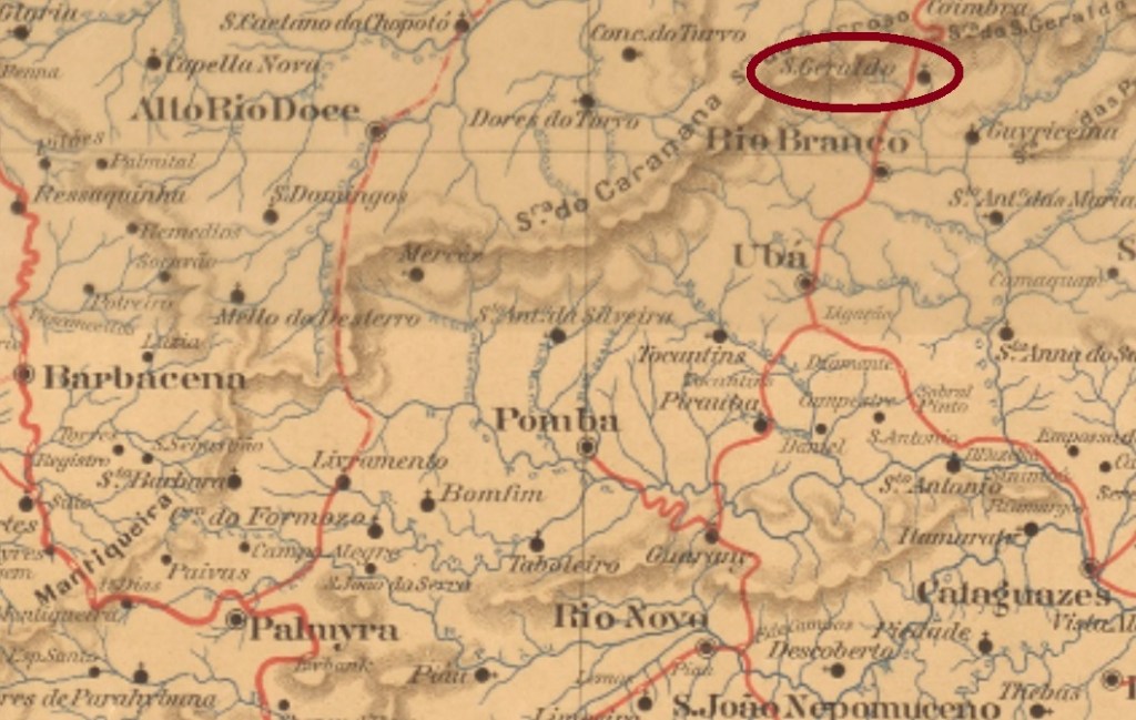
Mappa de Minas Geraes, 1910
Dieser Bahnhof wurde im März 1880 durch die E.F. Leopoldina Eisenbahngesellschaft in der Caratinga-Linie eingeweiht und lag im Município von Presídio de Ubá (= Ubás Gefängnis, heute Visconde de Rio Branco), ca. 150 km südöstlich der Provinzhauptstadt Ouro Preto entfernt. Die Linie ging 1975 an die staatliche Rede Ferroviária Federal S.A. über und blieb in Betrieb bis 1996. Heute ist der Bahnhof restauriert.
Der Bahnhof um 1940……und 2016 (Foto: Prefeitura Municipal, in estacoesferroviarias.com.br)
Um den Bahnhof herum wuchs eine Siedlung. 1882 wurde daraus ein Distrikt, seit Dezember 1948 ist São Geraldo ein eigenständiger Município.
Das örtliche Postamt entstand im Juli 1878, wie Paula Sobrinho berichtet (História Postal de Minas Gerais, Belo Horizonte, 1997). Ein Poststempel der Kaiserzeit war zu finden: SMG-2295a (Samml. Karlheinz Wittig) kommt auch in lila vor und hat einen Doppelkreis mit der Inschrift S. GERALDO (ESTAÇÃO). Die Daten in der Mitte sind mitunter teilweise per Hand geschrieben und gehen von 1885 bis 1898.
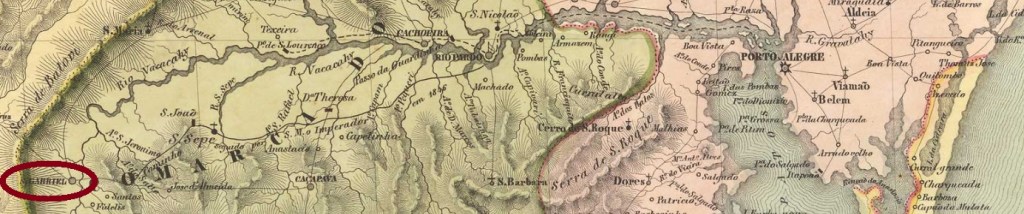
The parish of São Gabriel was situated in the municipality of Cachoeira, more than 300 km west of the provincial capital Porto Alegre. In December 1837, during the Farroupilha Revolution, it became a district and in April 1846, a villa. Since December 1859, São Gabriel has the town status.
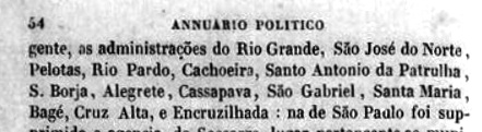
According to Nova Monteiro (Administrações e Agencias Postaes do Brasil Imperio, in Brasil Filatelico/RJ, 1934-5; Reprint SPP 1994-1999) there is a post office there since October 1831. However, it may have been closed during the Revolution (1835-1845), for an agency reopening is reported in the Yearbook for Politics, History and Statistics of Brazil for 1846:
Annuario Politico Historico e Estatistico do Brazil, 1846, pp 53-4
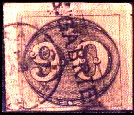
The year is confirmed by the Imperial Mail Register (Tabella das Agencias do Correio do Imperio) of 1885. The pre-philatelic cancel SRS-0315a may have been in use both in the first and the beginning of the second operating period (until at least 1866). It was presented in the RHM catalogue as P-RS-26, but a point after the S is missing, as can be seen in the following illustrations:
SRS-0315a, RHM P-RS-26SRS-0315a recte (FERREIRA, Henrique Bunselmeyer: Catálogo ilustrado dos carimbos sobre os olhos-de-boi, 4a. ed, Porto Alegre, 2017)
It was followed by SRS-0315b, a handwritten cancellation that was used in some variants from ca. 1850 until the 1876 D. Pedro issue:
SRS-0315b (Coll. José A. Junges)
SRS-0315c (Coll. José A. Junges) is again a “normal” cancel: a double circle with inscription SAO GABRIEL above. The dates at the centre are from the period approx. 1876-1879. SRS-0315d (Coll. Dieter Kerkhoff) is also available in green. Here the double circle is slightly larger, the inscription is now S. GABRIEL above, and below you can see a diamond-shaped ornament consisting of four small leaflets. Dated 1883-1890ff at the centre. SRS-0315e (Coll. José A. Junges) resembles a seal: a black double circle with inscriptions in negative: S. GABRIEL above and S.P. DO SUL below. The centre has remained free, without dates. Found on issues from 1884 to 1889. Finally, SRS-0315f (Coll. José A. Junges) is likely to be Republican, as it dates so far from 1892 on. Here the upper inscription in the double circle is S. GABRIEL, below one reads (S. PEDRO DO SUL), with date at the centre.
Villiers de l’Ile Adam: Carta (…) da Provincia de São Pedro do Sul, 1847
São Gabriel war eine Pfarrei im Município von Cachoeira, die über 300 km westlich der Provinzhauptstadt Porto Alegre entfernt lag. Im Dezember 1837 – also mitten in der Farroupilha-Revolution – wurde daraus ein Distrikt und im April 1846 eine Villa. Seit Dezember 1859 ist São Gabriel eine Stadt.
Laut Nova Monteiro (Administrações e Agencias Postaes do Brasil Imperio, in Brasil Filatelico/RJ, 1934-5; Reprint SPP 1994-1999) gibt es dort ein Postamt seit Oktober 1831. Allerdings durfte es während des Aufstands (1835-1845) geschlossen gewesen zu sein, denn im Jahrbuch für Politik, Geschichte und Statistik Brasiliens für 1846 wird über eine Wiedereröffnung des Postamts berichtet:
Annuario Politico Historico e Estatístico do Brazil, 1846, pp 53-4
Diese Jahresangabe wird durch das Verzeichnis der kaiserlichen Postämter (Tabella das Agencias do Correio do Imperio) von 1885 bestätigt. Der Vorphila-Stempel SRS-0315a dürfte sowohl in der ersten als auch am Anfang der zweiten Betriebsperiode (bis mindestens 1866) im Gebrauch gewesen sein. Er wurde im RHM-Katalog als P-RS-26 vorgestellt, allerdings fehlt ein Punkt nach dem S, wie man auf der darauffolgenden Abbildung sehen kann:
SRS-0315a, RHM P-RS-26SRS-0315a recte (FERREIRA, Henrique Bunselmeyer: Catálogo ilustrado dos carimbos sobre os olhos-de-boi, 4a. ed, Porto Alegre, 2017)
Ihm folgte SRS-0315b, eine handschriftliche Entwertung, die ab der Zifferausgabe vom 1850 bis zur D. Pedro-Ausgabe von 1876 in einigen Varianten benutzt wurde:
SRS-0315b, Sammlung José A. Junges
SRS-0315c (Samml. José A. Junges) ist wieder ein „normaler“ Stempel: ein Doppelkreis mit Inschrift SAO GABRIEL oben. Die Daten in der Mitte entstammen dem Zeitraum ca. 1876-1879. SRS-0315d (Samml. Dieter Kerkhoff) gibt es auch in grün. Hier ist der Doppelkreis etwas größer, die Inschrift lautet nun S. GABRIEL oben, und unten sieht man ein rautenförmiges Ornament, das aus vier kleinen Zweigen besteht. Datiert 1883-1890ff in der Mitte. SRS-0315e (Samml. José A. Junges) sieht eher wie ein Siegel aus: ein schwarzer Doppelkreis mit Inschriften im Negativ: S. GABRIEL oben und S.P. DO SUL unten. Die Mitte ist frei geblieben, ohne Datumsangaben. Angetroffen auf Ausgaben von 1884 bis 1889. Und SRS-0315f (Samml. José A. Junges) dürfte bereits republikanisch sein, da die bisherigen Daten ab 1892 aufweisen. Hier lautet die obere Inschrift im Doppelkreis S. GABRIEL, unten liest man (S. PEDRO DO SUL), dazu Datum in der Mitte.
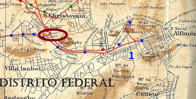
Linhas Ferroviárias do Distrito Federal, 1907 (in agenciaspostais.com.br)
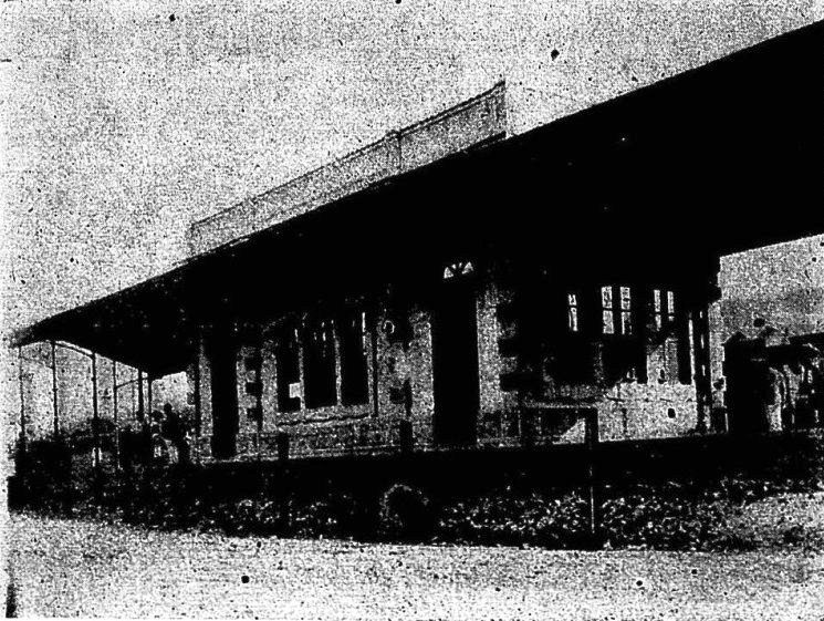
A rare case: this station in the urban area of Rio de Janeiro is still in operation today, 160 years later. It was inaugurated in 1861 by the E.F. Dom Pedro II Railway Company and was the fifth stop after the main station at the junction to Petropolis. After the end of the Empire, the railway line was renamed E.F. Central do Brasil, in 1975 it was renamed Rede Ferroviária Federal S.A. and since 1997 the railway operator is called SuperVia (estacoesferroviarias.com.br).
According to Nova Monteiro (Administrações e Agencias Postaes do Brasil Imperio, in Brasil Filatelico/RJ, 1934-5; Reprint SPP 1994-1999) reported, the station post office was founded in July 1864, with Paulo Novaes (agenciaspostais.com.br) indicating August 1864. Only one postmark was found, probably not the oldest. SMN-2185b (Coll. José A. Junges) has a double circle with the inscriptions S. FRAN.co XAVIER above and (EST.) below. The two existing copies have dates from 1887 and 1889 at the centre.
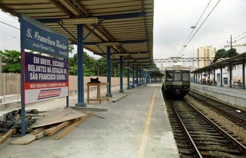
In 1906 (Revista da Semana)……and in 2006 (Photo: Ignacio Ferreira, in estacoesferroviarias.com.br)
Ein seltener Fall: dieser Bahnhof im Stadtgebiet von Rio de Janeiro ist heute, 160 Jahre später, noch im Betrieb. Er wurde 1861 durch die E.F. Dom Pedro II Bahngesellschaft eingeweiht und lag als fünfte Haltestelle nach dem Hauptbahnhof an der Abzweigung nach Petropolis. Nach dem Ende des Kaiserreichs wurde die Bahnlinie zu E.F. Central do Brasil umbenannt, 1975 zur Rede Ferroviária Federal S.A. und seit 1997 heißt der Bahnbetreiber SuperVia (estacoesferroviarias.com.br).
Wie Nova Monteiro (Administrações e Agencias Postaes do Brasil Imperio, in Brasil Filatelico/RJ, 1934-5; Reprint SPP 1994-1999) berichtet, wurde das Bahnhofspostamt im Juli 1864 ins Leben gerufen, Paulo Novaes (agenciaspostais.com.br) gibt hierfür den August 1864 an. Nur ein Poststempel wurde gefunden, wohl nicht der älteste. SMN-2185b (Samml. José A. Junges) hat einen Doppelkreis mit den Inschriften S. FRAN.co XAVIER oben und (EST.) unten. Die zwei vorhandenen Exemplare haben Daten aus 1887 und 1889 in der Mitte.
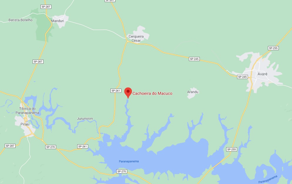
Macuco (Tinamus solitarius, Vieillot, 1819) is the solitary tinamou, a shy family member of the South American paleognath ground birds. After him, a creek was named in the province of São Paulo, the Ribeirão do Macuco, a tributary of the mighty Rio Paranapanema. In the 19th century, a hamlet with a chapel dedicated to St. Francis was created on the western bank of the Ribeirão, in the municipality of Rio Novo, over 300 km west of the provincial capital. The Portuguese word salto means both jump and waterfall. So this is not about bird jumps, but rather about a beautiful waterfall, which can still be admired today:
Photo: Fabricio Bachiega
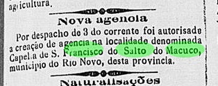
The place itself has not progressed, it has not become either a freguesia or a district. Today it is only a rural suburb of the town of Cerqueira César. Nobody knows why a post office was built there in March 1888:
Correio Paulistano, March 7, 1888
However, it is known that this beautiful place was located on the mail route between Avaré and Pirajú. Through the post office, the courier could stay there a little longer. But not for a long time: by 1900 the post office was already closed, probably due to lack of demand. A place stamp could be found: SSP-1805a (Coll. Mário Orsi Jr.) has a double circle with the inscriptions S. FRANCISCO DO SALTO DO MACUCO above and S. PAULO below. Both existing copies have dates of 1898 at the centre.
Google Maps
Der Macuco (Tinamus solitarius, Vieillot, 1819) ist der Grausteißtinamu, ein scheuer Vogel der Familie der Steißhühner, der in Südamerika zu Hause ist. Nach ihm wurde ein Bach in der Provinz São Paulo genannt, der Ribeirão do Macuco, ein Zufluss des mächtigen Rio Paranapanema. Am Westufer des Ribeirão entstand im 19. Jahnhundert ein Weiler mit einer dem Hl. Franz gewidmeten Kapelle, im Município von Rio Novo, über 300 km westlich der Provinzhauptstadt gelegen. Das portugiesische Wort Salto bedeutet sowohl Sprung als auch Wasserfall. Hier geht es also nicht um Vogelsprünge, sondern um einen schönen Wasserfall, den man heute noch bewundern kann:
Foto: Fabricio Bachiega
Der Ort selber ist nicht vorangekommen, er wurde weder eine Freguesia noch ein Distrikt. Heute ist er lediglich ein ländlicher Vorort des Städtchens Cerqueira César. Niemand weiß, warum dort ein Postamt im März 1888 errichtet wurde:
Correio Paulistano, 7. März 1888
Man weiß aber, dass dieser schöne Ort auf der Poststafettenstrecke zwischen Avaré und Pirajú lag. Durch das Postamt konnte die Stafette doch etwas länger dort bleiben. Aber nicht mehr lange: um 1900 war das Postamt bereits geschlossen, wohl aus Mangel an Nachfrage. Ein Ortsstempel konnte doch gefunden werden: SSP-1805a (Samml. Mário Orsi Jr.) hat einen Doppelkreis mit den Inschriften S. FRANCISCO DO SALTO DO MACUCO oben und S. PAULO unten. Beide vorhandenen Exemplare haben ein Datum vom Jahr 1898 in der Mitte.
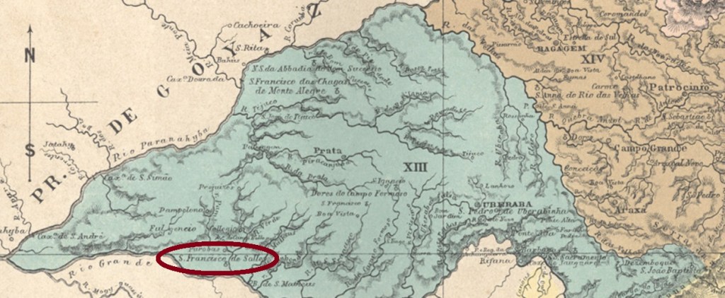
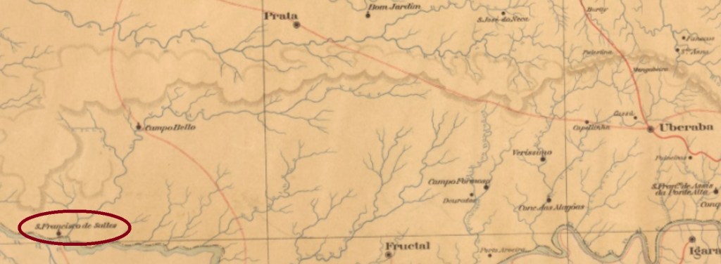
São Francisco de Salles was from May 1850 on a district of Fructal, located on the north bank of the Rio Grande, more than 800 km west of the provincial capital Ouro Preto. In December 1938, the town changed as a district of the municipality of Campina Verde and received its political emancipation in December 1962.
The local post office was established in February 1882, as Paula Sobrinho writes in Historia Postal de Minas Gerais (Belo Horizonte, 1997). The only known cancel from the imperial era is SMG-2280a (image from the internet): a double circle with the inscription S. FRANCISCO DE SALLES above and a diamond ornament at the bottom, which consists of four small diamonds. The dates at the centre date back to the period 1888-1898.
Mappa de Minas Geraes, 1910
São Francisco de Salles war ab Mai 1850 ein Distrikt von Fructal, der am Nordufer des Rio Grande, über 800 km westlich der Provinzhauptstadt Ouro Preto entfernt lag. Im Dezember 1938 wechselte der Ort als Distrikt des Município von Campina Verde und erhielt seine politische Emanzipation im Dezember 1962.
Das örtliche Postamt entstand im Februar 1882, wie Paula Sobrinho in História Postal de Minas Gerais (Belo Horizonte, 1997) schreibt. Der einzig bekannte Stempel aus der Kaiserzeit ist SMG-2280a (Abb. aus dem Internet): Ein Doppelkreis mit der Inschrift S. FRANCISCO DE SALLES oben und einem Rautenornament unten, das aus vier kleinen Rauten besteht. Die Daten in der Mitte entstammen dem Zeitraum 1888-1898.
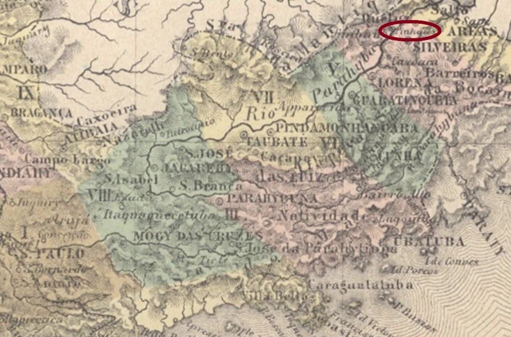
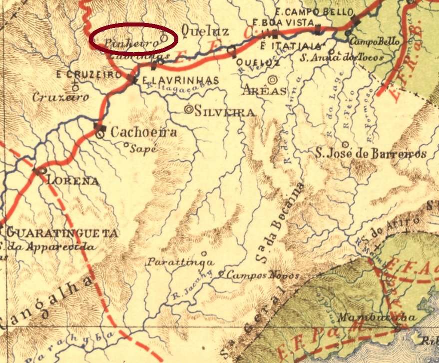
See also Pinheiros/SP (R. Koester: Carimbologia XXXI)
São Francisco de Paula dos Pinheiros was from March 1846 on a freguesia located in the municipality of Queluz, about 230 km northeast of the provincial capital of São Paulo. The village arose twice to a municipality, in December 1917 and in September 1937. It then descended twice to a district: in May 1934 and in November 1944, most recently in the municipality of Lavrinhas. Time seems to have stopped here: in 1880 there were more than 2.7 thousand people living there, in 2010 there were just 2,000 inhabitants on place.
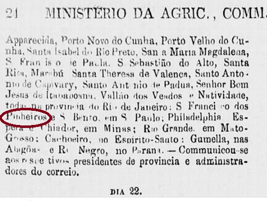
This ups and downs were reflected in the postal system. Nova Monteiro (Administrações e Agencias Postaes do Brasil Imperio, in Brasil Filatelico/RJ, 1934-5; Reprint SPP 1994-1999) reports a post office creation in September 1860. But as early as June 1861, the locality was on a list of deleted postal agencies:
Expediente do Ministério do Império, 21 June 1861
It took a while until the reopening, because it was not until November 1867 that Pinheiros reappeared in reports about postal routes. No cancel of the imperial period has been found yet under this name. For postmarks with Pinheiros/SP, see Koesters Carimbologia XXXI.
Estrada de Ferro Central do Brasil, 1890
Buchtext-Aktualisierung vom 23. Februar 2021
Siehe auch Pinheiros/SP (R. Koester: Carimbologia XXXI)
São Francisco de Paula dos Pinheiros war ab März 1846 eine Freguesia im Município von Queluz, ca. 230 km nordöstlich der Provinzhauptstadt São Paulo gelegen. Der Ort stieg zweimal zum Município auf, im Dezember 1917 und im September 1937. Und stieg anschließend zweimal zum Distrikt ab: im Mai 1934 und im November 1944, zuletzt im Município von Lavrinhas. Hier scheint die Zeit stehen geblieben zu sein: 1880 lebten dort über 2,7 tausend Menschen, im Jahre 2010 waren gerade 2.000 Einwohner dort gemeldet.
Dieses Auf und Ab spiegelte sich im Postwesen wider. Nova Monteiro (Administrações e Agencias Postaes do Brasil Imperio, in Brasil Filatelico/RJ, 1934-5; Reprint SPP 1994-1999) berichtet, das dortige Postamt eröffnete im September 1860. Aber bereits im Juni 1861 stand dieser Ort auf einer Liste von gelöschten Postagenturen:
Expediente do Ministério do Império, 21. Juni 1861
Es dauerte noch eine Weile bis zur Neueröffnung, denn erst im November 1867 erschien Pinheiros in Meldungen über Postrouten wieder. Kein Stempel der Kaiserzeit wurde bisher unter diesem Namen gefunden. Für Stempel mit Pinheiros/SP siehe Koesters Carimbologia XXXI.
Other names: Jacareguai, São Francisco de Oliveira, Wenceslau Braz
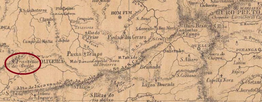
From December 1867 on, this São Francisco de Paula from the province of Minas Gerais was a freguesia of Oliveira, which was located more than 200 km west of the capital Ouro Preto. In September 1923, the place name changed to Jacareguai. This name is an Indian-looking merge of crocodile (yacaré) and human (guai) and did not please the population at all. A year later, the town was called S. Francisco de Oliveira, and in December 1962 the political emancipation came under the name of Município of Wenceslau Braz, in memory of the former president of Brazil (1868-1966). However, given that in 1964 another municipality with the same name was created in Minas Gerais, the original name of S. Francisco de Paula returned definitively in June 1976.
According to Paula Sobrinho (História Postal de Minas Gerais, Belo Horizonte, 1997), there has been a post office there since December 1879. Unfortunately, there is a single copy of the only cancel in the Empire so far, which shows only its right half. SMG-2275a (Coll. Dieter Kerkhoff) appears in purple in an edition of 1885 and consists of a double circle with the inscriptions (…) E PAULA above and (…) LIVEIRA below. Date at the centre.
Provincia de Minas Geraes, 1873
Andere Namen: Jacareguai, São Francisco de Oliveira, Wenceslau Braz
Dieser São Francisco de Paula aus der Provinz Minas Gerais war ab Dezember 1867 eine Freguesia von Oliveira, die über 200 km westlich von der Hauptstadt Ouro Preto entfernt lag. Im September 1923 wechselte der Ortsname zu Jacareguai. Dieser Name ist eine indianisch anmutende Erfindung aus Krokodil (yacaré) und Mensch (guai) und kam überhaupt nicht bei der Bevölkerung an. Ein Jahr später hieß der Ort São Francisco de Oliveira, und im Dezember 1962 kam die politische Emanzipation, unter dem Namen Município von Wenceslau Braz, in Erinnerung an den ehemaligen Präsidenten Brasiliens (1868-1966). Da aber 1964 ein weiterer Município mit gleichem Name in Minas Gerais entstanden ist, kehrte der ursprüngliche Name São Francisco de Paula im Juni 1976 definitiv zurück.
Laut Paula Sobrinho (História Postal de Minas Gerais, Belo Horizonte, 1997), gibt es dort ein Postamt seit Dezember 1879. Vom bisher einzigen Stempel im Kaiserreich gibt es leider nur ein Exemplar, das obendrein nur seine rechte Hälfte zeigt. SMG-2275a (Samml. Dieter Kerkhoff) kommt in violett in einer Ausgabe von 1885 vor und besteht aus einem Doppelkreis mit den Inschriften (…)E PAULA oben und (…)LIVEIRA unten. Datum in der Mitte.
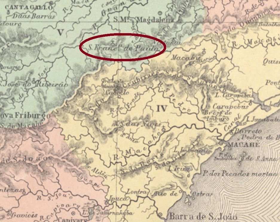
Other names: S. Francisco de Paula, Trajano de Morais (1938)
This place became a freguesia in the municipality of Cantagallo (= Crowing Cock) in May 1856 and was located about 250 km northeast of the imperial capital Rio de Janeiro. In October 1861 it switched as a district to Santa Maria Magdalena and ascended in May 1891 to a villa in own municipality. Since March 1938, the place is called Trajano de Morais. This was the name of an important landowner of noble family in the region, who died in 1911.
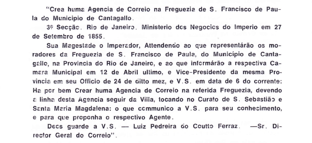
As Nova Monteiro writes in Administrações e Agencias Postaes do Brasil Imperio (Brasil Filatelico/RJ, 1934-5; Reprint SPP 1994-1999), the local post office was established in October 1855. This is confirmed by Aureo G. Santos in Agencias de Correio Criadas e Suprimidas 1851, 1855, 1856 e 1857 (Brasil Filatélico 181, Rio de Janeiro, 1977):
Aureo G. Santos (op. cit.)
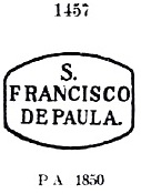
The first postmark, SRJ-0930a, is also available in blue; it circulated until at least 1866 and was already presented by Paulo Ayres (Catalogo de Carimbos Brasil-Império, S. Paulo, 1937, 1942) under No. 1457:
SRJ-0930a (P.A. 1457)
Three cancels with double circles followed. At SRJ-0930b (agenciaspostais.com.br) we have the inscription S.F. DE PAULA above and an (I) below. Dates at the centre: 1877-1888. The upper inscription in SRJ-0930c (agenciaspostais.com.br) is S. Fco. DE PAULA DE CANTAGALLO, below there is an oval ornament, which consists of four small triangles, and has a diamond space in its centre. Dates: ca.1884-1893. SRJ-0930d (Coll. Dieter Kerkhoff) could already be Republican, for its dates at the centre cover the period 1894-1897. Here is the inscription S. FRANco. DE PAULA DE CANTAGALLO above, with a cross-shaped ornament at the bottom.
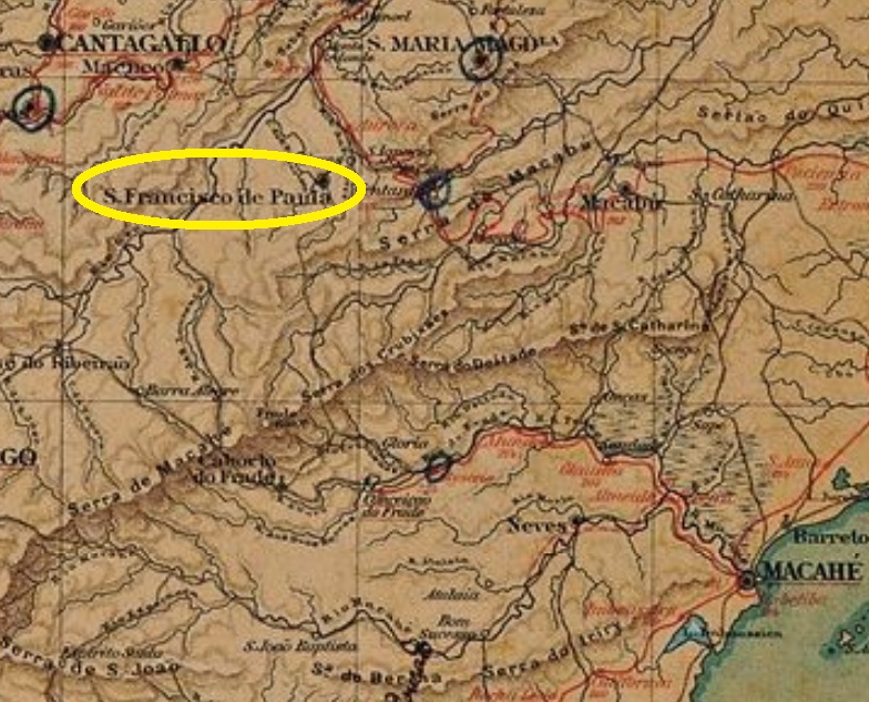
Almanak Laemmert, 1892
Andere Namen: S. Francisco de Paula, Trajano de Morais (1938)
Dieser Ort wurde im Mai 1856 zur Freguesia im Município von Cantagallo (= Krähender Hahn) und lag ca. 250 km nordöstlich der kaiserlichen Hauptstadt Rio de Janeiro. Im Oktober 1861 stieg er zum Distrikt und, im Mai1891, zur Villa im eigenem Município. Seit März 1938 gilt der Ortsname Trajano de Morais. So hieß ein Großgrundbesitzer aus einer Adelsfamilie der Region, der 1911 starb.
Es folgten drei Stempel mit Doppelkreisen. Bei SRJ-0930b (agenciaspostais.com.br) haben wir die Inschrift S.F. DE PAULA oben und einem (I) unten. Die Daten in der Mitte: 1877-1888. Die obere Inschrift in SRJ-0930c (agenciaspostais.com.br) lautet S. Fco. DE PAULA DE CANTAGALLO, unten gibt es ein Ornament im Oval, das aus vier kleinen Dreiecken besteht und einen Leerraum in Rautenform in seiner Mitte hat. Daten: ca.1884-1893. SRJ-0930d (Samml. Dieter Kerkhoff) könnte bereits republikanisch sein, da seine Daten in der Mitte den Zeitraum 1894-1897 umfassen. Hier lautet die Inschrift S. FRANco. DE PAULA DE CANTAGALLO oben, mit einem kreuzförmigen Ornament unten.