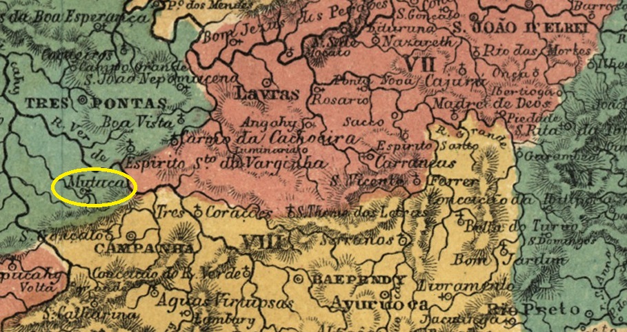
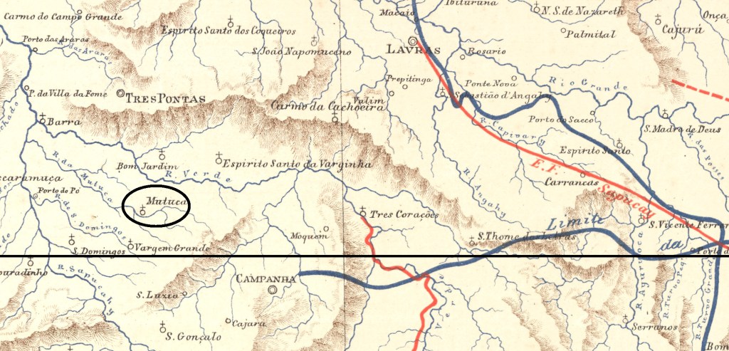
The Freguesia de Espírito Santo da Mutuca existed since May 1856. It belonged to the Vila de Campanha and was located on the north bank of the Ribeirão da Mutuca, 370 kilometres southwest of the provincial capital Ouro Preto. The name ‘Mutuca’ (also ‘Botuca’) is of Indian origin and is used in Brazil for many species of horseflies of the Tabanidae family.
Chrysops relictus (photo: pudding4brains).
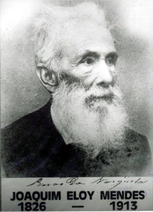
In September 1890, the village was renamed Pontal and has since belonged to the Municipality of Varginha. Since August 1911, it has been the Município de Elói Mendes. Elói Mendes was a major (1826–1913) who was born in Mutuca and was ennobled as Barão de Varginha.
Eloi Mendes
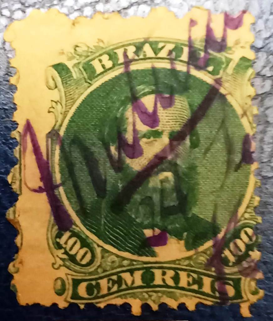
Two dates of origin have been found for the local post office. R. Koester writes in Carimbologia XXVII that it was September 1877, which is confirmed by the postal report (Relatorio Postal) for the year 1886. Paula Sobrinho, on the other hand, notes April 1877 in ‘História Postal de Minas Gerais’, Belo Horizonte, 1997.
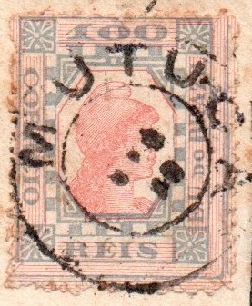
The imperial postmark is MMG-1680a (illustration by Felipe Piccinini).
MMG-1680a (FP) 1877 ff.–1893
However, there is a handwritten cancellation from the Fuad Ferreira Fo. collection that appears to date from 1876 and thus predates the official opening of the post office.
1876? (FF)Estrada de Ferro Central do Brasil, 1890
Outros nomes: Pontal, Elói Mendes (1911)
A Freguesia de Espírito Santo da Mutuca existia desde maio de 1856. Pertencia à Vila de Campanha e ficava na margem norte do Ribeirão da Mutuca, 370 quilômetros a sudoeste da capital provincial, Ouro Preto. O nome “Mutuca” (também “Botuca”) é de origem indígena e é usado no Brasil para designar muitas espécies de insetos da família Tabanidae.
Chrysops relictus (Foto: pudding4brains).
Em setembro de 1890, a localidade foi renomeada para Pontal e, desde então, pertence ao Município de Varginha. Desde agosto de 1911, ela é o município de Elói Mendes. Este foi um major (1826-1913) que nasceu em Mutuca e foi o primeiro e único Barão de Varginha.
Eloi Mendes
Foram encontradas duas datas de criação para a agência dos correios local. R. Koester escreve em Carimbologia XXVII setembro de 1877, o que é confirmado pelo Relatório Postal de 1886. Paula Sobrinho, por outro lado, anota em “História Postal de Minas Gerais”, Belo Horizonte, 1997, abril de 1877.
O carimbo postal imperial é MMG-1680a (ilustração de Felipe Piccinini).
MMG-1680a (FP) 1877 ff.–1893.
No entanto, há uma obliteração manuscrita da coleção Fuad Ferreira Fo., que aparentemente data de 1876 e, portanto, seria anterior à inauguração oficial da agência postal.
1876? (FF)Provincia de Minas Geraes, 1873
Andere Namen: Pontal, Elói Mendes (1911)
Die Freguesia de Espírito Santo da Mutuca bestand seit Mai 1856. Sie gehörte zur Vila de Campanha und lag am Nordufer des Ribeirão da Mutuca (Bremsenbach), 370 Kilometer südwestlich der Provinzhauptstadt Ouro Preto. Der Name „Mutuca” (auch „Botuca”) ist indianischen Ursprungs und wird in Brasilien für viele Bremsenarten der Familie Tabanidae verwendet.
Chrysops relictus (Foto: pudding4brains).
Im September 1890 wurde die Ortschaft in Pontal umbenannt und gehört seitdem zum Município de Varginha. Seit August 1911 ist sie der Município de Elói Mendes. Dieser war ein Major (1826–1913), der in Mutuca geboren wurde und zum Barão de Varginha geadelt wurde.
Eloi Mendes
Es wurden zwei Entstehungsdaten für das örtliche Postamt gefunden. R. Koester schreibt in Carimbologia XXVII den September 1877, was durch den Postbericht (Relatorio Postal) für das Jahr 1886 bestätigt wird. Paula Sobrinho notiert in „História Postal de Minas Gerais”, Belo Horizonte, 1997 dagegen den April 1877.
Der kaiserliche Poststempel ist MMG-1680a (Abbildung von Felipe Piccinini).
MMG-1680a (FP) 1877 ff.–1893.
Allerdings gibt es eine handschriftliche Entwertung aus der Sammlung Fuad Ferreira Fo., die scheinbar aus dem Jahr 1876 stammt und somit vor der offiziellen Poststelleneröffnung erfolgte.
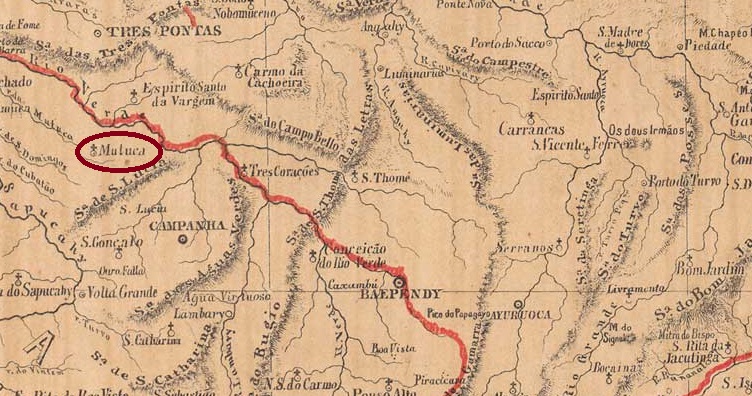
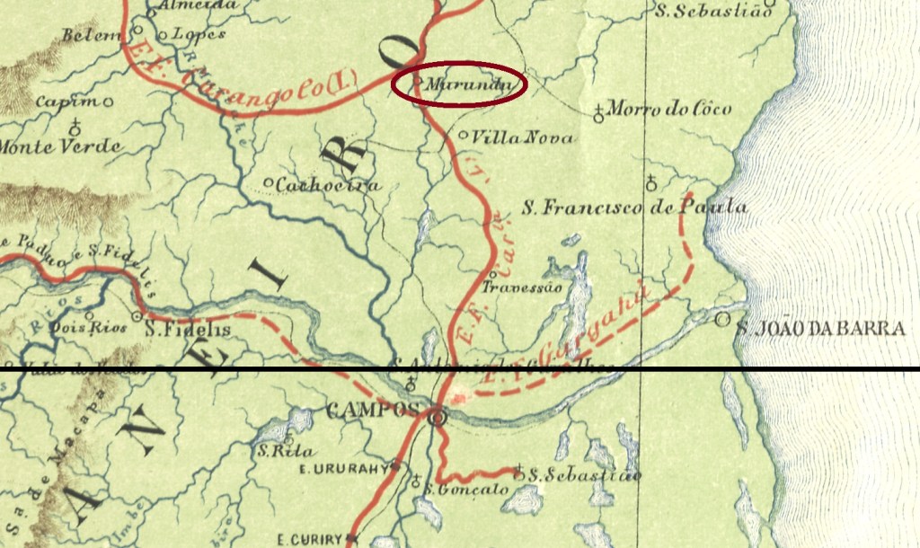
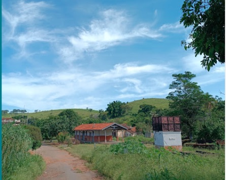
Murundú railway station was opened in August 1878 by the railway company E.F. Campos e Carangola (Coastal Line). It was in the municipality of Campos, 330 kilometres northeast of the capital Rio de Janeiro. The railway line was transferred to E.F. Leopoldina in 1890 and belonged to Rede Ferroviária Federal S.A. from 1975 until it was decommissioned in 1996 (source: estacoesferroviarias.com.br). Today, the tracks are still in place and the station building is used as accommodation for FCA freight railway employees.
In February 2023 (photo: Allan Dana, on Google Maps)
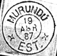
According to the directory of imperial post offices (Tabella das Agencias do Correio do Imperio, Rio de Janeiro, 1885), there has been a post office at the station since 1880. The oldest postmark to date is MRJ-2435a (fig. R. Koester in Carimbologia XXVII)
MRJ-2435a (RK) 1880ff
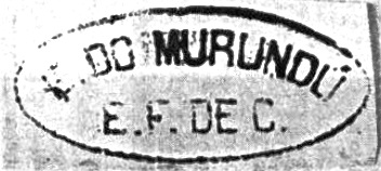
This was followed by the double circle MRJ-2435b (fig. Koester, op. cit.):
MRJ-2435b (RK) 1887Almanak Laemmert, 1892
A estação ferroviária de Murundú foi inaugurada em agosto de 1878 pela E.F. Campos e Carangola (Linha do Litoral). Localizava-se no município de Campos, 330 quilômetros a nordeste da capital Rio de Janeiro. A linha ferroviária passou para a E.F. Leopoldina em 1890 e pertenceu à Rede Ferroviária Federal S.A. de 1975 até ao seu encerramento em 1996 (fonte: estacoesferroviarias.com.br). Hoje, os trilhos ainda existem e o edifício da estação é usado como alojamento para os funcionários da ferrovia de carga FCA.
Em fevereiro de 2023 (Foto: Allan Dana, no Google Maps)
Conforme consta na Tabella das Agencias do Correio do Império (Rio de Janeiro, 1885), havia uma agência dos correios na estação desde 1880. O carimbo postal mais antigo até agora é o MRJ-2435a (fig. R. Koester em Carimbologia XXVII)
MRJ-2435a (RK) 1880ff
Seguiu-se o círculo duplo MRJ-2435b (fig. Koester, op. cit.):
MRJ-2435b (RK) 1887André S. Carvalho: Estrada de Ferro Leopoldina, 1940
Der Bahnhof Murundú wurde im August 1878 von der Eisenbahngesellschaft E.F. Campos e Carangola (Küstenlinie) eröffnet. Er lag im Município de Campos, 330 Kilometer nordöstlich der Hauptstadt Rio de Janeiro. Die Bahnlinie ging 1890 an die E.F. Leopoldina über und gehörte von 1975 bis zur Stilllegung im Jahr 1996 zur Rede Ferroviária Federal S.A. (Quelle: estacoesferroviarias.com.br). Heute sind die Gleise noch vorhanden und das Bahnhofsgebäude wird als Unterkunft für die Mitarbeiter der Güterbahn FCA genutzt.
Im Februar 2023 (Foto: Allan Dana, auf Google Maps)
Wie aus dem Verzeichnis der kaiserlichen Postämter (Tabella das Agencias do Correio do Imperio, Rio de Janeiro, 1885) hervorgeht, gab es am Bahnhof ein Postamt seit 1880. Der bisher älteste Poststempel ist MRJ-2435a (Abb. R. Koester in Carimbologia XXVII)
MRJ-2435a (RK) 1880ff
Es folgte der Doppelkreis MRJ-2435b (Abb. Koester, op. cit.):
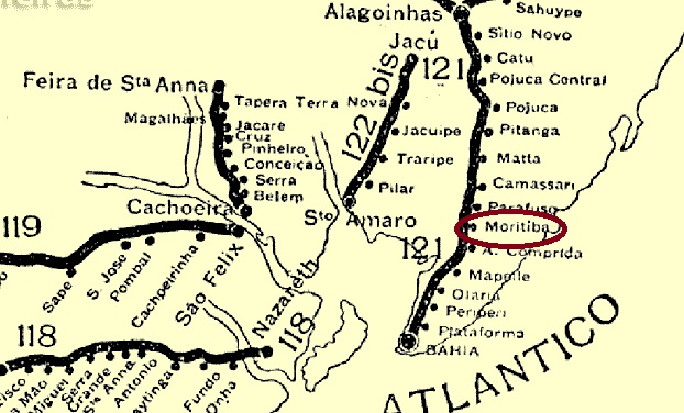
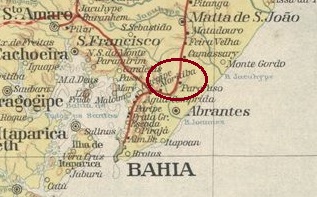
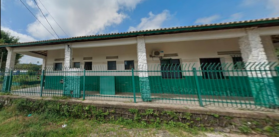
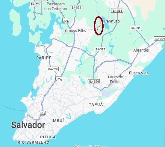
Muritiba station was opened in September 1860 by the railway company E.F. da Bahia ao S. Francisco (main line). It was in the municipality of Salvador, 35 kilometres north of the provincial capital Salvador da Bahia. The railway line was transferred to Cie. Chemins de Fer Fédéraux de l’Est Brésilien in 1911, to V.F.F. Leste Brasileiro in 1935, and belonged to Rede Ferroviária Federal S.A. from 1975 until its closure in 1996 (estacoesferroviarias.com.br). Most recently, the station building served as the community’s medical centre. In the 1930s, the station was renamed Goes Calmon (1874–1932) in memory of a former governor of the state of Bahia.
(Google Street View, July 2021)
The area around the station was incorporated into the newly founded Distrito de Água Comprida in December 1953 and has been part of the Município de Simões Filho since November 1961.
According to the 1889 Boletim Postal (Postal Bulletin), there has been a post office at the station since July 1889. However, no imperial postmark from this station has been sighted to date.
Estado da Bahia, 1913
Outros nomes: Moritiba, Muriqueira, Goes Calmon
A estação ferroviária de Muritiba foi inaugurada em setembro de 1860 pela E.F. da Bahia ao S. Francisco (Linha Tronco). Localizava-se no município de Salvador, 35 quilômetros ao norte da capital provincial Salvador da Bahia. A linha ferroviária passou para a Cie. Chemins de Fer Fédéraux de l’Est Brésilien em 1911, para a V.F.F. Leste Brasileiro em 1935 e pertenceu à Rede Ferroviária Federal S.A. (estacoesferroviarias.com.br) de 1975 até ao seu encerramento em 1996. Mais recentemente, o prédio da estação serviu para o serviço médico da comunidade. Na década de 1930, a estação foi renomeada para Goes Calmon (1874-1932), em homenagem a um antigo governador do estado da Bahia.
(Google Street View, julho de 2021)
A área ao redor da estação foi anexada ao recém-criado Distrito de Água Comprida em dezembro de 1953 e, desde novembro de 1961, faz parte do Município de Simões Filho.
Conforme consta no Boletim Postal de 1889, havia uma agência dos correios na estação desde julho daquele ano. Até o momento, porém, nenhum carimbo postal imperial dessa estação foi encontrado.
Google Maps
Andere Namen: Moritiba, Muriqueira, Goes Calmon
Der Bahnhof Muritiba wurde im September 1860 von der Eisenbahngesellschaft E.F. da Bahia ao S. Francisco (Hauptlinie) eröffnet. Er lag im Município de Salvador, 35 Kilometer nördlich der Provinzhauptstadt Salvador da Bahia. Die Bahnlinie wechselte 1911 zur Cie. Chemins de Fer Fédéraux de l’Est Brésilien, 1935 zur V.F.F. Leste Brasileiro und gehörte von 1975 bis zur Stilllegung im Jahr 1996 zur Rede Ferroviária Federal S.A. (estacoesferroviarias.com.br). Zuletzt diente das Bahnhofsgebäude dem ärztlichen Dienst der Gemeinde. In den 1930er Jahren wurde der Bahnhof in Goes Calmon (1874–1932) umbenannt, um an einen Gouverneur des Staates Bahia zu erinnern.
Google Street View, Juli 2021
Das Areal um den Bahnhof wurde im Dezember 1953 dem neu gegründeten Distrito de Água Comprida angegliedert und befindet sich seit November 1961 im Município de Simões Filho.
Wie aus dem Postbulletin (Boletim Postal) des Jahres 1889 hervorgeht, gab es am Bahnhof seit Juli 1889 ein Postamt. Bisher wurde jedoch kein kaiserlicher Poststempel aus diesem Bahnhof gesichtet.
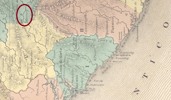
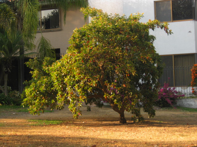
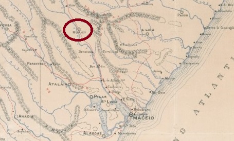
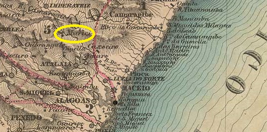
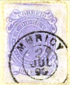
The Freguesia de Santa Teresa de Muricy existed since July 1861 and belonged to the Vila de Imperatriz. It was located on the east bank of the Mundaú, 55 km northwest of the provincial capital Maceió. In March 1872, it became a Vila and in May 1892 a town. Murici (as it is spelled today) is a tree of the Malpigiaceae family that bears cherry-sized fruits.
Byrsonima crassifolia (Photo: Von Tirrhum, CC BY 2.0)
As Aldo Cardoso writes in Contribuição para a História dos Correios de Alagoas (Maceió, 1969), there had been a post office there since July 1869. The imperial postmark is MAL-0125b (image from the internet):
MAL-0125b (EB) 1879-1890Carta Corographica do Estado de Alagoas, 1893
A Freguesia de Santa Teresa de Muricy existia desde julho de 1861 e pertencia à Vila de Imperatriz. Situava-se na margem leste do rio Mundaú, 55 km a noroeste da capital do estado, Maceió. Em março de 1872, tornou-se vila e, em maio de 1892, cidade. Murici (como se escreve hoje) é uma árvore da família Malpigiaceae, que dá frutos do tamanho de cerejas.
Byrsonima crassifolia (Foto: Von Tirrhum, CC BY 2.0)
Como escreve Aldo Cardoso em Contribuição para a História dos Correios de Alagoas (Maceió, 1969), havia uma agência dos correios no local desde julho de 1869. O carimbo postal imperial é MAL-0125b (fig. da Internet):
MAL-0125b (EB) 1879-1890Villiers de l’Ile Adam: Carta (…) das Provincias de Pernambuco, Alagoas e Sergipe, 1848
Die Freguesia de Santa Teresa de Muricy bestand seit Juli 1861 und gehörte zur Vila de Imperatriz. Sie lag am Ostufer des Mundaú, 55 km nordwestlich der Provinzhauptstadt Maceió. Im März 1872 wurde sie zur Vila und im Mai 1892 zur Stadt. Murici (wie man es heute schreibt) ist ein Baum der Familie Malpigiaceae, der kirschgroße Früchte trägt.
Byrsonima crassifolia (Foto: Von Tirrhum, CC BY 2.0)
Wie Aldo Cardoso in Contribuição para a História dos Correios de Alagoas, (Maceió, 1969) schreibt, gab es dort seit Juli 1869 ein Postamt. Der kaiserliche Poststempel ist MAL-0125b (Abb. aus dem Internet):
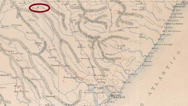
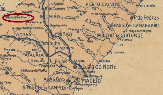
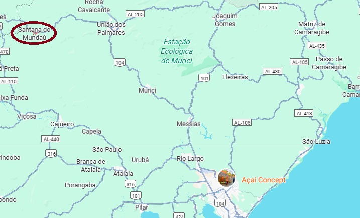
In the 19th century, this town was a district of Vila Nova da Imperatriz and was located on the south bank of the Mundaú River, 100 kilometres northwest of the provincial capital Maceió. After changes in the name of the municipality – to União in September 1890 and to União dos Palmares in December 1943 – it was elevated to the municipality of Santana do Mundaú in June 1960.
As Aldo Cardoso writes in his work ‘Contribuição para a História dos Correios de Alagoas’ (Maceió, 1969), there has been a post office there since September 1883. However, no imperial postmark from Mundaú-Merim in the province of Alagoas has been sighted to date.
Arthur D. Ribeiro: Estado de Alagoas, 1923
Outros nomes: Mundahu Meirim, Santana do Mundaú
No século XIX, esta localidade era um distrito de Vila Nova da Imperatriz e ficava na margem sul do rio Mundaú, 100 quilômetros a noroeste da capital do estado, Maceió. Após as mudanças no nome do município – em setembro de 1890 para União e em dezembro de 1943 para União dos Palmares –, ele foi elevado a município de Santana do Mundaú em junho de 1960.
Como escreve Aldo Cardoso em sua obra “Contribuição para a História dos Correios de Alagoas” (Maceió, 1969), havia uma agência dos correios no local desde setembro de 1883. Até o momento, porém, não vimos nenhum carimbo postal imperial de Mundaú-Merim, na província de Alagoas.
Google Maps
Andere Namen: Mundahu Meirim, Santana do Mundaú
Diese Ortschaft war im 19. Jahrhundert ein Distrikt der Vila Nova da Imperatriz und lag am Südufer des Mundaú, 100 Kilometer nordwestlich der Provinzhauptstadt Maceió. Nach den Wechseln im Ortsnamen des Municípios – September 1890 zu União und Dezember 1943 zu União dos Palmares – wurde er im Juni 1960 zum Município de Santana do Mundaú erhoben.
Wie Aldo Cardoso in seinem Werk „Contribuição para a História dos Correios de Alagoas” (Maceió, 1969) schreibt, gab es dort seit September 1883 ein Postamt. Bisher wurde jedoch kein kaiserlicher Poststempel aus Mundaú-Merim in der Provinz Alagoas gesichtet.
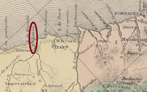
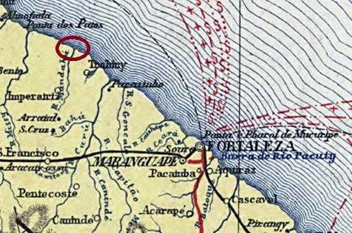
The town is idyllically located at the mouth of the Mundaú River where it flows into the Atlantic Ocean, 150 kilometres northwest of the capital Fortaleza. Until 1861, it was a district of Fortaleza. After that, its administrative jurisdiction changed several times: in November 1863, it became part of Vila de Paracuru, in August 1874 it belonged to Nossa Senhora do Livramento, which was renamed Trairi in August 1875. In August 1884, it became part of Vila de São Bento da Amontada. At the beginning of the republic, it returned to Trairi. In May 1931, it became part of the Municipality of Paracuru, in August 1935 part of the Municipality of São Gonçalo, in December 1943 part of the Municipality of Anacetaba, and in November 1951 it returned to Trairi once again. In November 1963, Mundaú became an independent município de Mundaú, but this status was revoked in December 1965 and Mundaú returned to Trairi as a district.
Nova Monteiro writes in ‘Administrações e Agencias Postaes do Brasil Imperio’ (Brasil Filatelico/RJ, 1934–1935; reprinted by SPP 1994–1999) that there had been a post office there since June 1860. However, the agency is not listed in the postal guide (Guia Postal do Império, Rio de Janeiro, 1880), which means that it must have been closed by 1879 at the latest.
No imperial postmark from Mundahú has been found to date.
Carta da Republica dos Estados Unidos do Brazil, 1892
Outra grafia: Mundaú
A localidade está situada em um local idílico, na foz do rio Mundaú, no Atlântico, 150 quilômetros a noroeste da capital Fortaleza. Até 1861, era um distrito de Fortaleza. Depois disso, mudou várias vezes de jurisdição administrativa: em novembro de 1863, passou a fazer parte da Vila de Paracuru; em agosto de 1874, pertenceu a Nossa Senhora do Livramento, que a partir de agosto de 1875 passou a se chamar Trairi. Em agosto de 1884, passou a fazer parte da Vila de São Bento da Amontada. No início da República, voltou para Trairi. Em maio de 1931, passou a fazer parte do Município de Paracuru, em agosto de 1935, do Município de São Gonçalo, em dezembro de 1943, do Município de Anacetaba e, em novembro de 1951, voltou novamente para Trairi. Em novembro de 1963, Mundaú tornou-se um município independente, o Município de Mundaú, mas esse status foi revogado em dezembro de 1965 e Mundaú voltou a ser um distrito de Trairi.
Nova Monteiro escreve em “Administrações e Agencias Postaes do Brasil Imperio” (Brasil Filatelico/RJ, 1934–1935; reimpressão SPP 1994–1999) que havia uma agência dos correios no local desde junho de 1860. No entanto, a agência não consta no Guia Postal do Império (Rio de Janeiro, 1880), pelo que deve ter sido fechada o mais tardar em 1879.
Até o momento, não foi encontrado nenhum carimbo postal imperial de Mundahú.
Sociedade Geologica e Mineralogica, 1910
Andere Schreibweise: Mundaú
Die Ortschaft liegt idyllisch an der Mündung des Mundaú in den Atlantik, 150 Kilometer nordwestlich der Hauptstadt Fortaleza. Bis 1861 war sie ein Distrikt von Fortaleza. Danach wechselte die Verwaltungszuständigkeit mehrfach: Im November 1863 wurde sie Teil der Vila de Paracuru, im August 1874 gehörte sie zu Nossa Senhora do Livramento, die ab August 1875 Trairi hieß. Im August 1884 wurde sie Teil der Vila de São Bento da Amontada. Zu Beginn der Republik kehrte sie zu Trairi zurück. Im Mai 1931 wurde sie Teil des Município de Paracuru, im August 1935 Teil des Município de São Gonçalo, im Dezember 1943 Teil des Município de Anacetaba und im November 1951 kehrte sie erneut zu Trairi zurück. Im November 1963 wurde Mundaú ein eigenständiger Município de Mundaú, doch dieser Status wurde im Dezember 1965 aufgehoben und Mundaú kehrte als Distrikt zurück zu Trairi.
Nova Monteiro schreibt in „Administrações e Agencias Postaes do Brasil Imperio” (Brasil Filatelico/RJ, 1934–1935; Nachdruck SPP 1994–1999), dass es dort seit Juni 1860 ein Postamt gab. Allerdings wird die Agentur nicht im Postführer (Guia Postal do Império, Rio de Janeiro, 1880) aufgeführt, weshalb sie spätestens 1879 geschlossen worden sein muss.
Bisher wurde kein kaiserlicher Poststempel aus Mundahú gefunden.
Carta Corographica da Provincia de Pernambuco, 1880
Other names: Camarazal
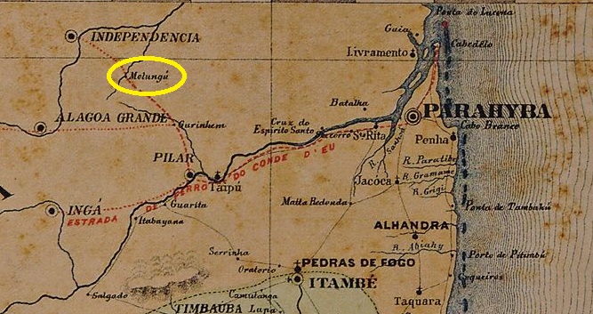
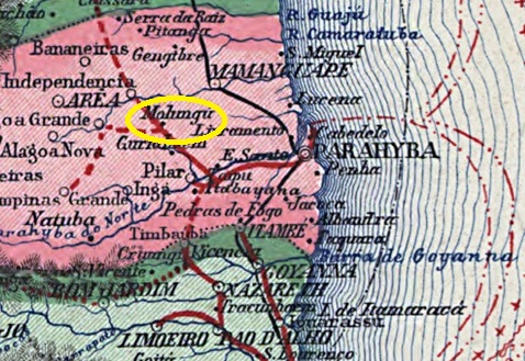
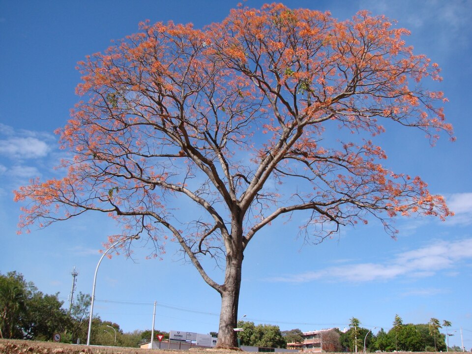
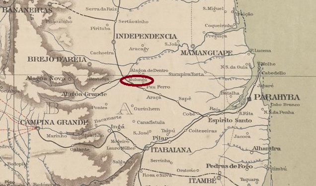
Originally, this town was the Fazenda Camarazal, located on the southern bank of the Mamanguape River, 80 kilometres west of the provincial capital Paraíba do Norte (now João Pessoa). Under the name Santo Antonio do Mulungu, it became a settlement of Vila de Guarabira in the 19th century and a district towards the end of the Empire. The place name then changed twice: in December 1943 it was changed to Camarazal and in January 1949 to Mulungu again. Mulungu has been an independent municipality since April 1959. The name refers to a tree of the Fabaceae family that is common in the region:
Erythrina mulungu (photo: João Medeiros, CC BY 2.0)
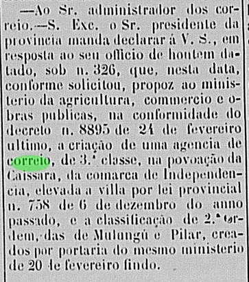
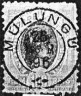
R. Koester writes in Carimbologia XXVII that there had been a post office there since February 1884. This is confirmed by the regional press:
Liberal Parahybano, 02.06.1884
The only postmark from the 19th century, MPB-0160a (fig. Koester, op. cit.), has yet to be definitively confirmed:
MPB-0160a (RK) 1887ff-1896Carta da Republica dos Estados Unidos do Brazil, 1892
Outros nomes: Camarazal
Originalmente, esta localidade era a Fazenda Camarazal, situada na margem sul do rio Mamanguape, 80 quilômetros a oeste da capital do estado, Paraíba do Norte (hoje João Pessoa). Sob o nome de Santo Antônio do Mulungu, tornou-se um povoado da Vila de Guarabira no século XIX e, no final do Império, um distrito. Depois disso, o nome da localidade mudou duas vezes: em dezembro de 1943, foi alterado para Camarazal e, em janeiro de 1949, novamente para Mulungu. Desde abril de 1959, Mulungu é um município independente. O nome designa uma árvore da família Fabaceae, comum na região:
Erythrina mulungu (Foto: João Medeiros, CC BY 2.0)
R. Koester escreve em Carimbologia XXVII que havia uma agência dos correios no local desde fevereiro de 1884. Isso é confirmado pela imprensa regional:
Liberal Parahybano, 02.06.1884
O único carimbo postal do século XIX até o momento, MPB-0160a (fig. Koester, op. cit.), ainda precisa ser confirmado definitivamente:
MPB-0160a (RK) 1887ff-1896Sociedade Geologica e Mineralogica, 1910
Andere Namen: Camarazal
Ursprünglich war diese Ortschaft die Fazenda Camarazal, die am Südufer des Mamanguape lag, 80 Kilometer westlich der Provinzhauptstadt Paraíba do Norte (heute João Pessoa). Unter dem Namen Santo Antonio do Mulungu wurde sie im 19. Jahrhundert eine Siedlung der Vila de Guarabira und gegen Ende des Kaiserreichs ein Distrito. Danach wechselte der Ortsname zweimal: Im Dezember 1943 wurde er zu Camarazal geändert und im Januar 1949 erneut zu Mulungu. Seit April 1959 ist Mulungu ein eigenständiger Município. Der Name bezeichnet ein Baum der Familie Fabaceae, der in der Region häufig vorkommt:
Erythrina mulungu (Foto: João Medeiros, CC BY 2.0)
R. Koester schreibt in Carimbologia XXVII, dass es dort seit Februar 1884 ein Postamt gab. Dies wird durch die regionale Presse bestätigt:
Liberal Parahybano, 02.06.1884
Der bisher einzige Poststempel im 19. Jahrhundert MPB-0160a (Abb. Koester, op. cit.) muss noch endgültig bestätigt werden:
Other names: Santa Clara do Mucury, Santa Clara, Aymorés, Indiana, Nanuque (1943)
See also Santa Clara (SBA-0645)
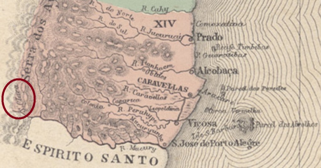
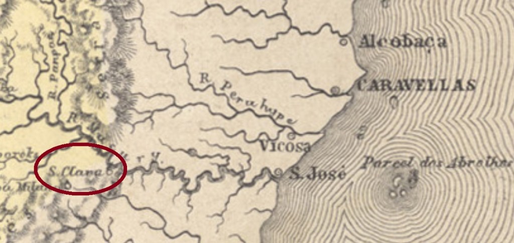
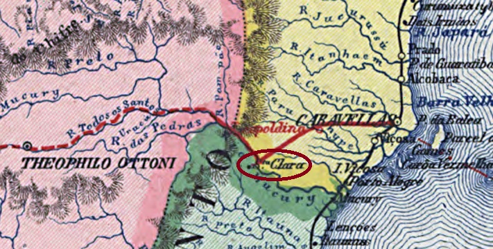
Here we have once more a fascinating story about a post office in a locality with a turbulent history. Santa Clara began as a colony of the municipality of São José de Porto Alegre (now the town of Mucuri) in the Bahia province, situated on the Mucuri River, over a thousand km south of the province capital Salvador. Since it was located near the border to two other provinces (Minas Gerais and Espírito Santo), for some strategic reason it must have been disputed among them, for it not only has caused often changes in the border lines, but also appears in different provinces on maps from the same year and author (see above).
Apparently, the origin of Santa Clara’s attractiveness was related with plans about separating the Minas Gerais province in two halves during the empire. Considering that the capital of the northern province would be Philadelphia (now: Teófilo Otoni), it is quite probable that Teophilo B. Ottoni (1807-1869) initiated and followed this goal. The influent journalist, entrepreneur and politician started many traffic projects in the region: the road between Philadelphia and Santa Clara, inaugurated in August 1857 as the first one in the Brazilian Empire, the Bahia-Minas Railway, which would link both provinces from 1881 on, and the Mucury River Navigation Company in the fifties, which intended to facilitate European immigration.
Ottoni’s premature death stopped most of those projects, but Santa Clara went to Minas Gerais as a district to the municipality of Minas Novas in November 1877, and changed in October 1881 as the freguesia of Santa Clara do Mucury to the municipality of Teophilo Ottoni. In December 1902 it became the district of Aymorés, which changed the toponym to Indiana in September 1923. In December 1938 it passed as a district to the new municipality of Carlos Chagas, and changed in December 1943 the toponym again, to Nanuque. Finally, in December 1948 Nanuque was given an own municipality.
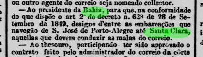
According to the Imperial Mail Register (Tabella das Agencias do Correio do Imperio) of 1885, the local post office was created in 1867, still in the Bahia province. Indeed, there were even before that time postal services along the Mucury River, as the Rio press reports:
Jornal do Commercio/RJ, December 25, 1861
Some time later, this agency must have passed to the control of Minas Gerais, because by May 1872 it returned to Bahia, as noticed by the Minas Gerais press:
O Noticiador de Minas, May 1st, 1872
It is still uncertain when it returned definitively to Minas Gerais, but since it is mentioned in the Bahia press until ca. 1880, one can assume that Santa Clara changed the province for good from then on.
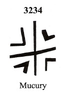
The earliest cancels were already presented by R. Koester under Mucury (Carimbologia XXVII). Initially, the stamps were cancelled by hand:
1867ff (RK)
Around this time, a mute cancel was also used, which was given the number 3824 by James Dingler and Klerman W. Lopes in Mute Cancellations of the Brazil Empire / Carimbos Mudos do Brasil Império, (Brazil Philatelic Association, Rio de Janeiro, 2000):
BPA 3824 (1867ff)
Later, the French type MMG-3875a (illustration by Claudio Coelho) also appeared:
MMG-3875a (CC) 1876ff
For later cancels (with Santa Clara) see SBA-0645.
Outros nomes: Santa Clara do Mucury, Santa Clara, Aymorés, Indiana, Nanuque (1943)
Atlas do Imperio do Brasil, 1868
Veja também Santa Clara (SBA-0645)
Aqui temos outra históra fascinante sobre uma agência postal numa localidade de história agitada. Santa Clara era originalmente uma colônia do município baiano de São José de Porto Alegre (hoje cidade e município de Mucuri), às margens do Rio Mucuri, a mais de mil km ao sul de Salvador. Estando localizada próxima à fronteira com outras duas províncias (Minas Gerais e Espírito Santo), por alguma razão estratégica foi ela cobiçada por ambas. E por isso, trocou de província algumas vezes, conseguindo mesmo aparecer, no mesmo mapa, como pertencente a províncias diversas (veja imagens acima).
Possivelmente seria a atratividade de Santa Clara relacionada a planos de separar a provínicia mineira em duas partes, durante o Segundo Império. Considerando que a capital duma eventual província do norte mineiro deveria ser Filadélfia (hoje Teófilo Otoni), é bem possível que o jornalista, empresário e político Teophilo B. Ottoni (1807-1869) estivesse por trás desses planos. Pois este empreendeu diversos projetos de transporte na região: a estrada de Philadelphia a Santa Clara, inaugurada em agosto de 1857 e considerada a primeira estrada de rodagem interurbana do Império; a ferrovia Bahia-Minas, que ligaria ambas províncias a partir de 1881; ou ainda a Companhia de Navegação do Rio Mucury, que facilitaria a introdução de imigrantes europeus na região.
A morte de Teophilo Ottoni freou ou abortou esses projetos, mas Santa Clara passou para Minas Gerais como distrito do município de Minas Novas em novembro de 1877, e mudou-se para o município de Teophilo Ottoni em outubro de 1881, como a freguesia de Santa Clara do Mucury. Em dezembro de 1902 tornou-se o distrito de Aymorés, que trocaria de topônimo para Indiana em setembro de 1923. Em dezembro de 1938 passaria a ser distrito do novo município de Carlos Chagas, e trocou de nome novamente em dezembro de 1943, para Nanuque, que finalmente virou município em dezembro de 1948.
Segundo a Tabella das Agencias do Correio do Imperio de 1885, a agência postal local foi criada em 1867, ainda na província baiana. Mas segundo a imprensa fluminense informa, já havia transporte de malas postais ao longo do rio Mucuri antes dessa data:
Jornal do Commercio, RJ, 25.12.1861
Algum tempo depois, esta agência deve ter passado ao controle de Minas Gerais, porque até maio de 1872 já tinha retornado à Bahia, como informa a imprensa mineira:
O Noticiador de Minas, 01.05.1872
Não sabemos quando Santa Clara veio em definitivo para Minas, mas como ela foi regularmente mencionada na imprensa baiana até ca. 1880, é possível que a mudança final tenha ocorrido por essa época.
Os carimbos mais antigos já foram apresentados por R. Koester sob o topônimo Mucury (Carimbologia XXVII). Inicialmente, os selos eram obliterados manualmente:
1867ff (RK)
Nessa época, também era utilizado um carimbo mudo, que recebeu o número 3824 de James Dingler e Klerman W. Lopes em Mute Cancellations of the Brazil Empire / Carimbos Mudos do Brasil Império (Clube Filatélico do Brasil, Rio de Janeiro, 2000):
BPA 3824 (1867ff)
Mais tarde, surgiu também o tipo francês MMG-3875a (fig. Claudio Coelho):
MMG-3875a (CC) 1876ff
Para carimbos posteriores (com Santa Clara), ver SBA-0645.
Carta da Republica dos Estados Unidos do Brazil, 1892
Andere Namen: Santa Clara do Mucury, Santa Clara, Aymorés, Indiana, Nanuque (1943)
Siehe auch Santa Clara (SBA-0645)
Hier haben wir wieder mit einem faszinierenden Fall eines Postamtes zu tun, dessen turbulente Geschichte viele Kapriolen schlug. Santa Clara war ursprünglich eine Kolonie im Município von São José de Porto Alegre (heute: Mucuri), die am Ufer des Mucuri über tausend km südlich der Provinzhauptstadt Salvador da Bahia entfernt lag. Da sie direkt an der Grenze zu zwei weiteren Provinzen (Minas Gerais und Espirito Santo) strategisch lag, wurde sie jahrzehntelang ein begehrtes Objekt. Santa Clara sollte mehrmals die Seite wechseln und schaffte es sogar , auf der gleichen Karte zwei unterschiedlichen Provinzen zugeordnet zu sein (siehe Abb. ganz oben).
Scheinbar hatte der Reiz Santa Claras mit alten Plänen zu tun, die kaiserliche Provinz Minas Gerais zu teilen. Da die geplante Hauptstadt der daraus entstehenden nördlichen Provinz Philadelphia (heute: Teófilo Otoni) sein sollte, ist es gut möglich, dass die Spaltungsidee aus dem Umkreis von Teophilo B. Ottoni (1807-1869) entsprang. Dieser einflussreiche Journalist, Unternehmer und Politiker initiierte mehrere Verkehrsprojekte in der Region: eine im August 1857 eingeweihte Strasse zwischen Philadelphia und Santa Clara (die erste Fernstrasse des brasilianischen Kaiserreichs), die Bahia-Minas Eisenbahngesellschaft, die die gleichnamigen Provinzen miteinander verbinden sollte, oder die Flussschifffahrtsgesellschaft Rio Mucury, die die europäische Einwanderung erleichtern sollte.
Ottonis früher Tod brachte einige der Projekte zum Erliegen, aber Santa Clara ging im November 1877 nach Minas Gerais als ein Distrikt des Município von Minas Novas und wechselte im Oktober 1881 als die Freguesia von Santa Clara do Mucury zum Município von Teophilo Ottoni. Im Dezember 1902 hieß der Distrikt Aymorés und ab September 1923 wurde er Indiana genannt. Im Dezember 1938 gehörte er zum neu gegründeten Município von Carlos Chagas und im Dezember 1943 wechselte der Ortsname abermals, zu Nanuque. Seit Dezember 1948 ist Nanuque ein eigener Município.
Laut Verzeichnis der kaiserlichen Postämter (Tabella das Agencias do Correio do Imperio) von 1885 entstand das örtliche Postamt in 1867, also noch in der Provinz Bahia. Allerdings gab es schon vorher Postverkehr entlang des Mucury, wie die Presse aus Rio berichtet:
Jornal do Commercio/RJ, 25.12.1861
Irgendwann später musste dieses Postamt Minas Geraes zugeordnet gewesen sein, denn im Mai 1872 wurde die Rückkehr in die Provinz Bahia bekannt gemacht:
O Noticiador de Minas, 01.05.1872
Es ist auch nicht bekannt, wann genau Santa Clara nach Minas Gerais definitiv zurückkehrte. Da sie in der Presse Bahias bis ca. 1880 erwähnt wird, können wir davon ausgehen, dass dieser letzte Wechsel um diese Zeit stattgefunden hat.
Die frühesten Stempel dieser Ortschaft wurden bereits durch R. Koester unter Mucury vorgestellt (Carimbologia XXVII). Zunächst wurden die Briefmarken per Hand entwertet:
1867ff (RK)
Um diese Zeit wurde auch ein stummer Stempel verwendet, der von James Dingler und Klerman W. Lopes in Mute Cancellations of the Brazil Empire / Carimbos Mudos do Brasil Império (Brazil Philatelic Association, Rio de Janeiro, 2000) die Nr. 3824 erhielt:
BPA 3824 (1867ff)
Später erschein auch der französischer Typ MMG-3875a (Abb. Claudio Coelho):
MMG-3875a (CC) 1876ff
Für spätere Stempel (mit Santa Clara) siehe SBA-0645.
Villiers de l’Ile Adam: Carta (…) das Provincias do Grão-Pará e Alto Amazonas, 1850
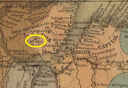
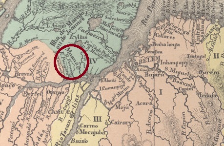
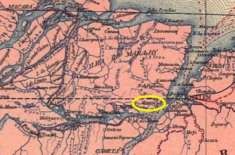
The Freguesia de S. Francisco de Paula de Muaná existed since 1757 on the west bank of the river of the same name, 80 kilometres west of the later provincial capital Belém do Pará. In May 1833, it became a vila and in July 1895 a town. The place name comes from the Tupi language and means ‘like a snake’, which is said to refer to the curves of the river.
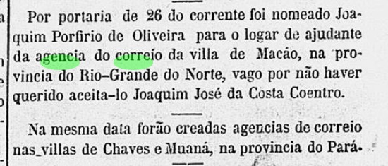
R. Koester writes in Carimbologia XXVII that there had been a post office there since March 1865. However, this is likely to be a transcription error, as Nova Monteiro gives a date from the following month in Administrações e Agencias Postaes do Brasil Imperio (Brasil Filatelico/RJ, 1934–1935; reprinted by SPP 1994–1999) gives a date from the following month. This is confirmed by the press in Rio:
Correio Mercantil/RJ, 28 April 1865
No imperial postmark from Muaná has been seen to date.
Atlas do Imperio do Brasil, 1868
A Freguesia de S. Francisco de Paula de Muaná existia desde 1757 na margem oeste do rio de mesmo nome, 80 quilômetros a oeste da futura capital provincial Belém do Pará. Em maio de 1833, tornou-se vila e, em julho de 1895, cidade. O nome do local vem da língua tupi e significa “como uma cobra”, o que se deve às curvas do rio.
R. Koester escreve em Carimbologia XXVII que havia uma agência dos correios lá desde março de 1865. No entanto, isso deve ser um erro de transcrição, pois Nova Monteiro indica em Administrações e Agências Postais do Brasil Império (Brasil Filatélico/RJ, 1934–1935; reimpressão SPP 1994–1999) uma data do mês seguinte. Isso é confirmado pela imprensa do Rio:
Correio Mercantil/RJ, 28/04/1865
Até o momento, nenhum carimbo postal imperial de Muaná foi visto.
Carta da Republica dos Estados Unidos do Brazil, 1892
Die Freguesia de S. Francisco de Paula de Muaná bestand seit 1757 am Westufer des gleichnamigen Flusses, 80 Kilometer westlich der späteren Provinzhauptstadt Belém do Pará. Im Mai 1833 wurde sie zur Vila und im Juli 1895 zur Stadt. Der Ortsname stammt aus der Tupi-Sprache und bedeutet „wie eine Schlange“, was auf die Flusskurven zurückzuführen sei.
R. Koester schreibt in Carimbologia XXVII, dass es dort seit März 1865 ein Postamt gab. Dies dürfte jedoch ein Abschreibfehler sein, denn Nova Monteiro gibt in Administrações e Agencias Postaes do Brasil Imperio (Brasil Filatelico/RJ, 1934–1935; Nachdruck SPP 1994–1999) ein Datum aus dem Folgemonat an. Dies wird durch die Presse aus Rio bestätigt:
Correio Mercantil/RJ, 28.04.1865
Bisher wurde kein kaiserlicher Poststempel aus Muaná gesehen.
Villiers de l’Ile Adam: Carta (…) das Provincias do Grão-Pará e Alto Amazonas, 1850
Other names: Itarendaua, Pedreira
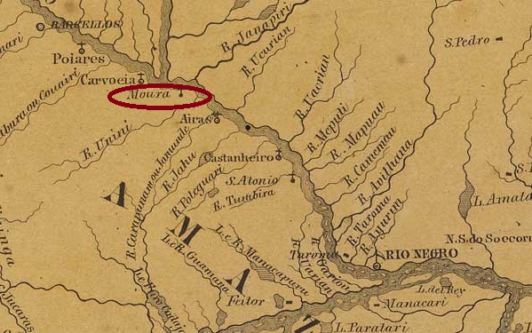
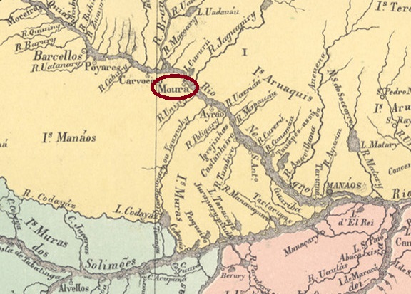
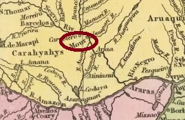
The Freguesia de Santa Rita de Cássia de Moura existed since 1758. It belonged to the Vila de Barcelos and was located on the south bank of the Rio Negro, approximately 260 km (river route) northwest of the later provincial capital Manaus. In October 1878, it was elevated to the status of Vila, but this decision was short-lived: in June 1881, it was downgraded to Freguesia in the Município de Barcelos. In December 1891, Moura became a Município again, but in September 1943, it was downgraded once more to Distrito of Barcelos. In April 1961, Moura was subordinated to the short-lived municipality of Carvoeiro and finally returned to Barcelos as a district in December 1963.
As R. Koester writes in Carimbologia XXVII, there had been a post office there since 1884. This was closed in September 1891 and reopened in January 1892. No imperial postmark from Moura has been found to date.
Atlas do Imperio do Brasil, 1868
Outros nomes: Itarendaua, Pedreira
A Freguesia de Santa Rita de Cássia de Moura existia desde 1758. Pertencia à Vila de Barcelos e ficava na margem sul do Rio Negro, a cerca de 260 km (por via fluvial) a noroeste da futura capital provincial Manaus. Em outubro de 1878, foi elevada à categoria de Vila, mas essa decisão não teve longa duração: em junho de 1881, foi rebaixada a Freguesia no Município de Barcelos. Em dezembro de 1891, Moura voltou a ser Município, mas em setembro de 1943 foi novamente rebaixada a Distrito de Barcelos. Em abril de 1961, Moura foi subordinada ao efêmero município de Carvoeiro e, em dezembro de 1963, voltou finalmente como distrito de Barcelos.
Como escreve R. Koester em Carimbologia XXVII, havia ali uma agência de correio desde 1884. Esta foi fechada em setembro de 1891 e reaberta em janeiro de 1892. Até ao momento, não foi encontrado nenhum carimbo postal imperial de Moura.
Samuel A. Mitchell: Map of the Brazil, 1854
Andere Namen: Itarendaua, Pedreira
Die Freguesia de Santa Rita de Cássia de Moura bestand seit 1758. Sie gehörte zur Vila de Barcelos und lag am Südufer des Rio Negro, ca. 260 km (Flussweg) nordwestlich der späteren Provinzhauptstadt Manaus. Im Oktober 1878 wurde sie zur Vila erhoben, doch diese Entscheidung hatte keinen Bestand: Im Juni 1881 erfolgte die Herabstufung zur Freguesia im Município de Barcelos. Im Dezember 1891 wurde Moura wieder zum Município, im September 1943 erfolgte die erneute Abstufung zum Distrito von Barcelos. Im April 1961 wurde Moura dem kurzlebigen Município de Carvoeiro untergeordnet und kam im Dezember 1963 schließlich als Distrikt zu Barcelos zurück.
Wie R. Koester in Carimbologia XXVII schreibt, gab es dort seit 1884 ein Postamt. Dieses wurde im September 1891 geschlossen und im Januar 1892 wiedereröffnet. Bisher wurde kein kaiserlicher Poststempel aus Moura gefunden.