See also Pirapetinga (R. Koester: Carimbologia XXXI)
The Pirapetinga or pirapitinga is a fish of the Characidae family (Piaractus brachypomus, Cuvier, 1818) that can reach up to 25 kg and also named a small river in the south of the Minas Gerais province. Sant’Anna do Pirapetinga was called the district founded in August 1864 in the municipality of São José d’Além Parahyba, situated round 300 km southeast of the provincial capital Ouro Preto. It emancipated in December 1938 as the town and municipality of Pirapetinga.
According to Nova Monteiro (Administrações e Agencias Postaes do Brasil Imperio, in Brasil Filatelico/RJ, 1934-5; Reprint SPP 1994-1999), the local post office was created in October 1865. Two early cancels are known. SMG-2770a (image from the internet) has a double circle with the inscription S.A. DE PIRAPETINGA. The dates in the inner circle were found for the period 1866-1886. It was followed by SMG-2770b (image from the internet). In this double circle the inscriptions are S. ANNA DO PIRAPETINGA above and (MINAS) below. Dates inside found for 1894-1905.
Atlas do Imperio do Brasil, 1868
Siehe auch Pirapetinga (R. Koester: Carimbologia XXI)
Pirapetinga oder Pirapitinga ist ein Fisch der Familie Characidae (Piaractus brachypomus, Cuvier, 1818), der bis 25 kg erreichen kann und seinen Namen auch einen Fluss im Süden der Provinz Minas Gerais gab. Sant’Anna do Pirapetinga hieß der Distrikt, der im August 1864 im Município von São José d’Além Parahyba gegründet wurde, rund 300 km südöstlich der Provinzhauptstadt Ouro Preto entfernt. Im Dezember 1938 stieg er zur Stadt im Município von Pirapetinga auf.
Wie Nova Monteiro (Administrações e Agencias Postaes do Brasil Imperio, in Brasil Filatelico/RJ, 1934-5; Reprint SPP 1994-1999) berichtet, gibt es dort ein Postamt seit Oktober 1865. Zwei frühe Stempel sind überliefert. SMG-2770a (Abb. aus dem Internet) hat einen Doppelkreis mit der Inschrift S.A. DE PIRAPETINGA. Die Daten im Innenkreis stammen aus dem Zeitraum 1866-1886. Ihm folgte SMG-2770b (Abb. aus dem Internet). In diesem Doppelkreis lauten die Inschriften S. ANNA DO PIRAPETINGA oben und (MINAS) unten. Daten im Innenkreis ermittelt zwischen 1894-1905.
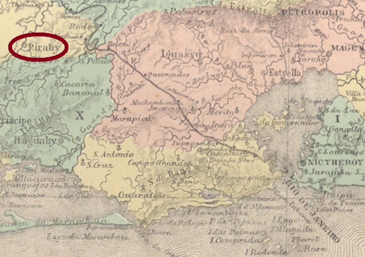
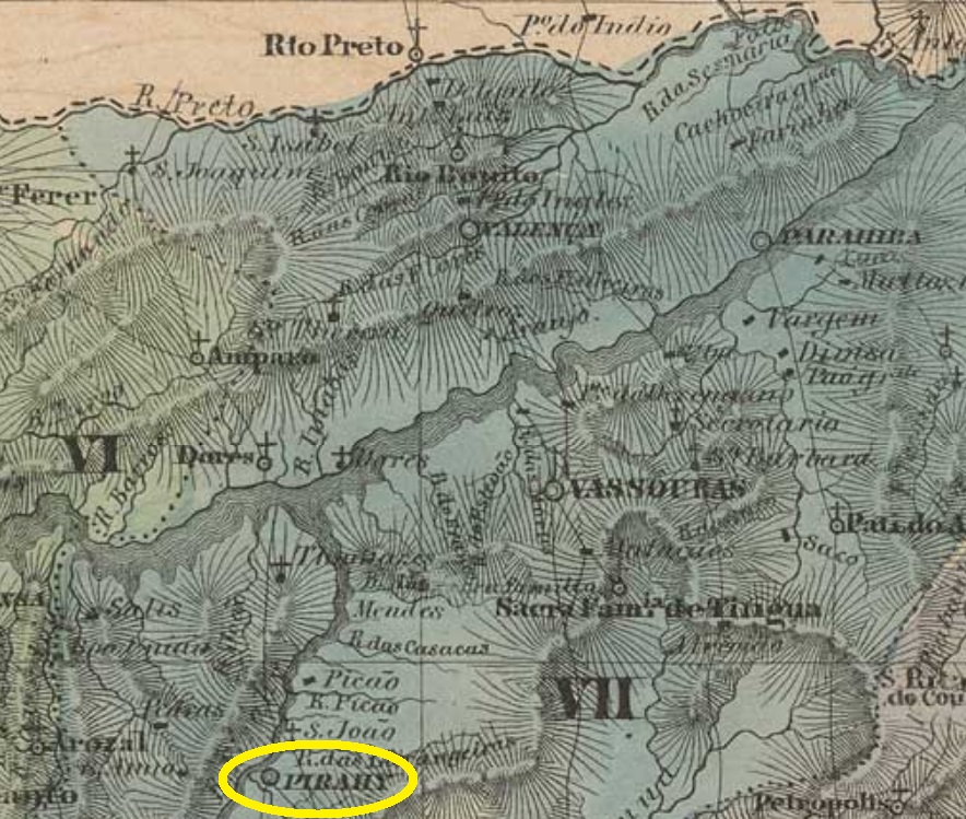
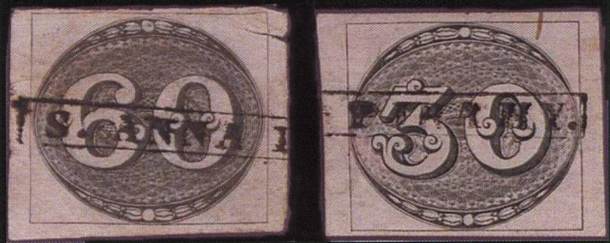
The old curato of Sant’Anna do Pirahy was created in October 1811 and declared a freguesia in October 1817 in the now extinct municipality of São João do Príncipe. It was situated round 100 km northwest of the imperial capital Rio de Janeiro and ascended to a villa in December 1837. It emancipated politically in October 1874, bearing since then the simplified toponym of Piraí.
According to Nova Monteiro (Administrações e Agencias Postaes do Brasil Imperio, in Brasil Filatelico/RJ, 1934-5; Reprint SPP 1994-1999), the local post office was created in October 1832. Only one imperial cancel featuring the entire name was found: SRJ-2365a was already presented by Henrique B. Ferreira (Catálogo ilustrado dos carimbos sobre os olhos-de-boi, 4a. ed, Porto Alegre, 2017, pg 164-5), as well as by the RHM catalogue under P-RJ-41 :
SRJ-2365a (H.B. Ferreira, op. cit.)
For later cancels featuring just PIRAHY see Koester’s Carimbologia XXXI.
Villiers de l’Ile Adam: Carta (…) da Provincia do Rio de Janeiro, 1850
Andere Namen: Sant’Anna, Pirahy
Siehe auch R. Koester: Carimbologia XXXI)
Der alte Curato von Sant’Anna do Pirahy wurde im Oktober 1811 gegründet und sechs Jahre später zur Freguesia erklärt. Er lag im inzwischen ausgestorbenen Município von São João do Príncipe, rund 100 km nordwestlich der kaiserlichen Hauptstadt Rio de Janeiro entfernt. Im Dezember 1837 wurde daraus eine Villa und im Oktober 1874 eine Stadt, die seitdem den vereinfachten Namen Piraí trägt.
Nova Monteiro (Administrações e Agencias Postaes do Brasil Imperio, in Brasil Filatelico/RJ, 1934-5; Reprint SPP 1994-1999) setzt das Gründungsdatum des örtlichen Postamts in October 1832. Lediglich eine postalische Entwertung der Kaiserzeit wurde bisher mit vollständigem Namen gefunden: SRJ-2365a wurde uns bereits durch Henrique B. Ferreira (Catálogo ilustrado dos carimbos sobre os olhos-de-boi, 4a. ed, Porto Alegre, 2017, pg 164-5), sowie durch den RHM Katalog (P-RJ-41) vorgestellt:
SRJ-2365a (H.B. Ferreira, op. cit.)
Für spätere Stempel nur mit der Inschrift PIRAHY siehe Koesters Carimbologia XXXI.
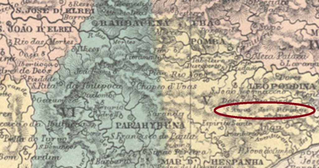
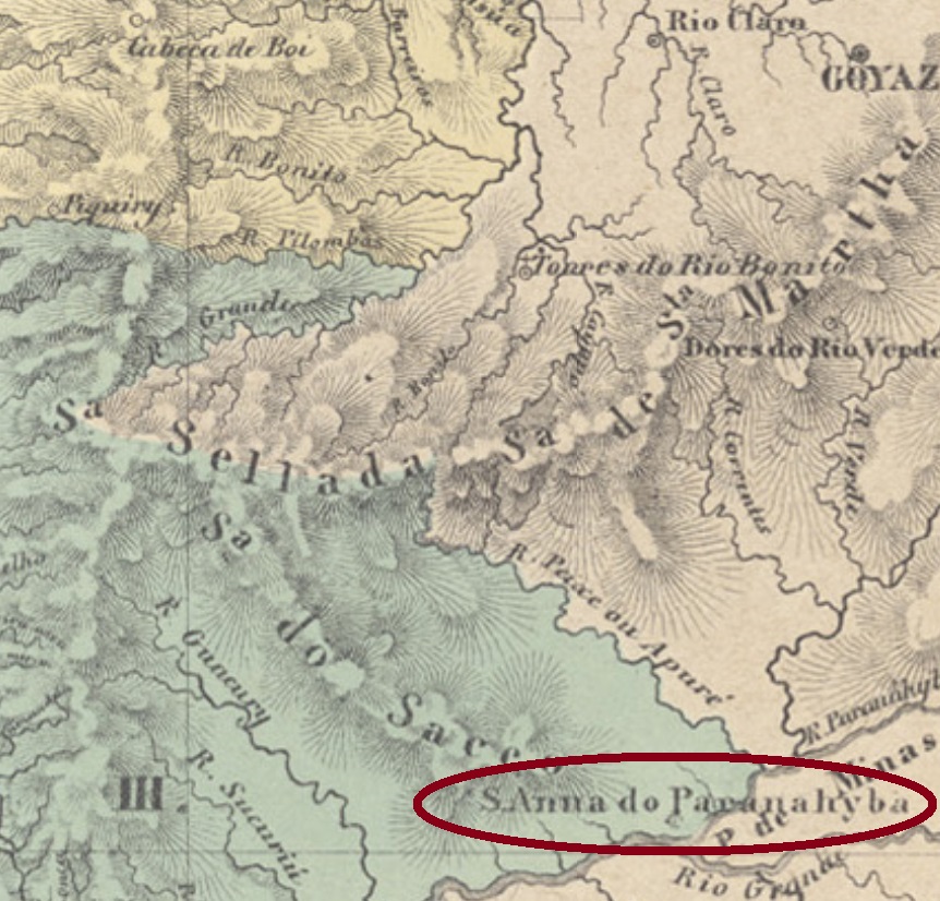
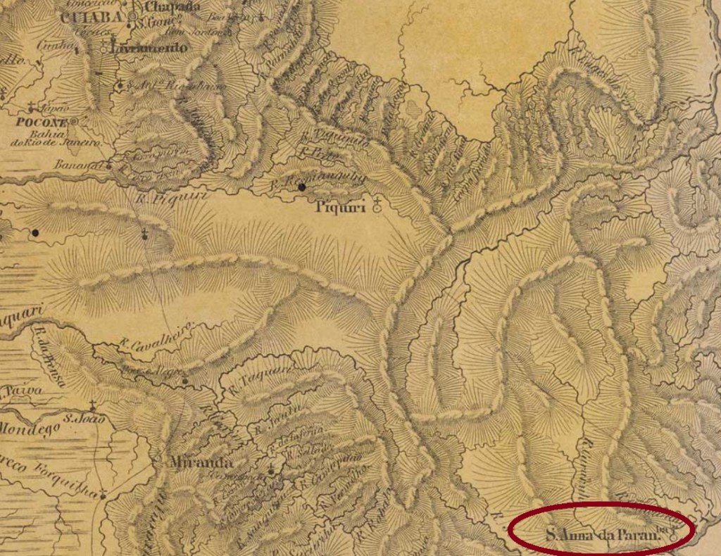
The Paranahyba (at that time also spelled Parnahiba) River to which this Sant’Anna refers is the same of SMG-2765, but now we are over 600 km downstream, in the former Mato Grosso province (now in the Mato Grosso do Sul state). This Sant’anna district was founded in April 1835 in the municipality of Cuiabá. The old provincial capital was situated almost 900 km northwest of the village! In July 1857 Sant’Anna do Paranahyba was elevated to a villa, and in July 1894, to a town. Since October 1938 the municipality is called simply Paranaíba.
Villiers de l’Ile Adam: Carta (…) da Provincia do Matto Grosso, 1850
Der Fluss Paranahyba (damals auch Parnahiba geschrieben), auf den sich diese Ortschaft bezieht, ist derselbe wie bei SMG-2765, nun aber befinden wir uns über 600 km stromabwärts, in der Provinz Mato Grosso (heute im Bundesstaat Mato Grosso do Sul). Diese Sant’Anna do Paranahyba war ab April 1835 ein Distrikt im Município von Cuiabá, obwohl die Provinzhauptstadt fast 900 km nordwestlich davon lag! Im Juli 1857 stieg er zur Villa auf, und im Juli 1894 zur Stadt. Seit Oktober 1938 heißt der Município einfach Paranaíba.
Laut Nova Monteiro (Administrações e Agencias Postaes do Brasil Imperio, in Brasil Filatelico/RJ, 1934-5; Reprint SPP 1994-1999), entstand das örtliche Postamt bereits im November 1848. Kein Poststempel der Kaiserzeit war bisher zu sehen.
Other names: Sant’Anna da Barra do Espírito Santo, Santana de Patos (1920)
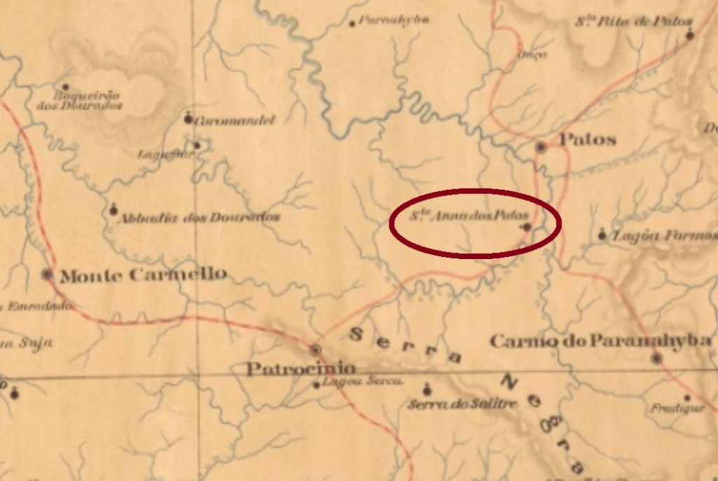
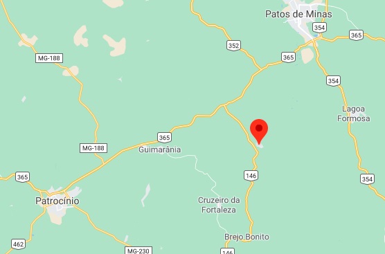
This Sant’Anna in the Minas Gerais province was since September 1844 the district of Sant’Anna da Barra do Espírito Santo in the municipality of Patrocínio, situated over 500 km northwest of the province capital Ouro Preto. In July 1872 the name was changed to Sant’Anna do Paranahyba and the locality was subordinated to Santo Antonio dos Patos. In December 1943 the toponym switched again, to the actual Santana de Patos, now in the municipality of Patos de Minas.
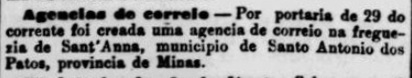
We have found two dates for the creation of the post office. Paula Sobrinho (História Postal de Minas Gerais, Belo Horizonte, 1997) asserts it took place in April 1885, but as early as July 1882 an agency was announced in the Rio press:
Jornal do Commercio, Rio de Janeiro, July 31, 1882
No postmark from the Empire has appeared until now.
GoogleMaps
Andere Namen: Sant’Anna da Barra do Espírito Santo, Santana de Patos (1920)
Diese Sant’Anna in der Provinz Minas Gerais province war ab September 1844 der Distrikt von Sant’Anna da Barra do Espírito Santo im Município von Patrocínio und lag über 500 km nordwestlich der Hauptstadt Ouro Preto entfernt. Im Juli 1872 wechselte der Ortsname zu Sant’Anna do Paranahyba und der Ort ging an die Gemeinde Santo Antonio dos Patos. Im Dezember 1943 erhielt die Ortschaft den aktuellen Namen Santana de Patos, diesmal im Município von Patos de Minas.
Wir haben zwei verschiedene Daten fürs Postamt gefunden. Paula Sobrinho (História Postal de Minas Gerais, Belo Horizonte, 1997) schreibt dafür den April 1885, aber bereits im Juli 1882 wurde eine Agentur in der Presse aus Rio angekündigt:
Jornal do Commercio, Rio de Janeiro, 31. Juli 1882
Kein Stempel aus der Kaiserzeit war bisher zu sehen.
Other names: Sant’Anna de Palmeiras, Palmeiras, Santa Branca, Bonfim
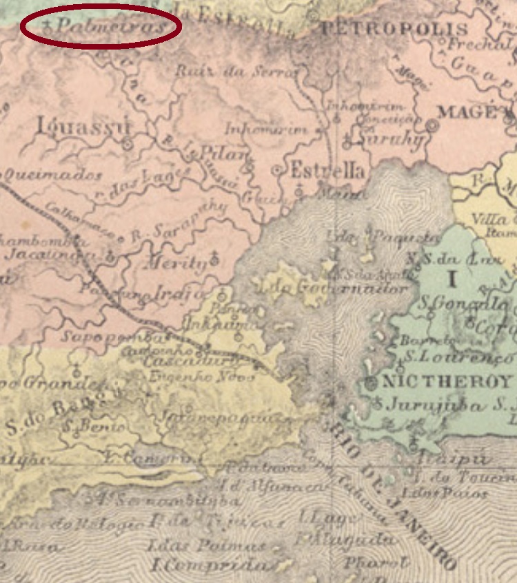
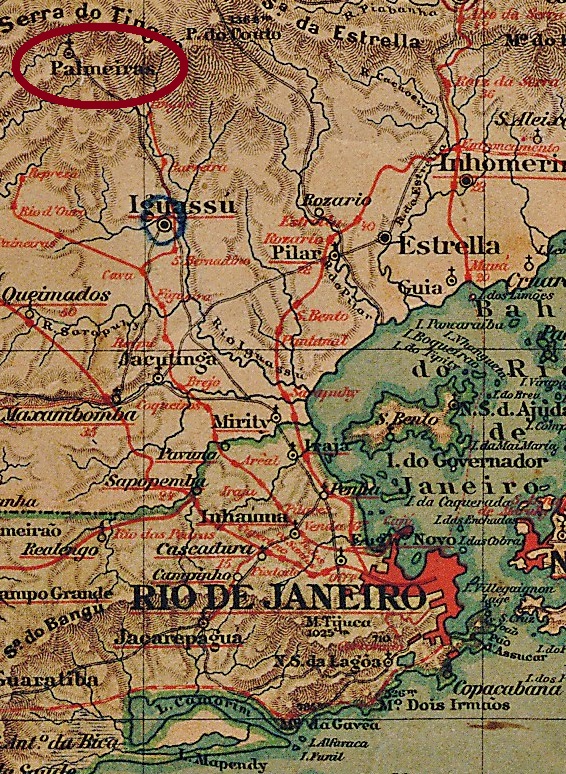
Santa’Anna das Palmeiras (=of the Palm Trees) was since October 1855 a district in the municipality of Iguassu, situated some 60 km north of the imperial capital Rio de Janeiro. The district status has remained until nowadays, although both locality and municipality changed their names and sites several times. So switched Iguassu to Maxambomba in May 1891 and was renamed Nova Iguaçu in November 1916, while Sant’Anna das Palmeiras at the end of the 19th century was relocated ca. 30 km towards south and renamed Santa Branca in November 1919 and Bonfim in January 1924. Now it is in the municipality of Duque de Caxias.
Paulo Novaes (agenciaspostais.com.br), on the other hand, tells us that this agency was eventually closed, to reopen in July 1872, and closed definitively in July 1892, probably due to the relocation of the village. The recreation year of 1872 is confirmed by the Imperial Mail Register (Tabella das Agencias do Correio do Imperio) of 1885.
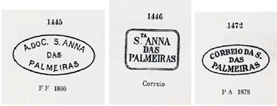
Not less than six imperial postmarks were found for this locality. The earliest one is the very rare SRJ-0865a (Coll. José A. Junges): an ellipse surrounding the legend FREG. DE STA. ANNA/DAS/PALMEIRAS. It was followed by three cancels which were already presented by Paulo Ayres (Catálogo de Carimbos Brasil-Império, S. Paulo, 1937, 1942). SRJ-0865b is P. Ayres #1445 and was used from the D. Pedro issues of 1866 on. SRJ-0865c is #1446 at P. Ayres and can be found from ca. 1872 on, i.e. at the post office reopening. SRJ-0685d is identical with Ayres #1472 and was used on the D. Pedro issues of 1878:
SRJ-0865b-d
The following cancel, SRJ-0685e (Coll. Karlheinz Wittig), presents a very curious misspelling within the double circle: S.A. DAS PALMIERAS (sic) can be found on stamps dated 1887 and 1888 at the centre. It was substituted by SRJ-0685f (Coll. Paulo Novaes) still before the end of the Empire. Here the double circle has the corrected legend S. ANNA DAS PALMEIRAS, with date of 1889 at the centre.
Almanak Laemmert, 1892
Andere Namen: Sant’Anna de Palmeiras, Palmeiras, Santa Branca, Bonfim (1924)
Santa’Anna das Palmeiras (=am Palmenhain) war ab Oktober 1855 ein Distrikt im Município von Iguassu, der ca. 60 km nördlich der kaiserlichen Hauptstadt Rio de Janeiro entfernt lag. Dieser Status ist bis heute erhalten geblieben, obwohl sowohl der Ort als auch die Gemeinde ihre Namen und Sitze mehrmals gewechselt haben. So wurde Iguassu zu Maxambomba nach einem Umzug im Mai 1891 und zu Nova Iguaçu im November 1916 umbenannt, während Sant’Anna das Palmeiras Ende des 19. Jahrhunderts etwa 30 km nach Süden verlegt wurde. Dann hieß der Ort ab November 1919 Santa Branca, ab Januar 1924 Bonfim, und heute liegt er im Município von Duque de Caxias.
Es sind zwei Daten für die Gründung des örtlichen Postamts überliefert: Nova Monteiro (Administrações e Agencias Postaes do Brasil Imperio, in Brasil Filatelico/RJ, 1934-5; Reprint SPP 1994-1999) behauptet, es fand im April 1857 statt. Dieses wird durch den Postbericht für 1860 und durch Aureo G. Santos (Agências de Correio Criadas e Suprimidas 1851, 1855, 1856 e 1857, in Brasil Filatélico #181, Rio de Janeiro) bestätigt:
Aureo G. Santos, op. cit.
Auf der anderen Seite berichtet Paulo Novaes (agenciaspostais.com.br), die Agentur schloss irgendwann später, eröffnete im Juli 1872 wieder und blieb in Betreib bis Juli 1892, wohl wegen der Ortsverlegung. Das Wiederöffnungsjahr wird durch das Verzeichnis der kaiserlichen Postämter (Tabella das Agencias do Correio do Imperio) von 1885 bestätigt.
Nicht weniger als sechs postalische Entwertungen im Kaiserreich wurden für diese Ortschaft gefunden. Die früheste ist die seltene SRJ-0865a (Samml. José A. Junges): eine Ellipse mit der Inschrift FREG. DE STA. ANNA/DAS/PALMEIRAS. Es folgten drei Stempel, die bereits durch Paulo Ayres (Catálogo de Carimbos Brasil-Império, S. Paulo, 1937, 1942) vorgestellt wurden. SRJ-0865b ist P. Ayres’ Nr.#1445 und wurde ab der D. Pedro-Ausgabe von 1866 verwendet. SRJ-0865c ist die Nr1446 bei P. Ayres und kommt ab ca. 1872 vor, d.h. etwa bei der Wiederöffnung des Postamtes. SRJ-0685d ist identisch mit Ayres’ Nr.1472 und wurde auf der D. Pedro-Ausgabe von 1878 gefunden:
SRJ-0865b-d
Der nächste Stempel, SRJ-0685e (Samml. Karlheinz Wittig), ist mit inneren Daten 1887 und 1888 auffindbar und weist einen sehr merkwürdigen Schreibfehler auf: im Doppelkreis liest man S.A. DAS PALMIERAS (sic). Er wurde durch SRJ-0685f (Samml. Paulo Novaes) noch vor dem Militärputsch von 1889 ersetzt. Hier hat der Doppelkreis die korrigierte Inschrift S. ANNA DAS PALMEIRAS, mit Datum aus 1889 in der Mitte.
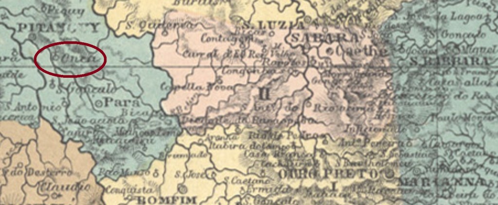
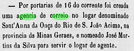
Other names: Arraial Novo da Onça, Sant’Anna da Onça do Rio de S. João Acima, Jaguaruna, Onça de Pitangui (1962)
See also Onça (Koester: Carimbologia XXIX)
This Sant’Anna da Onça (=of the Jaguar) was since July 1859 a freguesia on the São João River in the municipality of Pitanguy, over 200 km northwest of the provincial capital Ouro Preto. In September 1911 it changed to the newly founded municipality of Pequi, in August 1927 the new toponym was Jaguaruna, a tupi-guarani word which means black jaguar (Pantera Onca). It emancipated politically in December 1962 with the name Onça de Pitangui.
Both Nova Monteiro (Administrações e Agencias Postaes do Brasil Imperio, in Brasil Filatelico/RJ, 1934-5; Reprint SPP 1994-1999) and Paula Sobrinho (História Postal de Minas Gerais, Belo Horizonte, 1997) agree in asserting that the post office was created in April 1864. This can be confirmed by the Rio press:
Constitucional, RJ, April 19, 1864
Only one imperial cancel was seen, which the earliest one which mentions the saint. SMG-2760b (Coll. José A. Junges) has a simple double circle with the inscription S. A. DA ONÇA. The dates at the centre were found for the period 1878-1889.
For cancels featuring only Onça see Koester, Carimbologia XXIX.
Atlas do Imperio do Brasil, 1868
Andere Namen: Arraial Novo da Onça, Sant’Anna da Onça do Rio de S. João Acima, Jaguaruna, Onça de Pitangui (1962)
Siehe auch Onça (Koester: Carimbologia XXIX)
Diese Sant’Anna da Onça (=des Jaguars) war ab Juli 1859 eine Freguesia am Fluss São João im Município von Pitanguy, die über 200 km nordwestlich der Provinzhauptstadt Ouro Preto entfernt lag. Im September 1911 wechselte sie zum neu gegründeten Município von Pequi, ab August 1927 hieß der Ort Jaguaruna, ein tupi-guarani-Wort, das schwarze Jaguar (Pantera Onca) bedeutet. In Dezember 1962 stieg die Ortschaft zum Município unter den Namen Onça de Pitangui.
Sowohl Nova Monteiro (Administrações e Agencias Postaes do Brasil Imperio, in Brasil Filatelico/RJ, 1934-5; Reprint SPP 1994-1999) als auch Paula Sobrinho (História Postal de Minas Gerais, Belo Horizonte, 1997) sind sich einig, dass das Postamt dort im April 1864 entstand. Dies kann durch die Rio Presse bestätigt werden:
Constitucional,RJ, 19. April 1864
Nur ein Stempel mit dem vollen Ortsnamen war im Kaiserreich zu finden. SMG-2760b (Coll. José A. Junges) besteht aus einem einfachen Doppelkreis mit der Inschrift S. A. DA ONÇA. Die Daten in der Mitte stammen aus dem Zeitraum 1878-1889.
Für Stempel nur mit Onça siehe Koester, Carimbologia XXIX.
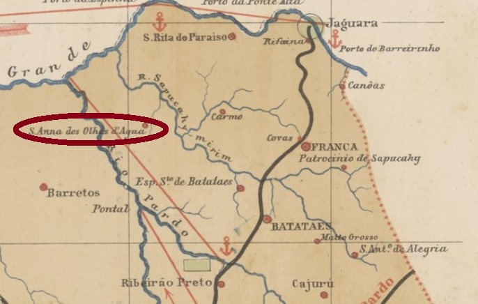
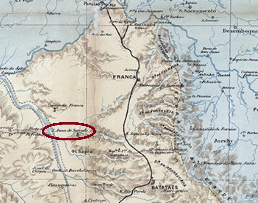
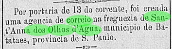
Sant’Anna dos Olhos d’Água (= of the Well Field) was since April 1859 a freguesia of the municipality of Batataes, situated between the Sapucahy-Mirim and the Ipuã Rivers, over 400 km north of the provincial capital São Paulo. It was also called Sant’Anna de Batataes or Sant’Anna do Serrado and changed to the municipality of Espírito Santo de Batataes in March 1885. It later belonged to the newly founded municipalities of Orlandia (from November 1909 on) and São Joaquim (from December 1927 on). In November 1944 the toponym changed to Ipuã, a tupi-guarani word that means island, and the locality emancipated politically in December 1948.
The local post office under the toponym Sant’Anna dos Olhos d’Água was created in January 1887, as reported by the São Paulo press:
Correio Paulistano, January 18, 1887
The only known imperial postmark is SSP-1900a (Coll. José A. Junges): a double circle with the inscription S.ANNA DOS OLHOS D’AGUA above and a circular ornament below, with a cross-like cut inside. The dates at the centre are between 1889 and 1908.
For earlier postmarks under Sant’Anna de Batataes see SSP-1898.
C. Rath: Provincia de São Paulo, 1886
Andere Namen: Sant’Anna do Serrado, Ipuã
Siehe auch Sant’Anna de Batataes (SSP-1898)
Sant’Anna dos Olhos d’Água (= von den Wasserquellen) war ab April 1859 eine Freguesia im Municipio von Batataes und lag zwischen den Flüssen Sapucahy-Mirim und Ipuã, über 400 km nördlich der Provinzhauptstadt São Paulo entfernt. Sie wurde auch Sant’Anna de Batataes oder Sant’Anna do Serrado genannt und ging im März 1885 zum Município von Espírito Santo de Batataes über. Später war die Ortschaft ein Distrikt der frisch gegründeten Municípios von Orlandia (ab November 1909) und São Joaquim (ab December 1927). Im November 1944 wechselte der Ortsname zu Ipuã, ein Wort der tupi-guarani-Sprache, das Insel bedeutet. Im Dezember 1948 wurde aus Ipuã ein eigenständiger Município.
Das örtliche Postamt entstand im Januar 1887 unter den Namen Sant’Anna dos Olhos d’Água, wie die Presse aus São Paulo berichtet:
Correio Paulistano, 18. Januar 1887
Der einzige Stempel aus der Kaiserzeit ist SSP-1900a (Samml. José A. Junges): ein Doppelkreis mit den Inschriften S.ANNA DOS OLHOS D’AGUA oben und einem kreisähnlichen Ornament unten, das kreuzförmig geschnitten ist. Die Daten in der Mitte stammen aus dem Zeitraum 1889 – 1908.
Für frühere Stempel unter Sant’Anna de Batataes siehe SSP-1898.
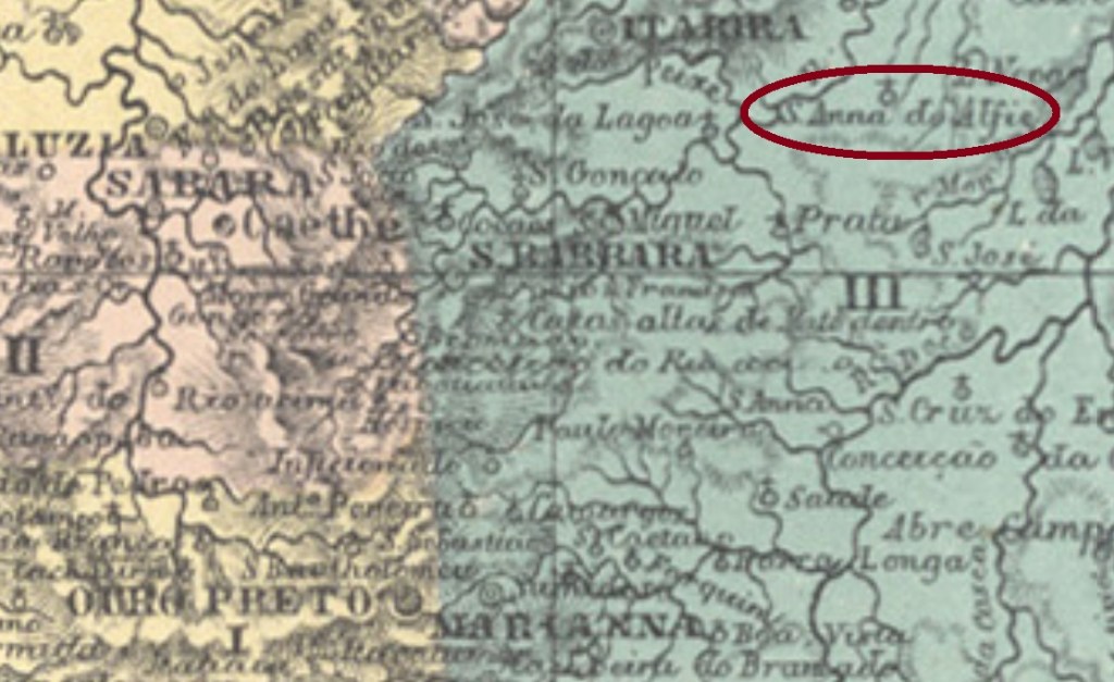
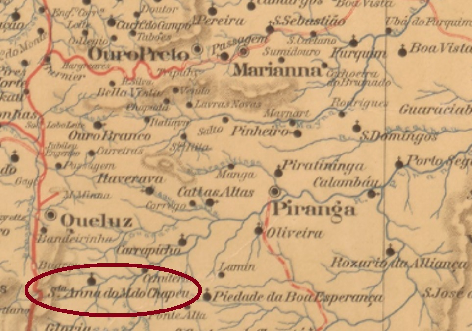
Other names: Sant’Anna do Morro do Chapee, Morro do Chapeo, Catauá, Santana dos Montes
This Sant’Anna do Morro do Chapéo (=of the Hat Mountain) was since 1840 a district of the municipality of Queluz, situated round 80 km southwest of the province capital Ouro Preto. After that, the toponym has changed three times: in September 1923 to Morro do Chapéu, in December 1943 to Catauá, and in December 1948 to Santana dos Montes, which also was the the name of the municipality established in December 1962.
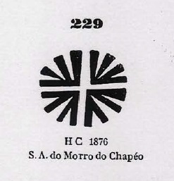
According to Paula Sobrinho (História Postal de Minas Gerais, Belo Horizonte, 1997), the local post office was created in November 1873. Three imperial postmarks and two mute cancellations were found, an impressive number for such a small locality. SMG-2755a is the earliest among them, it circulated at least between 1879 and 1884 and was already presented by Paulo Ayres in his Catálogo de Carimbos Brasil-Império (S. Paulo, 1937, 1942), page 125:
SMG-2755a (P.A.)
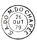
The next cancel, SMG-2755b (Coll. José A. Junges), was found on a single example, dated 1886. Unfortunately the left side went off stamp margins, but the double circle has probably the inscription (S.A. DO M.) DO CHAPEO, with date inside. It was followed by SMG-2755c (Coll. Márcio Protzner), also a double circle, now with the inscriptions S. ANNA DO MO. DO CHAPEO above and (MINAS) below. The dates at the centre were found for the period 1889-1891.
Both mute cancels were already shown by P. Ayres (op.cit.). The earlier one would be #229, for it was found on D. Pedro issues of 1876:
Paulo Ayres #229
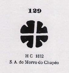
The other mute cancel has #129 and was often used in combination with SMG-2755a between 1882 and 1884:
Paulo Ayres #129Mappa de Minas Geraes, 1910
Andere Namen: Sant’Anna do Morro do Chapee, Morro do Chapeo, Catauá, Santana dos Montes
Diese Sant’Anna do Morro do Chapéo (=vom Hutberg) war seit 1840 ein Distrikt im Município von Queluz und lag rund 80 km südwestlich der Provinzhauptstadt Ouro Preto entfernt. Danach wurde der Ortsname dreimal gewechselt: im September 1923 zu Morro do Chapéu, im Dezember 1943 zu Catauá, und im Dezember 1948 zu Santana dos Montes. Letztere ist auch die Bezeichnung zum im Dezember 1962 gegründeten Município.
Laut Paula Sobrinho (História Postal de Minas Gerais, Belo Horizonte, 1997) gibt es dort ein Postamt seit November 1873. Drei postalische Entwertungen und zwei stumme Stempel waren auffindbar, eine beeindruckende Zahl für diese kleine Ortschaft. SMG-2755a ist der früheste Stempel, er war zumindest zwischen 1879 und 1884 in Gebrauch und wurde bereits durch Paulo Ayres in seinem Catálogo de Carimbos Brasil-Império (S. Paulo, 1937, 1942) auf S. 125 präsentiert:
SMG-2755a (P.A.)
Die nächste Abstempelung, SMG-2755b (Samml. José A. Junges) wurde bisher nur einmal gefunden. Leider war die linke Seite nicht auf der Marke zu sehen, aber die Inschrift innerhalb des Doppelkreises war vermutlich (S.A. DO M.) DO CHAPEO, mit Datum d. Jahres 1886. Ihm folgte SMG-2755c (Samml. Márcio Protzner), auch mit einem Doppelkreis, nun aber mit den Inschriften S. ANNA DO MO. DO CHAPEO oben und (MINAS) unten. Die Daten in der Mitte wurden für den Zeitraum 1889-1891 ermittelt.
Beide stummen Stempel waren bereits bei P. Ayres (op. cit.) zu sehen. Der frühere hat Nr. 229 und wurde angeblich auf D. Pedro-Ausgaben von 1876 gefunden:
Paulo Ayres Nr. 229
Der andere stumme Stempel hat die Nr. 129 und wurde oft in Begleitung von SMG-2755a zwischen 1882 und 1884 verwendet:
This toponym rises a question about its correct writing: is it DO, DE or DOS Mattos? All three variants occur abundantly, sometimes even mixed together in the same publication. We decided to write DO Mattos, for it is both the first official name and the actual version, as long as the postal cancels – whenever they may appear – don’t have another spelling.
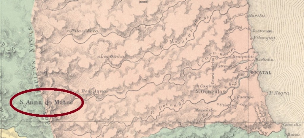
According to the Brazilian Institute for Geography and Statistics (IBGE), the locality has originated from the farm Bom Bocadinho (=Delicious Little Piece), whose owner Manoel José de Mattos had decided to build a chapel in honor to the Holy Anna, and was situated in the municipality of Assú, over 200 km west of the provincial capital Natal. Still in colonial times, in August 1821, it was made a district, which ascended to a Villa in October 1836. Between 1853 and 1855 it was degraded again to a district, before recovering the villa status. Since October 1927 it is the town and municipality of Santana do Matos.
Villiers de l’Ile Adam: Charta (…) da Provincia do Rio Grande do Norte, 1848
Über den Ortsnamen stellt sich gleich die Frage: ist es DO, DE oder DOS Mattos? Alle drei Varianten kommen oft vor, manchmal sogar gemeinsam in derselben Veröffentlichung. Wir entschieden uns für DO Mattos, da diese Schreibweise sowohl die erste offizielle als auch die aktuelle ist, so lange die Poststempel der Kaiserzeit – wenn sie mal zu sehen sein werden – keine andere Alternative erzwingen.
Laut dem Brasilianischen Institut für Geografie und Statistik (IBGE) hat diese Ortschaft ihren Ursprung im Großgrundbesitz Bom Bocadinho (=Leckeres Stückchen), dessen Eigentümer Manoel José de Mattos eine Kapelle für die Heilige Anna bauen ließ, und lag in der Gemarkung Assú, über 200 km westlich der Provinzhauptstadt Natal entfernt. Noch in der Kolonie-Zeit, im August 1821, wurde daraus ein Distrikt, der im Oktober 1836 zur Villa aufstieg. Zwischen 1853 und 1855 wurde der Ort wieder zum Distrikt herabgesetzt, bevor der Villa-Status zurück kehrte. Seit Oktober 1927 ist es die Stadt und Município von Santana do Matos.
Es gibt zwei Entstehungsdaten für das örtliche Postamt, ein sicherer Hinweis dafür, dass es mindestens einmal geschlossen wurde. Nova Monteiro (Administrações e Agencias Postaes do Brasil Imperio, in Brasil Filatelico/RJ, 1934-5; Reprint SPP 1994-1999) behauptet, es fand im September 1846 statt, während das Verzeichnis der kaiserlichen Postämter (Tabella das Agencias do Correio do Imperio) von 1885 die Agentur ab 1874 auflistet. Kein Poststempel der Kaiserzeit ist bisher aufgetaucht.
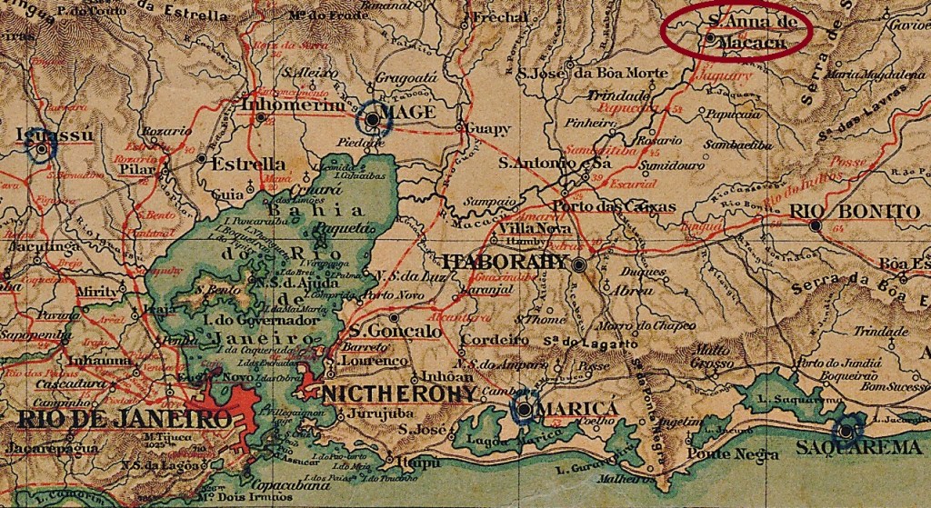
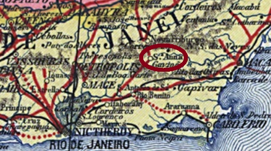
Other names: Sant’Anna de Japuíba, Santana, Japuíba
See also Sant’Anna da Santíssima Trindade (SRJ-0860)
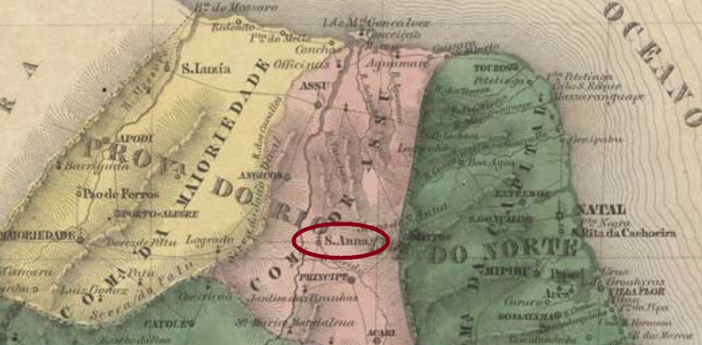
The Arraial of Sant’Anna da Santissima Trindade (= of the Holiest Trinity) was founded in November 1868 on the east bank of the Macacu River, round 100 km northeast of the imperial capital Rio de Janeiro, and belonged to the now extinguished Villa of Santo Antonio de Sá. In September 1877 it ascended to a Villa under the name of Santa’Anna de Macacu, which changed the toponym to Sant’Anna de Japuíba in December 1898. It received even the town status in December 1929, but apparently has not improved significantly since then, for it was degraded to the district of Santana in the municipality of Cachoeiras in December 1938. Five years later it was renamed Japuíba, and Cachoeiras became Cachoeiras de Macacu.
According to Paulo Novaes (agenciaspostais.com.br), the local post office was created ca. 1861 and operated until March 1899. Since the first cancel does not mention the Macacu River, it will be presented while discussing Sant’Anna da Santíssima Trindade (SRJ-0860).
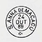
Four later 19-century post cancels were found, all of them have double circles. SRJ-1530a (Coll. José A. Junges) shows simply S. A. DE MACACÚ, and the dates inside were found between 1877 and 1884. Sometimes the year indication is missing. SRJ-1530b (Coll. José A. Junges) presents STA. ANNA DE MACACÚ above and a diamond ornament below, whoich consists of four small diamonds. Dates from 1885 to 1887 inside. SRJ-1530c (Coll. Dieter Kerkhoff) was found with dates within the period 1888-1889 and has the legend S. ANNA DE MACACÚ above and a double XX below forming a cross at a central black point. Consequently, it differs considerably from the image provided by Paulo Ayres on page 125 of his Catálogo de Carimbos Brasil-Império, (S. Paulo, 1937, 1942):
P.Ayres (op. cit.) pg. 125
The last cancel, SRJ-1530d (Coll. Karlheinz Wittig), can be already republican, for it shows dates from 1890 to 1891: the inscription above is now SA. ANNA DE MACACÚ, and the ornament below is cross-like.
Carta da Republica dos Estados Unidos do Brazil, 1892
Andere Namen: Sant’Anna de Japuíba, Santana, Japuíba
Siehe auch Sant’Anna da Santíssima Trindade (SRJ-0860)
Der Arraial (Dorf) von Sant’Anna da Santissima Trindade (= der Heiligsten Dreifaltigkeit) wurde im November 1868 am Ostufer des Flusses Macacu gegründet, lag rund 100 km nordöstlich der kaiserlichen Hauptstadt Rio de Janeiro entfernt und gehörte der inzwischen ausgelöschten Villa von Santo Antonio de Sá. Im September 1877 stieg er zur Villa auf, mit dem Namen Santa’Anna de Macacu, der allerdings im Dezember 1898 zu Sant’Anna de Japuíba wechselte. Er wurde im Dezember 1929 sogar eine Stadt, die allerdings nicht besonders gut gedeihte: schon im Dezember 1938 wurde sie zum Distrikt von Santana im Município von Cachoeiras degradiert. Fünf Jahre später kehrte der Ortsname Japuíba zurück, während aus Cachoeiras Cachoeiras de Macacu wurde.
Laut Paulo Novaes (agenciaspostais.com.br) entstand das örtliche Postamt ca. 1861 und blieb bis März 1899 in Betrieb. Da aber der erste Stempel den Macacu-Fluss gar nicht erwähnt, wird er bei Sant’Anna da Santíssima Trindade (SRJ-0860) vorgestellt.
Vier spätere Poststempel wurden auffindbar, die alle Doppelkreise haben. SRJ-1530a (Samml. José A. Junges) zeigt einfach S. A. DE MACACÚ, und die Daten in der Mitte wurden für den Zeitraum 1877-1884 gefunden. Manchmal fehlt die Jahresangabe. SRJ-1530b (Samml. José A. Junges) hat STA. ANNA DE MACACÚ oben und einen rautenförmigen Ornament unten, das aus vier kleinen Rauten besteht. Daten im Inneren zwischen 1885 und 1887. SRJ-1530c (Samml. Dieter Kerkhoff) wurde bisher mit Daten von 1888-1889 gesehen und hat die Legende S. ANNA DE MACACÚ oben und zwei XX unten, die sich kreuzweise schneiden an einem schwarzen Punkt in der Mitte. Dieser Stempel weicht also deutlich vom Bild ab, das Paulo Ayres auf S. 125 seines Catálogo de Carimbos Brasil-Império, (S. Paulo, 1937, 1942) veröffentlicht hat:
P.Ayres (op. cit.) S. 125
Der letzte Stempel, SRJ-1530d (Samml. Karlheinz Wittig), kann bereits republikanisch sein, denn seine Daten wurden bisher für 1890 und 1891 gefunden: die Inschrift oben lautet nun SA. ANNA DE MACACÚ, das Ornament unten ist in Kreuzform.