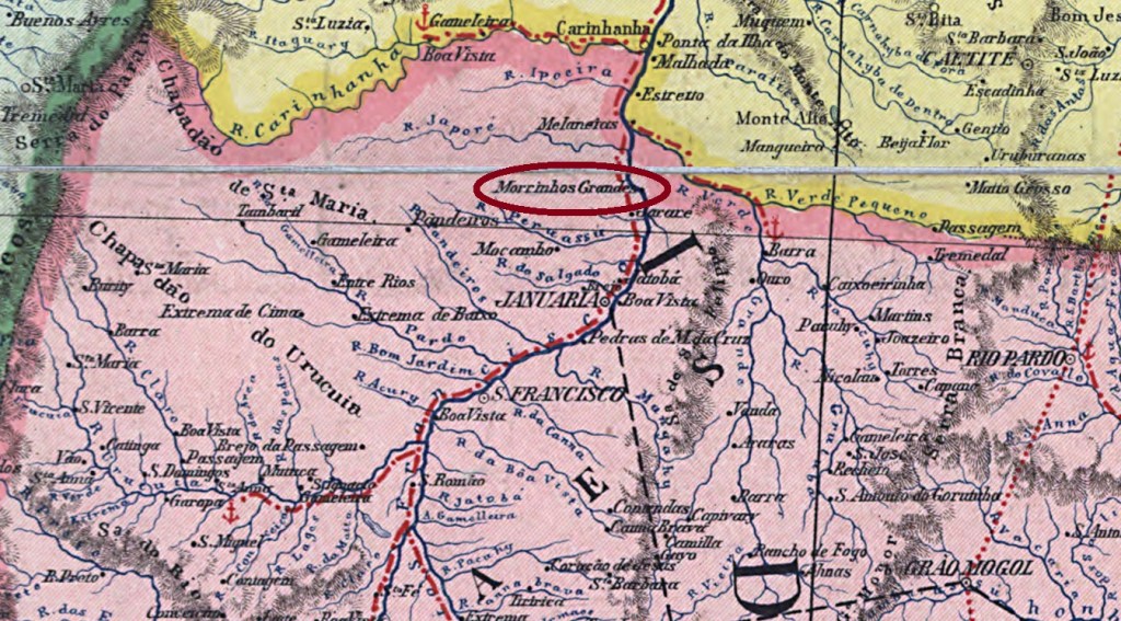
Other names: Morrinhos Grandes, Mathias/Matias Cardoso (1923)
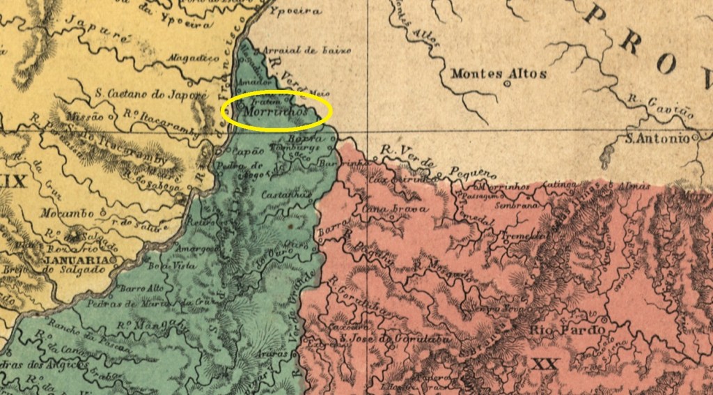
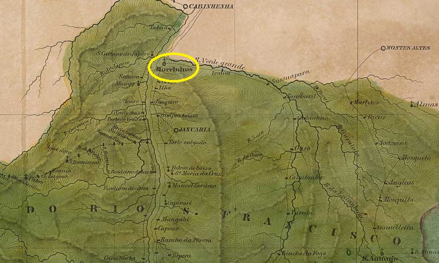
The Freguesia de N. Sra. da Conceição de Morrinhos had been in existence since 1755. It was located on the east bank of the São Francisco River, 870 kilometres north of the future provincial capital of Ouro Preto. The Freguesia then changed jurisdiction three times: In June 1833, it became part of the Vila de Brejo do Amparo, in September 1884 part of the Vila de Januária, and in September 1923, now as the Distrito de Mathias Cardoso, part of the Vila da Manga. Since April 1992, Mathias Cardoso (the current spelling) has been an independent município. The name commemorates a 17th-century bandeirante.
According to the press in Rio de Janeiro, there has been a post office there since April 1885.
Jornal do Commercio/RJ, 24 April 1885
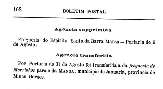
This was moved to Vila da Manga in August 1889.
Boletim Postal, 1889
The agency was not reopened until June 1900, as Paula Sobrinho writes in ‘História Postal de Minas Gerais’ (Belo Horizonte, 1997). No imperial postmark from Morrinhos in the province of Minas Gerais has been found to date.
Villiers de l’Ile Adam: Carta (…) da Provincia de Minas Geraes, 1849
Outros nomes: Morrinhos Grandes, Mathias/Matias Cardoso (1923)
A Freguesia de N. Sra. da Conceição de Morrinhos era conhecida desde 1755. Situava-se na margem leste do São Francisco, 870 quilômetros ao norte da futura capital provincial, Ouro Preto. Posteriormente, a Freguesia mudou três vezes de jurisdição: em junho de 1833, passou a fazer parte da Vila de Brejo do Amparo; em setembro de 1884, da Vila de Januária; e, em setembro de 1923, agora como Distrito de Mathias Cardoso, da Vila da Manga. Desde abril de 1992, Mathias Cardoso (grafia atual) é um município independente. O nome lembra um bandeirante do século XVII.
Segundo a imprensa do Rio de Janeiro, havia uma agência dos correios no local desde abril de 1885.
Jornal do Comércio/RJ, 24/04/1885
Esta foi transferida para a Vila da Manga em agosto de 1889.
Boletim Postal, 1889
A agência só foi reaberta em junho de 1900, como escreve Paula Sobrinho em “História Postal de Minas Gerais” (Belo Horizonte, 1997). Até o momento, não foi encontrado nenhum carimbo postal imperial de Morrinhos, na província de Minas Gerais.
Carta da Republica dos Estados Unidos do Brazil, 1892
Andere Namen: Morrinhos Grandes, Mathias/Matias Cardoso (1923)
Die Freguesia de N. Sra. da Conceição de Morrinhos war seit 1755 überliefert. Sie lag am Ostufer des São Francisco, 870 Kilometer nördlich der späteren Provinzhauptstadt Ouro Preto. Danach wechselte die Freguesia dreimal ihre Zuständigkeit: Im Juni 1833 wurde sie Teil der Vila de Brejo do Amparo, im September 1884 der Vila de Januária und im September 1923, nun als Distrito de Mathias Cardoso, der Vila da Manga. Seit April 1992 ist Mathias Cardoso (so die heutige Schreibweise) ein eigenständiger Município. Der Name erinnert an einen Bandeirante des 17. Jahrhunderts.
Wie aus der Presse in Rio de Janeiro hervorgeht, gab es dort seit April 1885 ein Postamt.
Jornal do Commercio/RJ, 24.04.1885
Dieses wurde im August 1889 nach Vila da Manga verlegt.
Boletim Postal, 1889
Die Agentur wurde erst im Juni 1900 wiedereröffnet, wie Paula Sobrinho in „História Postal de Minas Gerais” (Belo Horizonte, 1997) schreibt. Bisher wurde kein kaiserlicher Poststempel aus Morrinhos in der Provinz Minas Gerais gefunden.
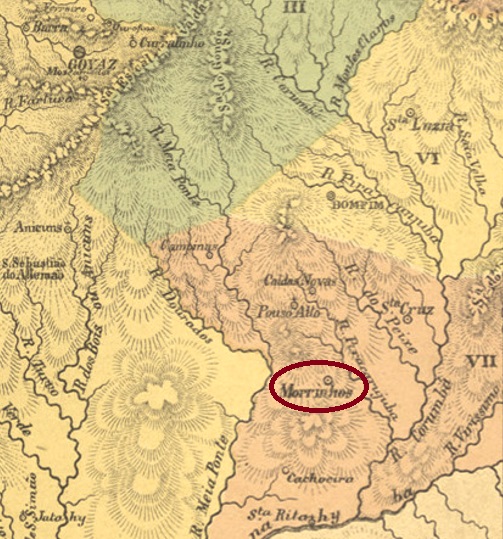
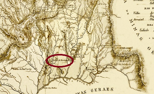
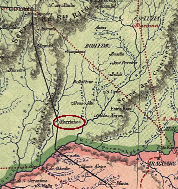
Other names: N. Sa. do Carmo dos Morrinhos, Villa Bella do Parnahyba
See also Villa Bella de Morrinhos (VGO-0290)
The parish of Villa Bella do Parnahyba was founded in July 1843 and was situated – despite the river in the name – barely 100 km north of the Parnahyba and 270 km south of the provincial capital Goyaz (today Goiás Velho). In July 1857, it was promoted as a vila, but just two years later came its demotion as a district in the Município of Pouso Alto. In July 1871, the resurgence took place as Villa Bella de N. Sra. do Carmo do Parnahyba, which became the town of Morrinhos in August 1882. The Morrinhos are three small mountains, yet much closer than the river.
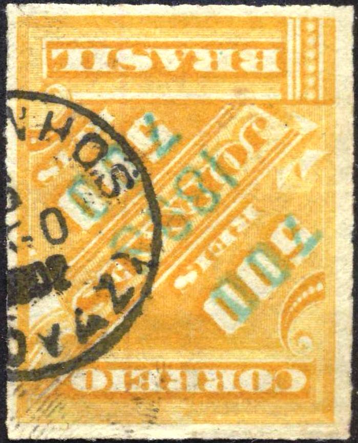
The local post office was established in 1880, as shown in the Directory of Imperial Post Offices (Tabella das Agencias do Correio do Imperio, Rio de Janeiro, 1885). The oldest cancel has the inscription V.B. DE MORRINHOS (see SGO-0290). The successor is VGO-0290b/0115a (Coll. FM):
VGO-0290b/MGO-0115a (FM) 1890-1902Carta da Provincia de Goyaz, 1874
Outros nomes: N. Sa. do Carmo dos Morrinhos, Villa Bella do Parnahyba
Ver também Villa Bella de Morrinhos (VGO-0290)
A paróquia de Villa Bella do Parnahyba foi fundada em julho de 1843 e estava situada – embora mencionasse o rio – a uns 100 km ao norte do Parnahyba e 270 km ao sul da capital provincial Goyaz (hoje Goiás Velho). Em julho de 1857, foi promovido como vila, mas logo dois anos depois veio seu rebaixamento como distrito no Município de Pouso Alto. Em julho de 1871, subiu novamente como a Villa Bella de N. Sra. do Carmo do Parnahyba, que se tornou a cidade de Morrinhos em agosto de 1882. Os morrinhos são três pequenas montanhas, ben mais próximas do que o rio.
A agência postal local foi estabelecida em 1880, como mostra a Tabella das Agencias do Correio do Império (Rio de Janeiro, 1885). O carimbo postal mais antigo tem a inscrição V.B. DE MORRINHOS (veja VGO-0290). O sucessor é VGO-0290b/MGO-0115a (Col. FM):
VGO-0290b/MGO-0115a (FM) 1890-1902Carta da Republica dos Estados Unidos do Brazil, 1892
Andere Namen: N. Sa. do Carmo dos Morrinhos, Villa Bella do Parnahyba
Siehe auch Villa Bella de Morrinhos (VGO-0290)
Die Pfarrei von Villa Bella do Parnahyba entstand im Juli 1843 und lag – obwohl der Fluss im Namen stand – knapp 100 km nördlich des Parnahyba und 270 km südlich der Provinzhauptstadt Goyaz (heute Goiás Velho) entfernt. Im Juli 1857 erfolgte der Aufstieg als Vila, aber gleich zwei Jahre später kam die Degradierung als Distrikt im Município von Pouso Alto. Im Juli 1871 fand der Wiederaufstieg als Villa Bella de N. Sra. do Carmo do Parnahyba, die im August 1882 zur Stadt Morrinhos wurde. Die Morrinhos sind drei kleine Berge, die doch wesentlich näher als der Fluss liegen.
Das örtliche Postamt wurde 1880 ins Leben gerufen, wie aus dem Verzeichnis der kaiserlichen Postämter (Tabella das Agencias do Correio do Imperio, Rio de Janeiro, 1885) hervorgeht. Zwei Poststempel in Kreisform wurden fürs 19. Jahrhundert gefunden. Der älteste Poststempel hat oben die Inschrift V.B. DE MORRINHOS (siehe VGO-0290). Der Nachfolger ist VGO-0290b/MGO-0115a (Samml. FM):
Villiers de l’Ile Adam: Carta (…) da Provincia de São Paulo, 1847
Other names: Acuantan, Nhundiaquara
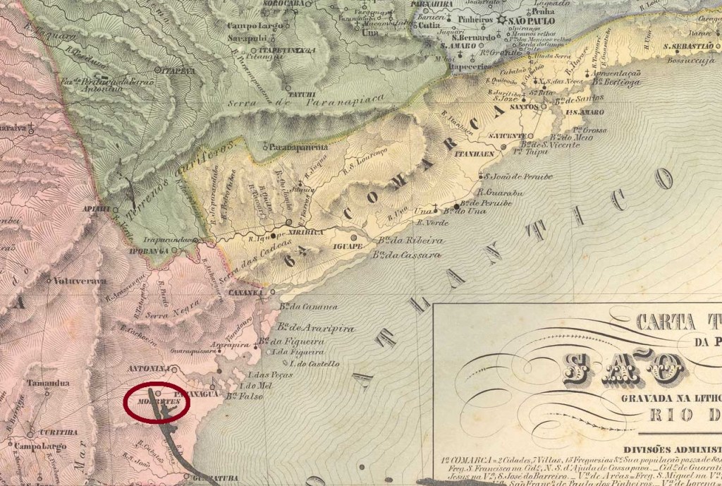
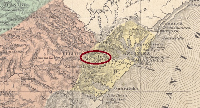
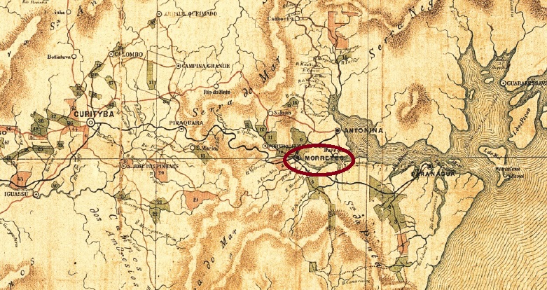
The history of this ancient settlement raises some questions about the place name that have not yet been clarified. Two names of indigenous origin have been found: ‘Acuantan’ (mountainous land) and ‘Nhundiaquara’ (home of the Jundiás, a species of catfish commonly found in Brazil). However, it is not yet known when exactly these names were used. The place has been known since at least 1721. It belonged to the Vila de Paranaguá, was located on the south bank of the Nhundiaquara and was 60 km east of the later provincial capital Curitiba. In May 1811, it was subordinated to the Freguesia de N. Sra. do Porto de Morretes and the Vila de Antonina. It is said to have become a vila in March 1841 and the city of Nhundiaquara in May 1869, but this name is hardly ever found in the regional press. A sure indication that it was unpopular. Since April 1870, it has officially been called Município de Morretes.
As Nova Monteiro writes in ‘Administrações e Agencias Postaes do Brasil Imperio’ (Brasil Filatelico/RJ, 1934–1935; reprinted by SPP 1994–1999), there has been a post office there since September 1832. At that time, Morretes was still part of the province of São Paulo; Paraná only became a province in July 1854.
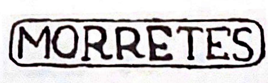
To date, all postmarks bear the place name Morretes, starting with the pre-philatelic MPR-0130a, which was recorded in the RHM catalogue with the abbreviation P-SP-26.
MPR-0130a (RHM P-SP-26) 1841-1844ff
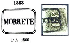
This was followed by MPR-0130b, which also appears in blue and was given the number 1363 in P. Ayres’ Catálogo de Carimbos Brasil-Império (S. Paulo, 1937, 1942). However, the last letter in the place name is missing in Ayres’ illustration:
MPR-0130b (P.A. 1363-recte EB) 1850ff-1866ff
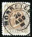
This was followed by the double circle MPR-0130c (illustration from the Internet):
MPR-0130c (EB) 1876ff-1891
R. Koester showed the registered postmark MPR-0130d in Carimbologia XXVII:
MPR-0130d (RK) 1887
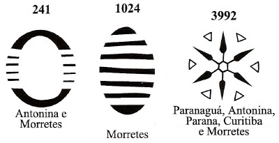
And James Dingler and Klerman W. Lopes showed three mute postmarks used in Morretes in Mute Cancellations of the Brazil Empire / Carimbos Mudos do Brasil Império (Brazil Philatelic Association, Rio de Janeiro, 2000):
BPA 241 – 1024 (P.A. 363), 1883ff – 3992 (P.A. 783), 1866ff-1882, the last in purpleAtlas do Imperio do Brasil, 1868
Outros nomes: Acuantan, Nhundiaquara
A história deste antigo povoado levanta algumas questões sobre o nome do local, que ainda não foram esclarecidas. Foram encontrados dois nomes de origem indígena: “Acuantan” (terra montanhosa) e “Nhundiaquara” (terra dos jundiás, um peixe comum no Brasil). No entanto, até o momento não se sabe exatamente quando eles foram usados. O local é conhecido desde 1721, no mínimo. Pertencia à Vila de Paranaguá, ficava na margem sul do Nhundiaquara e estava localizado 60 km a leste da futura capital provincial, Curitiba. Em maio de 1811, foi subordinada à Freguesia de N. Sra. do Porto de Morretes e à Vila de Antonina. Supostamente, tornou-se vila em março de 1841 e cidade de Nhundiaquara em maio de 1869, mas esse nome quase não aparece na imprensa regional. Um indício claro de que era impopular. Desde abril de 1870, ela deve se chamar oficialmente Município de Morretes.
Como escreve Nova Monteiro em “Administrações e Agencias Postaes do Brasil Imperio” (Brasil Filatelico/RJ, 1934–1935; reimpressão SPP 1994–1999), havia uma agência dos correios lá desde setembro de 1832. Naquela época, Morretes ainda pertencia à província de São Paulo; o Paraná só se tornou uma província em julho de 1854.
Até agora, todos os carimbos postais trazem o nome da localidade Morretes, começando com o pré-filatélico MPR-0130a, registrado no catálogo RHM com a sigla P-SP-26.
MPR-0130a (RHM P-SP-26) 1841-1844ff
Seguiu-se o MPR-0130b, que também aparece em azul e recebeu o número 1363 no Catálogo de Carimbos Brasil-Império (São Paulo, 1937, 1942) de P. Ayres. No entanto, na ilustração de Ayres falta a última letra do nome do local:
MPR-0130b (P.A. 1363-recte EB) 1850ff-1866ff
Em seguida, veio o círculo duplo MPR-0130c (ilustração da Internet):
MPR-0130c (EB) 1876ff-1891
R. Koester mostrou em Carimbologia XXVII o carimbo para registrados MPR-0130d:
MPR-0130d (RK) 1887
E James Dingler e Klerman W. Lopes mostraram em Mute Cancellations of the Brazil Empire / Carimbos Mudos do Brasil Império (Clube Filatélico do Brasil, Rio de Janeiro, 2000) três carimbos mudos que foram usados em Morretes:
BPA 241 – 1024 (P.A. 363), 1883ff – 3992 (P.A. 783), 1866ff-1882, este em violetaEstado do Paraná, 1892
Andere Namen: Acuantan, Nhundiaquara
Die Geschichte dieser alten Siedlung wirft einige Fragen zum Ortsnamen auf, die noch nicht geklärt sind. Es wurden zwei Namen indigenen Ursprungs gefunden: „Acuantan” (bergiges Land) und „Nhundiaquara” (Heimat der Jundiás, eine in Brasilien häufig vorkommende Welsart). Bisher ist jedoch nicht bekannt, wann genau diese verwendet wurden. Der Ort ist spätestens seit 1721 bekannt. Er gehörte zur Vila de Paranaguá, lag am Südufer des Nhundiaquara und befand sich 60 km östlich der späteren Provinzhauptstadt Curitiba. Im Mai 1811 wurde er zur Freguesia de N. Sra. do Porto de Morretes und der Vila de Antonina untergeordnet. Angeblich wurde er im März 1841 zur Vila und im Mai 1869 zur Stadt Nhundiaquara, doch dieser Name findet sich kaum in der regionalen Presse. Ein sicheres Indiz dafür, dass er unbeliebt war. Seit April 1870 soll er offiziell Município de Morretes heißen.
Wie Nova Monteiro in „Administrações e Agencias Postaes do Brasil Imperio” (Brasil Filatelico/RJ, 1934–1935; Nachdruck SPP 1994–1999) schreibt, gab es dort seit September 1832 ein Postamt. Zu diesem Zeitpunkt lag Morretes noch in der Provinz São Paulo; Paraná wurde erst im Juli 1854 eine Provinz.
Bisher tragen alle Poststempel die Ortsbezeichnung Morretes, beginnend mit dem vorphilatelistischen MPR-0130a, der im RHM-Katalog mit dem Kürzel P-SP-26 erfasst wurde.
MPR-0130a (RHM P-SP-26) 1841-1844ff
Es folgte MPR-0130b, der auch im Blau vorkommt und die Nr. 1363 in P. Ayres‘ Catálogo de Carimbos Brasil-Império (São Paulo, 1937, 1942) erhielt. Allerdings fehlt in der Ayres‘ Abbildung der letzte Buchstabe im Ortsnamen:
MPR-0130b (P.A. 1363-recte EB) 1850ff-1866ff
Danach kam der Doppelkreis MPR-0130c (Abb. aus dem Internet):
MPR-0130c (EB) 1876ff-1891
R. Koester zeigte in Carimbologia XXVII den lokalen Einschreibestempel MPR-0130d:
MPR-0130d (RK) 1887
Und James Dingler und Klerman W. Lopes zeigten in Mute Cancellations of the Brazil Empire / Carimbos Mudos do Brasil Império (Brazil Philatelic Association, Rio de Janeiro, 2000) drei stumme Stempel, die in Morretes verwendet wurden:
BPA 241 – 1024 (P.A. 363), 1883ff – 3992 (P.A. 783), 1866ff-1882, auch in violett
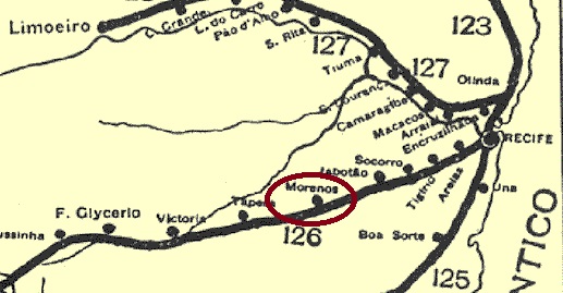
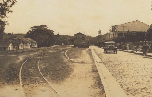
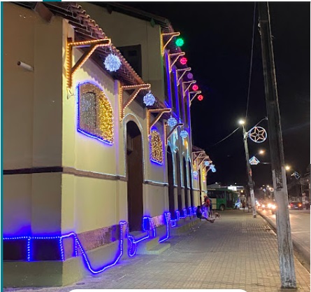
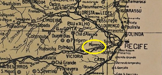
Moreno railway station was opened in August 1885 by the railway company E. F. Recife a Caruaru (also known as Central de Pernambuco) on the north bank of the Jaboatão River in the municipality of the same name. It was located 30 km west of the provincial capital Recife. The railway line was transferred to Great Western in 1904 and to Rede Ferroviária do Nordeste in 1950. From 1975 until its closure in 1996, it belonged to Rede Ferroviária Federal S.A. (estacoesferroviarias.com.br). Today, the tracks are still in place, the station building has been restored, and the area is mainly used as a park and market square.
Around 1930 (As Ferrovias do Brasil, by J. E. Gerodetti and C. Cornejo, São Paulo, 2005)In January 2025 (photo: Lucas Silva, on Google Maps)
The area around the station became a district in March 1920 and a municipality in September 1928. Since December 1938, the spelling has been Moreno. This was the name of two brothers from Portugal who first owned the land. The Engenho Morenos was also built there.
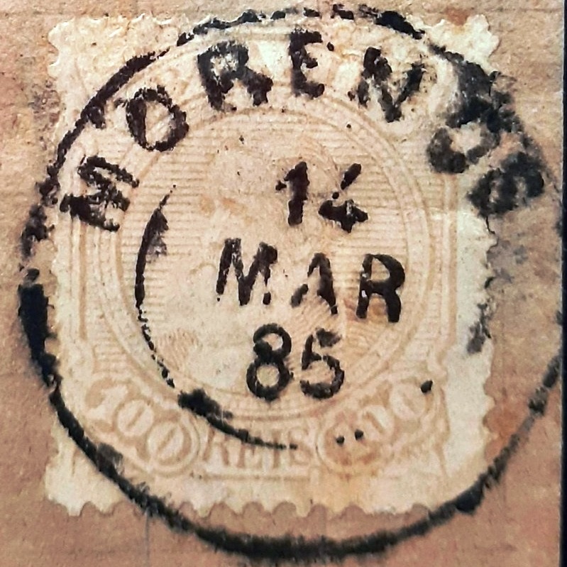
According to the 1889 Post Bulletin (Boletim Postal), there had been a post office at the station since August of that year. The only imperial postmark to date is MPE-0400a (illustration by Felipe Piccinini). However, the date 1885 is puzzling. Is it a dating error, or could it be that an agency was in operation before the railway line was built?
MPE-0400a (FP) 1885?Arthur D. Ribeiro: Estado de Pernambuco, 1924
Andere Schreibweise: Moreno (1938)
Der Bahnhof Morenos wurde im August 1885 von der Eisenbahngesellschaft E. F. Recife a Caruaru (auch Central de Pernambuco genannt) am Nordufer des Jaboatão im gleichnamigen Munizip eröffnet. Er lag 30 km westlich der Provinzhauptstadt Recife. Die Bahnlinie wechselte 1904 zur Great Western und 1950 zur Rede Ferroviária do Nordeste. Von 1975 bis zur Stilllegung im Jahr 1996 gehörte sie der Rede Ferroviária Federal S.A. (estacoesferroviarias.com.br). Heute sind die Gleise noch vorhanden, das Bahnhofsgebäude wurde restauriert und das Areal wird überwiegend als Park- und Marktplatz genutzt.
Um 1930 (As Ferrovias do Brasil, von J. E. Gerodetti und C. Cornejo, São Paulo, 2005)Im Januar 2025 (Foto: Lucas Silva, auf Google Maps).
Das Gebiet um den Bahnhof wurde im März 1920 zum Distrito und im September 1928 zum Municipio. Seit Dezember 1938 gilt die Schreibweise Moreno. So hießen zwei Brüder aus Portugal, die das Land erstmals besaßen. Dort wurde auch die Fazenda Morenos gebaut.
Wie aus dem Postbulletin (Boletim Postal) von 1889 hervorgeht, gab es am Bahnhof seit August desselben Jahres ein Postamt. Der bisher einzige kaiserliche Poststempel ist MPE-0400a (Abbildung von Felipe Piccinini). Das Datum 1885 bereitet jedoch Kopfzerbrechen. Handelt es sich um einen Datierungsfehler oder könnte es sein, dass eine Agentur vor der Errichtung der Bahnlinie in Betrieb war?
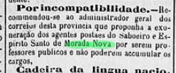
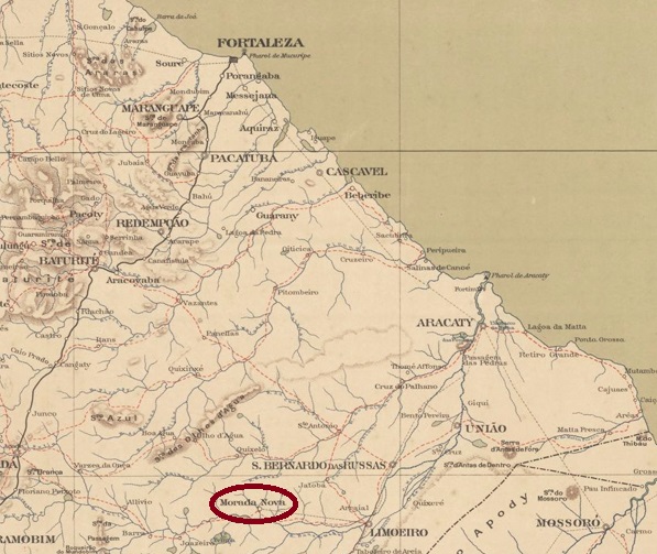
The Freguesia do Divino Espírito Santo de Morada Nova existed since March 1842 and belonged to the Vila de São Bernardo das Russas. It was located on the north bank of the Banabuiú, 170 kilometres south of the provincial capital Fortaleza. In August 1876, it became a vila and finally a city in November 1925.
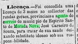
A local post office is mentioned in the regional press between 1881 and 1883.
Cearense, 23.08.1881Cearense, 23.10.1883
As it is not listed in either the imperial postal guide (Guia Postal do Império, Rio de Janeiro, 1880) or the directory of imperial post offices (Tabella das Agencias do Correio do Imperio, Rio de Janeiro, 1885), it must have been in operation in a period between 1879 and 1884.
To date, no imperial postmark from Morada Nova in the province of Ceará has been found.
Google Maps
A Freguesia do Divino Espírito Santo de Morada Nova existia desde março de 1842 e pertencia à Vila de São Bernardo das Russas. Situava-se na margem norte do rio Banabuiú, 170 quilômetros ao sul da capital do estado, Fortaleza. Em agosto de 1876, tornou-se vila e, em novembro de 1925, finalmente cidade.
Uma agência postal local é mencionada na imprensa regional entre 1881 e 1883.
Cearense, 23.08.1881Cearense, 23.10.1883
Como ela não consta nem no Guia Postal do Império (Rio de Janeiro, 1880) nem no Tabela das Agências do Correio do Império (Rio de Janeiro, 1885), deve ter funcionado num período entre 1879 e 1884.
Até o momento, também não foi encontrado nenhum carimbo postal imperial de Morada Nova, na província do Ceará.
Sociedade Geologica e Mineralogica, 1910
Die Freguesia do Divino Espírito Santo de Morada Nova bestand seit März 1842 und gehörte zur Vila de São Bernardo das Russas. Sie lag am Nordufer des Banabuiú, 170 Kilometer südlich der Provinzhauptstadt Fortaleza. Im August 1876 wurde sie zur Vila und im November 1925 schließlich zur Stadt.
Ein lokales Postamt wird zwischen 1881 und 1883 in der regionalen Presse erwähnt:
Cearense, 23.08.1881Cearense, 23.10.1883
Da es weder im kaiserlichen Postführer (Guia Postal do Império, Rio de Janeiro, 1880) noch im Verzeichnis der kaiserlichen Postämter (Tabella das Agencias do Correio do Imperio, Rio de Janeiro, 1885) aufgeführt wird, muss es in einem Zeitraum zwischen 1879 und 1884 in Betrieb gewesen sein.
Bisher wurde auch kein kaiserlicher Poststempel aus Morada Nova in der Provinz Ceará gefunden.
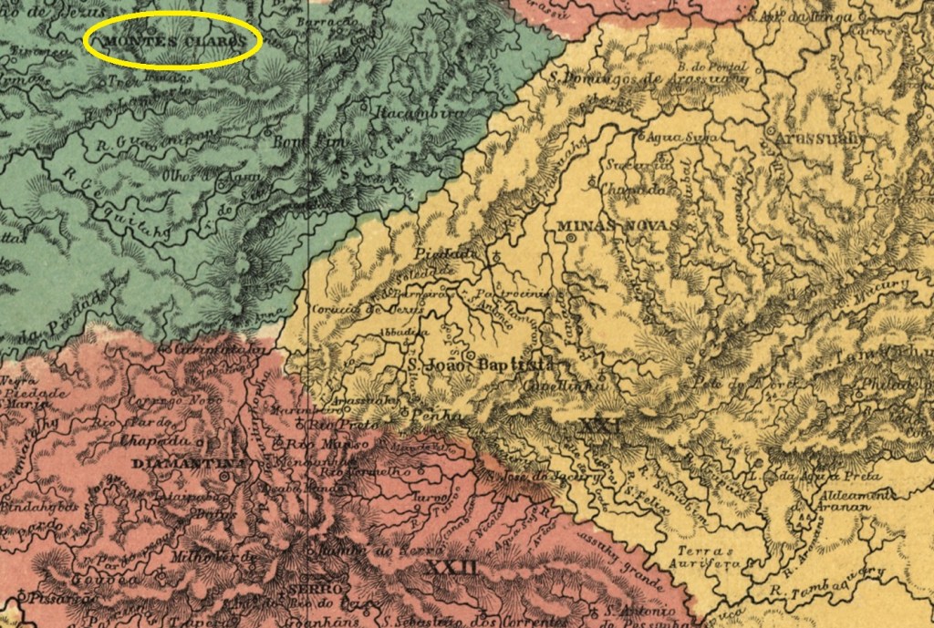
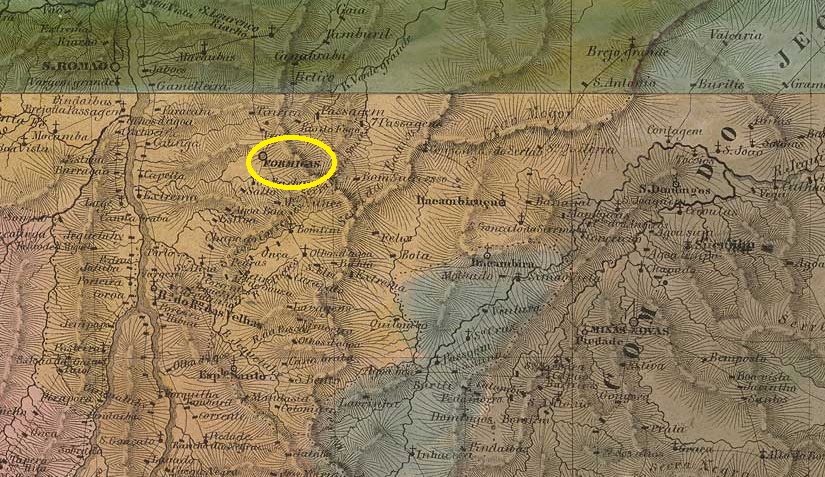
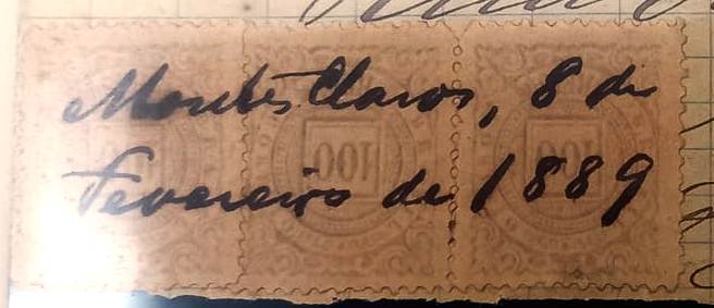
The chapel of N. Sra. da Conceição e São José de Montes Claros de Formigas was founded in June 1769 on the east bank of the Rio do Vieira, a tributary of the left bank of the Verde Grande in the district of Vila do Principe (now Serro), more than 500 km north of the future provincial capital Ouro Preto. The village grew rapidly and was elevated to vila status in October 1831 and to town status in July 1857. Montes Claros de Formigas means light anthills and refers to the calcareous hilltops without vegetation in the region.
The Brazilian statistical agency IBGE wrote in 1959 about the existence of “postal services” (Serviço de Correios) in the locality from December 1832. These must have taken the form of postal relay work, as the local post office did not come into existence until October 1833, as can be read both by Nova Monteiro in Administrações e Agencias Postaes do Brasil Imperio (Brasil Filatelico/RJ, 1934-5; Reprint SPP 1994-1999) and in the postal report (Relatorio Postal) for 1887. Paula Sobrinho reports in his História Postal de Minas Gerais (Belo Horizonte, 1997) an agency creation in June 1853; however, this may be a reopening.
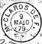
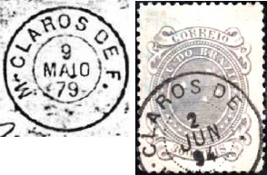
The earliest postmarks bear the simple inscription V. DE FORMIGAS (see VMG-3780). Afterwards, the stamps were often cancelled by hand:
1860 (Fig. R. Koester, in Carimbologia XXVII)1888 (Fig. Koester)1889 (Collection Fuad Ferreira Fo.)
There was also a double-circle postmark, which lost its last letters over time, as shown by the examples of MMG-3600a (fig. Koester-Internet):
MMG-3600a (RK-EB) 1879-1901
Koester (op. cit.) also showed a mute postmark from there:
1879 (RK)Villiers de l’Ile Adam: Carta (…) da Provincia de Minas Geraes, 1849
Ver também Vila de Formigas (VMG-3870)
A capela de N. Sra. da Conceição e São José de Montes Claros de Formigas foi fundada em junho de 1769 na margem leste do Rio do Vieira, tributário da margem esquerda do Verde Grande, no distrito de Vila do Príncipe (atual Serro), mais de 500 km ao norte da futura capital provincial Ouro Preto. A localidade cresceu rapidamente e foi elevada à condição de vila em outubro de 1831 e à cidade em julho de 1857. O nome Montes Claros de Formigas refere-se aos topos de colinas calcárias sem vegetação na região.
O IBGE escreveu em 1959 sobre a existência de “serviço de correios” na localidade a partir de dezembro de 1832. Este deve ter sido através de estafetas, uma vez que a agência local só foi criada em outubro de 1833, como pode ser lido tanto por Nova Monteiro em Administrações e Agências Postais do Brasil Império (Brasil Filatelico/RJ, 1934-5; Reprint SPP 1994-1999) quanto no Relatorio Postal de 1887. Paula Sobrinho em sua História Postal de Minas Gerais (Belo Horizonte, 1997) relata a criação de uma agência em junho de 1853; no entanto, isto pode ser uma reabertura.
Os primeiros carimbos postais ostentam a simples inscrição V. DE FORMIGAS (siehe VMG-3780). Depois disso, os selos eram frequentemente obliterados à mão:
1860 (fig. R. Koester, em Carimbologia XXVII)1888 (fig. Koester)1889 (coleção Fuad Ferreira Fo.)
Havia também um carimbo postal com círculo duplo, que com o tempo perdeu as últimas letras, como mostram os exemplos de MMG-3600a (fig. Koester-Internet):
MMG-3600a (RK-EB) 1879-1901
Koester (op. cit.) também mostrou um carimbo postal mudo de lá:
1879 (RK)Provincia de Minas Geraes, 1873
Siehe auch Vila de Formigas (VMG-3870)
Die Kapelle von N. Sra. da Conceição e São José de Montes Claros de Formigas wurde im Juni 1769 am Ostufer vom Rio do Vieira, einem Zufluss der linken Seite des Verde Grande in der Gemarkung der Vila do Principe (heute Serro), über 500 km nördlich der späteren Provinzhauptstadt Ouro Preto entfernt. Der Ort wuchs schnell und wurde im Oktober 1831 zur Vila und im Juli 1857 zur Stadt erhoben. Montes Claros de Formigas bedeutet helle Ameisenhaufen und weist auf die kalkhaltigen Bergkuppen ohne Vegetation in der Region hin.
Die brasilianische Statistikbehörde IBGE schrieb 1959 über das Vorhandensein von „Postdiensten“ (Serviço de Corrreios) vor Ort ab Dezember 1832. Diese dürfen durch Poststafetten stattgefunden haben, denn das örtliche Postamt entstand erst im Oktober 1833, was sowohl bei Nova Monteiro in Administrações e Agencias Postaes do Brasil Imperio (Brasil Filatelico/RJ, 1934-5; Reprint SPP 1994-1999) als auch im Postbericht (Relatorio Postal) für 1887 zu lesen ist. Paula Sobrinho berichtet in seiner História Postal de Minas Gerais (Belo Horizonte, 1997) über eine Agenturentstehung im Juni 1853; dies mag aber eine Wiedereröffnung sein.
Die frühesten Poststempel tragen die einfache Inschrift V. DE FORMIGAS (siehe VMG-3870). Danach wurden die Briefmarken oft per Hand entwertet:
1860 (Abb. R. Koester, in Carimbologia XXVII)1888 (Abb. Koester)1889 (Samml. Fuad Ferreira Fo.)
Es gab auch einen Poststempel in Doppelkreis, der im Lauf der Zeit die letzten Buchstaben verlor, wie die Beispiele von MMG-3600a (Abb. Koester-Internet) zeigen:
MMG-3600a (RK-EB) 1879-1901
Koester (op. cit.) zeigte auch einen stummen Poststempel von dort:
Villiers de l’Ile Adam: Carta (…) da Provincia de São Paulo, 1847
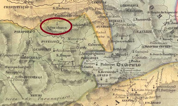
Other names: N. Sra. do Patrocinio do Capivari de Cima
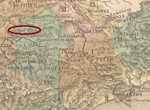
See also Agua Choca (ASP-1820)
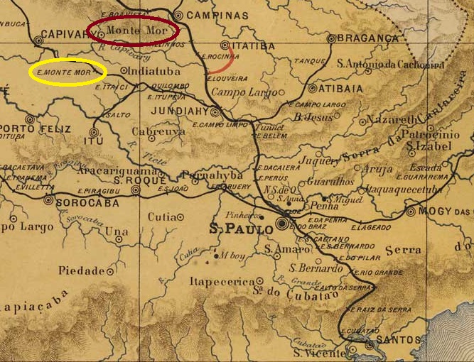
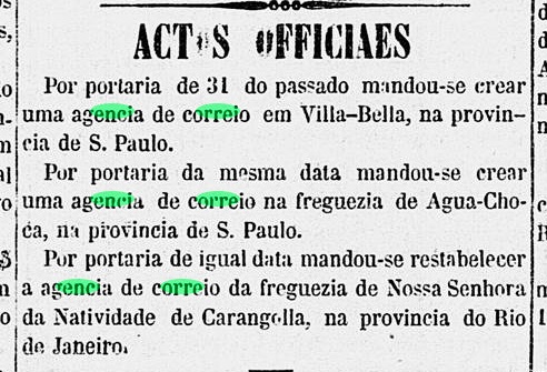
Around 1829, the settlement of N. Sra. do Patrocínio do Capivari de Cima was established, situated on the northern bank of the Capivari River, 120 km northwest of the future provincial capital São Paulo. In August 1832, the place was elevated to a freguesia with the strange name of Agua Choca (Rotten Water), which belonged to the Município of Itu. It was not until March 1871 that the name was changed again, this time as Vila of Monte-Mor (Bigger Mountain).
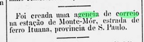
Two years of origin were found for the local post office still under the local name Agua Choca. Firstly in 1854, as found out by philatelist Mario Celso Orsi Jr. Then in March 1865, as reported by the Rio press:
Correio Mercantil/RJ, 02.04.1865
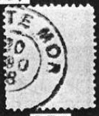
The only imperial postmark with Monte-Mor to date is MSP-0825a (Fig. Koester, in Carimbologia XXVII):
MSP-0825a (RK) 1888
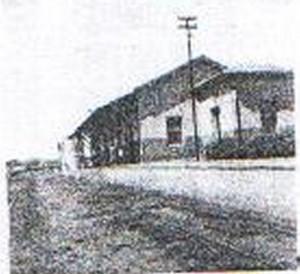
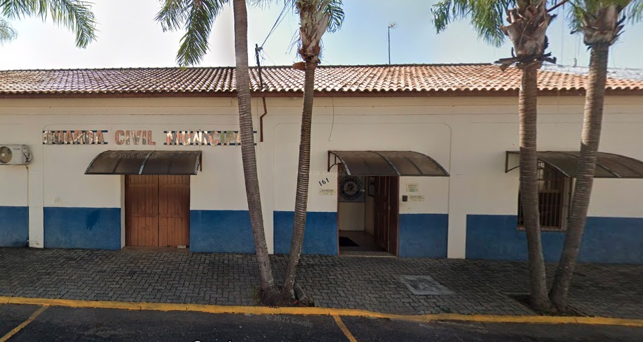
The Monte-Mor railway station was opened in 1875 by the railway company Cia. Ytuana (Piracicaba branch). The railway line was transferred to Cia. União Sorocabana e Ytuana in 1892 and to Sorocabana Railway in 1907. In 1919, it was finally transferred to E.F. Sorocabana. From 1971 until its closure around 1990, it belonged to the FEPASA consortium (estacoesferroviarias.com.br). In July 1900, the station was renamed Elias Fausto, after a director of Ytuana. From November 1925, it was in the district of Elias Fausto and, from November 1944, in the municipality of the same name. Today, the tracks have disappeared, and the station building was supposed to house a retirement home after renovation, but in fact it is now home to the civil police.
In 1956 (Fig. IBGE)In May 2025 (Fig. Google Street View)
As the station was located 15 km southwest of Vila de Monte-Mor, it was given its own post office in December 1884, as announced by the Rio press:
O Paiz/RJ, 14 December 1884
No imperial postmark from the station post office has been found to date.
J.M. Ribeiro Lisboa: Provincia de São Paulo, 1884
Outros nomes: Capivary de Cima
Veja também Agua Choca (ASP-1820)
Por volta de 1829, fundou-se o povoado de N. Sra. do Patrocínio do Capivari de Cima, situado na margem norte do Rio Capivari, 120 km a noroeste da futura capital provincial São Paulo. Em agosto de 1832, o local foi elevado a uma freguesia com o estranho nome de Agua Choca e pertencia ao Município de Itu. Foi só em março de 1871 que o nome foi mudado novamente, desta vez como Vila de Monte-Mor.
Foram encontrados dois anos de origem para os correios locais, ainda como Agua Choca. Primeiro em 1854, conforme comunicado pelo filatelista Mario Celso Orsi Jr. Depois, em março de 1865, como noticiado pela imprensa carioca:
Correio Mercantil/RJ, 02.04.1865
O único carimbo postal imperial com Monte-Mor até agora é o MSP-0825a (fig. Koester, em Carimbologia XXVII):
MSP-0825a (RK) 1888
A estação ferroviária de Monte-Mor foi inaugurada em 1875 pela companhia ferroviária Cia. Ytuana (Ramal de Piracicaba). A linha ferroviária passou para a Cia. União Sorocabana e Ytuana em 1892 e para a Sorocabana Railway em 1907. Em 1919, passou finalmente para a E.F. Sorocabana. De 1971 até ao encerramento em 1990, pertenceu ao consórcio FEPASA (estacoesferroviarias.com.br). Em julho de 1900, a estação foi renomeada para Elias Fausto, em homenagem a um diretor da Ytuana. A partir de novembro de 1925, ela passou a pertencer ao distrito de Elias Fausto e, desde novembro de 1944, ao município de mesmo nome. Hoje, os trilhos desapareceram e o prédio da estação deveria abrigar um asilo após a reforma, mas, na verdade, ele abriga a polícia civil.
Em 1956 (imagem: IBGE)Em maio de 2025 (imagem: Google Street View)
Como a estação ficava a 15 km a sudoeste da Vila de Monte-Mor, ela ganhou uma agência dos correios própria em dezembro de 1884, conforme divulgado pela imprensa do Rio:
O Paiz/RJ, 14/12/1884
Até o momento, não foi encontrado nenhum carimbo postal imperial da agência postal da estação.
Atlas do Imperio do Brasil, 1868
Andere Namen: N. Sra. do Patrocinio do Capivari de Cima
Siehe auch Agua Choca (ASP-1820)
Um 1829 entstand die Siedlung von N. Sra. do Patrocínio do Capivari de Cima, die am Nordufer des Flusses Capivari lag, 120 km nordwestlich der künftigen Provinzhauptstadt São Paulo entfernt. Im August 1832 wurde der Ort zu einer Freguesia erhoben, die den merkwürdigen Namen Agua Choca (Verfaultes Wasser) trug und dem Município von Itu angehörte. Erst im März 1871 wurde der Name wieder geändert, diesmal als Vila von Monte-Mor (Großer Berg).
Zwei Entstehungsjahre wurden fürs örtliche Postamt unter dem Ortsnamen Agua Choca gefunden. Erstmals 1854, wie vom Philatelisten Mario Celso Orsi Jr. ermittelt. Dann im März 1865, wie die Presse aus Rio mitteilte:
Correio Mercantil/RJ, 02.04.1865
Der bisher einzige Poststempel mit Monte-Mor ist MSP-0825a (Abb. Koester, in Carimbologia XXVII):
MSP-0825a (RK) 1888
Der Bahnhof Monte-Mor wurde im Jahr 1875 von der Eisenbahngesellschaft Cia. Ytuana (Piracicaba-Zweig) eröffnet. Die Bahnlinie ging 1892 an die Cia. União Sorocabana e Ytuana über und 1907 an die Sorocabana Railway. 1919 ging sie schließlich an die E.F. Sorocabana über. Von 1971 bis zur Stilllegung um 1990 gehörte sie dem Konsortium FEPASA (estacoesferroviarias.com.br). Im Juli 1900 wurde der Bahnhof in Elias Fausto umbenannt, nach einem Direktor der Ytuana. Ab November 1925 lag er im Distrikt Elias Fausto und seit November 1944 im gleichnamigen Município. Heute sind die Gleise verschwunden und das Bahnhofsgebäude sollte nach der Renovierung einen Altersheim beherbergen, tatsächlich ist dort die Zivilpolizei untergebracht.
Im Jahr 1956 (Abb. IBGE)Im Mai 2025 (Abb. Google Street View)
Da der Bahnhof 15 km südwestlich der Vila de Monte-Mor lag, erhielt er im Dezember 1884 ein eigenes Postamt, wie die Presse aus Rio bekannt gab:
O Paiz/RJ, 14.12.1884
Bisher konnte kein kaiserlicher Poststempel aus dem Bahnhofspostamt gefunden werden.
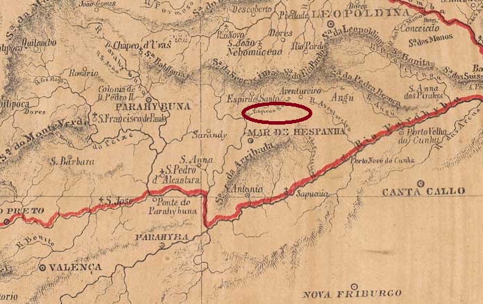
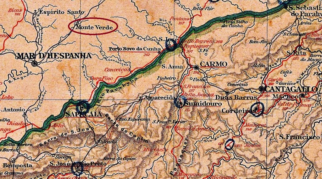
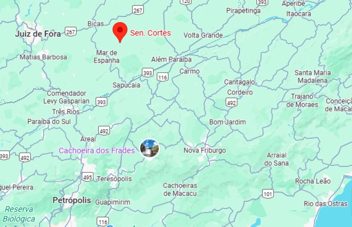
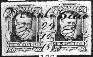
The Freguesia de São Sebastião do Monte Verde existed since October 1881, belonged to the Municipality of Mar de Espanha and was located 2.80 km south of the provincial capital Ouro Preto. In December 1943, it was assigned to the district of Senador Cortes, which has been an independent municipality since December 1962.
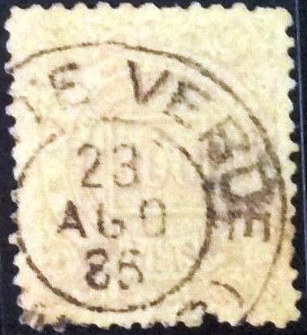
Paula Sobrinho (História Postal de Minas Gerais, Belo Horizonte, 1997) and R. Koester (Carimbologia XXVII) agree that there has also been a post office there since October 1881. The imperial postmark for this is MMG-1640a (image from the internet):
MMG-1640a (EB) 1885Almanak Laemmert, 1892
Outros nomes: Senador Cortes (1943)
A Freguesia de São Sebastião do Monte Verde existia desde outubro de 1881, pertencia ao Município de Mar de Espanha e ficava a 2,80 km ao sul da capital provincial, Ouro Preto. Em dezembro de 1943, foi incorporada ao distrito de Senador Cortes, que desde dezembro de 1962 é um município independente.
Paula Sobrinho (História Postal de Minas Gerais, Belo Horizonte, 1997) e R. Koester (Carimbologia XXVII) concordam que havia uma agência dos correios no local desde outubro de 1881. O carimbo postal imperial é MMG-1640a (figura da Internet):
MMG-1640a (EB) 1885Google Maps
Andere Namen: Senador Cortes (1943)
Die Freguesia de São Sebastião do Monte Verde bestand seit Oktober 1881, gehörte zum Municipio de Mar de Espanha und lag 2.80 km südlich der Provinzhauptstadt Ouro Preto. Im Dezember 1943 wurde sie dem Distrikt Senador Cortes zugeordnet, der seit Dezember 1962 ein eigenständiger Munizip ist.
Paula Sobrinho (História Postal de Minas Gerais, Belo Horizonte, 1997) und R. Koester (Carimbologia XXVII) sind sich einig, dass es dort auch seit Oktober 1881 ein Postamt gab. Der kaiserliche Poststempel davon ist MMG-1640a (Abb. aus dem Internet):
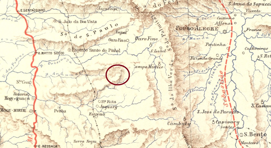
The official history of this town began in March 1849 with the construction of the Nossa Senhora da Conceição da Medalha Milagrosa de Jaboticabal chapel on the provincial border with São Paulo, 530 kilometres southwest of the capital Ouro Preto. According to local legend, the neighbouring Morro Pelado (Bald Mountain) was also called Monte Silhão because it was shaped like a saddle. But the missionaries turned it into Sião (Sion) …
Mount Sião, July 1925 (Photo: Alexandre Marangoni, on Google Maps)
Be that as it may, Monte Sião became a district of Vila de Ouro Fino in April 1854, a Freguesia de Nossa Senhora da Conceição de Monte Sião in December 1874 and an independent municipality in November 1936.
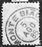
As can be seen from the postal report (Relatorio dos Correios) for the year 1886, there had been a post office there since July 1881. The stamps were initially cancelled by hand, as shown in the picture from R. Koester’s Carimbologia XXVII:
1883 (RK)
The oldest postmark is MMG-1635a, also illustrated in Koester (op. cit.):
MMG-1635a (RK) 1885
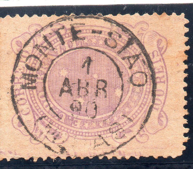
Towards the end of the century, MMG-1635b also appeared (illustration from the internet):
MMG-1635b (EB) 1890Estrada de Ferro Central do Brasil, 1890
Outros nomes: Morro Pelado, Jaboticabal
A história oficial desta localidade começou em março de 1849 com a construção da capela Nossa Senhora da Conceição da Medalha Milagrosa de Jaboticabal, na fronteira com o estado de São Paulo, 530 quilômetros a sudoeste da capital Ouro Preto. Segundo uma lenda local, o vizinho Morro Pelado também era chamado de Monte Silhão, por ter a forma de uma sela. Mas os missionários teriam transformado esse nome em Sião …
Seja como for, Monte Sião tornou-se um distrito da Vila de Ouro Fino em abril de 1854, uma Freguesia de Nossa Senhora da Conceição de Monte Sião em dezembro de 1874 e um município independente em novembro de 1936.
Conforme consta no Relatório dos Correios de 1886, havia uma agência postal no local desde julho de 1881. Inicialmente, os selos eram carimbados à mão, como mostra a imagem de R. Koester em Carimbologia XXVII:
1883 (RK)
O carimbo postal mais antigo é o MMG-1635a, também ilustrado em Koester (op. cit.):
MMG-1635a (RK) 1885
No final do século, surgiu também o MMG-1635b (imagem da Internet):
MMG-1635b (EB) 1890Google Maps
Andere Namen: Morro Pelado, Jaboticabal
Die offizielle Geschichte dieser Ortschaft begann im März 1849 mit dem Bau der Kapelle Nossa Senhora da Conceição da Medalha Milagrosa de Jaboticabal an der Provinzgrenze zu São Paulo, 530 Kilometer südwestlich der Hauptstadt Ouro Preto. Einer lokalen Legende zufolge hieß der benachbarte Morro Pelado (Kahlberg) auch Monte Silhão, da er die Form eines Sattels habe. Doch die Missionare hätten daraus Sião (Sion) gemacht …
Der Berg Sião, Juli 1925 (Foto: Alexandre Marangoni, auf Google Maps)
Wie dem auch sei, Monte Sião wurde im April 1854 ein Distrikt der Vila de Ouro Fino, im Dezember 1874 eine Freguesia de Nossa Senhora da Conceição de Monte Sião und im November 1936 eine eigenständige Gemeinde.
Wie aus dem Postbericht (Relatorio dos Correios) für das Jahr 1886 hervorgeht, gab es dort seit Juli 1881 ein Postamt. Die Briefmarken wurden zunächst per Hand entwertet, wie das Bild aus R. Koesters Carimbologia XXVII zeigt:
1883 (RK)
Der älteste Poststempel ist MMG-1635a, auch im Koester (op. cit.) abgebildet):
MMG-1635a (RK) 1885
Gegen Ende des Jahrhunderts erschien auch MMG-1635b (Abb. aus dem Internet):
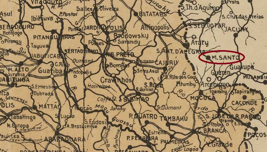
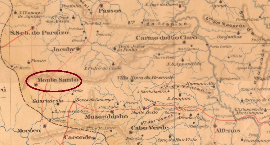
Other names: S. Francisco do Tejuco, Monte Santo de Minas (1948)
Arraial de São Francisco de Paula do Tejuco was first mentioned in documents in 1820. It was located 520 kilometres west of what would later become the provincial capital, Ouro Preto. In June 1858, the town was renamed Freguesia de São Francisco das Chagas do Monte Santo and belonged to Vila de Jacuhy. Monte Santo was designated a vila in November 1890 and a town in May 1892. As there was also a place with this name in Bahia, it was declared the município de Montesanto by decree in December 1943 and renamed Monte Santo de Minas five years later.
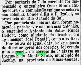
As reported by the Rio press, there had been a post office there since November 1881:
Gazeta de Noticias/RJ, 09.11.1881
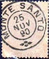
The only imperial postmark to date is MMG-1630a (image from the internet):
MMG-1630a (EB) 1885-1893Estado de Minas Geraes, 1910
Outros nomes: S. Francisco do Tejuco, Monte Santo de Minas (1948)
Desde 1820, o Arraial de São Francisco de Paula do Tejuco era mencionado em documentos. Ele ficava a 520 quilômetros a oeste da futura capital provincial, Ouro Preto. Em junho de 1858, o local foi renomeado para Freguesia de São Francisco das Chagas do Monte Santo e passou a pertencer à Vila de Jacuhy. Monte Santo foi nomeada vila em novembro de 1890 e cidade em maio de 1892. Como esse nome também existia na Bahia, em dezembro de 1943 foi declarado município de Montesanto por decreto e, cinco anos depois, renomeado Monte Santo de Minas.
Conforme divulgado pela imprensa do Rio, havia uma agência dos correios no local desde novembro de 1881:
Gazeta de Notícias/RJ, 09.11.1881
O único carimbo postal imperial conhecido até o momento é o MMG-1630a (figura da internet):
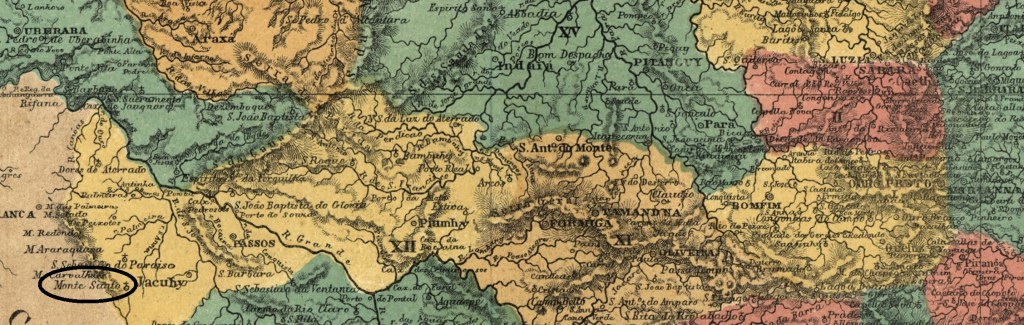
MMG-1630a (EB) 1885-1893Atlas do Imperio do Brasil, 1868
Andere Namen: S. Francisco do Tejuco, Monte Santo de Minas (1948)
Seit 1820 war der Arraial de São Francisco de Paula do Tejuco urkundlich erwähnt. Er lag 520 Kilometer westlich der späteren Provinzhauptstadt Ouro Preto. Im Juni 1858 wurde der Ort in Freguesia de São Francisco das Chagas do Monte Santo umbenannt und gehörte zur Vila de Jacuhy. Monte Santo wurde im November 1890 zur Vila und im Mai 1892 zur Stadt ernannt. Da es diesen Ortsnamen auch in Bahia gab, wurde er im Dezember 1943 per Dekret zum Município de Montesanto erklärt und fünf Jahre später in Monte Santo de Minas umbenannt.
Wie die Presse aus Rio bekannt gab, gab es dort seit November 1881 ein Postamt:
Gazeta de Noticias/RJ, 09.11.1881
Der bisher einzige kaiserliche Poststempel ist MMG-1630a (Abb. aus dem Internet):