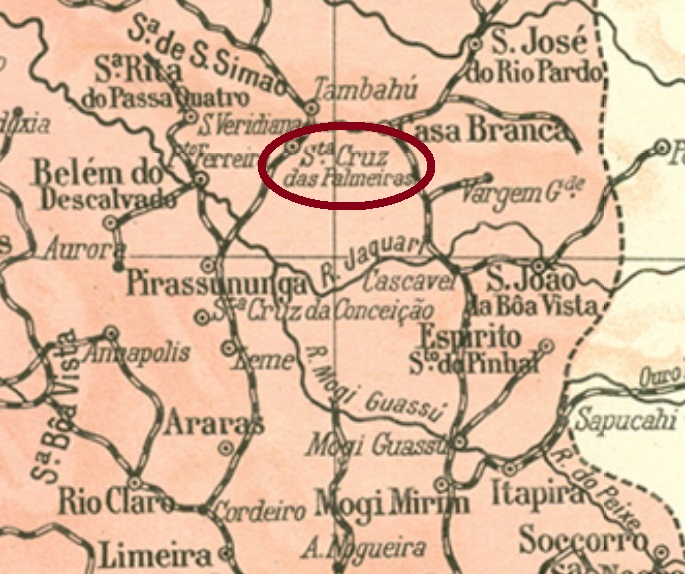
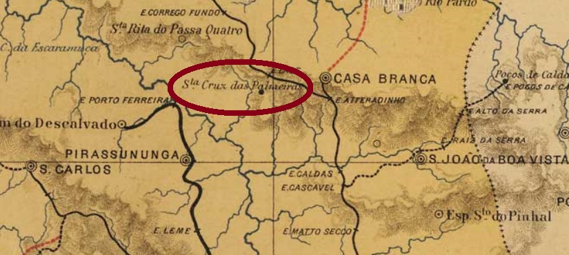
Santa Cruz das Palmeiras was since 1881 a freguesia of Casa Branca, situated round 250 km north of the province capital São Paulo, which in March 1885 ascended to a villa with own municipality and became a town in July 1894.
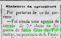
The local post office was created in November 1882, as the Rio press reports:
Diario do Brazil (RJ), November 17, 1882
Two early cancels have been found. SSP-1290a (image from the internet) has a double circle with the inscription STA.CRUZ DAS PALMEIRAS above and a diamond ornament below, whose four sides are open. Dates found within the period 1887-1901. SSP-1290b (image from the internet) has a double circle with the inscription AGEN.DE SANTA CRUZ DAS PALMEIRAS• and dates in the centre, from the period 1889-1892.
J.M. Ribeiro Lisboa: Mappa da Provincia de São Paulo, 1884
Santa Cruz das Palmeiras war seit 1881 eine freguesia von Casa Branca, die ca. 250 nördlich der Provinzhauptstadt lag, im März 1885 zur Villa im eigenen Município aufstieg und im Juli 1894 zur Stadt erhoben wurde.
Das örtliche Postamt entstand im November 1882, wie die Presse aus Rio berichtet:
Diario do Brazil (RJ), 17. November 1882
Zwei frühere Stempel sind bisher vorgekommen. SSP-1290a (Abb. aus dem Internet) hat einen Doppelkreis mit der Inschrift STA.CRUZ DAS PALMEIRAS oben und einem rautenförmigen Ornament unten, dessen Seiten offen sind. Die vorhandenen Daten stammen aus dem Zeitraum 1887-1901. SSP-1290b (Abb. aus dem Internet) hat einen Doppelkreis mit der Inschrift AGEN.DE SANTA CRUZ DAS PALMEIRAS• und Datum in der Mitte. Die vorhandenen Exemplare wurden 1889-1892 gebraucht.
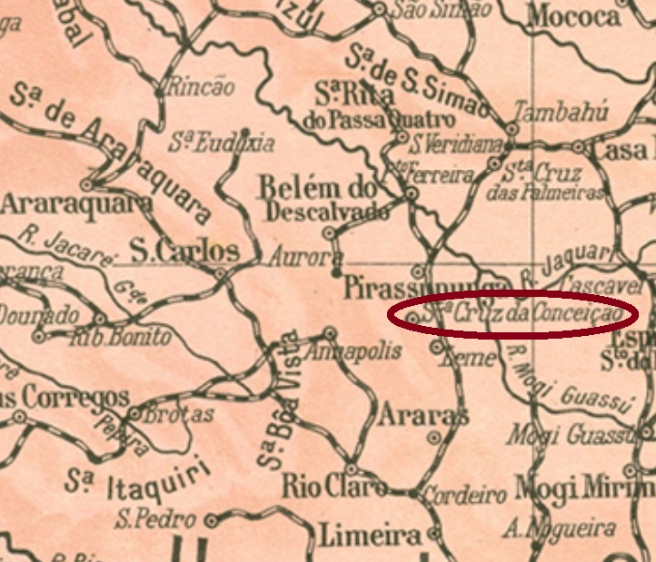
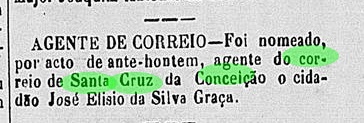
The former Curato of Santa Cruz da Conceição in the muncipality of Pirassununga became a district of Araras in January 1881, but returned to Pirassununga in May 1885. In July 1898 it was elevated to a villa in own municipality, and since December 1906 it is a town.
Only one cancel from the empire is known. SSP-1280a (Coll. FM) imitates a French-type on presenting a double circle with the inscription S.CRUZ DA CONCEIÇAÕ (sic) above and a star within parentheses below, else than dates in the centre. However, this cancel size is bigger than the normal French-type. Dates were found from the period 1889-1907, some copies from around 1890 show two horizontal bars instead of year indication.
Arthur Duarte Ribeiro: Estado de São Paulo, 1924
Der ehemalige Curato Santa Cruz da Conceição im Município von Pirassununga wurde im Januar 1881 ein Distrikt von Araras, aber ging nach Pirassununga im Mai 1885 zurück. Im Juli 1898 stieg er zur Villa im eigenen Município auf, und seit Dezember 1906 ist er eine Stadt.
Laut dem Verzeichnis der kaiserlichen Postämter (Tabella das Agencias do Correio do Imperio) aus 1885 gibt es dort eine Postagentur seit 1881. Im selben Jahr wurde der erste Agent in der regionalen Presse vorgestellt:
Correio Paulistano, 2. Dezember 1881
Nur ein Stempel aus der Kaiserzeit ist überliefert. SSP-1280a (Samml. FM) macht einem „Französischen-typ“ nach: er zeigt einen Doppelkreis mit der Inschrift S.CRUZ DA CONCEIÇAÕ (sic) oben und dem Stern zwischen Klammern unten, dazu Datum in der Mitte. Dennoch ist dieser Stempel größer als der normale „Franzose“. Die Daten wurden für den Zeitraum 1889-1907 gefunden, wobei einige Exemplare von ca. 1890 zwei waagerechte Balken anstatt Jahresangabe zeigen.
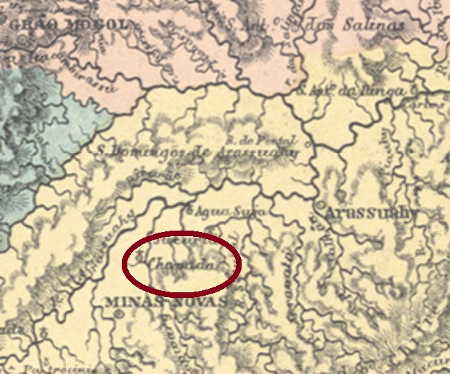
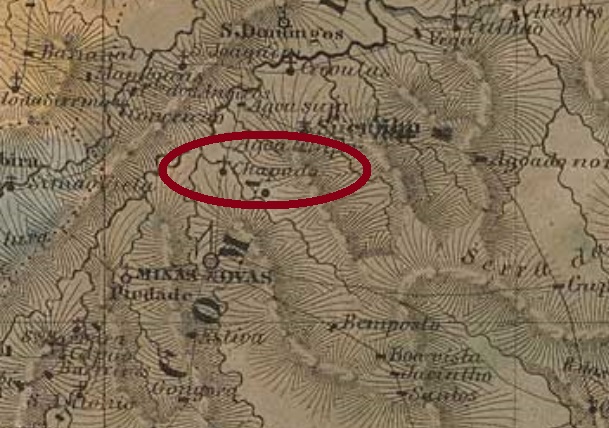
Santa Cruz da Chapada, or simply Chapada, was since May 1850 a district in the municipality of Minas Novas, situated over 600 km north of the province capital Ouro Preto. This status remained until December 1962, when it emancipated as the municipality of Chapada do Norte.
According to Paula Sobrinho (História Postal de Minas Gerais, Belo Horizonte, 1997) the local post office was created on April 9, 1889, but this must be a misprint, for both Nova Monteiro (Administrações e Agencias Postaes do Brasil Imperio, in Brasil Filatelico/RJ, 1934-5; Reprint SPP 1994-1999) and the Imperial Mail Register (Tabella das Agencias do Correio do Imperio) of 1885 state it took place exactly twenty years earlier, i.e. on April 9, 1869. Besides, the sole cancel found by now has dates between 1886 and 1890. SMG-2830b (Coll. José A. Junges) has a double circle with the inscription SANTA CRUZ DA CHAPADA above and a cross-like ornament below, which is formed by four diamonds, with the date in the centre.
Villiers de l’Ile Adam: Carta (…) da Provincia de Minas Geraes, 1849
Santa Cruz da Chapada, oder einfach Chapada, war seit Mai 1850 ein Distrikt im Município von Minas Novas und lag über 600 km nördlich der Provinzhauptstadt Ouro Preto entfernt. Dieser Zustand blieb bis Dezember 1962, als der eigenständige Município von Chapada do Norte gegründet wurde.
Laut Paula Sobrinho (História Postal de Minas Gerais, Belo Horizonte, 1997) entstand das örtliche Postamt am 9. April 1889, aber das muss ein Druckfehler sein, denn sowohl Nova Monteiro (Administrações e Agencias Postaes do Brasil Imperio, in Brasil Filatelico/RJ, 1934-5; Reprint SPP 1994-1999) als auch das Verzeichnis der kaiserlichen Postämter (Tabella das Agencias do Correio do Imperio) von 1885 sind sich darüber einig, dass diese Entstehung genau zwanzig Jahre früher stattgefunden hat, d.h. am 9. April 1869. Außerdem weist das bisher einzige Stempel der Kaiserzeit Daten aus dem Zeitraum 1886-1890 auf. SMG-2830b (Samml. José A. Junges) hat einen Doppelkreis mit der Inschrift SANTA CRUZ DA CHAPADA oben und einem kreuzförmigen Ornament unten, das aus vier kleinen Rauten gebildet wird. Datum in der Mitte.
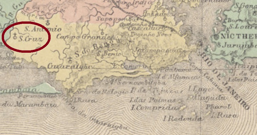
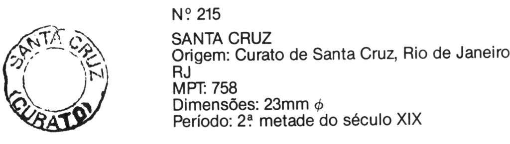
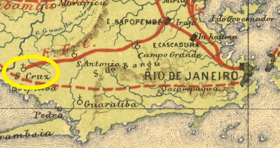
A curato in Portuguese is a settlement provided with an own priest (cura) for its church. The Curato Imperial de Santa Cruz was created in 1833 and has its origins in the royal palace installed for D. João VI after the arrival of the Portuguese court in Rio de Janeiro in 1808. Since 1889 is Santa Cruz a suburb situated over 60 kw west of the capital.
According to Nova Monteiro (Administrações e Agencias Postaes do Brasil Imperio, in Brasil Filatelico/RJ, 1934-5; Reprint SPP 1994-1999), the post office was created in November 1842. Considering that the imperial cancel SMN-0010c (Coll. José A. Junges) was applied without date on a stamp issued in 1866, there must be earlier examples to discover. This one has a double circle, of which the external one is often damaged between the words SANTA and CRUZ above, else than (CURATO) below, with dates until 1899 in the centre:
SMN-0010c (MPT, pg. 56)
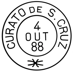
One of the possible predecessors can be SMN-0010b (Coll. Fuad Ferreira Filho): A double circle with the inscription CURATO DE S. CRUZ above and a not quite legible ornament below. Fortunately, a reconstruction of the sole known copy of 1888 was made possible by Claudio Coelho:
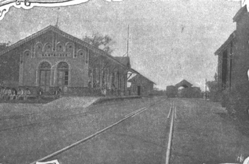
The curato train station was inaugurated on December 2, 1878 by the Estrada de Ferro D. Pedro II railway, as a final line destination. In 1911, the line went until Itaguahy, and in 1914, until Mangaratiba. After the end of the Empire, the rail line passed to the Estrada de Ferro Central do Brasil, and in 1975, to the Rede Ferroviária Federal SA. Since 1997 the line belongs to Supervia (estacoesferroviarias.com.br).
Probably the curato post office was transferred to the train station within the period 1878-1883, for from this year on there was a courier line between the station and Itaguahy:
Gazeta de Noticias, May 17, 1883
As long as no train station postal cancels appear, we can assume that the curato cancels were used in the station after the relocation.
Estrada de Ferro Central do Brazil, 1890
Textaktualisierung vom 27. Juli 2020
Ein Curato auf portugiesisch ist eine Siedlung, die über einen eigenen Pfarrer (Cura) für die Ortskirche verfügt. Der Curato Imperial de Santa Cruz wurde 1833 gegründet, hat aber seinen Ursprung im königlichen Palast für D. João VI, der hastig nach der Ankunft des portugiesischen Hofs 1808 aus einer großen Fazenda hergerichtet wurde. Seit 1889 ist Santa Cruz ein über 60 km entfernter Stadtteil im Westen von Rio de Janeiro.
Laut Nova Monteiro (Administrações e Agencias Postaes do Brasil Imperio, in Brasil Filatelico/RJ, 1934-5; Reprint SPP 1994-1999), wurde das örtliche Postamt im November 1842 eingeweiht. Da der Stempel aus dem Kaiserreich SMN-0010c (Samml. José A. Junges) ohne Datum auf einer Marke zu sehen ist, die erst 1866 ausgegeben wurde, warten bestimmt noch frühere Stempel auf ihre Entdeckung. Dieser hat einen Doppelkreis, wovon der äußere oft einen Bruch zwischen den Worten SANTA und CRUZ oben aufweist. Unten liest man (CURATO), und die Daten (bis 1899) sind in der Mitte:
SMN-0010c (MPT, S. 56)
Ein möglicher Vorgänger wäre SMN-0010b (Samml. Fuad Ferreira Filho): ein Doppelkreis mit der Inschrift CURATO DE S. CRUZ oben und einer nicht ganz lesbaren Verzierung unten. Eine Rekonstruktion des bisher einzigen Exemplars dieses Stempels (aus 1888) wurde freundlicherweise durch Claudio Coelho ermöglicht:
Der Curato-Bahnhof wurde am 2 Dezember 1878 durch die Estrada de Ferro D. Pedro II als Endstation engeweiht. Die Linie wurde noch zweimal verlängert: 1911 nach Itahguahy und 1914 nach Mangaratiba. Nach dem Ende des Kaiserreichs ging die Bahnlinie zur Estrada de Ferro Central do Brasil, und 1975, zur Rede Ferroviária Federal SA. Seit 1997 gehört die Bahnstrecke der Supervia (estacoesferroviarias.com.br).
Wahrscheinlich zog das Curato-Postamt zum Bahnhof irgendwann zwischen 1878 und 1883 um, den im letztgenannten Jahr wurde ein Post-Staffetendienst zwischen dem Curato-Bahnhof und Itaguahy eingeführt:
Gazeta de Noticias, 17. Mai 1883
So lange keine neuen Bahnhofsstempel auftauchen, können wir annehmen, dass die alten Curato-Stempel auch nach dem Umzug zum Bahnhof gebraucht wurden.
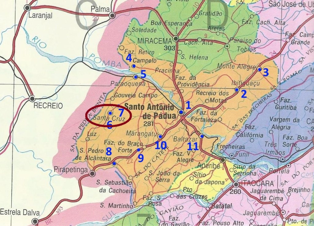
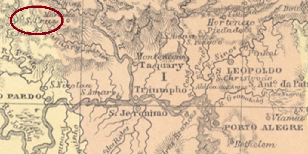
An arraial means in Brazil a small village or popular fair. The Arraial de Santa Cruz de Monte Alegre was founded in January 1882 in the municipality of Santo Antonio de Padua round 250 km northeast from Rio de Janeiro, near the border to Minas Gerais. In May 1892, i.e. already in the republic, it was elevated to a district. Since then, the toponym has changed quite often: in November 1918 to São Pedro de Alcântara, in December 1923 to Santa Cruz de Monte Alegre, in December 1938 back to Santa Cruz, in December 1943 to Ibitinema, and finally in January 1967 back again to Santa Cruz.
According to Paulo Novaes (agenciaspostais.com.br), the post office was created in December 1883 and remained active until “ca. 1899”. Meanwhile there were found two early cancels. SRJ-2290a (Coll. Klerman Lopes) has a double circle with the inscription ARRAIAL DE SẠ CRUZ above and a diamond ornament below, formed by four small diamonds. The sole known example has a date of 1888 in the centre. There is also only one image for the following SRJ-2290b (agenciaspostais.com.br): a double circle with the inscription ARRAIAL DE SẠ CRUZ and an illegible handwritten date in the centre. Since the stamp was issued in 1894, it must have been used in the period 1894-1899.
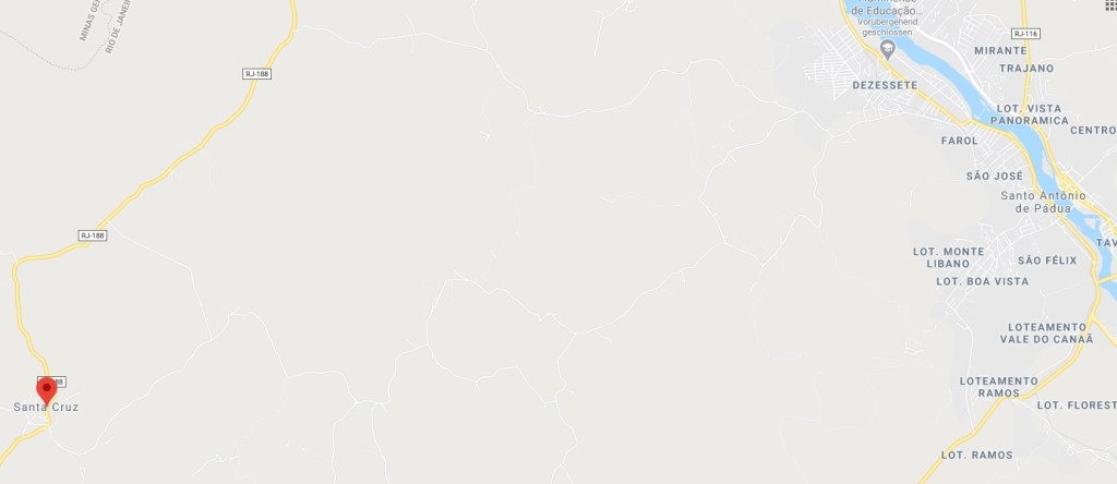
GoogleMaps
Textaktualisierung vom 22. Juli 2020
In Brasilien bezeichnet das Wort Arraial sowohl eine kleine Siedlung als auch ein Volksfest. Der Arraial de Santa Cruz de Monte Alegre wurde im Januar 1882 im Município von Santo Antônio de Pádua gegründet und lag rund 250 km nordöstlich von Rio de Janeiro entfernt, nah an der Grenze zu Minas Gerais. Im Mai 1892, also bereits in der Republik, wurde daraus ein Distrikt. Seitdem wechselte der Ortsname ziemlich oft: im November 1918 zu São Pedro de Alcântara, im Dezember 1923 zu Santa Cruz de Monte Alegre, im Dezember 1938 zurück zu Santa Cruz, im Dezember 1943 zu Ibitinema, und schließlich im Januar 1967 nochmals zurück zu Santa Cruz.
Laut Paulo Novaes (agenciaspostais.com.br) gibt es dort ein Postamt seit Dezember 1883, das bis “ca. 1899” in Betrieb blieb. Inzwischen wurden zwei frühe Stempel gefunden. SRJ-2290a (Samml. Klerman Lopes) hat einen Doppelkreis mit der Inschrift ARRAIAL DE SẠ CRUZ oben und einem rautenförmigen Ornament unten, das aus 4 kleinen Rauten besteht. Das einzige bekannte Exemplar trägt ein Datum aus 1888 in der Mitte. Auch von seinem Nachfolger kennen wir nur eine Abbildung: SRJ-2290b (agenciaspostais.com.br) zeigt einen Doppelkreis mit der Inschrift ARRAIAL DE SẠ CRUZ und einem handgeschriebenen Datum (unleserlich) in der Mitte. Da die Marke 1894 ausgegeben wurde, wird sie im Zeitraum 1894-1899 verwendet worden sein.
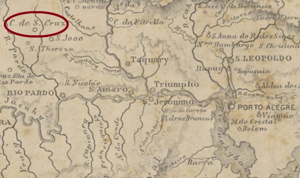
The district of São João de Santa Cruz was founded in January 1859 in the municipality of Rio Pardo, over 150 km west of the province capital Porto Alegre. In March 1877 it was elevated to a villa in own muncipality, which became a town in November 1905. Since December 1944 it is called Santa Cruz do Sul.
According to Nova Monteiro (Administrações e Agencias Postaes do Brasil Imperio, in Brasil Filatelico/RJ, 1934-5; Reprint SPP 1994-1999) the post office was created in September 1864. Two relatively late cancels could be identified. SRS-0390b (Coll. Karlheinz Wittig) occurs in black, blue and carmine and has a double circle with the inscriptions SANTA CRUZ above and a (5) below. The dates in the centre were found for the period 1876-1889. SRS-0390c (Coll. FM) could be already republican, for the existing dates until now are from the period 1893-1908. It also has a double circle, but now the inscriptions are S.CRUZ above an (S.PEDRO DO SUL) below.
For actual information about disambiguation among Santa Cruz cancels see also:
Mappa da Provincia de São Pedro do Rio Grande do Sul, 1877
Der Distrikt von São João de Santa Cruz wurde im Januar 1859 im Município von Rio Pardo gegründet und lag über 150 km westlich von der Provinzhauptstadt Porto Alegre entfernt. Im März 1877 stieg er zur Villa auf und wurde im November 1905 eine Stadt. Seit Dezember 1944 ist es der Município von Santa Cruz do Sul.
Laut Nova Monteiro (Administrações e Agencias Postaes do Brasil Imperio, in Brasil Filatelico/RJ, 1934-5; Reprint SPP 1994-1999) entstand das örtliche Postamt im September 1864. Zwei Stempel aus der Spätzeit des Kaiserreichs konnten dorthin zugeordnet werden. SRS-0390b (Samml. Karlheinz Wittig) erscheint in schwarz, blau und karminrot und hat einen Doppelkreis mit den Inschriften SANTA CRUZ oben und einer (5) unten. Die daten in der Mitte wurden für den Zeitraum 1876-1889 gefunden. SRS-0390c (Samml. FM) könnte bereits republikansich sein, da die bisher vorhandenen Daten aus dem Zeitraum 1893-1908 stammen. Er hat auch einen Doppelkreis, nun ist hier S.CRUZ oben und (S.PEDRO DO SUL) unten zu lesen.
Zum Problemkomplex der Unterscheidung zwischen den Santa Cruz-Stempeln siehe auch:
Mappa dos Estados do Ceará, Rio Grande do Norte e Parahyba, 1910
Text update of August 27, 2020
Other name: Santa Cruz da Ribeira do Trahiry
See also Santa Rita/RN (SRN-0230)
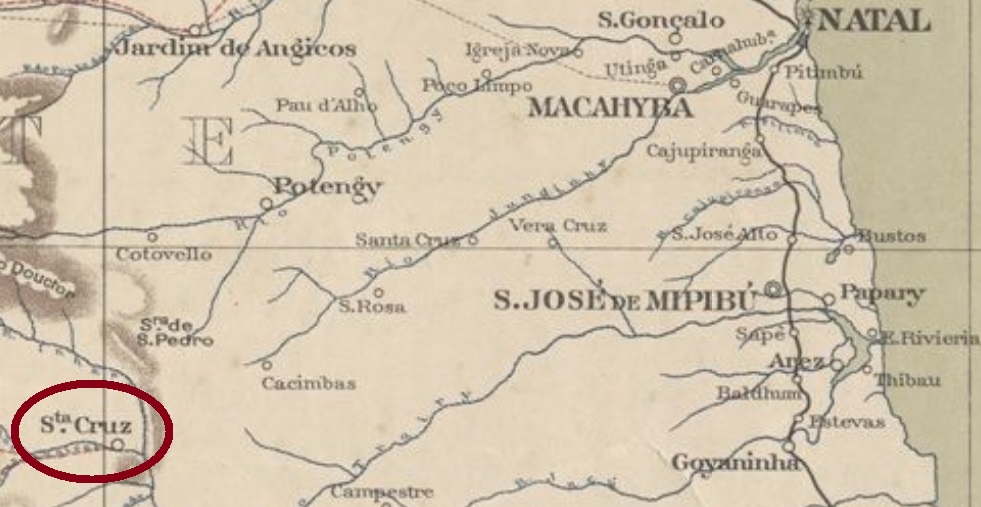
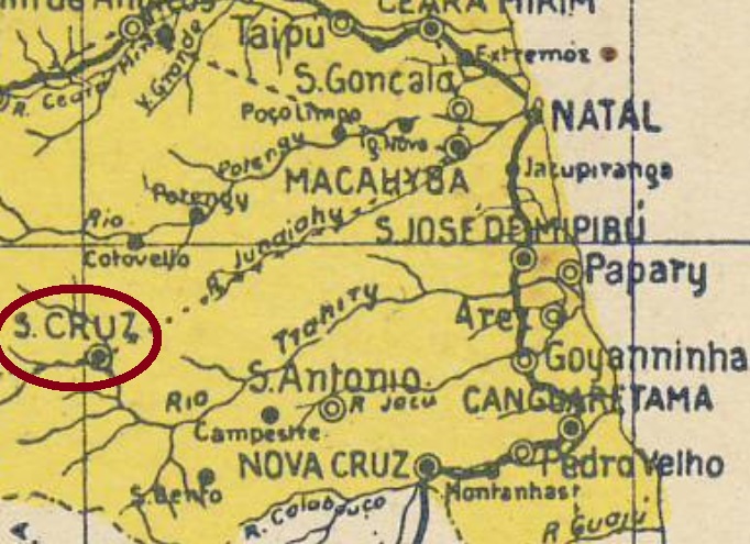
The settlement of Santa Cruz da Ribeira do Trahiry was founded in the freguesia of Santa Rita da Cachoeira, which from 1864 on belonged to municipality of São José de Mipibu, and was situated over 130 km southwest of the province capital Natal. In December 1876 it was elevated to the villa of Trahury in own municipality, and since November 1914 it is the town of Santa Cruz.
According to theImperial Mail Register (Tabella das Agencias do Correio do Imperio) of 1885, which already listed this agency as Santa Cruz, the post office was created in 1874.
For actual information about disambiguation among Santa Cruz cancels see also:
Arthur D. Ribeiro: Mapa do Rio Grande do Norte, 1923
Textaktualisierung vom 27. August 2020
Anderer Name: Santa Cruz da Ribeira do Trahiry
Siehe auch: Santa Rita/RN (SRN-0230)
Die Siedlung Santa Cruz da Ribeira do Trahiry wurde in der Freguesia von Santa Rita da Cachoeira gegründet, als diese dem Município von São José do Mipibu gehörte, und lag über 130 km südwestlich der Provinzhauptstadt Natal entfernt. Im Dezember 1876 stieg sie zur Villa von Trahiry auf, und seit November 1914 heißt die Stadt Santa Cruz.
Das Verzeichnis der kaiserlichen Postämter (Tabella das Agencias do Correio do Imperio) von 1885 listet diese Agentur bereits unter dem Namen Santa Cruz, mit Entstehungsjahr 1874.
Zum Problemkomplex der Unterscheidung zwischen den Santa Cruz-Stempeln siehe auch:
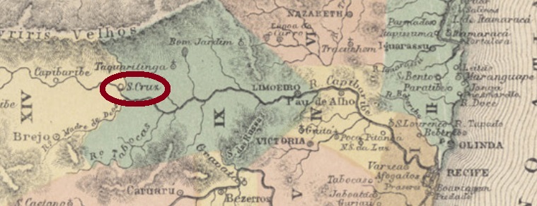
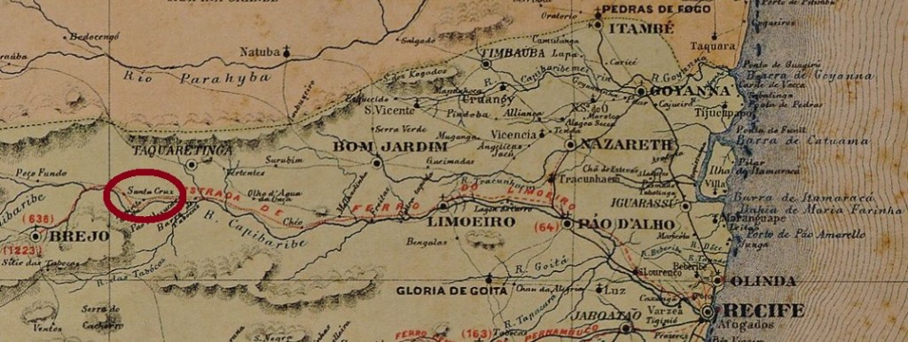
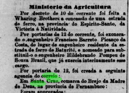
Santa Cruz in Pernambuco was since August 1875 a district of the municipality of Brejo da Madre de Deus, situated around 700 km west of the province capital Recife. In January 1915 it changed to the newly created municipality of Ouricuri. After that the toponym has twice changed: in March 1938 to Vera Cruz, and in December 1943 to Cruz de Malta. Since January 1991 it is the municipality of Santa Cruz.
The post office was created in June 1882, as informed by the provincial press:
Jornal do Recife, June 20, 1882
For actual information about the Santa Cruz cancel disambiguation see also:
Carta Corographica da Provincia de Pernambuco, 1880
Santa Cruz in der Provinz Pernambuco war seit August 1875 ein Distrikt im Município von Brejo da Madre de Deus und lag etwa 700 km westlich von der Hauptstadt Recife entfernt. Im Januar 1915 wurde der Distrikt dem neuen Município von Ouricuri zugeordnet. Danach wechselte der Ortsname zweimal: im März 1938 (zu Vera Cruz) und im Dezember 1943 (zu Cruz de Malta). Seit Januar 1991 ist der alte Name Santa Cruz wieder da, als ein eigenständiger Município.
Das örtliche Postamt ist im Juni 1882 entstanden, wie die Presse berichtet:
Jornal do Recife, 20. Juni 1882
Zum Problemkomplex der Unterscheidung zwischen den Santa Cruz-Stempeln siehe auch:
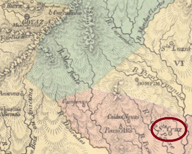
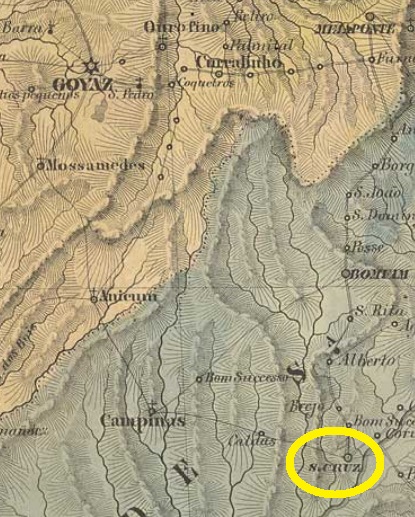
This Santa Cruz in the Goyaz province exists since August 1729. It was founded by gold miners in the Brazilian hinterland, about 300 km southeast of the future province capital Goyaz (today Goiás Velho). In September 1759 it was declared a district and became a Villa in April 1833. After becoming a town in August 1884, it must have passed through a decadence period, for it descended as a district of the municipality of Pires do Rio in March 1938, which switched to the municipality of Corumbalina in December 1943. Only in July 1947 the town status returned, within the actual municipality of Santa Cruz de Goiás.
According to Nova Monteiro (Administrações e Agencias Postaes do Brasil Imperio, in Brasil Filatelico/RJ, 1934-5; Reprint SPP 1994-1999), the local post office was created in March 1829, but given that the Imperial Mail Register (Tabella das Agencias do Correio do Imperio) of 1885 writes 1832 as the starting year, this agency supposedly has been closed in the meantime. It is not quite sure that it remained steadily active after 1832, but there was a mail courier line from Corumbá(GO) to Catalão through Santa Cruz in 1859, and another one between Goyaz and Santa Cruz (six monthly trips) in 1879.
Considering such a long postal history, it is quite deceptive that even the only imperial cancel found for this locality is still of uncertain attribution. SGO-0205a has been probably used from the pre-philatelic period until after 1843, and was already presented by the RHM-catalogue under P-GO-05:
SGO-0205a (CE-RHM P-GO-05)
For actual information about the Santa Cruz cancel disambiguation see also:
Villiers de l’Ile Adam: Carta (…) da Provincia de Goyaz
Diese Santa Cruz in der Provinz Goyaz gibt es seit August 1729. Sie wurde durch Goldgräber gegründet und lag ca. 300 km südöstlich der künftigen Provinzhauptstadt Goyaz (heute Goiás Velho) entfernt. Im September 1759 stieg sie zu einem Distrikt auf, der im April 1833 zu einer Villa wurde. Nach der Ernennung zur Stadt im August 1884 muss Santa Cruz eine Phase der Dekadenz erlebt haben, denn der Ort wurde wieder ein Distrikt des Município von Pires do Rio im März 1938, um im Dezember 1943 zum neu gegründeten Município von Corumbalina zu wechseln. Erst im Juli 1947 kam der Stadtstatus zurück, es entstand dabei der heutige Município von Santa Cruz de Goiás.
Laut Nova Monteiro (Administrações e Agencias Postaes do Brasil Imperio, in Brasil Filatelico/RJ, 1934-5; Reprint SPP 1994-1999) wurde das Postamt im März 1829 gegründet, aber da das Verzeichnis der kaiserlichen Postämter (Tabella das Agencias do Correio do Imperio) aus 1885 das Jahr 1832 dafür angibt, könnte diese Agentur in der Zwischenzeit mal geschlossen gewesen sein. Auch nach 1832 ist es nicht sicher, ob sie ständig in Betrieb war. Dennoch gab es 1859 eine Poststafettenlinie zwischen Corumbá(GO) und Catalão, die durch Santa Cruz ging, und eine weitere 1879 zwischen Goyaz und Santa Cruz (sechsmal im Monat).
Bei solcher langen Betriebszeit ist schon fast enttäuschend festzustellen, dass sogar der einzig gefundene Stempel der Kaiserzeit von Santa Cruz in Goyaz nicht zweifelsfrei zuzuordnen ist. SGO-0205a, vermutlich schon in der Vorphila-Zeit bis nach 1843 benutzt, wurde bereits im RHM-Katalog unter P-GO-05 vorgestellt:
SGO-0205a, (CE-RHM P-GO-05)
Zum Problemkomplex der Unterscheidung zwischen den Santa Cruz-Stempeln siehe auch:
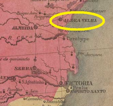
Villiers de l’Ile Adam: Carta (…) da Provincia do Espirito Santo, 1850
Other name: Aldeia Velha
This Santa Cruz was the former Freguesia of Aldeia Velha (= Old Village), established in December 1837 in the municipality of Nova Almeida, situated over 80 km north of the former province capital Villa do Espírito Santo (now Vila Velha). In April 1848 it ascended to a villa in own municipality, named Santa Cruz, which became a town in March 1891. In December 1943 the toponym was changed to the actual Aracruz.
According to Nova Monteiro (Administrações e Agencias Postaes do Brasil Imperio, in Brasil Filatelico/RJ, 1934-5; Reprint SPP 1994-1999), the local post office was created in October 1831. This would mean there is a possible cancel featuring Aldeia Velha, which yet has never appeared. Since Paulo Novaes (agenciaspostais.com.br) lists this agency with creation date “ca. 1856”, it may have been closed in the meantime.
One imperial cancel could be to date safely identified, but it is surely not the earliest one, for it shows using dates between 1886 and 1903. SES-0165b (Coll. José A. Junges) has a double circle with the inscriptions S. CRUZ above and (ESP. SANTO) below, with date in the centre.
For actual information about the Santa Cruz cancel disambiguation see also:
Diese Santa Cruz hieß ursprünglich Freguesia von Aldeia Velha (= Altes Dorf), gegründet im Dezember 1837 im Município von Nova Almeida und über 80 km nördlich der ehemaligen Provinzhauptstadt Villa do Espírito Santo (heute: Vila Velha) gelegen. Im April 1848 wurde sie zu einer eigenständigen Villa unter dem Namen Santa Cruz, die im März 1891 zur Stadt wurde. Im Dezember 1943 wechselte der Ortsnamen zum heutigen Aracruz.
Laut Nova Monteiro (Administrações e Agencias Postaes do Brasil Imperio, in Brasil Filatelico/RJ, 1934-5; Reprint SPP 1994-1999) entstand das örtliche Postamt im Oktober 1831. Dadurch wäre ein Stempel mit Aldeia Velha möglich, der allerdings bisher nicht aufgetaucht ist. Da Paulo Novaes (agenciaspostais.com.br) diese Agentur mit Entstehungsjahr “ca. 1856” auflistet, könnte sie zwischendurch mal geschlossen gewesen sein.
Ein Stempel aus der Kaiserzeit konnte bisher zweifelsfrei hierher zugeordnet werden. Der ist aber sicher nicht der älteste, da die Verwendungsdaten aus den Jahren 1886-1903 stammen. SES-0165b (Samml. José A. Junges) hat einen Doppelkreis mit den Inschriften S. CRUZ oben und (ESP. SANTO) unten, dazu das Datum in der Mitte.
Zum Problemkomplex der Unterscheidung zwischen den Santa Cruz-Stempeln siehe auch: