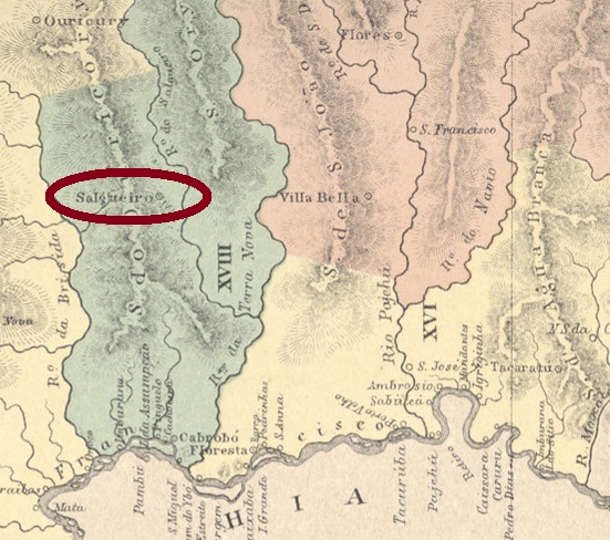
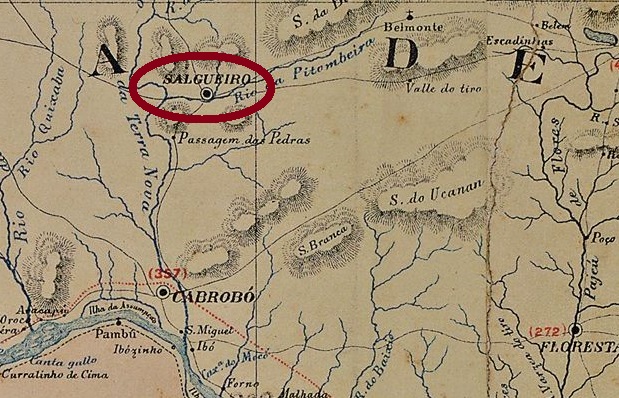
Salgueiro (sometimes written Salgueiros) was since May 1843 a district of the municipality of Cabrobó, situated over 500 km west of the province capital Recife. The name derives probably from the salgueiro tree (Salix sp.), a willow. In April 1864 Salgueiro became a villa with own municipality, and since April 1898 it is a town.
According to Nova Monteiro (Administrações e Agencias Postaes do Brasil Imperio, in Brasil Filatelico/RJ, 1934-5; Reprint SPP 1994-1999), the local post office was created in June 1864, a year which is confirmed by the Imperial Mail Register (Tabella das Agencias do Correio do Imperio) of 1885. Only one imperial cancel is known, which is probably not the earliest one. SPE-0575b (Coll. José A. Junges) is a French-type, with a double circle and the inscription SALGUEIRO above, and the little star in parentheses below. The date, when present, is in the centre. Known exemplars are from 1886.
Carta Corographica de Pernambuco, 1880
Salgueiro (auch Salgueiros geschrieben) war seit Mai 1843 ein Distrikt von Cabrobó und lag über 500 km westlich von der Provinzhauptstadt Recife entfernt. Der Name stammt höchstwahrscheinlich von einem Baum der Familie der Weiden (Salix sp.). Im April 1864 stieg Salgueiro zu einer Villa auf, und seit April 1898 ist es eine Stadt.
Laut Nova Monteiro (Administrações e Agencias Postaes do Brasil Imperio, in Brasil Filatelico/RJ, 1934-5; Reprint SPP 1994-1999) entstand das örtliche Postamt im Juni 1864. Dieses Jahr wird durch das Verzeichnis der kaiserlichen Postämter (Tabella das Agencias do Correio do Imperio) von 1885 bestätigt. Nur ein Stempel aus der Kaiserzeit ist überliefert, dieser dürfte nicht der älteste sein. SPE-0575b (Samml. José A. Junges) ist ein “Französischer-Typ”, er hat einen Doppelkreis mit der Inschrift SALGUEIRO oben und dem typischen Sternchen in Klammern unten. Das Datum, wenn vorhanden, ist in der Mitte. Die vornandenen Exemplare sind aus 1886.
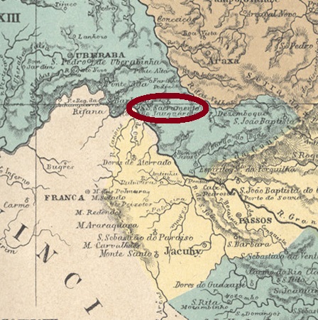
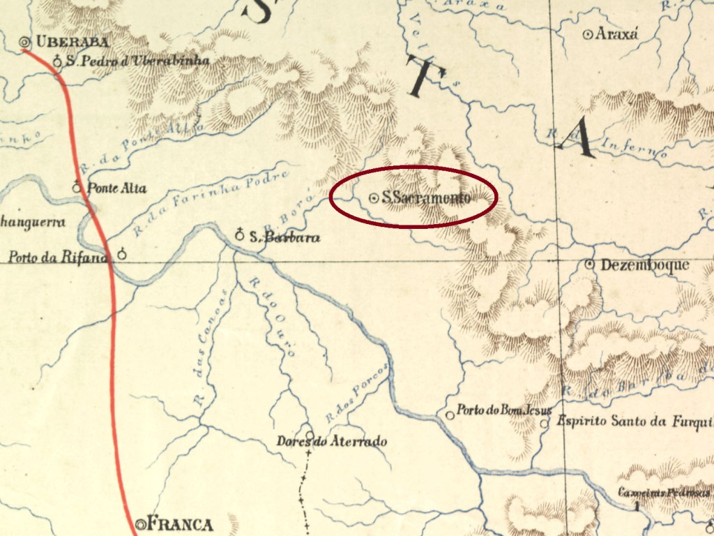
The freguesia of Santissimo Sacramento (= Holiest Sacrament) was founded in July 1857 in the municipality of Araxá, over 500 km west of the province capital Ouro Preto. In September 1870 it was elevated to a villa, and since June 1876 it is the town of Sacramento.
Both Nova Monteiro (Administrações e Agencias Postaes do Brasil Imperio, in Brasil Filatelico/RJ, 1934-5; Reprint SPP 1994-1999) and Paula Sobrinho (História Postal de Minas Gerais, Belo Horizonte, 1997) agree in stating that the post office was created in October 1868. This year is also confirmed by the Imperial Mail Register (Tabella das Agencias do Correio do Imperio) of 1885.
Two imperial cancels are known. SMG-2680a, which was already presented by Paulo Ayres (Catálogo de Carimbos Brasil-Império, S. Paulo, 1937, 1942), is certainly the older one and can be found on objects until at least 1877:
SMG-2680a, Paulo Ayres #1486
It is followed by SMG-2680b (Coll. Dieter Kerkhoff): a double circle with the inscriptions SACRAMENTO above and (MINAS) below. The dates in the centre vary between 1888 and 1899.
EFCB 1890
Die Freguesia von Santissimo Sacramento (= Heiligstes Sakrament) wurde im Juli 1857 im Município von Araxá gegründet und lag über 500 km westlich der Provinzhauptstadt Ouro Preto entfernt. Im September 1870 stieg sie zur Villa auf und heißt seit Juni 1876 Stadt Sacramento.
Nova Monteiro (Administrações e Agencias Postaes do Brasil Imperio, in Brasil Filatelico/RJ, 1934-5; Reprint SPP 1994-1999) und Paula Sobrinho (História Postal de Minas Gerais, Belo Horizonte, 1997) sind sich darüber einig, dass das örtliche Postamt im Oktober 1868 entstanden ist. Diese Jahresangabe wird auch durch das Verzeichnis der kaiserlichen Postämter (Tabella das Agencias do Correio do Imperio) aus 1885 bestätigt.
Zwei Abstempelungen der Kaiserzeit sind überliefert. SMG-2680a, die bereits durch Paulo Ayres (Catálogo de Carimbos Brasil-Império, S. Paulo, 1937, 1942) vorgestellt wurde, ist sicherlich die älteste davon und kommt in Objekten vor, die bis mindestens 1877 datiert sind:
SMG-2680a, Paulo Ayres Nr. 1486
Der Nachfolger, SMG-2680b (Coll. Dieter Kerkhoff), hat einen Doppelkreis mit den Inschriften SACRAMENTO oben und (MINAS) unten. Die Daten in der Mitte pendeln zwischen 1888 und 1899.
Villiers de l’Ile Adam: Carta (…) da Provincia do Rio de Janeiro, 1850
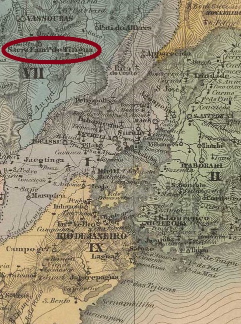
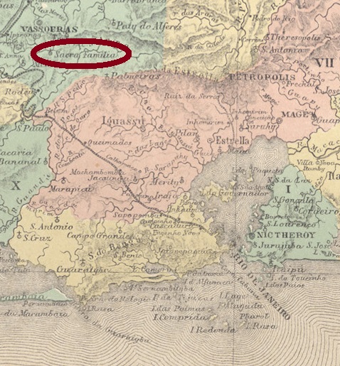
Other names: Sacra Família
Tinguá means top or peak in tupi. Sacra Família do Caminho Novo do Tinguá (= Holy Family of the New Road to Tinguá) was created in 1750 as an independent freguesia situated 107 km northwest of Rio de Janeiro, in a vast area from which many municipalities have their origin. In January 1833 it was degraded to a district of the new villa of Vassouras, and in November 1958 it became a district of Engenheiro Paulo de Frontin, the former Rodeio (RRJ-2155).
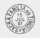
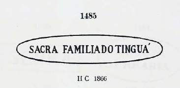
The Imperial Mail Register (Tabella das Agencias do Correio do Imperio) of 1860 lists this post office with creation year 1859, whereas Nova Monteiro (Administrações e Agencias Postaes do Brasil Imperio, in Brasil Filatelico/RJ, 1934-5; Reprint SPP 1994-1999) gives the exact date of January 2, 1860. Two imperial cancels are known: SRJ-2155a, the older one, was used from the beginning until at least 1884, and already presented by Paulo Ayres (Catálogo de Carimbos Brasil-Império, S. Paulo, 1937, 1942) under #1485:
SRJ-2225a, Paulo Ayres #1485
It is followed by SRJ-2225b, whose copies are to be found between 1887 and 1897. This cancel is also depicted by P. Ayres, on page 126:
SRJ-2225b, (Paulo Ayres op.cit. p.126)Atlas do Imperio do Brasil, 1868
Andere Namen: Sacra Familia
Tinguá bedeutet Gipfel oder Spitze in der Tupi-Sprache. Sacra Família do Caminho Novo do Tinguá (= Heilige Familie der Neuen Straße nach Tinguá) wurde 1750 als bezirksfreie Freguesia gegründet, lag ca. 107 km nordwestlich von Rio de Janeiro und besaß ein riesiges Areal, aus dem später viele Municípios eststanden. Im Januar 1833 wurde Sacra Família do Tinguá als Distrikt des neu gegründeten Município von Vassouras degradiert, und seit November 1958 ist es ein Distrikt von Engenheiro Paulo de Frontin, dem früheren Rodeio (RRJ-2155).
Im Verzeichnis der kaiserlichen Postämter (Tabella das Agencias do Correio do Imperio) aus 1860 ist das Postamt mit Gründungsjahr 1859 aufgelistet, während Nova Monteiro (Administrações e Agencias Postaes do Brasil Imperio, in Brasil Filatelico/RJ, 1934-5; Reprint SPP 1994-1999) das genaue Datum 2. Januar 1860 dafür angibt. Zwei Stempel aus der Kaiserzeit sind überliefert: SRJ-2225a ist der ältere davon. Dieser wurde vom Anfang an bis frühestens 1884 benutzt und bereits durch Paulo Ayres (Catálogo de Carimbos Brasil-Império, S. Paulo, 1937, 1942) unter Nr. 1485 vorgestellt:
SRJ-2225a, Paulo Ayres Nr. 1485
Ihm folgt SRJ-2225b, dessen Exemplare mit Daten von 1887 bis 1897 zu finden sind. Auch dieser Stempel wurde von P. Ayres abgebildet (S. 126):
Villiers de l’Ile Adam: Carta (…) da Provincia do Rio de Janeiro, 1850
See also Mangaratiba (R. Koester: Carimbologia XXVII)
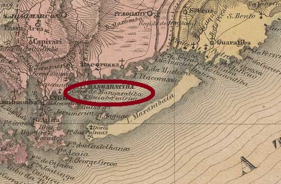
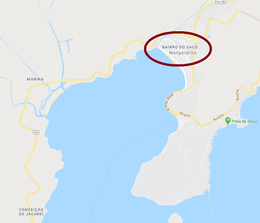
Saco means in Brazil, among others, a small bay. The Saco River flows into the Mangaratiba Bay, located over 100 km west of Rio de Janeiro. Around the river mouth is nowadays the Saco Beach, a tourist quarter of the town Mangaratiba, which has a post office since 1823. According to R. Koester (Carimbologia XXVII), the existence of two post agencies in the Empire so close to each other can be explained through the better access facilities of Saco de Mangaratiba.
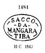
The Sacco da Mangaratiba post office was created in September 1840 (NOVA MONTEIRO: Administrações e Agencias Postaes do Brasil Imperio, in Brasil Filatelico/RJ, 1934-5; Reprint SPP 1994-1999) and operated until June 1902 (NOVAES, Paulo: agenciaspostais.com.br). Three imperial cancels are known, of which SRJ-2345a is the oldest one. It occurs in black and brown from the beginning until at least 1856, as presented by Paulo Ayres (Catálogo de Carimbos Brasil-Império, S. Paulo, 1937, 1942) under #1484:
SRJ-2345a, Paulo Ayres #1484
The lines between words are faded out in later copies of this cancel. It is followed by SRJ-2345b, which can be found in objects between 1878 and 1881 and was also depicted by P. Ayres (op. cit. p. 125):
SRJ-2345b, P. Ayres p.125
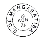
The last imperial cancel SRJ-2345c (Coll. Karlheinz Wittig) has a double circle with the inscription SACCO DE MANGARATIBA above and a diamond ornament below, containing a black dot. Found on stamps used in 1883 and 1884.
GoogleMaps
Siehe auch Mangaratiba (R. Koester: Carimbologia XXVII)
Saco heißt in Brasilien u.a. eine kleine Bucht. Der Fluss Saco mündet in die Bucht von Mangaratiba, über 100 km westlich von Rio de Janeiro gelegen. An dieser Mündung befindet sich heute der Saco Strand (Praia do Saco), ein touristischer Vorort von Mangaratiba. Dieses Städtchen hat ein Postamt seit 1823, so wundert man sich, dass im nahen Saco eine weitere Postagentur kurze Zeit später eröffnet wurde. Laut R. Koester (Carimbologia XXVII) soll Saco da Mangaratiba damals wesentlich leichter zugänglich gewesen sein, als die Stadt Mangaratiba.
Das Postamt von Sacco da Mangaratiba wurde im September 1840 errichtet (NOVA MONTEIRO: Administrações e Agencias Postaes do Brasil Imperio, in Brasil Filatelico/RJ, 1934-5; Reprint SPP 1994-1999) und blieb in Betrieb bis Juni 1902 (NOVAES, Paulo: agenciaspostais.com.br). Drei Stempel aus der Kaiserzeit sind bekannt, davon SRJ-2345a der älteste ist. Er kommt von Beginn an in schwarz und braun vor, bis frühestens 1856, und wurde bereits durch Paulo Ayres (Catálogo de Carimbos Brasil-Império, S. Paulo, 1937, 1942) unter #1484 vorgestellt:
SRJ-2345a, Paulo Ayres Nr. 1484
Bei späteren Exemplaren sind die Linien zwischen den Worten nicht mehr sichtbar. Der nächste Stempel ist SRJ-2345b, anzutreffen auf Objekten datiert zwischen 1878 und 1881, der auch durch P. Ayres (op. cit. S. 125) bekannt gemacht wurde:
SRJ-2345b, P.Ayres S. 125
Der dritte Stempel der Kaiserzeit, SRJ-2345c (Samml. Karlheinz Wittig), hat einen Doppelkreis mit der Inschrift SACCO DE MANGARATIBA oben und einem rautenförmigen Ornament unten, das einen schwarzen Punkt beinhaltet. Gefunden auf Objekten mit Datum 1883-1884.
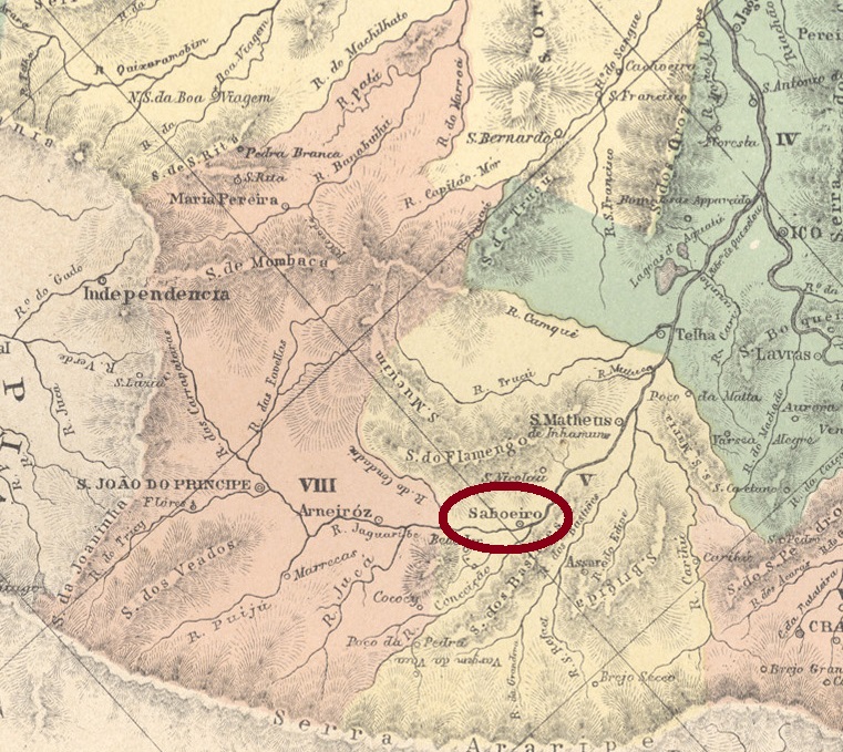
Villiers de l’Ile Adam: Carta (…) da Provincia do Ceará, 1849
See also São Matheus (SCE-0295)
Since the word Saboeiro derivates from sabão (= soap), presumably among the first settlers there were important soap merchants. Anyway, the history of this locality is close related to the neighbour São Matheus, of which it was a dependency in February 1823, having been separated from and annexed to for many times during more than a century. Saboeiro became a Villa for the first time in November 1851, and has an own municipality since May 1935.
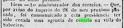
Nova Monteiro (Administrações e Agencias Postaes do Brasil Imperio, in Brasil Filatelico/RJ, 1934-5; Reprint SPP 1994-1999) lists the post office with creation date in October 1852, but this possibly took place one month later, as the local press reports:
O Cearense, December 13, 1852
Only one early cancel is known, and certainly it is not the earliest, for the sole copy is dated 1896. SCE-0305b (Coll. José A. Junges) has a double circle with the inscription SABOEIRO above, and the date in the centre.
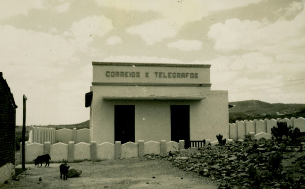
Saboeiro Post Office/Postamt (ca. 1950, IBGE)Atlas do Imperio do Brasil, 1868
Siehe auch São Matheus (SCE-0295)
Da das Wort Saboeiro aus sabão (= Seife) stammt, ist es anzunehmen, dass unter den ersten Siedlern wichtige Seifenhändler dabei waren. Wie es dem auch sei, die Geschichte dieser Ortschaft ist eng mit dem Nachbarort São Matheus verbunden. Saboeiro war in Februar 1823 São Matheus unterstellt, als dieser erstmals zur Villa aufstieg, und im Lauf der kommenden 110 Jahren würden sich beide Orte mehrmals voneinander trennen und wieder zusammen tun. Im November 1851 wurde Saboeiro erstmals eine Villa, und seit Mai 1935 ist es ein eigener Município.
Nova Monteiro (Administrações e Agencias Postaes do Brasil Imperio, in Brasil Filatelico/RJ, 1934-5; Reprint SPP 1994-1999) listet diese Postagentur mit Entstehungsdatum im Oktober 1852, aber möglicherweise fand dies genau ein Monat später statt, wie aus der Lokalpresse hervorgeht:
O Cearense, 13. Dezember 1852
Nur ein früher Stempel ist überliefert, und dieser ist sicherlich nicht der älteste, da das einzig vorhandene Exemplar dar Jahr 1896 trägt. SCE-0305b (Samml. José A. Junges) hat einen Doppelkreis mit der Inschrift SABOEIRO oben, dazu das Datum in der Mitte.
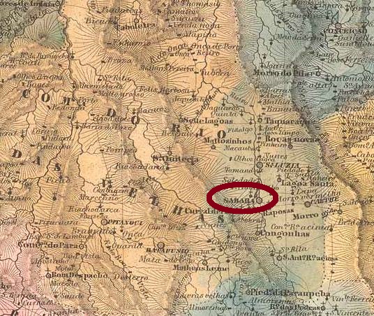
Villiers de l’Ile Adam, Carta (…) da Provincia de Minas Geraes, 1849
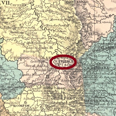
The Villa Real de Nossa Senhora da Conceição de Sabará was founded through a king’s decree (Provisão Real) in July 1711, before the creation of the Minas Gerais captain possession in 1720. The name Sabará derives from the tupi-guarani itá’berab’ (= brilliant stone), a direct reference to the abundant precious stones which determined the further wealth and history of the region. Sabará was soon made the capital of the Rio das Velhas county and ascended to a town in 1838.
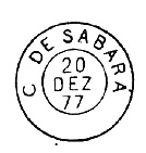
Nova Monteiro (Administrações e Agencias Postaes do Brasil Imperio, in Brasil Filatelico/RJ, 1934-5; Reprint SPP 1994-1999) states the post office creation date already in March 1798, whereas the Imperial Mail Register (Tabella das Agencias do Correio do Imperio) of 1885 writes the year 1829. The first known cancel is pre-philatelic: SMG-2675a (RHM P-MG-57) occurs in sepia:
SMG-2675a, RHM P-MG-57
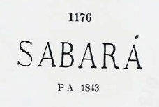
It is followed by SMG-2675b, which occurs in black, red and sepia on stamps between 1843 and 1850ff and was already presented by Paulo Ayres (Catálogo de Carimbos Brasil-Império, S. Paulo, 1937, 1942) under # 1176, although the accent over the last letter A apparently does not exist:
SMG-2675b, Paulo Ayres # 1176
The two next cancels were also published by P. Ayres. SMG-2675c (on page 126) is found in black and red between 1877 and 1892, but in the supplied image there is a missing dot after letter C:
SMG-2675c, (P. Ayres op.cit.)
The French-type SMG-2675d (Ayres op. cit. p. 118) shows dates between 1885 and 1889:
SMG-2675d,(P. Ayresop.cit.)
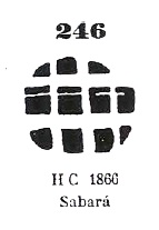
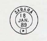
The last early Sabará cancel might be already republican, for the found copies have dates between 1890 and 1896. SMG-2675e (image from the internet) has a double circle with the inscriptions SABARÁ above and (MINAS) below, with the date in the centre. Finally, Paulo Ayres has also shown a mute cancel under # 246:
Paulo Ayres #246Atlas do Imperio do Brasil, 1868
Die Villa Real de Nossa Senhora da Conceição de Sabará wurde im Juli 1711 durch ein königliches Dekret (Provisão Real) gegründet, also noch vor der Entstehung von Minas Gerais in 1720. Der Name Sabará hat einen tupi-guarani-Ursprung, itá’berab’ (= glänzender Stein): ein direkter Hinweis auf die reichlich vorkommenden Edelsteine, die das Reichtum und die Geschichte der ganzen Region bestimmen würden. Sabará wurde bald die Hauptstadt des Verwaltungsbezirks Rio das Velhas und stieg 1838 zur Stadt auf.
Nova Monteiro (Administrações e Agencias Postaes do Brasil Imperio, in Brasil Filatelico/RJ, 1934-5; Reprint SPP 1994-1999) datiert die Entstehung des Postamtes im März 1798, während das Verzeichnis der kaiserlichen Postämter (Tabella das Agencias do Correio do Imperio) von 1885 dafür das Jahr 1829 schreibt. Der erste Stempel, SMG-2675a (RHM P-MG-57) stammt bereits aus der Vorphila-Zeit und kommt in der Farbe sepia vor:
SMG-2675a, RHM P-MG-57
Ihm folgt SMG-2675b, der in Schwarz, rot und sepia auf Marken zu sehen ist, die zwischen 1843 und 1850ff gebraucht wurden. Dieser Stempel wurde bereits durch Paulo Ayres (Catálogo de Carimbos Brasil-Império, S. Paulo, 1937, 1942) unter Nr. 1176 vorgestellt, wobei es den Akzent über dem letzten A offenbar nicht gibt:
SMG-2675b, Paulo Ayres Nr. 1176
Die beiden nächsten Abstempelungen wurden auch von P. Ayres publik gemacht. SMG-2675c (auf S. 126) kommt in schwarz und rot zwischen 1877 und 1892 vor, aber in seiner Abbildung fehlt ein Punkt nach Buchstabe C:
SMG-2675c, (Paulo Ayres, op. cit.)
SMG-2675d (Ayres op. cit. S. 118) ist ein „französischer-Typus“ und weist Daten zwischen 1885 und 1889 vor:
SMG-2675d, (Paulo Ayres, op. cit)
Der letzte frühe Stempel Sanbarás könnte bereits republikanisch sein, da die bisher gefundene Exemplare Daten zwischen 1890 und 1896 haben. SMG-2675e (Abb. aus dem Internet) hat einen Doppelkreis mit den Inschriften SABARÁ oben und (MINAS) unten, dazu das Datum in der Mitte. Schließlich hat Paulo Ayres (op. cit.) auch einen stummen Stempel aus Sabará unter Nr. 246 aufgelistet:
This post deals among others with all unsolved cases related to post offices beginning with Q-R. One can find here alternative toponyms, unknown localities and eventually also mysterious cancels to be identified, listed alphabetically, whenever possible.
Diese Post soll unter anderem alle unerledigten Fälle bei den Q-R-Postämtern auflisten. Hier werden alternative Ortsnamen, unbekannte Ortschaften und eventuell auch rätselhafte Stempel vorgestellt. Alles in alphabetischer Folge, wenn immer möglich.
Q (MN): to be presented under / wird besprochen unterRio de Janeiro in Provincial Capitals and Administrations / Provinzhauptstädten und –postverwaltungen (2023)
R (MN): to be presented under / wird besprochen unterRio de Janeiro in Provincial Capitals and Administrations / Provinzhauptstädten und –postverwaltungen (2023)
Rancho-Mirim (MG): This freguesia post office in Minas Gerais was listed in the Imperial Mail Register (Tabella das Agencias do Correio do Imperio) of 1885 with creation year 1879. The economic data indicate a rather small agency. It is possibly a misprint, for no further information has been found to date.
Tabella das Agencias do Correio do Imperio, 1885
Diese Freguesia in Minas Gerais hatte laut Verzeichnis der Kaiserlichen Postämter (Tabella das Agencias do Correio do Imperio) von 1885 seit 1879 ein eigenes Postamt. Die aufgelisteten Wirtschaftsdaten weisen auf eine eher kleine Agentur hin. Möglicherweise liegt hier ein Druckfehler vor, da bisher keine weitere Information auffindbar ist.
Recife (PE): to be presented under / wird besprochen unterPernambuco in Provincial Capitals and Administrations / Provinzhauptstädten und –postverwaltungen (2023)
Retiro da Lagoa (MG): see/sieheSanto Antonio da Lagoa (SMG-2965)
Ribeirão de Sant’Anna (RJ): see/sieheSant’Anna dos Tocos (SRJ-2170)
Rio Bonito de Valença (RJ): see/sieheSanto Antonio do Rio Bonito (SRJ- 0910)
Rio Grande do Norte (RN): to be presented under / wird besprochen unterRio Grande do Norte in Provincial Capitals and Administrations / Provinzhauptstädten und –postverwaltungen (2023)
Rio Grande do Sul (RS): to be presented under / wird besprochen unterRio Grande do Sul in Provincial Capitals and Administrations / Provinzhauptstädten und –postverwaltungen (2023)
Rio de Janeiro (MN): to be presented under / wird besprochen unterRio de Janeiro in Provincial Capitals and Administrations / Provinzhauptstädten und –postverwaltungen (2023)
Rio Preto do Serro (MG): see/sieheSão Gonçalo do Rio Preto (SMG-2325)
Rizonha (MG): see/sieheSão Romão (SMG-2565), Villa Risonha (VMG-3825) and/und Villa da Manga (VMG-3660)
Rua … (MN): to be presented under / wird besprochen unterRio de Janeiro in Provincial Capitals and Administrations / Provinzhauptstädten und –postverwaltungen (2023)
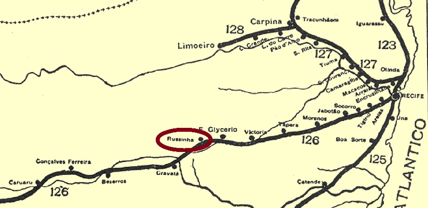
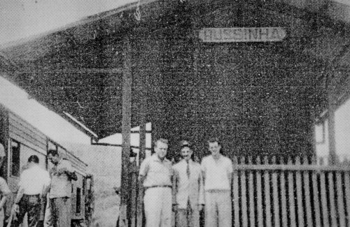
Russinha was a small village in the Serra das Russas situated in the municipality of Gravatá, over 70 km west of the province capital Recife, which hosted a train station of the Estrada de Ferro de Recife a Caruaru railway from 1887 on. Originally, the station should be called Serra, but the name Russinha has appeared in the regional press from the beginning.
From 1904 until 1950 the railway was run by the Great Western Co., between 1950 and 1975 it belonged to the Rede Ferroviária do Nordeste, and from then on until operation end in 1996, to the Rede Ferroviária Federal S.A. Now the station house is demolished, but the tracks are still there (estacoesferroviarias.com.br).
We assume that the station post office was created between 1887 and 1889, but the search for an exact date remains unsuccessful. No imperial cancel has been found either.
ca. 1960 (Photo: L.R.F. de A. Bonfim, apud estacoesferroviarias.com.br)
Russinha war ein Dörfchen im Município von Gravatá in der Serra das Russas, etwas über 70 km westlich von der Provinzhauptstadt Recife gelegen, das in 1887 ein Bahnhof der Estrada de Ferro de Recife a Caruaru erhielt. Ursprünglich sollte der Bahnhof Serra heißen, aber vom Anfang an taucht der Name Russinha in der Regionalpresse auf.
Zwischen 1904 bis 1950 war die Bahnstrecke Eigentum der Great Western Co., danach bis 1975 gehörte sie der Rede Ferroviária do Nordeste, und von 1975 bis Betriebsende in 1996 fuhren die Züge der Rede Ferroviária Federal S. A. Heute ist das Bahnhaus abgerissen, die Schienen sind aber noch da (estacoesferroviarias.com.br).
Wir nehmen an, dass das Bahnhofspostamt irgendwann zwischen 1887 und 1889 entstanden ist, konnten aber bisher leider kein Datum davon ermitteln. Ein Poststempel der Kaiserzeit wurde ebenso wenig gefunden.
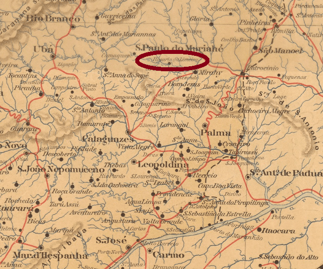
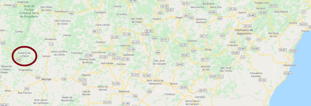
The freguesia of Nossa Senhora do Rozario (or Rosário) da Limeira was founded in June 1876 in the municipality of São Paulo de Muriahé, round 200 km southeast of the former province capital Ouro Preto. With an economy based in coffee production, Rosário da Limeira emancipated as a municipality in December 1995.
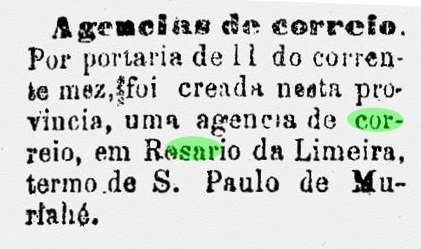
According to Paula Sobrinho (História Postal de Minas Gerais, Belo Horizonte, 1997), the post office was created in June 1887. This can be ratified by the regional press:
União Postal, June 19, 1887
One early cancel is known: RMG-2205a (Coll. José A. Junges) has a double circle with the inscriptions ROZARIO DA LIMEIRA above and (MINAS) below, with the date in the centre. Only one copy found, dated 1890.
Google Maps
Die Freguesia von Nossa Senhora do Rozario (oder Rosário) da Limeira wurde im Juni 1876 im Município von São Paulo de Muriahé gegründet und lag ca. 200 km südöstlich der ehemaligen Provinzhauptstadt Ouro Preto entfernt. Große Kaffeeplantagen haben zum Wohlstand der Gemeinde beigetragen, und Rosário da Limeira wurde ein eigenständiger Município im Dezember 1995.
Laut Paula Sobrinho (História Postal de Minas Gerais, Belo Horizonte, 1997) entstand das örtliche Postamt im Juni 1887, was durch die Regionalpresse bestätigt wird:
União Postal, 19. Juni 1887
Nur ein früher Stempel ist bekannt: RMG-2205a (Samml. José A. Junges) hat einen Doppelkreis mit den Inschriften ROZARIO DA LIMEIRA oben und (MINAS ) unten, dazu das Datum in der Mitte. Nur ein Exemplar aus 1890 überliefert.
Bellegard-Niemeyer: Charta Corographica do Rio de Janeiro, 1867
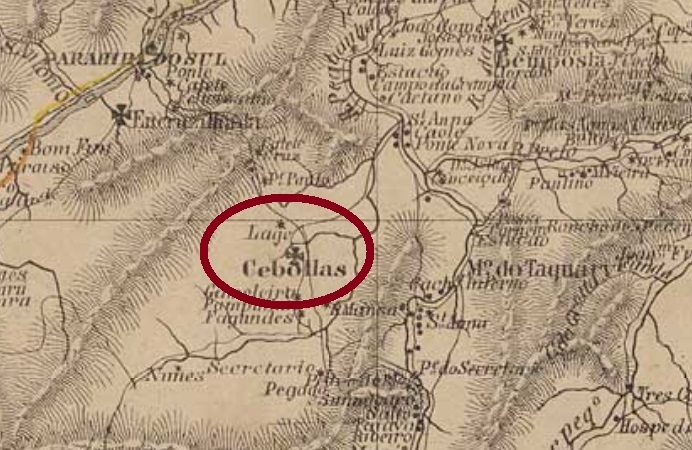
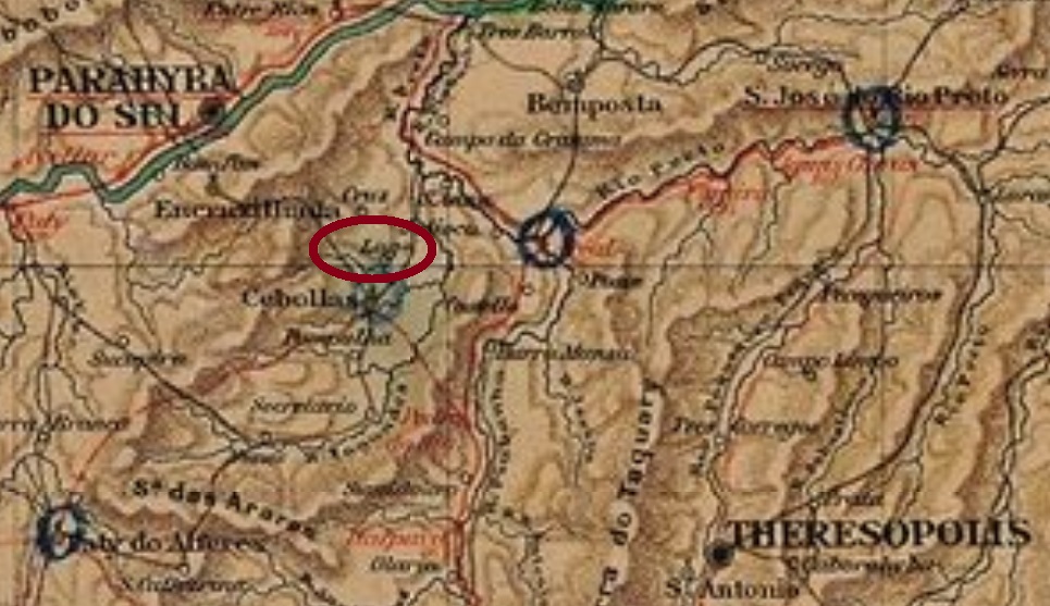
Rumo da Lage (= Ledge Way) was a tiny locality in the environs of the freguesia of Santana de Cebollas (also written Sebollas) in the municipality of Parahyba do Sul, located over 100 km north of Rio de Janeiro. It must remain one of the mysteries of Brazil’s postal history why such a village, which is barely visible on contemporary maps, was given a post office during 14 years. Since no office in the much bigger Santana de Cebollas is known to date, we must assume that the mail to and from it had to pass through Rumo da Lage.
According to Paulo Novaes (agenciaspostais.com.br), the post office was created in November 1882, which is ratified by this press note:
Gazeta da Tarde, November 6, 1882
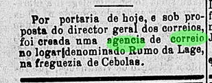
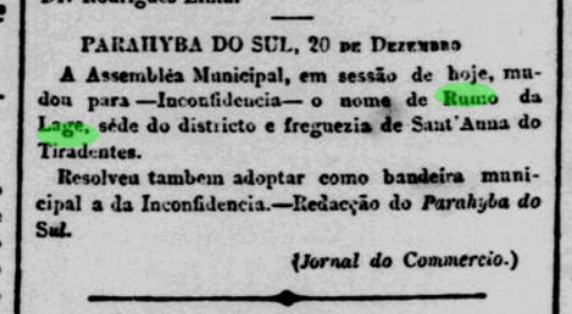
The agency was renamed Inconfidência in February 1896. At that time, Santana de Cebollas had also changed the toponym, to Santana de Tiradentes, a name that soon had to disappear as unnoticed as it had appeared. A press release of December 1895 reveals that Rumo da Lage, which was from then on to be called Inconfidência, had been the principal office of the whole freguesia:
Jornal do Commercio, December 21, 1895
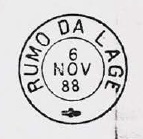
Two imperial cancels of Rumo da Lage are known. RRJ-2165a (Coll. José A. Junges) is found on stamps with dates between 1886 and 1888: a double circle with the inscription RUMO DA LAGE above an a diamond ornament below, which consists of four small diamonds. RRJ-2165b is found on pieces between 1888 and 1893, and was already presented by Paulo Ayres (Catálogo de Carimbos Brasil-Império, S. Paulo, 1937, 1942), on page 123:
Rumo da Lage (= Felsplattenweg) war eine winzige Ortschaft der Freguesia von Santana de Cebollas (ou Sebollas) im Município von Parahyba do Sul, die über 100 km nördlich von Rio de Janeiro lag. Es bleibt ein Geheimnis der brasilianischen Postgeschichte, warum solcher Ort, kaum auf damaligen Landkarten sichtbar, ein eigenes Postamt 14 Jahre lang haben durfte. Da kein Agentur in Santana de Cebollas bisher bekannt ist, nehmen wir an, dass der ganze Postverkehr von und nach dieser Freguesia durch Rumo da Lage gehen musste.
Laut Paulo Novaes (agenciaspostais.com.br) entstand das Postamt im November 1882, was durch die Presse bestätigt wird:
Gazeta da Tarde, 6. November 1882
Die Agentur wurde im Februar 1896 in Inconfidência umbenannt. Damals hieß Santana de Cebollas bereits Santana de Tiradentes, ein Ortsname, der bald so geräuschlos verschwinden würde, wie er aufgetaucht war. Eine Pressemittelung vom Dezember 1895 erklärt außerdem, dass Rumo da Lage der Hauptsitz der Freguesia war, und den neuen Namen zu diesem Zeitpunkt bekam:
Jornal do Commercio, 21. Dezember 1895
Zwei Abstempelungen der Kaiserzeit sind überliefert. RRJ-2165a (Samml. José A. Junges) ist auf Stempeln zu finden, die Daten zwischen 1886 und 1888 aufweisen: ein Doppelkreis mit der Inschrift RUMO DA LAGE oben und einem Ornament in Rautenform unten, das aus vier kleinen Rauten besteht. RRJ-2165b, bereits durch Paulo Ayres (Catálogo de Carimbos Brasil-Império, S. Paulo, 1937, 1942) auf S. 123 vorgestellt, wurde auf Marken und Belegen von 1888-1893 gefunden: