Print edition update of May 17, 2020
Other names: Barra do Rio das Velhas, Guacuhy
See also Guaicuhy (R. Koester: Carimbologia XXI)
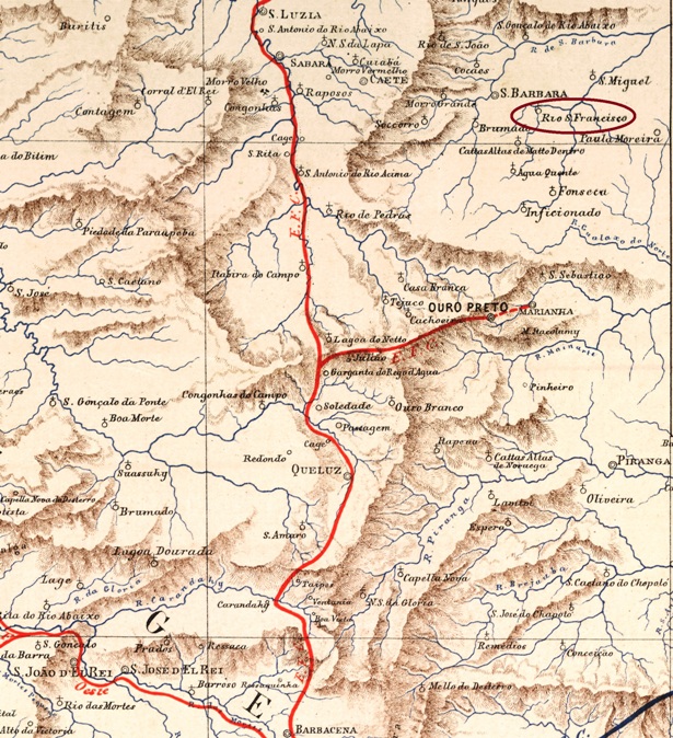
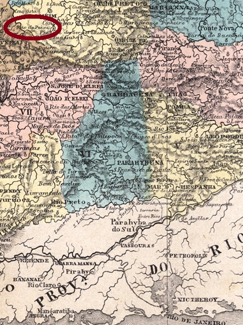
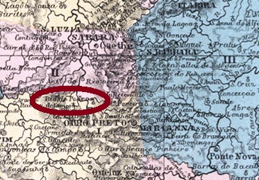
There were two Rio das Velhas (= Old Ladies’ River) in the imperial province of Minas Gerais. The first one, now called Araguari, has its source in the south-western Serra da Canastra and flows westwards until it reaches the Paranaiba. The second Rio das Velhas is historically by far more important, for it flows through regions that formed politics and wealth of the whole region. It springs up from the hills near the former capital Ouro Preto and runs 800 km towards northwest into the São Francisco River.
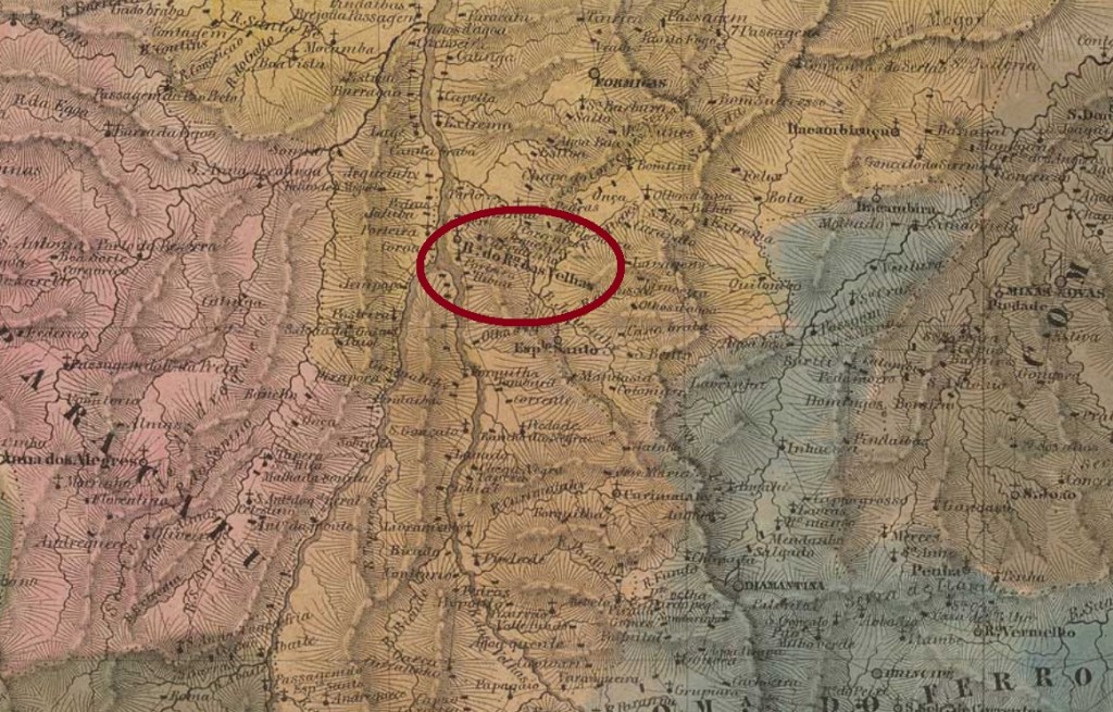
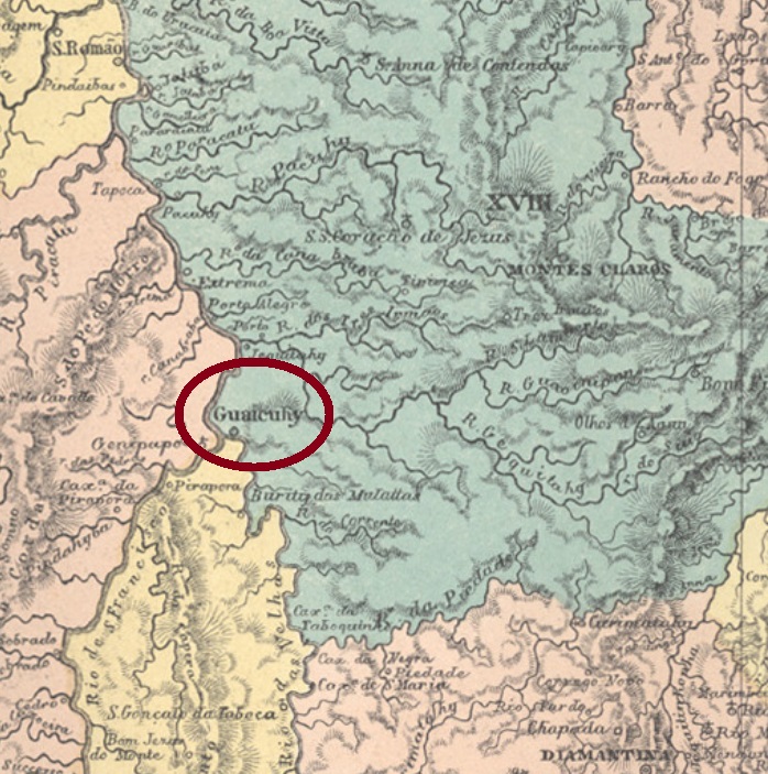
Around the river mouth there was the former freguesia of Nossa Senhora do Bom Sucesso e Almas da Barra do Rio das Velhas, founded in 1839 in the municipality of Curvello. The freguesia, which ascended to a Villa in November 1861 changing the toponym to Guaicuhy, is nowadays a district of the municipality of Várzea da Palma.
There are three dates for the creation of the post office. Nova Monteiro (Administrações e Agencias Postaes do Brasil Imperio, in Brasil Filatelico/RJ, 1934-5; Reprint SPP 1994-1999) writes October 28, 1833 for Rio das Velhas (without Barra), whereas Paula Sobrinho (História Postal de Minas Gerais, Belo Horizonte, 1997) reports the October 20, 1858 for Guaicuhy, and the Imperial Mail Register (Tabella das Agencias do Correio do Império) of 1885 lists 1879 for Guacuhy. Apparently this agency has been twice closed.
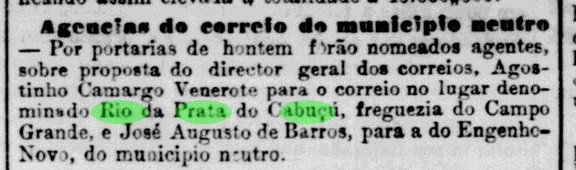
Nova Monteiro’s reference is surely related to the list of all post offices in Minas Gerais of that date, which was published one month later:

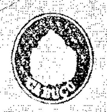
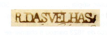
Here it is quite clear that there was an agency in Barra do Rio das Velhas, whereas the Rio das Velhas in the left column refers to a comarca, e.g. an administrative district with four post offices (Sabará, Caethé, Itabira and Pitangui). And it is also very clear that the Barra office undoubtedly must refer to the pre-philatelic cancel RMG-2123a, as presented by the RHM catalogue:

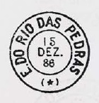
Later cancels from Guaicuhy were already presented by R. Koester (Carimbologia XXI).
Buchtext-Aktualisierung vom 17. Mai 2020
Andere Namen: Barra do Rio das Velhas, Guacuhy
Siehe auch Guaicuhy (R. Koester: Carimbologia XXI)
Im kaiserlichen Minas Gerais gab es zwei Flüsse, die Rio das Velhas (= Fluss der Alten Frauen) hießen. Der erste ist der heutige Rio Araguari, der seine Quelle in der Serra da Canastra im Südwesten der Provinz hat, und von dort in Richtung Westen bis zur Mündung in den Paranaíba fließt. Der zweite Rio das Velhas ist historisch viel wichtiger, denn er durchquert die Gebiete, die Politik und Wirtschaft der Region bestimmt haben. Dieser Fluss entspringt den Bergen um der Hauptstadt Ouro Preto und machr seinen 800 km langen Weg nach Nordwesten, bis er den Rio São Francisco erreicht.
An dieser Flussmündung gab es die in 1839 gegründete Freguesia von Nossa Senhora do Bom Sucesso e Almas da Barra do Rio das Velhas. Diese wurde im November 1861 zur Villa de Guaicuhy, und unter diesem Namen ist die Ortschaft heute ein Distrikt des Município von Várzea da Palma.
Drei Daten für die Gründung des Postamtes sind überliefert. Nova Monteiro (Administrações e Agencias Postaes do Brasil Imperio, in Brasil Filatelico/RJ, 1934-5; Reprint SPP 1994-1999) schreibt den 28. Oktober 1833 für Rio das Velhas (ohne Barra), während Paula Sobrinho (História Postal de Minas Gerais, Belo Horizonte, 1997) gibt den 20. Oktober 1858 für Guaicuhy, und das Verzeichnis der kaiserlichen Postämter (Tabella das Agencias do Correio do Império) von 1885 listet das Jahr 1879 für Guacuhy. Scheinbar wurde das Postamt also zweimal geschlossen.
Nova Monteiros Angabe basiert sicherlich auf eine damalige Liste aller Postämter in Minas Gerais, die im November 1833 veröffentlicht wurde:
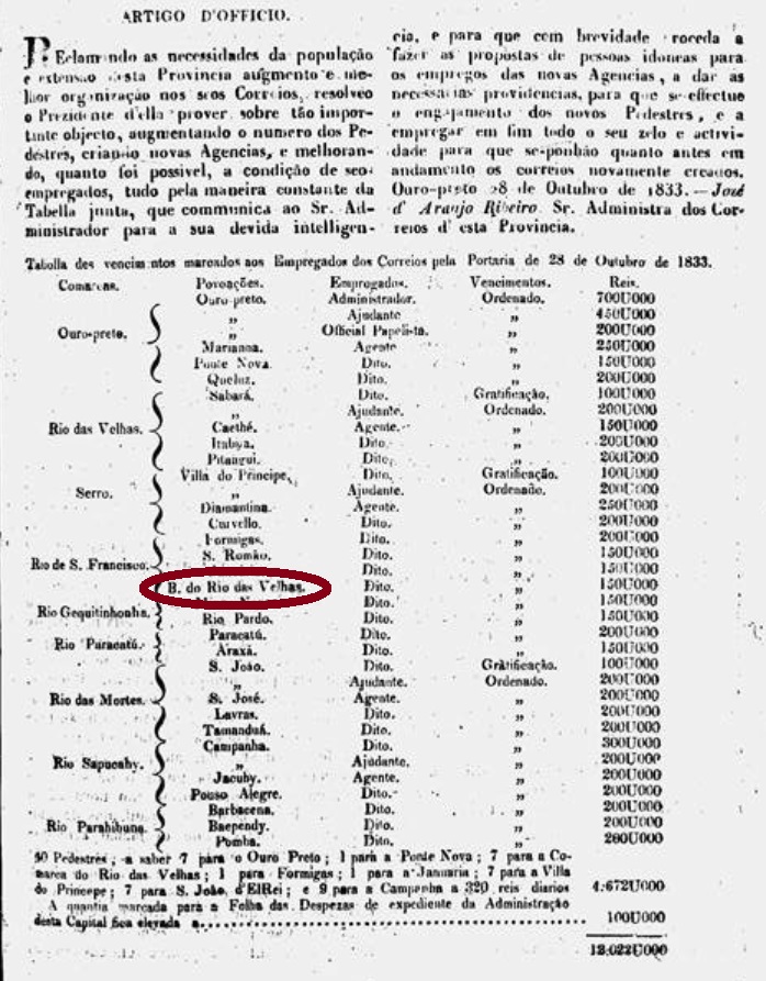
Hier geht klar hervor, dass ein Postamt in Barra do Rio das Velhas aktiv war, während der Rio das Velhas in der linken Spalte eine comarca ist, also ein Verwaltungsbezirk, wo man vier Postämter (Sabará, Caethé, Itabira and Pitangui) aufgelistet hat. Es ist auch ziemlich klar, dass das Barra-Postamt fast zwangsläufig mit dem Vorphila-Stempel RMG-2123a zu tun hat, wie im RHM-Katalog abgebildet:
Spätere Abstempelungen unter Guaicuhy wurden bereits durch R. Koester (Carimbologia XXI) vorgestellt.