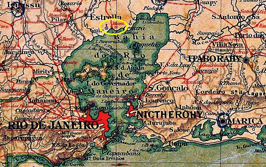
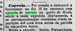
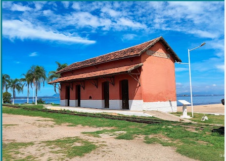
Mauá was a port on Guanabara Bay in the Vila de Magé area, 60 kilometres north of the capital Rio de Janeiro. In April 1854, Brazil’s first railway station was inaugurated there by the E.F. de Mauá railway company (Guia-de-Pacobaíba Line). In 1888, the line was transferred to E. F. Príncipe do Grão-Pará, and from 1890 until the line was closed in 1962, it belonged to E. F. Leopoldina. In March 1946, the port and railway station were renamed Guia de Pacobaíba. The tracks are still there, and the station building has been restored several times and destroyed again by vandalism. Today it serves as a museum.
1885 (Photo: Marc Ferrez on estacoesferroviarias.com.br)In April 2025 (photo: Antonio C. de Sá, on Google Maps)
According to regional press reports, there has been a post office there since May 1880.
Gazeta de Noticias, 09.05.1880
No imperial postmark from this station/port has been found to date.
Atlas do Imperio do Brasil, 1868
Andere Namen: Guia de Pacobaíba (1946)
Mauá war ein Hafen an der Guanabara-Bucht im Gebiet der Vila de Magé, 60 Kilometer nördlich der Hauptstadt Rio de Janeiro. Im April 1854 wurde dort Brasiliens erster Bahnhof durch die Eisenbahngesellschaft E.F. de Mauá (Guia-de-Pacobaíba-Linie) eingeweiht. 1888 wechselte die Linie zur E. F. Príncipe do Grão-Pará und von 1890 bis zur Streckenstilllegung im Jahr 1962 gehörte sie zur E. F. Leopoldina. Im März 1946 wurden Hafen und Bahnhof in Guia de Pacobaíba umbenannt. Die Gleise sind noch vorhanden, das Bahnhofsgebäude wurde mehrfach restauriert und wieder durch Vandalismus zerstört. Heute dient es als Museum.
1885 (Foto: Marc Ferrez auf estacoesferroviarias.com.br)Im April 2025 (Foto: Antonio C. de Sá, auf Google Maps)
Wie die regionale Presse meldete, gab es dort ein Postamt seit Mai 1880.
Gazeta de Noticias, 09.05.1880
Bisher wurde kein kaiserliche Poststempel aus diesem Bahnhof/Hafen gefunden.
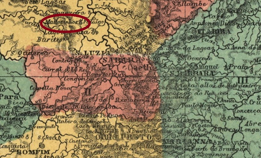
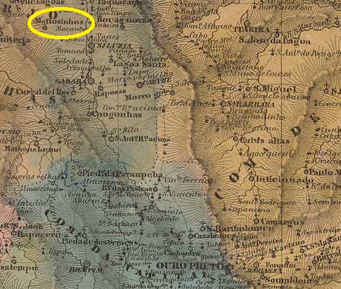
The Freguesia de Bom Jesus de Mattosinhos existed since August 1823, belonged to the Vila de Sabará and was located on the east bank of the Ribeirão da Mata, 150 kilometres northwest of the provincial capital Ouro Preto. In March 1847, the parish was subordinated to the Vila de Santa Luzia and in September 1923 it became a district of the Município de Pedro Leopoldo. Since December 1943, Matozinhos (as it is spelled today) has been an independent município.
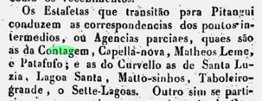
Nova Monteiro writes in ‘Administrações e Agencias Postaes do Brasil Imperio’ (Brasil Filatelico/RJ, 1934–1935; reprinted by SPP 1994–1999) that there has been a post office there since June 1868. R. Koester gives a date in July of the same year in Carimbologia XXVI, which could correspond to the agency’s opening. However, Mattosinhos was already operating as a so-called partial post office in October 1839, as reported by the regional press:
O Universal, 21 October 1839
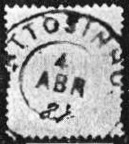
The only imperial postmark to date is MMG-1585b (fig. Koester, op. cit.):
MMG-1585b (RK) 1887-1901Villiers de l’Ile Adam: Carta (…) da Provincia de Minas Geraes, 1849
Andere Schreibweise: Matozinhos
Die Freguesia de Bom Jesus de Mattosinhos bestand seit August 1823, gehörte zur Vila de Sabará und lag am Ostufer des Ribeirão da Mata, 150 Kilometer nordwestlich der Provinzhauptstadt Ouro Preto. Im März 1847 wurde die Freguesia der Vila de Santa Luzia untergeordnet und im September 1923 als Distrikt zum Município de Pedro Leopoldo. Seit Dezember 1943 ist Matozinhos (wie es heute geschrieben wird) ein eigenständiger Município.
Nova Monteiro schreibt in „Administrações e Agencias Postaes do Brasil Imperio” (Brasil Filatelico/RJ, 1934–1935; Nachdruck SPP 1994–1999), dass es dort seit Juni 1868 ein Postamt gab. R. Koester gibt in Carimbologia XXVI ein Datum vom Juli desselben Jahres an, welches der Inbetriebnahme der Agentur entsprechen könnte. Allerdings war Mattosinhos bereits im Oktober 1839 als eine sogenannte partielle Postagentur, wie die regionale Presse berichtet:
O Universal, 21.10.1839
Der bisher einzige kaiserliche Poststempel ist MMG-1585b (Abb. Koester, op. cit.):
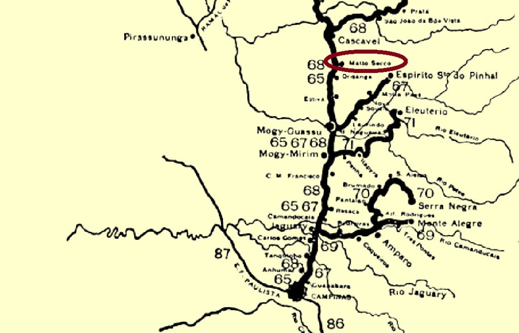
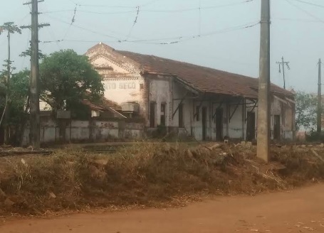
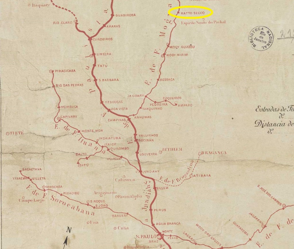
The Matto Secco (Dry Woods) railway station was opened in January 1878 by the E.F. Mogyana railway company (main line). It was in Vila de Mogy-Guassú, 190 kilometres northwest of the provincial capital São Paulo. From 1971 until the line was closed in 1998, it belonged to the FEPASA consortium. Today, the tracks are still there, but the station building looks abandoned.
In August 2021 (photo: Valmir Lima, on Google Maps)
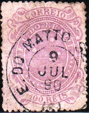
As can be seen from the directory of imperial post offices (Tabella das Agencias do Correio do Imperio, Rio de Janeiro, 1885), there has been a post office at the station since 1881.
The only imperial postmark to date is MSP-0800a (illustration: Felipe Piccinini), which is also available in blue.
MSP-0800a (FP) 1887-1890Estações (…) de São Paulo, Rio de Janeiro e Minas Geraes, 1880
Der Bahnhof Matto Secco (Trockener Wald) wurde im Januar 1878 von der Eisenbahngesellschaft E.F. Mogyana (Hauptlinie) eröffnet. Er lag in der Vila de Mogy-Guassú, 190 Kilometer nordwestlich der Provinzhauptstadt São Paulo. Von 1971 bis zur Streckenstilllegung im Jahr 1998 gehörte die Linie dem FEPASA-Konsortium. Heute sind die Gleise noch vorhanden, doch das Bahnhofsgebäude macht einen verlassenen Eindruck.
Im August 2021 (Foto: Valmir Lima, auf Google Maps)
Wie aus dem Verzeichnis der kaiserlichen Postämter (Tabella das Agencias do Correio do Imperio, Rio de Janeiro, 1885) hervorgeht, gab es seit 1881 ein Postamt am Bahnhof.
Der bisher einzige kaiserliche Poststempel ist MSP-0800a (Abbildung: Felipe Piccinini), den es auch in Blau gibt.
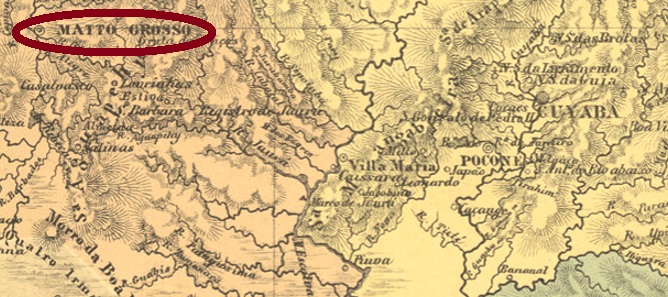
Other names: Villa Bella da Santissima Trindade do Matto Grosso
See also Matto Grosso (Carimbologia 2023), Villa Bella (VMT-0035)
The rather modest settlement of Villa Bella da Santissima Trindade do Matto Grosso (Beautiful Villa of the Holy Trinity in the Dense Jungle) was founded in March 1752 on the eastern bank of the Guaporé River between the Amazon rainforest and the Pantanal. The settlement in this inhospitable and barely accessible area was necessary to secure the newly discovered gold deposits for the Portuguese crown, even though the area was indeed Spanish territory. Villa Bella thus became the first capital of the Capitania of Mato Grosso. In September 1818, it was designated a city and remained the capital of the imperial province of Matto Grosso until August 1835. With the capital moving to Cuiabá, another 520 kilometres to the east, a long period of decline followed. Since November 1978, the municipality has once again been called Vila Bela da Santíssima Trindade.
Three dates of origin have been found for the local post office. The oldest date is likely to be 1799, when the governor of the province opened the postal service. Another date is 1829, as can be seen from the directory of imperial post offices (Tabella das Agencias do Correio do Imperio, Rio de Janeiro, 1885). A further date is March 1847, as Nova Monteiro wrote in Administrações e Agencias Postaes do Brasil Imperio (Brasil Filatelico/RJ, 1934–1935; reprinted by SPP 1994–1999).
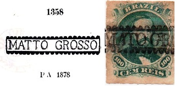
The only imperial postmark with Mato Grosso to date is MMT-0035a, which was given the number 1358 by P. Ayres in the ‘Catálogo de Carimbos Brasil-Império’ (São Paulo, 1937, 1942). Its illustration was corrected by a specimen from the Junges collection.
MMT-0035a (P. A. 1358 – recte JJ), ca. 1840–1882 ff
For stamps with Villa Bella, see VMT-0035; for Cuiabá as the capital of the province of Mato Grosso, see Carimbologia 2023.
Villiers de l’Ile Adam: Carta (…) da Provncia do Matto Grosso, 1850
Andere Namen: Villa Bella da Santissima Trindade do Matto Grosso
Siehe auch Matto Grosso (Carimbologia 2023), Villa Bella (VMT-0035)
Die eher bescheidene Siedlung Villa Bella da Santissima Trindade do Matto Grosso (Schöne Villa der Heiligsten Dreifaltigkeit im Dichten Urwald) wurde im März 1752 am Ostufer des Flusses Guaporé zwischen Amazonas-Urwald und dem Pantanal gegründet. Die Gründung in dieser unwirtlichen und kaum erreichbaren Gegend war notwendig, um die neu entdeckten Goldvorkommen für die portugiesische Krone zu sichern, obwohl sich das Gebiet eigentlich auf spanischem Territorium befand. Villa Bella wurde somit die erste Hauptstadt der Capitania von Mato Grosso. Im September 1818 wurde sie zur Stadt ernannt und war bis August 1835 die Hauptstadt der kaiserlichen Provinz Matto Grosso. Mit dem Wechsel der Hauptstadt nach Cuiabá, das weitere 520 Kilometer östlich liegt, folgte eine lange Periode der Dekadenz. Seit November 1978 heißt der Município wieder Vila Bela da Santíssima Trindade.
Es wurden drei Entstehungsdaten für das örtliche Postamt gefunden. Das älteste Datum dürfte 1799 sein, als der Gouverneur der Provinz den Postdienst eröffnete. Ein weiteres Datum ist 1829, wie aus dem Verzeichnis der kaiserlichen Postämter (Tabella das Agencias do Correio do Imperio, Rio de Janeiro, 1885) hervorgeht. Ein weiteres Datum ist der März 1847, wie Nova Monteiro in Administrações e Agencias Postaes do Brasil Imperio (Brasil Filatelico/RJ, 1934–1935; Nachdruck SPP 1994–1999) schrieb.
Der bisher einzige kaiserliche Poststempel mit Mato Grosso ist MMT-0035a, der von P. Ayres im „Catálogo de Carimbos Brasil-Império” (São Paulo, 1937, 1942) die Nr. 1358 erhielt. Seine Abbildung konnte durch ein Exemplar der Sammlung Junges korrigiert werden.
MMT-0035a (P. A. 1358 – recte JJ), ca. 1840–1882 ff
Für Stempel mit Villa Bella siehe VMT-0035, mit Cuiabá als Hauptstadt der Provinz Mato Grosso siehe Carimbologia 2023.
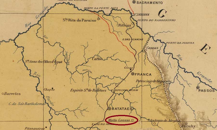
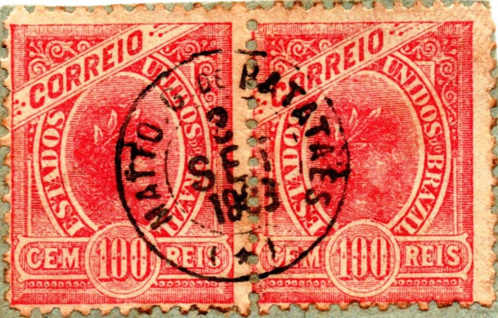
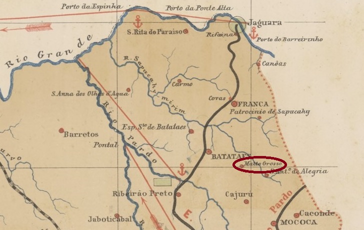
Other names: Arraial de N. Sra. da Piedade, Altinópolis (1918)
The Freguesia de Nossa Senhora da Piedade do Matto Grosso existed since March 1875 and belonged to the Vila de Batataes. It was located 330 km north of the provincial capital São Paulo. In December 1906, it became a vila and twelve years later the city of Altinópolis, in honour of Altino Arantes Marques (1876–1965), the governor of São Paulo (1916–1920) who was born in Batatais.
Altino Arantes (Wikipedia)
As can be seen from the directory of imperial post offices (Tabella das Agencias do Correio do Imperio, Rio de Janeiro, 1885), there had been a post office there since 1879. The only imperial postmark to date is the French type MSP-0795a (Fig. Nikolas Moura):
MSP-0795a (NiM) 1886-1903Provincia de São Paulo, 1886
Andere Namen: Arraial de N. Sra. da Piedade, Altinópolis (1918)
Die Freguesia de Nossa Senhora da Piedade do Matto Grosso bestand seit März 1875 und gehörte zur Vila de Batataes. Sie lag 330 km nördlich der Provinzhauptstadt São Paulo. Im Dezember 1906 wurde sie zur Vila und zwölf Jahre später zur Stadt Altinópolis, zu Ehren von Altino Arantes Marques (1876–1965), dem in Batatais geborenen Gouverneur von São Paulo (1916–1920).
Altino Arantes (Wikipedia)
Wie aus dem Verzeichnis der kaiserlichen Postämter (Tabella das Agencias do Correio do Imperio, Rio de Janeiro, 1885) hervorgeht, gab es dort ein Postamt seit 1879. Der bisher einzige kaiserliche Poststempel ist der französische Typ MSP-0795a (Abb. Nikolas Moura):
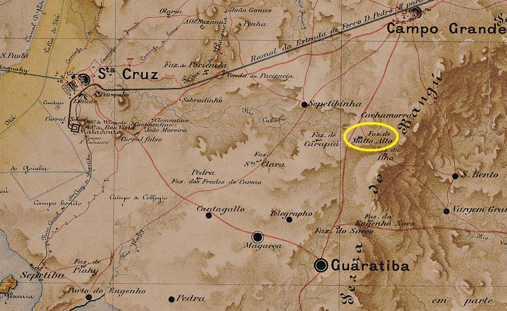
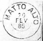
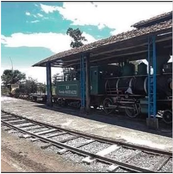
This small settlement was originally a fazenda (farm) established around 1700, which was mainly dedicated to cattle breeding. It was in the Freguesia de Guaratiba in the Município Neutro, 60 km west of the capital Rio de Janeiro. The fazenda still exists today and even has its own 3.8-kilometre-long railway line. It is often used as a location for telenovelas.
Photo: Facebook
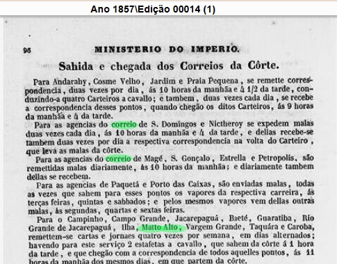
As Nova Monteiro writes in Administrações e Agencias Postaes do Brasil Imperio (Brasil Filatelico/RJ, 1934–1935; reprinted by SPP 1994–1999), there has been a post office there since October 1867. However, postal services had already been available locally for ten years prior to that.
Almanak Laemmert, 1857
The only imperial postmark to date is MMN-1090b (illustration: Koester in Carimbologia XXVII)
MMN-1090b (RK) 1885Distrito Federal, ca. 1920 (agenciaspostais.com.br)
Andere Namen: Fazenda do Matto Alto
Diese kleine Siedlung war ursprünglich eine seit ca. 1700 bestehende Fazenda, die sich vorwiegend der Rinderzucht widmete. Sie lag in der Freguesia de Guaratiba im Município Neutro, 60 km westlich der Hauptstadt Rio de Janeiro. Die Fazenda existiert heute noch und verfügt sogar über eine eigene 3,8 Kilometer lange Bahnlinie. Sie wird gerne als Drehort für Telenovelas genutzt.
Foto: Facebook
Wie Nova Monteiro in Administrações e Agencias Postaes do Brasil Imperio (Brasil Filatelico/RJ, 1934–1935; Nachdruck SPP 1994–1999) schreibt, gab es dort seit Oktober 1867 ein Postamt. Allerdings gab es bereits zehn Jahre zuvor Postdienste vor Ort.
Almanak Laemmert, 1857
Der bisher einzige kaiserliche Poststempel ist MMN-1090b (Abb. Koester in Carimbologia XXVII)
Villiers de l’Ile Adam: Carta (…) das Provincias de Pernambuco, Alagoas e Sergipe, 1848
See also Paulo Affonso (R. Koester: Carimbologia XXX)
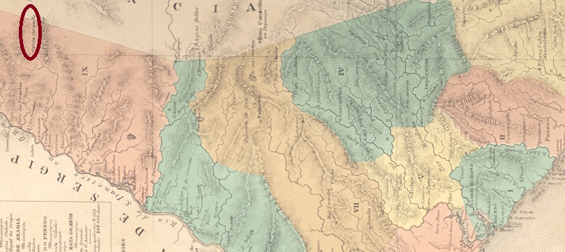
The settlement of Mata do Pau Grande existed since 1808. It belonged to the Freguesia de Tacaratu (today in the state of Pernambuco) and was located near the west bank of the Rio dos Cabaços and the Serra da Mata Grande, 270 kilometres west of the later provincial capital Maceió. In 1835, the chapel of N. Sra. da Conceição da Mata Grande was consecrated. It was subordinate to the Vila de Porto da Folha and was declared both a vila and a freguesia in March 1837. In May 1846, it was downgraded again to the parish of Porto da Folha and in June 1852 it was upgraded again to a village. This was followed by two changes to the place name: in April 1870 it was changed to Paulo Afonso (a town since June 1902) and in May 1929 this municipality was given the name Mata Grande, as it is spelt today.
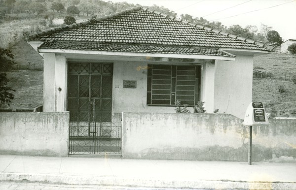
Mata Grande post office, around 1972 (photo: IBGE)
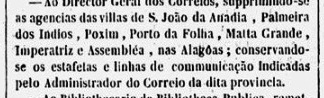
Three dates have been found for the creation of the local post office. The first was in June 1834, as Aldo Cardoso writes in ‘Contribuição para a História dos Correios de Alagoas’ (Maceió, 1969). A second time in 1844, as shown in the directory of imperial post offices (Tabella das Agencias do Correio do Imperio, Rio de Janeiro, 1885). The post office was closed in October 1847, as reported by the official press in Rio de Janeiro.
Gazeta Official/RJ, 13 October 1847, minute from October 7
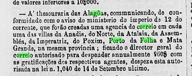
According to the minutes of the Imperial Ministry, the Matta Grande post office was re-established in November 1859.
Expediente do Ministerio do Imperio, 1859
However, no imperial postmark from Matta Grande in the province of Alagoas has been found to date.
Atlas do Imperio do Brasil, 1868
Siehe auch Paulo Affonso (R. Koester: Carimbologia XXX)
Die Siedlung Mata do Pau Grande bestand seit 1808. Sie gehörte zur Freguesia de Tacaratu (heute im Bundesstaat Pernambuco) und lag in der Nähe des Westufers des Rio dos Cabaços sowie der Serra da Mata Grande, 270 Kilometer westlich der späteren Provinzhauptstadt Maceió. Im Jahr 1835 wurde die Kapelle N. Sra. da Conceição da Mata Grande eingeweiht. Sie war der Vila de Porto da Folha untergeordnet und wurde im März 1837 gleichzeitig zur Vila und Freguesia erklärt. Im Mai 1846 erfolgte die erneute Herabstufung zur Freguesia von Porto da Folha und im Juni 1852 der Wiederaufstieg zur Vila. Es folgten zwei Änderungen des Ortsnamens: Im April 1870 wurde er zu Paulo Afonso geändert (Stadt seit Juni 1902) und im Mai 1929 erhielt die Stadt den Namen Mata Grande, wie er heute lautet.
Postamt Mata Grande, um 1972 (Foto: IBGE)
Es wurden drei Entstehungsdaten für das örtliche Postamt gefunden. Erstmals im Juni 1834, wie Aldo Cardoso in „Contribuição para a História dos Correios de Alagoas” (Maceió, 1969) schreibt. Ein weiteres Mal im Jahr 1844, wie aus dem Verzeichnis der kaiserlichen Postämter (Tabella das Agencias do Correio do Imperio, Rio de Janeiro, 1885) hervorgeht. Das Postamt wurde im Oktober 1847 geschlossen, wie die Amtspresse aus Rio de Janeiro meldete.
Gazeta Official/RJ, 13.10.1847, Protokoll des 7.10.
Laut Protokoll des Kaiserlichen Ministeriums wurde das Postamt Matta Grande im November 1859 erneut ins Leben gerufen.
Expediente do Ministerio do Imperio, 1859
Bisher wurde jedoch kein kaiserlicher Poststempel aus Matta Grande in der Provinz Alagoas gefunden.
Villiers de l’Ile Adam: Carta (…) da Provincia da Bahia, 1848
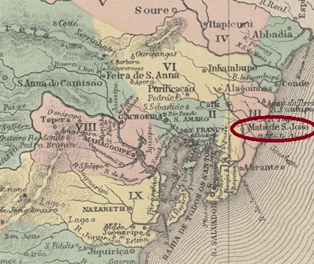
Other names: Mata (1931-1938)
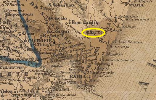
The Freguesia de Senhor do Bonfim da Matta de S. João existed since 1761 on the west bank of the Jacuípe, 60 kilometres north of the colonial capital Salvador da Bahia. In April 1846, it was elevated to the status of a vila and changed its name to Mata in June 1931. In November 1938, it was given back its old name, Mata de São João.
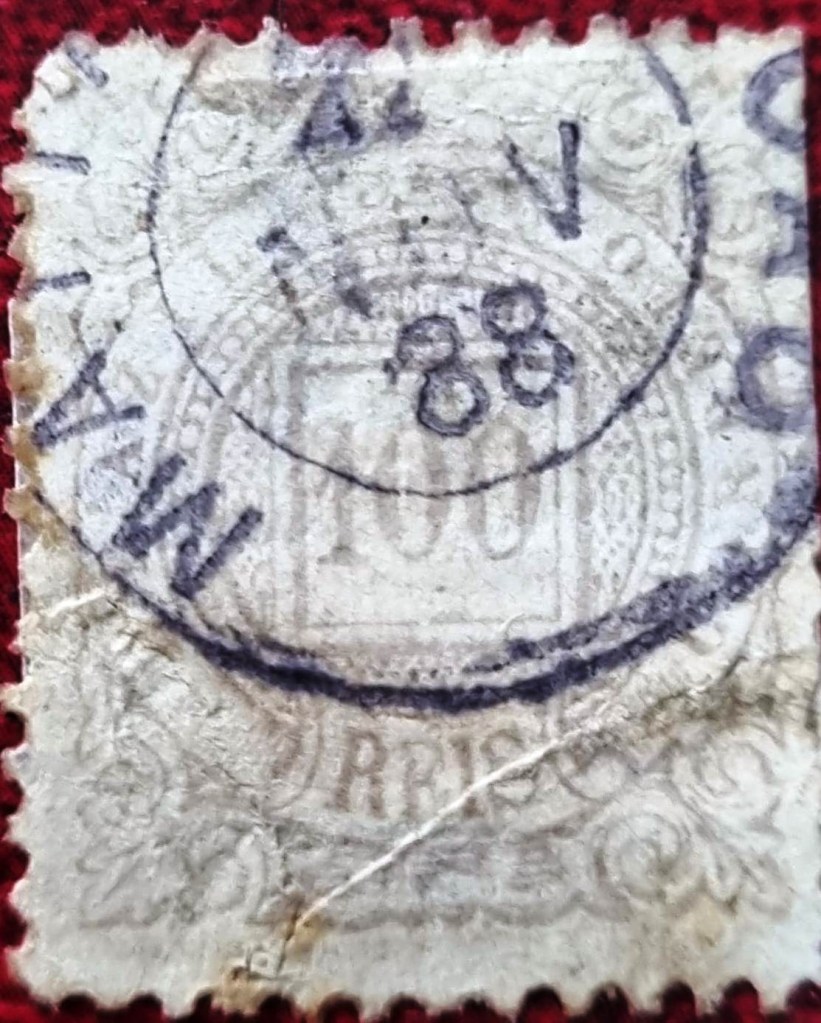
Nova Monteiro writes in Administrações e Agencias Postaes do Brasil Imperio (Brasil Filatelico/RJ, 1934-5; Reprint SPP 1994-1999) that there had been a post office there since March 1863. The only imperial postmark to date is MBA-0475b (illustration by Marcio Duarte):
MBA-0475b (MDu) 1888Atlas do Imperio do Brasil, 1868
Andere Namen: Mata (1931-1938)
Die Freguesia de Senhor do Bonfim da Matta de S. João bestand seit 1761 am Westufer des Jacuípe, 60 Kilometer nördlich der Kolonialhauptstadt Salvador da Bahia. Im April 1846 wurde sie zur Vila erhoben und änderte im Juni 1931 den Ortsnamen zu Mata. Im November 1938 erhielt sie den alten Namen Mata de São João zurück.
Nova Monteiro schreibt in Administrações e Agencias Postaes do Brasil Imperio (Brasil Filatelico/RJ, 1934-5; Reprint SPP 1994-1999), dass es dort seit März 1863 ein Postamt gab. Der bisher einzige kaiserliche Poststempel ist MBA-0475b (Abb. Marcio Duarte):
Villiers de l’Ile Adam: Carta (…) das Provincias de Pernambuco, Alagoas e Sergipe, 1848
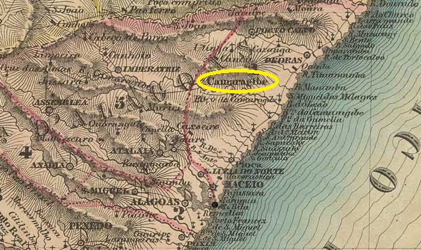
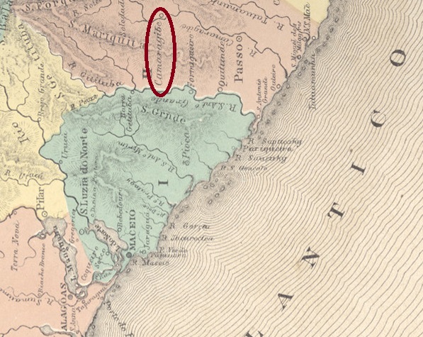
The Freguesia de Bom Jesus do Camaragibe existed since 1749 and belonged to the Vila de Porto Calvo. It was located on the west bank of the Camaragibe, 80 km north of the later provincial capital Maceió. In December 1815, it was assigned to the Vila de Porto de Pedras and in July 1864 to the Vila de Passo do Camaragibe. Matriz do Camaragibe has been an independent municipality since April 1958. The word ‘Matriz’ indicates that the main church was located there. However, the town of Passo do Camaragibe, 12 km downstream, became more important in the 19th century because the river was passable here.
Aldo Cardoso writes in Contribuição para a História dos Correios de Alagoas (Maceió, 1969) that there has been a post office here since 1869. However, a later date, namely October 1879, is more likely, as can be seen from the provincial president’s report.
Relatorio do Presidente da Provincia, 1880
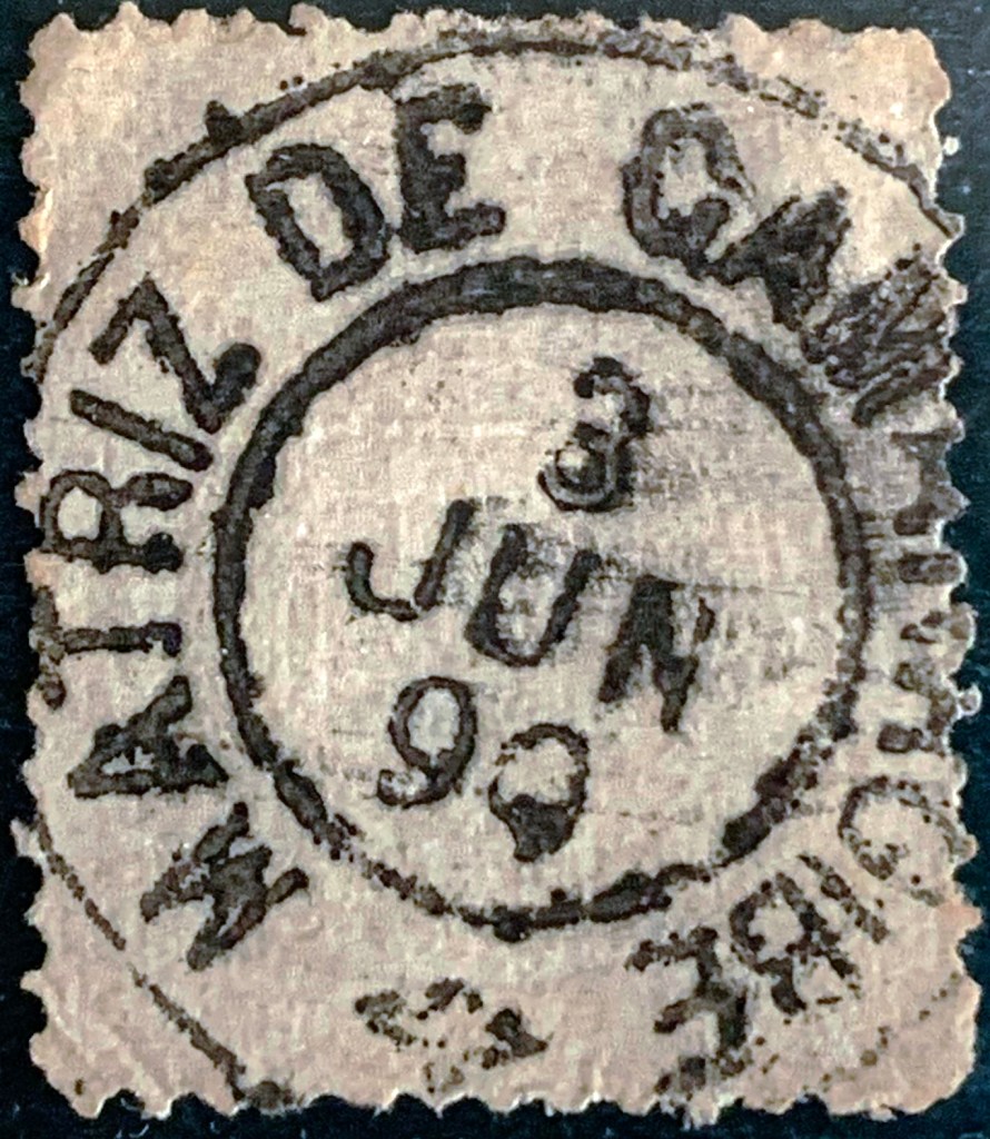
The only imperial postmark to date is MAL-0115b (Fig. Alexandre Andrade):
MAL-0115b (AA) 1887-1890Atlas do Imperio do Brasil, 1868
Die Freguesia de Bom Jesus do Camaragibe bestand seit 1749 und gehörte zur Vila de Porto Calvo. Sie lag am Westufer des Camaragibe, 80 km nördlich der späteren Provinzhauptstadt Maceió. Im Dezember 1815 wurde sie der Vila de Porto de Pedras und im Juli 1864 der Vila de Passo do Camaragibe zugeordnet. Seit April 1958 ist Matriz do Camaragibe ein unabhängiger Município. Das Wort „Matriz” weist darauf hin, dass sich hier die Hauptkirche befand. Allerdings wurde der 12 km flussabwärts gelegene Ort Passo do Camaragibe im 19. Jahrhundert wichtiger, da der Fluss hier passierbar war.
Aldo Cardoso schreibt in Contribuição para a História dos Correios de Alagoas (Maceió, 1969), dass es hier seit 1869 ein Postamt gab. Ein späteres Datum, nämlich Oktober 1879, ist jedoch wahrscheinlicher, wie dem Bericht des Provinzpräsidenten zu entnehmen ist.
Relatorio do Presidente da Provincia, 1880
Der bisher einzige kaiserliche Poststempel ist MAL-0115b (Abb. Alexandre Andrade):
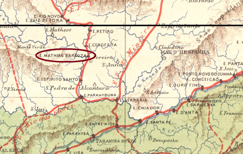
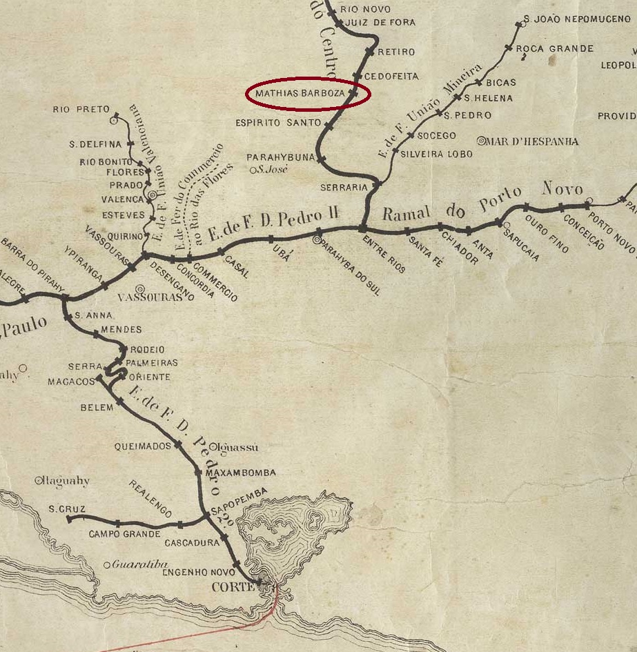
The founder of this settlement on the banks of the Paraibuna River, 260 km south of the provincial capital Ouro Preto, was Colonel Mathias Barbosa Gomes da Silva. In August 1886, it became the Freguesia da vila de Juiz de Fora and in September 1923, it became a Vila in its own Município.
The postal report (Relatorio dos Correios) for the year 1886 shows that there had been a post office there since September 1856. So far, no imperial postmark has been definitively attributed to this Freguesia; however, this handwritten cancellation (illustration: R. Koester in Carimbologia XXVII) probably originates from there.
1866 ff (RK)
In October 1875, the Mathias Barbosa railway station was opened by the E.F. D. Pedro II railway company (Center Line). The railway line became the property of E.F. Central do Brasil in 1889 and belonged to Rede Ferroviária Federal S.A. (estacoesferroviarias.com.br) from 1975 until the line was closed in 1996.
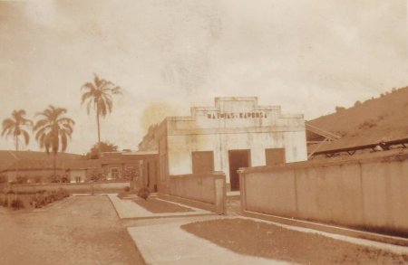
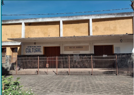
Today, the tracks are still in place and the station building is used as a cultural centre.
Around 1856 (photo: Eurico Pedroso, on estacoesferroviarias.com.br)In January 2021 (photo: Janaina Aquino, on Google Maps).
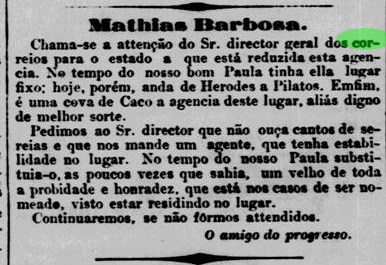
According to Paulo Novaes on agenciaspostais.com.br, there was a post office at the station from November 1875, which was initially administered by the postal directorate in Rio de Janeiro and, from June 1881, by the postal directorate in Ouro Preto. However, the post office in Freguesia remained open until at least mid-1877, as reported in the Rio de Janeiro press.
Jornal do Commercio/RJ, 27 July 1877
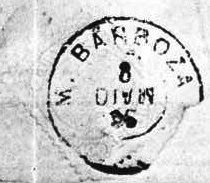
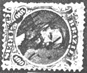
However, this agency was closed by 1879 at the latest, as only the station post office is listed in the Imperial Postal Guide (Guia Postal do Império, Rio de Janeiro, 1880). The oldest postmark from this office is MMG-1575a (see illustration in Koester, op. cit.).
MMG-1575a (RK) 1876ff
This was followed by MMG-1575b (illustration Koester):
MMG-1575b (RK) 1885-1887
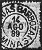
Then came MMG-1575c (Fig. Koester):
MMG-1575c (RK) 1889
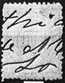
Koester also showed a handwritten cancellation from this station post office:
1885ff (RK)Estações (…) de São Paulo, Rio de Janeiro e Minas Geraes, 1880
Andere Schreibweise: Mathias Barboza
Der Siedlungsgründer dieser Ortschaft am Ufer des Paraibuna, 260 km südlich der Provinzhauptstadt Ouro Preto, war der Oberst Mathias Barbosa Gomes da Silva. Im August 1886 wurde sie zur Freguesia da vila de Juiz de Fora und im September 1923 zur Vila im eigenen Município.
Aus dem Postbericht (Relatorio dos Correios) für das Jahr 1886 geht hervor, dass es dort seit September 1856 ein Postamt gab. Bisher konnte kein kaiserlicher Poststempel mit Sicherheit dieser Freguesia zugeordnet werden; diese handschriftliche Entwertung (Abbildung: R. Koester in Carimbologia XXVII) stammt jedoch vermutlich von dort.
1866 ff (RK)
Im Oktober 1875 wurde der Bahnhof Mathias Barbosa von der Eisenbahngesellschaft E.F. D. Pedro II (Hauptlinie) eröffnet. Die Bahnlinie ging 1889 in den Besitz der E.F. Central do Brasil über und gehörte von 1975 bis zur Streckenstillegung 1996 der Rede Ferroviária Federal S.A. (estacoesferroviarias.com.br).
Heute sind die Gleise noch vorhanden und das Bahnhofsgebäude wird als Kulturzentrum genutzt.
Ca. 1856 (Foto: Eurico Pedroso, auf estacoesferroviarias.com.br)Im Januar 2021 (Foto: Janaina Aquino, auf Google Maps).
Laut Paulo Novaes auf agenciaspostais.com.br gab es seit November 1875 ein Postamt am Bahnhof, das zunächst von der Postdirektion in Rio de Janeiro und ab Juni 1881 von der Postdirektion in Ouro Preto verwaltet wurde. Allerdings blieb das Postamt in der Freguesia zumindest bis Mitte 1877 geöffnet, wie aus der Presse in Rio de Janeiro hervorgeht.
Jornal do Commercio/RJ, 27.07.1877
Diese Agentur wurde jedoch spätestens 1879 geschlossen, da im Kaiserlichen Postführer (Guia Postal do Império, Rio de Janeiro, 1880) nur noch das Bahnhofspostamt aufgeführt wird. Der älteste Poststempel, der von diesem stammt, ist der MMG-1575a (siehe Abbildung bei Koester, op. cit.).
MMG-1575a (RK) 1876ff
Es folgte MMG-1575b (Abb. Koester):
MMG-1575b (RK) 1885-1887
Danach kam MMG-1575c (Abb. Koester):
MMG-1575c (RK) 1889
Koester zeigte auch eine handschriftliche Entwertung aus diesem Bahnhofspostamt: