Categories
Carimbologia E-G

Floresta, Pernambuco (FPE-0260)

Carta da Republica dos Estados Unidos do Brazil, 1892

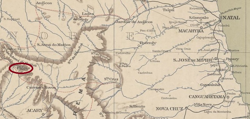
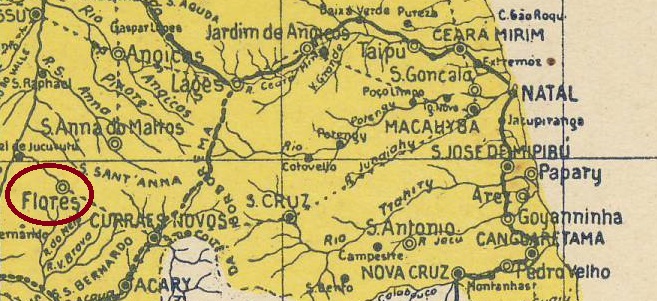
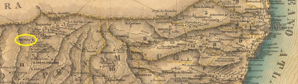
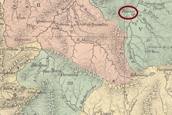
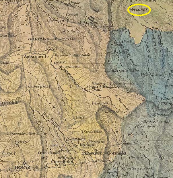
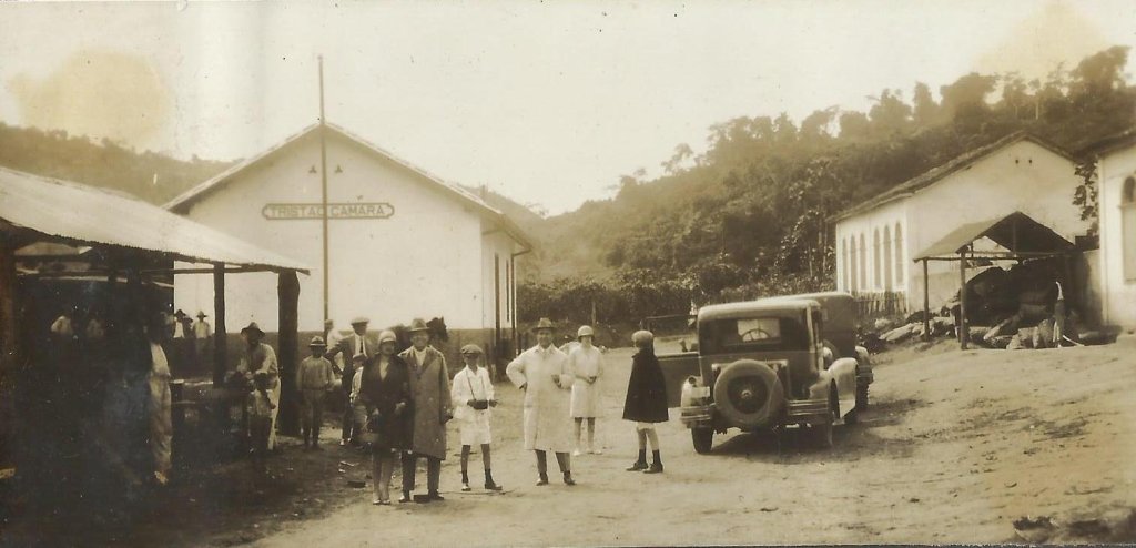
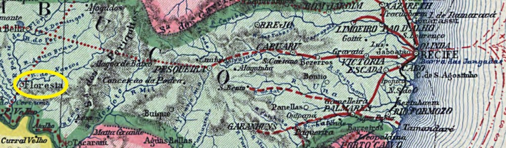
Other names: Fazenda Grande

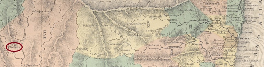
The history of the village is said to have begun in March 1778, when the settlement of Senhor Bom Jesus dos Aflitos da Fazenda Grande started on the west bank of the Pajeú, 440 kilometres west of the future provincial capital Recife. The Freguesia de Fazenda Grande, which belonged to Vila de Flores, was founded there in September 1802. In June 1849, the Freguesia was transferred to the Vila de Tacaratu and became a Vila itself in April 1864 under the place name Floresta. Floresta has been a town since June 1907.

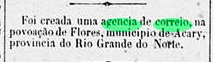
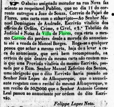
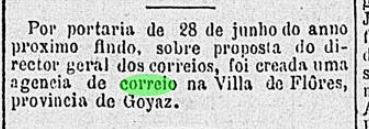
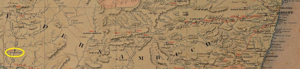
No fewer than four foundation dates have been found for the local post office. In Carimbologia XIX, R. Koester mentions both March 1829 and 1850, which seems less plausible as Floresta was still called Fazenda Grande at the time. This could be a confusion with Flores from Pernambuco (FPE-0255). The directory of imperial post offices (Tabella das Agencias do Correio do Imperio, Rio de Janeiro, 1885) states that the agency had existed since 1855, and this information was adopted in the postal report (Relatorio Postal) of 1886. Even if the Freguesia was already known as Floresta at this time, it is unlikely that it received its post office before the headquarters of Vila de Tacaratu (TPE-0610, P.O. from 1858).

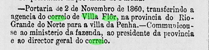
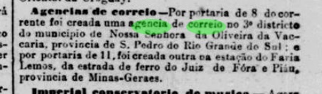
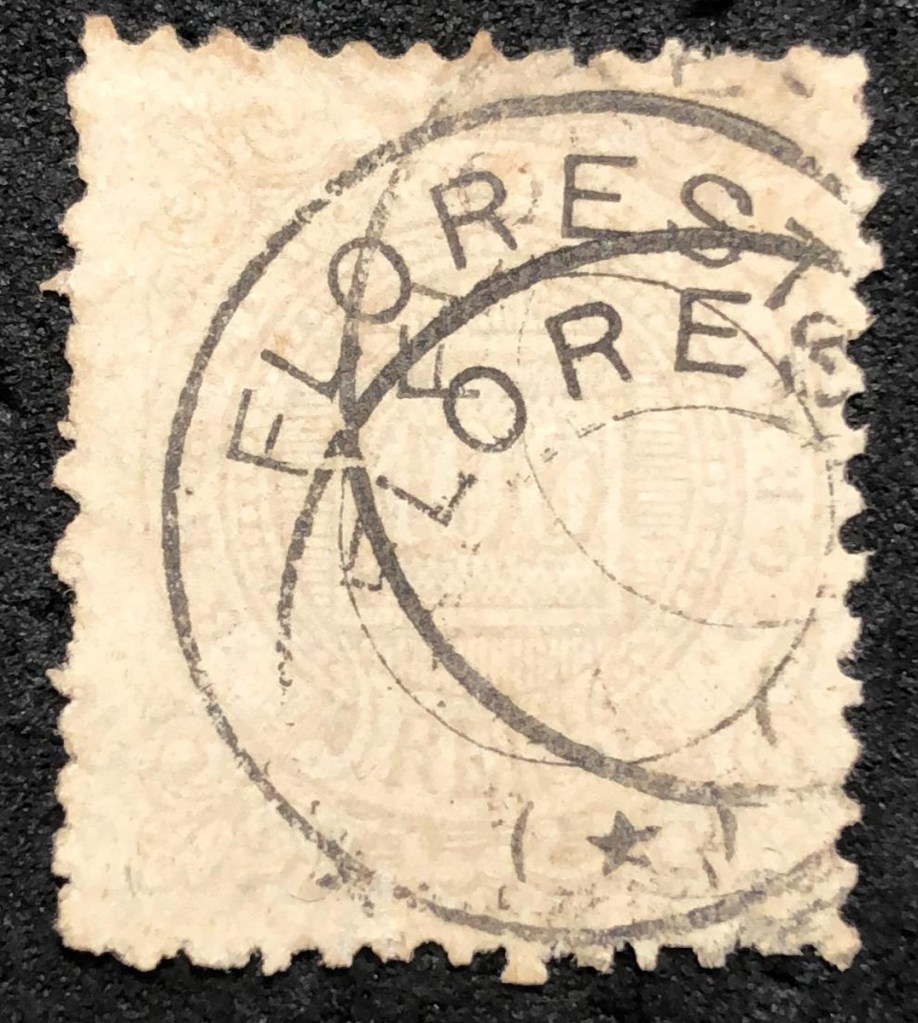
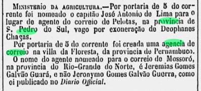
From this point of view, the fourth date of June 1865 remains the most likely for the foundation of the post office, as Nova Monteiro writes in Administrações e Agencias Postaes do Brasil Imperio (Brasil Filatelico/RJ, 1934-5; reprint SPP 1994-1999) and is confirmed by the press in Rio:

Diario do Rio de Janeiro, 07/06/1865

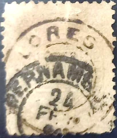
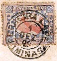
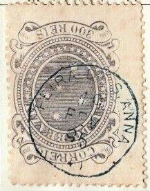
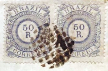
The oldest postmark here so far is the French type FPE-0260b (coll. Marco Morel):

FPE-0260b (ME) 1885ff-1890ff
Carta Corographica da Provincia de Pernambuco, 1880

Andere Namen: Fazenda Grande

Die Geschichte des Ortes soll im März 1778 begonnen haben, als am Westufer des Pajeú, 440 km westlich der späteren Provinzhauptstadt Recife, die Siedlung Senhor Bom Jesus dos Aflitos da Fazenda Grande entstand. Im September 1802 wurde dort die Freguesia de Fazenda Grande gegründet, die zu Vila de Flores gehörte. Im Juni 1849 ging die Freguesia an die Vila de Tacaratu über und wurde im April 1864 unter dem Ortsnamen Floresta selbst zur Vila. Seit Juni 1907 ist Floresta eine Stadt.

Für das örtliche Postamt wurden nicht weniger als vier Gründungsdaten gefunden. R. Koester nennt in Carimbologia XIX sowohl den März 1829 als auch das Jahr 1850 dafür, was weniger plausibel erscheint, da Floresta damals noch Fazenda Grande hieß. Hier könnte eine Verwechslung mit Flores aus Pernambuco (FPE-0255) vorliegen. Im Verzeichnis der kaiserlichen Postämter (Tabella das Agencias do Correio do Imperio, Rio de Janeiro, 1885) ist zu lesen, dass die Agentur seit 1855 bestand, diese Angabe wurde im Postbericht (Relatorio Postal) von 1886 übernommen. Auch wenn die Freguesia zu dieser Zeit bereits als Floresta bekannt war, ist es unwahrscheinlich, dass sie ihr Postamt vor dem Sitz in Vila de Tacaratu (TPE-0610, Postamt ab 1858) erhalten hätte.

So gesehen bleibt das vierte Datum vom Juni 1865 das wahrscheinlichste für die Gründung des Postamtes, wie Nova Monteiro in Administrações e Agencias Postaes do Brasil Imperio (Brasil Filatelico/RJ, 1934-5; Reprint SPP 1994-1999) schreibt und von der Presse in Rio bestätigt wird:

Diario do Rio de Janeiro, 07.06.1865

Der bisher älteste Poststempel hier ist der französische Typ FPE-0260b (Samml. Marco Morel):

FPE-0260b (ME) 1885ff-1890ff
Categories
Carimbologia E-G

Flores, Rio Grande do Norte (FRN-0070)

Sociedade Geológica e Mineralógica, 1910

Other names: Roça do Urubu, Florânia (1943)

The settlement of Flores de Rossurubu is said to have been founded in 1865 on the north bank of the Rossurubu in the Vila de Acary area, 230 kilometres west of the provincial capital of Natal. In 1873 the arraial name was shortened to Flores, in October 1890 the place became the Vila de S. Sebastião de Flores, since December 1943 the Município has been called Florânia.

R. Koester writes in Carimbologia XIX that there has been a post office there since November 1887. This is confirmed by the press in Rio:

Cidade do Rio/RJ 10.11.1887

No postmarks of Flores from the imperial province of Rio Grande do Norte have been seen so far.

Arthur D. Ribeiro: Estado do Rio Grande do Norte, 1923

Andere Namen: Roça do Urubu, Florânia (1943)

1865 soll die Siedlung Flores de Rossurubu am Nordufer des Rossurubu im Gebiet der Vila de Acary, 230 km westlich der Provinzhauptstadt Natal, gegründet worden sein. 1873 wurde der Arraial verkürzt Flores genannt, im Oktober 1890 wurde der Ort zur Vila de S. Sebastião de Flores, seit Dezember 1943 heißt das Município Florânia.

R. Koester schreibt in Carimbologia XIX, dass es dort seit November 1887 ein Postamt gab. Dies wird von der Presse in Rio bestätigt:

Cidade do Rio/RJ 10.11.1887

Bisher wurden keine Poststempel von Flores aus dieser kaiserlichen Provinz Rio Grande do Norte gesehen.

Categories
Carimbologia E-G

Flores, Pernambuco (FPE-0255)

Villiers de l’Ile Adam: Carta (…) das Provincias de Pernambuco, Alagoas e Sergipr, 1848

Other names: Alto Sertão de Pernambuco, Pajeú de Flores

In September 1783, the Freguesia de N. Sra. da Conceição de Flores da Ribeira was founded on the Pajeú, 390 km west of the later provincial capital of Recife. On old maps, the village can be seen on the west bank; today it is on the north bank of the river. In January 1810, it became the Vila de Pajeú de Flores, which was downgraded to a freguesia under the main town of Vila Bela in May 1851, before regaining the status of a villa in May 1858. Flores has been a town since July 1909.

Two foundation dates have been found for the local post office. Once in March 1829, as Nova Monteiro writes in Administrações e Agencias Postaes do Brasil Imperio (Brasil Filatelico/RJ, 1934-5; reprint SPP 1994-1999). Then again in 1850, as can be read both in the directory of imperial post offices (Tabella das Agencias do Correio do Imperio, Rio de Janeiro, 1885) and in the postal report (Relatorio Postal, Rio de Janeiro) for 1886.

Both dates are disputed. R. Koester (Carimbologia XIX) doubts the earlier date. However, it seems that there was regular mail to and from Flores at least in October 1833:

Diario de Pernambuco, 15 Oct. 1833

The fact that there were regular postal lines to Flores until 1849 speaks against the establishment of a second agency in 1850:

Diario de Pernambuco, 11/08/1849

However, there was a political uprising in the region in 1847-1849, which may have affected postal traffic. In any case, the only postmark from the imperial era to date is the French type FPE-0255b (fig. José L. Fevereiro):

FPE-0255b (JLF) 1883ff-1885ff
Atlas do Imperio do Brasil, 1868

Andere Namen: Alto Sertão de Pernambuco, Pajeú de Flores

Im September 1783 wurde die Freguesia de N. Sra. da Conceição de Flores da Ribeira am Pajeú, 390 km westlich der späteren Provinzhauptstadt Recife, gegründet. Auf alten Karten ist der Ort am Westufer zu sehen, heute liegt er am Nordufer des Flusses. Im Januar 1810 wurde es zur Vila de Pajeú de Flores, die im Mai 1851 zur Freguesia unter dem Hauptort Vila Bela herabgestuft wurde, bevor sie im Mai 1858 wieder den Status einer Villa erhielt. Seit Juli 1909 ist Flores eine Stadt.

Für das örtliche Postamt wurden zwei Gründungsdaten gefunden. Einmal im März 1829, wie Nova Monteiro in Administrações e Agencias Postaes do Brasil Imperio (Brasil Filatelico/RJ, 1934-5; Nachdruck SPP 1994-1999) schreibt. Dann wieder 1850, wie sowohl im Verzeichnis der kaiserlichen Postämter (Tabella das Agencias do Correio do Imperio, Rio de Janeiro, 1885) als auch im Postbericht (Relatorio Postal, Rio de Janeiro) für 1886 zu lesen ist.

Beide Daten sind umstritten. R. Koester (Carimbologia XIX) bezweifelt das frühere Datum. Es scheint jedoch, dass es zumindest im Oktober 1833 regulär Post von und nach Flores gab:

Diario de Pernambuco, 15.10.1833

Gegen eine zweite Agenturgründung 1850 spricht, dass bis 1849 regelmäßige Postlinien nach Flores bestanden:

Diario de Pernambuco, 11.08.1849

Allerdings gab es 1847-1849 einen politischen Aufstand in der Region, der den Postverkehr beeinträchtigt haben dürfte. Jedenfalls ist der bisher einzige Poststempel aus der Kaiserzeit der französische Typ FPE-0255b (Abb. José L. Fevereiro):

FPE-0255b (JLF) 1883ff-1885ff
Categories
Carimbologia E-G

Flores, Goiás (FGO-0070)

Atlas do Imperio do Brasil, 1868

Other names: Urutágua, Flores de Goiás (1963)

The Freguesia de N. Sra. do Rosário de Flores was founded in July 1835, belonged to the Vila do Forte and was located on the east bank of the Paranã, 540 kilometres east of the provincial capital Goyaz (today: Goiás Velho). In July 1850, the village was elevated to a Vila before a long period of political instability began, which only ended in July 1907 when the village became a Distrito in the Município de Sitio d’Abadia. This was followed by two changes of the town’s name: in December 1943 to Urutágua and in November 1963, when it was elevated to the Município de Flores de Goiás.

The local post office was founded at least twice. First in March 1829, as Nova Monteiro wrote in Administrações e Agencias Postaes do Brasil Imperio (Brasil Filatelico/RJ, 1934-5; reprint SPP 1994-1999). Then again in June 1882, as reported by the Rio press:

Gazeta de Noticias/RJ, 28/03/1883

As the agency is also mentioned in the imperial postal guide (Guia Postal do Império do Brazil, Rio de Janeiro, 1880), its closure cannot have taken place before 1880.

No imperial postmarks from Flores in the province of Goiás are known to date.

Villiers de l’Ile Adam: Carta (…) da Provinica de Goyaz, 1849

Andere Namen: Urutágua, Flores de Goiás (1963)

Die Freguesia de N. Sra. do Rosário de Flores wurde im Juli 1835 gegründet, gehörte zur Vila do Forte und lag am Ostufer des Paranã, 540 km östlich der Provinzhauptstadt Goyaz (heute: Goiás Velho). Im Juli 1850 wurde der Ort zur Vila erhoben, bevor eine lange Zeit der politischen Instabilität begann, die erst im Juli 1907 endete, als der Ort zum Distrito im Município de Sitio d’Abadia wurde. Es folgten zwei Änderungen des Ortsnamens: im Dezember 1943 in Urutágua und im November 1963, als die Erhebung zum Município de Flores de Goiás stattfand.

Das örtliche Postamt wurde mindestens zweimal gegründet. Zuerst im März 1829, wie Nova Monteiro in Administrações e Agencias Postaes do Brasil Imperio (Brasil Filatelico/RJ, 1934-5; Nachdruck SPP 1994-1999) schrieb. Dann wieder im Juni 1882, wie die Presse von Rio berichtete:

Gazeta de Noticias/RJ, 28.03.1883

Da die Agentur auch im kaiserlichen Postführer (Guia Postal do Império do Brazil, Rio de Janeiro, 1880) erwähnt wird, kann ihre Schließung nicht vor 1880 erfolgt sein.

Bisher sind keine kaiserlichen Poststempel aus Flores in der Provinz Goiás bekannt.

Categories
Carimbologia E-G

Flores (train station/Bahnhof), Rio de Janeiro (FRJ-0550)

Estações (…) do Rio de Janeiro, São Paulo e Minas Geraes, 1880

See also Santa Ignacia(Estação), Rio de Janeiro (SRJ-1665)

Flores station was inaugurated in October 1879 by the Cia. Estrada de Ferro Valenciana in the municipality of Valença, over 150 km northwest of Rio de Janeiro. Three years later the station name was changed to Santa Ignacia. From 1910 until operation end in 1970 the railway was managed by the Estrada de Ferro Central do Brasil. Now the tracks have been removed, and the station house is a private habitation (estacoesferroviarias.com.br).

In 2002 (Photo by Jorge A. Ferreira Jr., on estacoesferroviarias.com.br)

According to Paulo Novaes (agenciaspostais.com.br), the station post office was created in July 1880, still under the name of Flores, and switched to Santa Ignacia from June 1882 on. One Flores cancel is known: FRJ-0550a (Image by Felipe Piccinini):

FRJ-0550a (FP) 1880-1882

For cancels with Santa Ignacia see SRJ-1665.

Almanak Laemmert, 1892

Siehe auch Santa Ignacia(Estação), Rio de Janeiro (SRJ-1665)

Der Bahnhof Flores wurde im Oktober 1879 durch die Cia. Estrada de Ferro Valenciana eingeweiht und lag im Município vom Valença, über 150 km nordwestlich von Rio de Janeiro entfernt. Drei Jahre später wurde der Bahnhof zu Santa Ignacia umbenannt. Von 1910 bis Betriebsende 1970 stand die Linie unter der Kontrolle der Estrada de Ferro Central do Brasil. Nun sind die Schienen entfernt worden, und das Bahnhofsgebäude dient als Wohnung (estacoesferroviarias.com.br).

2002 (Foto Jorge A. Ferreira Jr., auf estacoesferroviarias.com.br)

Laut Paulo Novaes (agenciaspostais.com.br) entstand das Bahnhofspostamt im Juli 1880, noch unter den Namen Flores, und wechselte zu Santa Ignacia ab Juni 1882. Ein Stempel der Kaiserzeit ist überliefert: FRJ-0550a (Abb. Felipe Piccinini):

FRJ-0550a (FP) 1880-1882

Für Poststempel mit Santa Ignacia siehe SRJ-1665.

Categories
Carimbologia E-G

Flor, Rio Grande do Norte (FRN-0065)

Atlas do Imperio do Brasil, 1868

Other names: Gramació

See also Villa Flor (VRN-0240)

This village was originally an Indian settlement called Gramació, situated on the north bank of the Curimataú River, more than 80 km south of the future provincial capital Natal. In May 1755, the village rose to the status of a vila, but three years later it was moved to the neighbouring village of Canguaretama. In November 1892, Villa Flor became a district of Canguaretama and only regained political independence as a município in December 1963.

As Nova Monteiro writes in Administrações e Agencias Postaes do Brasil Imperio (Brasil Filatelico/RJ, 1934-5; Reprint SPP 1994-1999), there was a post office there as early as April 1818. With the move to Penha de Canguaretama (1858), the postal agency also moved there two years later, according to the capital’s official press:

Expediente do Ministerio do Imperio, 02.11.1860

Unfortunately, no 19th century postmark from this locality has been seen so far.

Villiers de l’Ile Adam: Carta (…) das Provincias do Rio Grande do Norte e Parahiba, 1848

Andere Namen: Gramació, Flor

Siehe auch Villa Flor (VRN-0240)

Diese Ortschaft war ursprünglich eine Indianersiedlung namens Gramació, die am Nordufer des Flusses Curimataú lag, über 80 km südlich der künftigen Provinzhauptstadt Natal entfernt. Im Mai 1755 stieg der Ort zur Vila auf, die aber drei Jahre später zum Nachbarort Canguaretama verlegt wurde. Im November 1892 wurde Villa Flor ein Distrikt von Canguaretama und erhielt erst im Dezember 1963 die politische Selbständigkeit als Município wieder.

Wie Nova Monteiro in Administrações e Agencias Postaes do Brasil Imperio (Brasil Filatelico/RJ, 1934-5; Reprint SPP 1994-1999) schreibt, gab es dort ein Postamt bereits ab April 1818. Mit dem Umzug nach Penha de Canguaretama (1858) zog die Postagentur zwei Jahre später auch dorthin, wie die Amtspresse der Hauptstadt berichtet:

Expediente do Ministerio do Imperio, 02.11.1860

Leider wurde bisher kein Poststempel des 19. Jahrhunderts aus dieser Ortschaft gesehen.

Categories
Carimbologia E-G

Figueira (train station/Bahnhof), Rio de Janeiro (FRJ-0500)

Almanak Laemmert, 1892

Other names: Est. Tristão Câmara (ca. 1935)

Figueira station was opened in November 1886 by the railway company E.F. do Grão-Pará (Rio Preto Branch) and was located on the south bank of the Rio Preto in the Município Petrópolis, 110 km north of the capital Rio de Janeiro. The name comes from the nearby Fazenda da Figueira. The line belonged to E.F. Leopoldina from 1890 until it was closed in 1947. From around 1935, the station was called Tristão Câmara, after the owner of the Fazenda da Figueira since 1853. Around 1945, the entire area around the station was flooded during the construction of a dam. Since December 1987, the lost railway station has been in the Município S. José do Vale do Rio Preto.

Around 1935 (Photo: N.N. on estacoesferroviarias.com.br)

As Paulo Novaes writes in agenciaspostais.com.br, there had been a post office in the station since June 1886 with the imperial postmark FRJ-0500a (ill. by R. Koester in Carimbologia XIX):

FRJ-0500a (RK) 1887-1894ff
agenciaspostais.com.br

Andere Namen: Est. Tristão Câmara (ca. 1935)

Der Bahnhof Figueira wurde im November 1886 von der Eisenbahngesellschaft E.F. do Grão-Pará (Rio Preto-Abzweigung) eröffnet und lag am Südufer des Rio Preto im Município Petrópolis, 110 km nördlich der Hauptstadt Rio de Janeiro. Der Name stammt von der nahe gelegenen Fazenda da Figueira. Die Strecke gehörte von 1890 bis zu ihrer Stilllegung 1947 der E.F. Leopoldina. Ab etwa 1935 hieß der Bahnhof Tristão Câmara, nach dem Besitzer der Fazenda da Figueira seit 1853. Um 1945 wurde das gesamte Gebiet um den Bahnhof beim Bau eines Staudamms überflutet. Seit Dezember 1987 befindet sich der verschwundene Bahnhof im Município de S. José do Vale do Rio Preto.

Um 1935 (Foto: N.N. auf estacoesferroviarias.com.br)

Wie Paulo Novaes in agenciaspostais.com.br schreibt, gab es im Bahnhof seit Juni 1886 ein Postamt mit dem kaiserlichen Poststempel FRJ-0500a (Abb. R. Koester in Carimbologia XIX):

FRJ-0500a (RK) 1887-1894ff
Categories
Carimbologia E-G

Ferreira Lage (train station/Bahnhof), Minas Gerais (FMG-1175)

Estrada de Ferro Leopoldina

Other names: Est. Sant’Anna, Desembargador Faria Lemos

See also Faria Lemos (Est. E.F. Leopoldina, FMG-1170), Faria Lemos (Est. E.F. Juiz de Fora e Piau), (FMG-0970)

This station in the imperial province of Minas Gerais was opened in 1884 as Sant’Anna station by the railway company E.F. Juiz de Fora e Piau in the Município de Juiz de Fora, 230 km south of the provincial capital Ouro Preto. Around 1887, the station was renamed to Faria Lemos:

Pharol, 03/05/1887

In 1888, the railway line was purchased by the 1974 E.F. Leopoldina and remained in its possession until it was closed in 1974. As the Leopoldina company already owned a Faria Lemos station (FMG-1170), the other station had to be renamed Ferreira Lage again, this time in honour of the entrepreneur Mariano Procópio Ferreira Lage (1821-1872), who had co-financed the E.F. Juiz de Fora e Piau.

Mariano Procópio Ferreira Lage (Wikipedia)
Est. Ferreira Lage 1915 (Photo: Abilio Esteves, in Album de Juiz de Fora)

Today, neither the tracks nor the station building exist.

According to the Rio press, there was a post office at the station from October 1887:

Jornal do Commercio/RJ, 12/10/1887

The oldest postmark under Ferreira Lage so far is FMG-1175a (ill. José Luiz Fevereiro)

FMG-1175a (JLF) 1892

For postmarks with Faria Lemos see FMG-0970 and FMG-1170.

Estado de Minas Geraes, 1910

Andere Namen: Est. Sant’Anna, Desembargador Faria Lemos

Siehe auch Faria Lemos (Est. E.F. Leopoldina, FMG-1170), Faria Lemos (Est. E.F. Juiz de Fora e Piau), (FMG-0970)

Dieser Bahnhof wurde 1884 als Bahnhof Sant’Anna von der Eisenbahngesellschaft E.F. Juiz de Fora e Piau eröffnet und lag im Município de Juiz de Fora, 230 km südlich der Provinzhauptstadt Ouro Preto. Um 1887 wurde die Station in Faria Lemos umbenannt:

Pharol, 03.05.1887

1888 wurde die Bahnlinie von der 1974 E.F. Leopoldina gekauft und blieb bis zu ihrer Stilllegung 1974 in deren Besitz. Da die Gesellschaft Leopoldina bereits eine Station Faria Lemos (FMG-1170) besaß, musste die Station erneut umbenannt werden, diesmal zu Ehren des Unternehmers Mariano Procópio Ferreira Lage (1821-1872), der die E.F. Juiz de Fora e Piau mitfinanziert hatte.

Mariano Procópio Ferreira Lage (Wikipedia)
Est. Ferreira Lage 1915 (Foto: Abilio Esteves, im Album de Juiz de Fora)

Heute existieren weder die Gleise noch das Bahnhofsgebäude.

Wie der Presse von Rio zu entnehmen ist, befand sich seit Oktober 1887 ein Postamt am Bahnhof:

Jornal do Commercio/RJ, 12.10.1887

Der bisher älteste Poststempel mit Ferreira Lage ist FMG-1175a (JLF)

FMG-1175a (JLF) 1892

Für Poststempel mit Faria Lemos siehe FMG-0970 und FMG-1170.

Categories
Carimbologia E-G

Fernando de Noronha, Pernambuco (FPE-0250)

Atlas do Imperio do Brasil, 1868

Fernando de Noronha consists of 21 islands in the Atlantic Ocean, 550 kilometres north-east of the state capital Recife. It has served as a prison since around 1740, as a military territory (Território federal militar) since 1942 and has been a district of the state of Pernambuco since October 1988. The name comes from Fernão de Loronha (1470-1540), a converted Jew from Portuguese nobility who helped to finance the colonisation of the island.

Fernão de Loronha (N.N.- XVII century)

As Nova Monteiro writes in Administrações e Agencias Postaes do Brasil Imperio (Brasil Filatelico/RJ, 1934-5; reprint SPP 1994-1999), it was decided as early as October 1858 to set up a local post office. However, it was not until January 1861 that the agency was opened at the local apothecary.

Diário de Pernambuco, 08.02.1861

The first postmark has not yet been found. The French type FPE-0250b (Fig. Felipe Piccinini) is known:

 FPE-0250b (FP) 1882ff-1890ff
Carta da Republica dos Estados Unidos do Brazil, 1892

Der Archipel Fernando de Noronha besteht aus 21 Inseln im Atlantischen Ozean, 550 km nordöstlich der Landeshauptstadt Recife. Seit ca. 1740 diente er als Gefängnis, seit 1942 als Militärgebiet (Território federal militar) und seit Oktober 1988 ist er ein Distrito des Bundesstaates Pernambuco. Der Name stammt von Fernão de Loronha (1470-1540), einem konvertierten Juden aus portugiesischem Adel, der die Besiedlung der Insel mitfinanzierte.

Fernão de Loronha (N.N.- XVII Jahrhundert)

Wie Nova Monteiro in Administrações e Agencias Postaes do Brasil Imperio (Brasil Filatelico/RJ, 1934-5; Nachdruck SPP 1994-1999) schreibt, wurde bereits im Oktober 1858 beschlossen, vor Ort ein Postamt einzurichten. Es dauerte jedoch bis Januar 1861, bis die Agentur beim örtlichen Apotheker in Betrieb genommen wurde.

Diário de Pernambuco, 08.02.1861

Der erste Poststempel ist noch nicht gefunden worden. Bekannt ist der französische Typ FPE-0250b (Abb. Felipe Piccinini):

 FPE-0250b (FP) 1882ff-1890ff
Categories
Carimbologia E-G

Feira (de Sant’Anna), Bahia (FBA-0365)

Villiers de l’Ile Adam: Carta (…) da Provincia da Bahia, 1848

Today’s city of Feira de Santana, with over 600,000 inhabitants, was originally the Fazenda Sant’Anna dos Olhos d’Água in the Vila de Cachoeira area, 115 km north-west of the capital Salvador da Bahia. It became a Freguesia in 1696, a Vila in November 1832 and the Cidade Commercial da Feira de Sant’Anna in June 1873.

Two creation dates have been recorded for the local post office. Once in March 1836, as Nova Monteiro wrote in Administrações e Agencias Postaes do Brasil Imperio (Brasil Filatelico/RJ, 1934-5; reprint SPP 1994-1999). Then again in March 1846, according to R. Koester’s Carimbologia XIX. Seen in this light, only a few 19th century postmarks are known for this important city.

First and foremost is the pre-philatelic FBA-0365a, which was given the no. P-BA-07 in the RHM catalogue:

FBA-0365a (RK/RHM P-BA-07) 1839-1842

This was followed by a long period without known cancellations until FBA-0365b (fig. R. Koester, op. cit.) appeared:

FBA-0365b (RK) 1884-1901

Towards the end of the Empire, the French type FBA-0365c (ill. from the Internet) was added:

FBA-0365c (EB) 1895

At least we still know of a mute cancel (illustration by Roberto Assef Jr.) from 1888:

1888 (RA)
Atlas do Imperio do Brasil, 1868

Die heutige Stadt Feira de Santana mit über 600.000 Einwohnern war ursprünglich die Fazenda Sant’Anna dos Olhos d’Água im Gebiet der Vila de Cachoeira, 115 km nordwestlich der Hauptstadt Salvador da Bahia. 1696 wurde sie zur Freguesia, im November 1832 zur Vila und im Juni 1873 zur Cidade Commercial da Feira de Sant’Anna.

Für das örtliche Postamt sind zwei Gründungsdaten überliefert. Einmal im März 1836, wie Nova Monteiro in Administrações e Agencias Postaes do Brasil Imperio (Brasil Filatelico/RJ, 1934-5; Nachdruck SPP 1994-1999) schrieb. Dann noch einmal im März 1846, nach R. Koesters Carimbologia XIX. So gesehen sind nur wenige Poststempel aus dem 19. Jahrhundert für diese bedeutende Stadt bekannt.

An erster Stelle ist der vorphilatelistische FBA-0365a zu nennen, der im RHM-Katalog die Nr. P-BA-07 erhielt:

FBA-0365a (RK/RHM P-BA-07) 1839-1842

Es folgte eine lange Zeit ohne bekannte Stempel, bis FBA-0365b (Abb. R. Koester, op. cit.) erschien:

FBA-0365b (RK) 1884-1901

Gegen Ende des Kaiserreichs kam der französische Typ FBA-0365c (Abb. aus dem Internet) hinzu:

FBA-0365c (EB) 1895

Immerhin kennen wir noch einen stummen Stempel (Abb. Roberto Assef Jr.) von 1888:

1888 (RA)