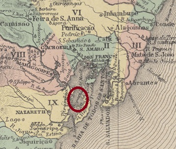
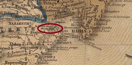
The Freguesia de Santissimo Sacramento de Itaparica was founded in January 1815, belonged to the city of Salvador da Bahia and was idyllically situated on the island of Itaparica in the Bay of All Saints, 30 kilometres west of the capital. Itaparica became a vila in October 1831 and a city in October 1890. The term comes from the Tupi-Guarani and means stone wall.
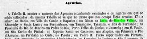
Nova Monteiro writes in Administrações e Agencias Postaes do Brasil Imperio (Brasil Filatelico/RJ, 1934-5; reprint SPP 1994-1999) that there had been a post office there since October 1858. This is confirmed by the following report from the postal General Directorate:
Relatorio da Directoria Geral dos Correios, 1858
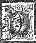
The only imperial postmark to date is IBA-0405b (fig. R. Koester in Carimbologia XXIV):
IBA-0405b (RK) 1877ff-1895Villiers de l’Ile Adam: Carta (…) da Provincia da Bahia , 1848
Die Freguesia de Santissimo Sacramento de Itaparica wurde bereits im Januar 1815 gegründet, gehörte zur Stadt Salvador da Bahia und lag idyllisch auf der Insel Itaparica in der Allerheiligenbucht, 30 km westlich der Hauptstadt. Itaparica wurde im Oktober 1831 zur Vila und im Oktober 1890 zur Stadt erhoben. Der Begriff stammt aus dem Tupi-Guarani und bedeutet Steinmauer.
Nova Monteiro schreibt in Administrações e Agencias Postaes do Brasil Imperio (Brasil Filatelico/RJ, 1934-5; Reprint SPP 1994-1999), dass es dort seit Oktober 1858 ein Postamt gab. Dies wird durch den folgenden Bericht der Generaldirektion der Post bestätigt:
Relatorio da Directoria Geral dos Correios, 1858
Der bisher einzige kaiserliche Poststempel ist IBA-0405b (Abb. R. Koester in Carimbologia XXIV):
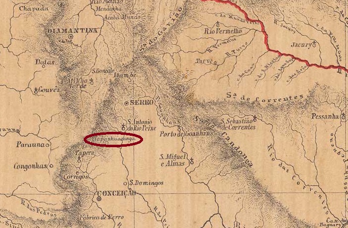
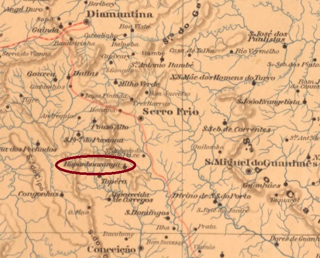
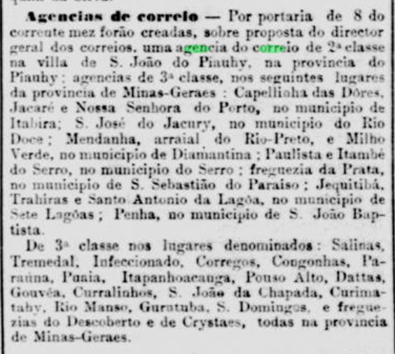
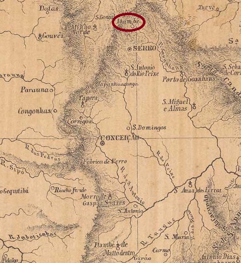
Since December 1880, Itapanhoacanga was a distrito of the Vila do Serro, located 300 kilometres north of the provincial capital Ouro Preto. In October 1881 it was elevated to the Freguesia de S. José de Itapanhoacanga, which has been a distrito of the Município de Alvorada de Minas since December 1962. The name Tupi-guarani, which sounds strange even to Brazilian ears, means negro head stone and refers to the abundant iron ore available at the time.
The Rio press reports that there had been a post office there since November 1881:
Jornal do Commercio/RJ, 08/11/1881
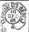
The only postmark from the 19th century to date, IMG-3675b (illustration by Claudio Coelho), already shows dates from the Republic:
IMG-3675b (CC) 1897-1905Estado de Minas Geraes, 1910
Andere Namen: Tapanhoacanga
Seit Dezember 1880 war Itapanhoacanga ein Distrito der Vila do Serro, 300 km nördlich der Provinzhauptstadt Ouro Preto gelegen. Im Oktober 1881 erfolgte die Erhebung zur Freguesia de S. José de Itapanhoacanga, die seit Dezember 1962 ein Distrito des Município de Alvorada de Minas ist. Der selbst für brasilianische Ohren merkwürdig klingende Name der Tupi-guarani bedeutet Negerkopfstein und bezieht sich auf das damals reichlich vorhandene Eisenerz.
Die Presse von Rio berichtet, dass es dort seit November 1881 ein Postamt gab:
Jornal do Commercio/RJ, 08.11.1881
Der bisher einzige Poststempel aus dem 19. Jahrhundert IMG-3675b (Abb. Claudio Coelho) zeigt bereits Daten aus der Republik:
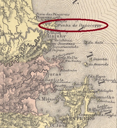
Villiers de l’Ile Adam: Carta (…) da Provincia de Santa Catarina, 1848
Other names: Penha de Itapocoroí, Penha (1938)
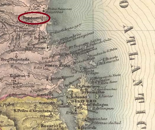
The Freguesia de N. Sra. da Penha do Itapocoroy has existed since March 1839, it belonged to the Vila de S. Francisco and was a nautic base (armação) on the beach, 120 km north of the provincial capital Desterro (today: Florianópolis). In April 1859 the Freguesia was transferred to the Vila de Itajaí, in March 1938 the place name was simplified to Distrito de Penha. Penha has been an independent municipality since June 1958.
Two dates have been found for the foundation of the local post office. The first is around 1840, as can be seen in a report from the Imperial Ministry from May of the following year:
Relatorio do Ministerio do Imperio, 05/1841
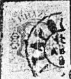
The agency was closed by 1856 at the latest, as it is no longer mentioned in the postal guide (Guia do Correio do Brasil) of 1857. The second opening followed the decision of September 1875, as R. Koester (Carimbologia XXIV) writes. The only imperial postmark to date is ISC-0135b (fig. Koester, op. cit.):
ISC-0135b (RK) 1882ffAtlas do Imperio do Brasil, 1868
Andere Namen: Penha de Itapocoroí, Penha (1938)
Seit März 1839 bestand die Freguesia de N. Sra. da Penha do Itapocoroy, sie gehörte zur Vila de S. Francisco und war ein Schifffahrts-Stützpunkt (armação) am Strand, 120 km nördlich der Provinzhauptstadt Desterro (heute: Florianópolis) Im April 1859 ging die Freguesia an die Vila de Itajaí über, im März 1938 wurde der Ortsname in Distrito de Penha vereinfacht. Seit Juni 1958 ist Penha ein eigenständiges Munizip.
Für die Gründung des örtlichen Postamtes wurden zwei Daten gefunden. Zum ersten Mal um 1840, wie aus einem Bericht des kaiserlichen Ministeriums vom Mai des folgenden Jahres hervorgeht:
Relatorio do Ministerio do Imperio, 05/1841
Die Agentur wurde spätestens 1856 geschlossen, da sie im Postführer (Guia do Correio do Brasil) des folgenden Jahres nicht mehr erwähnt wird. Die zweite Eröffnung folgte auf den Beschluss vom September 1875, wie R. Koester (Carimbologia XXIV) schreibt. Der bisher einzige kaiserliche Poststempel ist ISC-0135b (Abb. Koester, op. cit.):
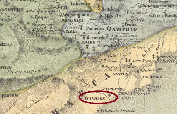
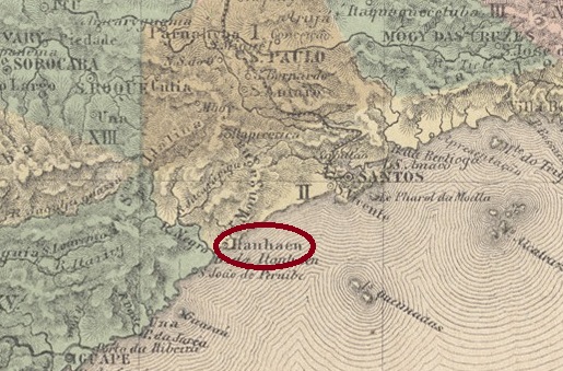
Villiers de l’Ile Adam: Carta (…) da Provincia de São Paulo, 1847
This place is one of the oldest in Brazil. The settlement was founded as early as April 1532 at the mouth of the Itanhaém River into the Atlantic Ocean, 110 kilometres south of the later provincial capital of São Paulo, which was elevated to the Freguesia de N. Sra. da Conceição do Itanhaém in 1549 and to a Vila in April 1561. The name of the municipality was shortened to Itanhaém in November 1906 and it became a town in December 1906.
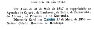
Three periods of operation for the local post office in the Empire have been established, although it is still unknown when the first one began. It ended in May 1847, according to the report of the Ministry of the Empire:
Relatorio do Ministerio do Imperio, 1847
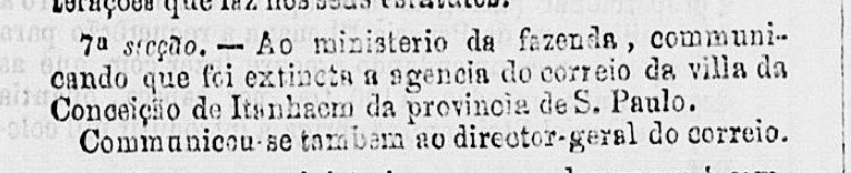
Nova Monteiro writes in Administrações e Agencias Postaes do Brasil Imperio (Brasil Filatelico/RJ, 1934-5; reprint SPP 1994-1999) about a reopening of the agency in February 1849, which was closed again a good ten years later:
Expediente do Ministerio do Imperio, 31/12/1859
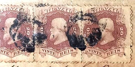
The third operating period began in 1869, as can be seen from the list of imperial post offices (Tabella das Agencias do Correio do Imperio, Rio de Janeiro, 1885). The first postmark has not yet been found; of the second, the French type ISP-0610b (collect. Fuad Ferreira Fo.), only one specimen from 1872 is known:
ISP-0610b (FF) 1872
There is also a mute cancellation on the same cover:
1872 (FF)
The following cancel is also rare, ISP-0610c was introduced by R. Koester in Carimbologia XXIV:
ISP-0610c (RK) 1887Atlas do Imperio do Brasil, 1868
Dieser Ort ist einer der ältesten Brasiliens. Bereits im April 1532 wurde die Siedlung an der Mündung des Flusses Itanhaém in den Atlantik gegründet, 110 km südlich der späteren Provinzhauptstadt São Paulo, die 1549 zur Freguesia de N. Sra. da Conceição do Itanhaém und im April 1561 zur Vila erhoben wurde. Der Name der Gemeinde wurde im November 1906 auf Itanhaém verkürzt, seit Dezember 1906 ist es eine Stadt.
Drei Betriebsperioden für das örtliche Postamt im Kaiserreich festgestellt, wobei noch unbekannt ist, wann die erste begann. Sie endete im Mai 1847, wie aus dem Bericht des Reichsministeriums hervorgeht:
Relatorio do Ministerio do Imperio, 1847
Nova Monteiro schreibt in Administrações e Agencias Postaes do Brasil Imperio (Brasil Filatelico/RJ, 1934-5; Nachdruck SPP 1994-1999) über eine Wiedereröffnung der Agentur im Februar 1849, die gut zehn Jahre später wieder geschlossen wurde:
Expediente do Ministerio do Imperio, 31.12.1859
Die dritte Betriebsperiode begann 1869, wie aus dem Verzeichnis der kaiserlichen Postämter (Tabella das Agencias do Correio do Imperio, Rio de Janeiro, 1885). Der erste Poststempel wurde noch nicht gefunden, vom zweiten, dem französischen Typ ISP-0610b (Samml. Fuad Ferreira Fo.) ist nur ein Exemplar aus dem Jahr 1872 bekannt:
ISP-0610b (FF) 1872
Auf demselben Beleg befindet sich auch ein stummer Stempel:
1872 (FF)
Der folgende Stempel ist ebenfalls selten, ISP-0610c wurde von R. Koester in Carimbologia XXIV vorgestellt:
Carta Corographica da Provincia de Pernambuco, 1880
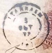
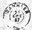
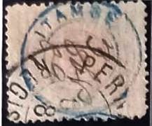
Other names: També (1938-1975)
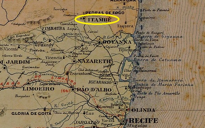
The Freguesia de N. Sra. do Desterro do Itambé had existed since January 1789. It belonged to the Vila de Goyanna and was located on the provincial border with Paraíba, opposite Pedras de Fogo, 90 kilometres north of the capital Recife. It was declared a vila in May 1867 and a town in February 1879, which was called També between 1938 and 1975, before the old place name returned.
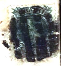
According to the list of imperial post offices (Tabella das Agencias do Correio do Imperio, Rio de Janeiro, 1885), there had been a post office there since 1876. The oldest postmark to date is the French type IPE-0330a (coll. Fuad Ferreira Fo.), which also exists in blue:
IPE-0330a (FF) 1882ff-1890
A mute cancellation (Fuad Ferreira Fo. Coll.) is also known from there:
1882ff (FF)Atlas do Imperio do Brasil, 1868
Andere Namen: També (1938-1975)
Seit Januar 1789 bestand die Freguesia de N. Sra. do Desterro do Itambé, sie gehörte der Vila de Goyanna und lag an der Provinzgrenze zu Paraíba, gegenüber Pedras de Fogo, 90 km nördlich der Hauptstadt Recife. Sie wurde im Mai 1867 zur Vila und im Februar 1879 zu einer Stad erklärt, die zwischen 1938 und 1975 També hieß, bevor der alte Ortsname zurückkehrte.
Laut Verzeichnis der kaiserlichen Postämter (Tabella das Agencias do Correio do Imperio, Rio de Janeiro, 1885) gab es dort ein Postamt seit 1876. Der bisher älteste Poststempel ist der französiche Typ IPE-0330a (Samml. Fuad Ferreira Fo.), den es auch in Blau gibt:
IPE-0330a (FF) 1882ff-1890
Von dort ist auch eine stumme Abstempelung (Samml. Fuad Ferreira Fo.) bekannt:
The Freguesia de N. Sra. da Oliveira de Itambé, founded in April 1841, belonged to the Vila de Conceição do Matto Dentro and was located on the south bank of the Rio Preto, 160 kilometres north of the provincial capital Ouro Preto. It was assigned to the newly founded municipality of Santa Maria de Itabira as Distrito de Itacururu in December 1943 and became the Município de Itambé do Mato Dentro in March 1963.
According to the press in Rio, the local post office was created in July 1859:
Jornal do Commercio/RJ, 16/07/1859
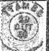
The directory of imperial post offices (Tabella das Agencias do Correio do Imperio, Rio de Janeiro, 1885) gives 1877 as the year of foundation, which indicates a reopening. The oldest cancel to date is IMG-1365b (fig. R. Koester, in Carimbologia XXIII):
IMG-1365b (RK) 1889-1895Provincia de Minas Geraes, 1873
Andere Namen: Itaimbé, Itacururu
Die im April 1841 gegründete Freguesia de N. Sra. da Oliveira de Itambé gehörte zur Vila de Conceição do Matto Dentro und lag am Südufer des Rio Preto, 160 km nördlich der Provinzhauptstadt Ouro Preto. Sie wurde im Dezember 1943 als Distrito de Itacururu der neu gegründeten Gemeinde Santa Maria de Itabira zugeordnet und im März 1963 zum Município de Itambé do Mato Dentro.
Wie der Presse in Rio zu entnehmen ist, gab es seit Juli 1859 ein Postamt am Ort:
Jornal do Commercio/RJ, 16.07.1859
Das Verzeichnis der kaiserlichen Postämter (Tabella das Agencias do Correio do Imperio, Rio de Janeiro, 1885) gibt als Gründungsjahr 1877 an, was auf eine Wiedereröffnung hindeutet. Der bisher älteste Stempel ist IMG-1365b (Abb. R. Koester, in Carimbologia XXIII):
Since 1836 the village was a district of Vila do Principe (today: Serro), near the south bank of the Guanhães, 350 km north of the provincial capital Ouro Preto. In November 1875 it became the Freguesia de Sto. Antonio do Itambé and in December 1962 it was elevated to the Município de Sto. Antonio do Itambé in December 1962. The name Itambé (also Itaimbé) comes from the Tupi-guarani and means pointed stone.
According to the Rio press, there had been a post office there since November 1881:
Jornal do Commercio/RJ, 12/11/1881
The imperial postmark is IMG-3670a (ill. by R. Koester in Carimbologia XXIII):
IMG-3670a (RK) 1888
Koester (op. cit.) also shows the postmark with the imperial seal IMG-3670b:
IMG-3670b (RK)Provincia de Minas Geraes, 1873
Andere Namen: Santo Antonio do Itambé
Seit 1836 war der Ort ein Distrito von Vila do Principe (heute: Serro), nahe dem Südufer des Guanhães, 350 km nördlich der Provinzhauptstadt Ouro Preto. Im November 1875 wurde es zur Freguesia de Sto. Antonio do Itambé und im Dezember 1962 zum Município de Sto. Antonio do Itambé erhoben. Der Name Itambé (auch Itaimbé) stammt aus dem Tupi-guarani und bedeutet spitzer Stein.
Wie aus der Presse von Rio hervorgeht, gab es dort seit November 1881 ein Postamt:
Jornal do Commercio/RJ, 12.11.1881
Der kaiserliche Poststempel ist IMG-3670a (Abb. R. Koester in Carimbologia XXIII):
IMG-3670a (RK) 1888
Koester (op. cit.) zeigt auch den Stempel mit dem kaiserlichen Siegel IMG-3670b:
Villiers de l’Ile Adam: Carta (…) da Provincia de Minas Geraes, 1849
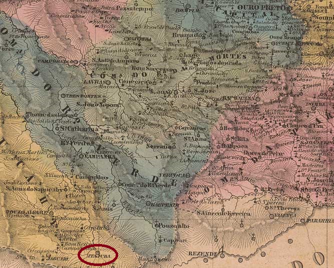
Other names: Boa Vista, Capella Nova
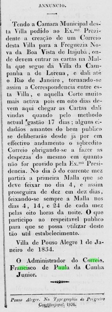
The settlement of Boa Vista do Itajubá was founded in March 1819. It belonged to the Freguesia de Descoberto (today the município de Delfim Moreira) in the Vila de Campanha area and was located on the north bank of the Sapucaí, 420 kilometres southwest of the later provincial capital Ouro Preto. In July 1832 it became the Freguesia de N. Sra. da Conceição da Boa Vista do Itajubá, in September 1848 it was elevated to a Vila and in October 1862 to a town. The name, which comes from the Tupi-guarani, can mean both yellow stone (ita + juba) and waterfall on the river of stones (ita + jybá).
Two creation dates have been found for the local post office. The first was around January 1834, according to the regional press:
O Recopilador Mineiro, 04/01/1834
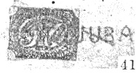
Then again in October 1856, as Nova Monteiro writes in Administrações e Agencias Postaes do Brasil Imperio (Brasil Filatelico/RJ, 1934-5; reprint SPP 1994-1999). The two oldest postmarks, IMG-1355a (fig. R. Koester in Carimbologia XXIII) and IMG-1355b (dto.), date from the agency’s first period of operation:
IMG-1355a (RK) 1835IMG-1355b (RK) 1844ff
Around the time of the reopening, the stamps were initially cancelled by hand, as Koester (op. cit.) shows:
1850ff (RK)
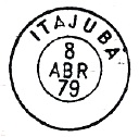
It was not until the 1870s that the circular cancellation IMG-1355c (fig. P. Ayres in Catálogo de Carimbos Brasil-Império, S. Paulo, 1937, 1942) was used:
IMG-1355c (P.A.p. 121) 1879-1884
At this time Itajubá was already a town, as the following cancel IMG-1355d (fig. P. Ayres, op. cit.) proudly points out:
IMG-1355d (P.A. p. 121) 1885-1901
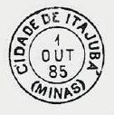
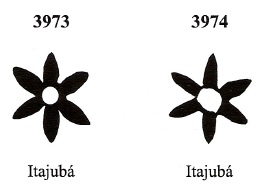
James Dingler and Klerman W. Lopes have listed two mute cancellations from Itajubá in Mute Cancellations of the Brazil Empire / Carimbos Mudos do Brasil Império (Brazil Philatelic Association, Rio de Janeiro, 2000):
BPA 3973 (P.A. 734, 1866ff-1879, also in blue) – 3974Atlas do Imperio do Brasil, 1868
Andere Namen: Boa Vista, Capella Nova
Die Siedlung Boa Vista do Itajubá entstand im März 1819. Sie gehörte zur Freguesia de Descoberto (heute der Município de Delfim Moreira), im Gebiet der Vila de Campanha und lag am Nordufer des Sapucaí, 420 km südwestlich der späteren Provinzhauptstadt Ouro Preto. Im Juli 1832 wurde es zur Freguesia de N. Sra. da Conceição da Boa Vista do Itajubá, im September 1848 zur Vila und im Oktober 1862 zur Stadt erhoben. Der aus dem Tupi-guarani stammende Name kann sowohl gelber Stein (ita + juba) als auch Wasserfall am Fluss der Steine (ita + jybá) bedeuten.
Für das örtliche Postamt wurden zwei Gründungsdaten gefunden. Die erste um Januar 1834, wie aus der regionalen Presse hervorgeht:
O Recopilador Mineiro, 04.01.1834
Dann wieder im Oktober 1856, wie Nova Monteiro in Administrações e Agencias Postaes do Brasil Imperio (Brasil Filatelico/RJ, 1934-5; Nachdruck SPP 1994-1999) schreibt. Die beiden ältesten Stempel, IMG-1355a (Abb. R. Koester in Carimbologia XXIII) und IMG-1355b (dto.), stammen wohl aus der ersten Betriebsperiode der Agentur:
IMG-1355a (RK) 1835IMG-1355b (RK) 1844ff
Um die Zeit der Wiedereröffnung wurden die Marken zunächst von Hand entwertet, wie Koester (op. cit.) zeigt:
1850ff (RK)
Erst in den 1870er Jahren wurde der Rundstempel IMG-1355c (Abb. P. Ayres in Catálogo de Carimbos Brasil-Império, S. Paulo, 1937, 1942) verwendet:
IMG-1355c (P.A. S. 121) 1879-1884
Zu diesem Zeitpunkt war Itajubá bereits eine Stadt, worauf der folgende Stempel IMG-1355d (Abb. P. Ayres, op. cit.) stolz hinweist:
IMG-1355d (P.A. S. 121) 1885-1901
James Dingler und Klerman W. Lopes haben in Mute Cancellations of the Brazil Empire / Carimbos Mudos do Brasil Império (Brazil Philatelic Association, Rio de Janeiro, 2000) zwei stumme Abstempelungen aus Itajubá aufgelistet:
BPA 3973 (P.A. 734, 1866ff-1879, auch in Blau) – 3974
Villiers de l’Ile Adam: Carta (…) da provincia de Santa Catharina, 1848
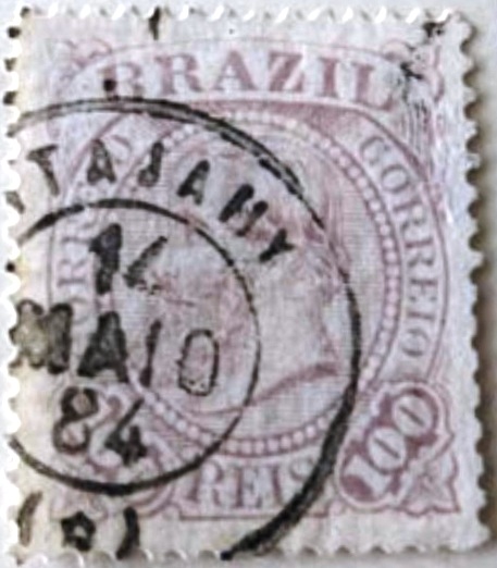
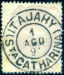
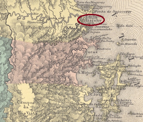
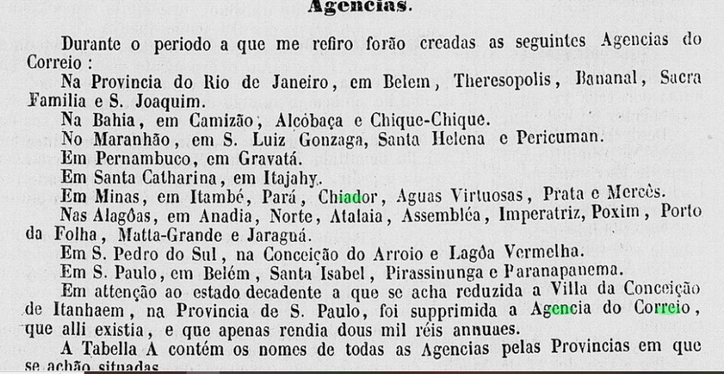
In 1820, the fisher’s colony of Itajahy was founded on the south bank of the Itajahy estuary in the Atlantic Ocean, 100 kilometres north of the future provincial capital of Desterro (now Florianópolis). Ten years later, the colony became Curato of the Vila de S. Francisco and in August 1833 Freguesia do Santissimo Sacramento de Itajahy. In April 1859 it became a Vila and in July 1877 a town, now spelled Itajaí.
Two dates have been found for the foundation of the local post office. The first is in February 1841, as R. Koester writes in Carimbologia XXIII and is confirmed by the report of the Imperial Ministry (Relatorio do Ministerio do Imperio):
Relatorio do Ministerio do Imperio , May 1841
The agency was closed by 1856, as it is no longer mentioned in the postal guide (Guia do Correio do Brasil, Rio de Janeiro 1857), and reopened in 1859, as can be seen from the report of the Postal Directorate (Directoria Geral dos Correios) of March 1860:
Relatório DGC, in Relatorio do Ministerio do Imperio, March 1860
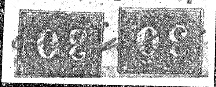
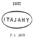
The oldest postmark to date is ISC-0130a, which was probably used in the first period of operation of the post office and is recorded in Cicero A. Almeida’s Carimbos Postais – século XIX (Rio de Janeiro, 1989) with the number 744:
ISC-0130a (MPT 744)
Then came ISC-0130b, which is listed in the P. Ayres’ Catálogo de Carimbos Brasil-Império (S. Paulo, 1937, 1942) under no. 1327:
ISC-0130b (P.A. 1327) 1877ff-1879
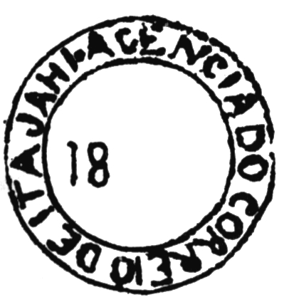
This was followed by the circle cancellation ISC-0130c (illustration from the Internet):
ISC-0130c (EB) 1876ff-1887
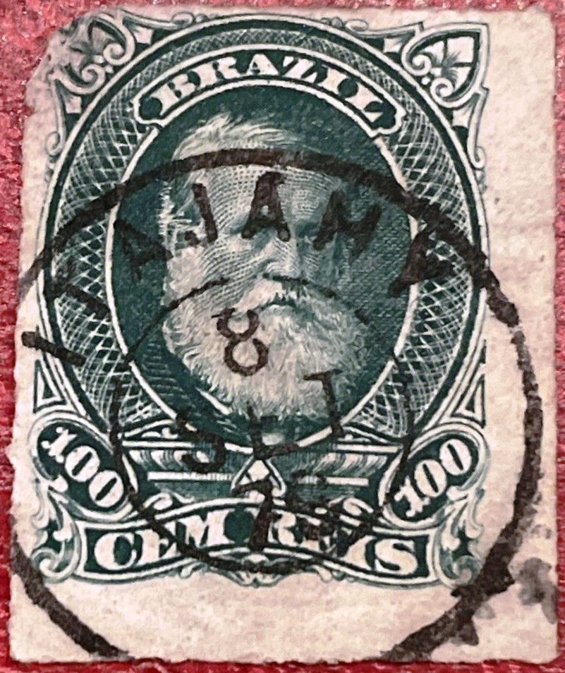
Towards the end of the Empire, two further postmarks also appeared, initially the French type ISC-0130d (illustration from the Internet):
ISC-0130d (EB) 1884-1887
Then also ISC-0130e (illustration from the Internet):
ISC-0130e (EB) 1889-1897
R. Koester showed in Carimbologia also the cancel with the imperial seal ISC-0130f:
ISC-0130f (RK)Atlas do Imperio do Brasil, 1868
1820 wurde am Südufer der Mündung des Itajahy in den Atlantik, 100 km nördlich der späteren Provinzhauptstadt Desterro (heute Florianópolis), die Fischerkolonie Itajahy gegründet. Zehn Jahre später wurde die Kolonie Curato der Vila de S. Francisco und im August 1833 Freguesia do Santissimo Sacramento de Itajahy. Im April 1859 wurde sie zur Vila und im Juli 1877 zur Stadt erhoben.
Für die Gründung des örtlichen Postamtes wurden zwei Daten gefunden. Zum ersten Mal im Februar 1841, wie R. Koester in Carimbologia XXIII schreibt und durch den Bericht des kaiserlichen Ministeriums (Relatorio do Ministerio do Imperio) bestätigt wird:
Relatorio do Ministerio do Imperio , Mai 1841
Die Agentur wurde bis 1856 geschlossen, da sie im Postführer (Guia do Correio do Brasil, Rio de Janeiro 1857) nicht mehr erwähnt wird, und 1859 wieder eröffnet, wie aus dem Bericht der Postdirektion (Directoria Geral dos Correios) vom März 1860 hervorgeht:
Relatório DGC, in Relatorio do Ministerio do Imperio, März 1860
Der bisher älteste Poststempel ist ISC-0130a, der vermutlich in der ersten Betriebsperiode des Postamts verwendet wurde und im Cicero A. Almeidas Carimbos Postais – século XIX (Rio de Janeiro, 1989) die Nummer 744 erhielt:
ISC-0130a (MPT 744)
Danach kam ISC-0130b, der im P. Ayres’ Catálogo de Carimbos Brasil-Império (S. Paulo, 1937, 1942) unter Nr. 1327 aufgeführt wird:
ISC-0130b (P.A. 1327) 1877ff-1879
Es folgte der Kreisstempel ISC-0130c (Abb. aus dem Internet):
ISC-0130c (EB) 1876ff-1887
Gegen Ende des Kaiserreichs erschienen auch zwei weitere Poststempel, zunächst der französischer Typ ISC-0130d (Abb. aus dem Internet):
ISC-0130d (EB) 1884-1887
Dann auch ISC-0130e (Abb. aus dem Internet):
ISC-0130e (EB) 1889-1897
R. Koester zeigte in Carimbologia noch den Stempel mit dem kaiserlichen Siegel ISC-0130f:
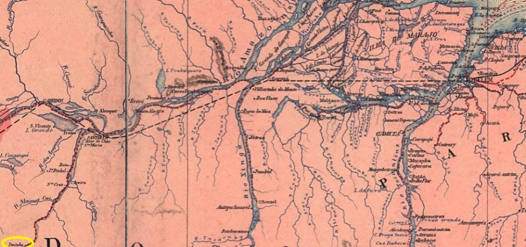
Around 1810, a harbour was built on the left bank of the Tapajós near the settlement of Pinhel, 900 km southwest of the later provincial capital of Belém do Pará. In 1853, the settlement created there was incorporated into the Freguesia de Boim, which belonged to the Vila de Santarém. In December 1856, it was elevated to Vila de Sant’Anna de Itaituba, which was declared a town in March 1900. In December 1930, it was downgraded to a district and assigned directly to the state of Pará. The Município de Itaituba has existed again since October 1935. The word comes from the Tupi language and means rivers rich in stones.
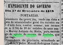
R. Koester writes in Carimbologia XXIII that there had been a post office there since 1882. However, this was a reopening, as there was a postal agency in Itaituba already mentioned in the regional press in December 1878:
O Liberal do Pará, 24/12/1878
As the post office is not mentioned in the imperial postal guide (Guia Postal do Imperio, 1880), it must have been closed by 1879 at the latest.
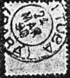
The oldest postmark to date is IPA-0140a (fig. Koester, op. cit.):
IPA-0140a (RK) 1890Carta da Republica dos Estados Unidos do Brazil, 1892
Um 1810 entstand am linken Ufer des Tapajós im Bereich der Siedlung Pinhel, 900 km südwestlich der späteren Provinzhauptstadt Belém do Pará, ein Hafen. 1853 wurde die dort entstandene Siedlung der Freguesia de Boim zugeschlagen, die zur Vila de Santarém gehörte. Im Dezember 1856 erfolgte die Erhebung zur Vila de Sant’Anna de Itaituba, die im März 1900 zur Stadt erklärt wurde. Im Dezember 1930 erfolgte die Herabstufung zum Distrikt, der direkt dem Bundesstaat Pará zugeordnet wurde. Seit Oktober 1935 gibt es wieder das Município de Itaituba. Das Wort stammt aus der Tupi-Sprache und bedeutet steinreiche Flüsse.
R. Koester schreibt in Carimbologia XXIII, dass es dort seit 1882 ein Postamt gab. Es handelt sich jedoch um eine Wiedereröffnung, da bereits im Dezember 1878 in der regionalen Presse von einer Postagentur in Itaituba die Rede war:
O Liberal do Pará, 24.12.1878
Da das Postamt im kaiserlichen Postführer (Guia Postal do Imperio, 1880) nicht erwähnt wird, muss es spätestens 1879 geschlossen worden sein.
Der bisher älteste Poststempel ist IPA-0140a (Abb. Koester, op. cit.):