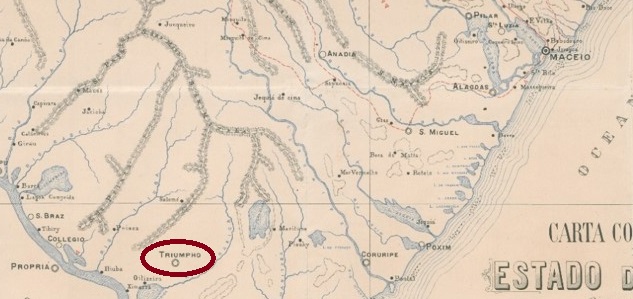
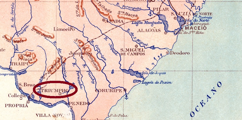
The Freguesia de Igreja Nova, which had existed since June 1880, belonged to the Vila de Agua Branca and was located on the north bank of the Riacho Boacica, 160 kilometres southwest of the provincial capital of Maceió. In June 1890 it was elevated to Vila de Triumpho, which became a town in May 1892. In July 1895, it was downgraded to a district of the Município de Penedo, before being elevated to a Município again in May 1897. The old name Igreja Nova returned in June 1928.
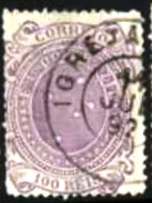
As Aldo Cardoso writes in Contribuição para a História dos Correios de Alagoas (Maceió, 1969), there had been a post office there since July 1868. The oldest postmark to date is IAL-0070b (image from the Internet):
IAL-0070b (Philasearch) 1887-1892Briguiet: Estado de Alagoas, 1923
Andere Namen: Oitiseiro, Triumpho (1890-1928)
Die seit Juni 1880 bestehende Freguesia de Igreja Nova gehörte zur Vila de Agua Branca und lag am Nordufer des Riacho Boacica, 160 km südwestlich der Provinzhauptstadt Maceió. Im Juni 1890 wurde es zur Vila de Triumpho erhoben, die im Mai 1892 zur Stadt wurde. Im Juli 1895 wurde es zum Distrikt des Município de Penedo herabgestuft, bevor es im Mai 1897 wieder zum Município erhoben wurde. Im Juni 1928 kehrte der alte Name Igreja Nova zurück.
Wie Aldo Cardoso in Contribuição para a História dos Correios de Alagoas (Maceió, 1969) schreibt, gab es dort seit Juli 1868 ein Postamt. Der bisher älteste Poststempel ist IAL-0070b (Abbildung aus dem Internet):
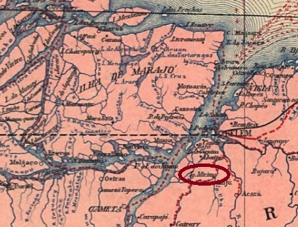
Villiers de l’Ile Adam: Carta (…) das Provincias do Gräo Pará e Alto Amazonas, 1850
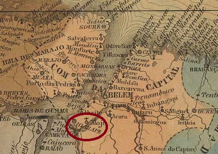
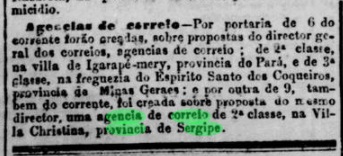
Other names: Igarapé-Miri
The Freguesia de Sant’Anna do Igarapé-Mery, in existence since 1758, belonged to the Vila de Belém do Pará and was located on the north bank of the Igarapé-Miri, 90 kilometres southwest of the later provincial capital Belém do Pará. In October 1843 it became a Vila and in May 1896 the town of Igarapé-Miri (current spelling).
The list of imperial post offices (Tabella das Agencias do Correio do Imperio, Rio de Janeiro, 1885) shows that there had been a post office there since 1882. This was confirmed by the press in Rio:
Jornal do Commercio/RJ, 11/10/1882
No imperial postmarks have yet been found from Igarapé-Mery.
Carta da Republica dos Estados Unidos do Brazil, 1892
Andere Namen: Igarapé-Miri
Die seit 1758 bestehende Freguesia de Sant’Anna do Igarapé-Mery gehörte zur Vila de Belém do Pará und lag am Nordufer des Igarapé-Miri, 90 km südwestlich der späteren Provinzhauptstadt Belém do Pará. Im Oktober 1843 wurde es zur Vila und im Mai 1896 zur Stadt Igarapé-Miri (heutige Schreibweise) erhoben.
Aus dem Verzeichnis der kaiserlichen Postämter (Tabella das Agencias do Correio do Imperio, Rio de Janeiro, 1885) geht hervor, dass es dort seit 1882 ein Postamt gab. Dieses wurde von der Presse in Rio bestätigt:
Jornal do Commercio/RJ, 11.10.1882
Aus Igarapé-Mery sind bisher keine kaiserlichen Poststempel gefunden worden.
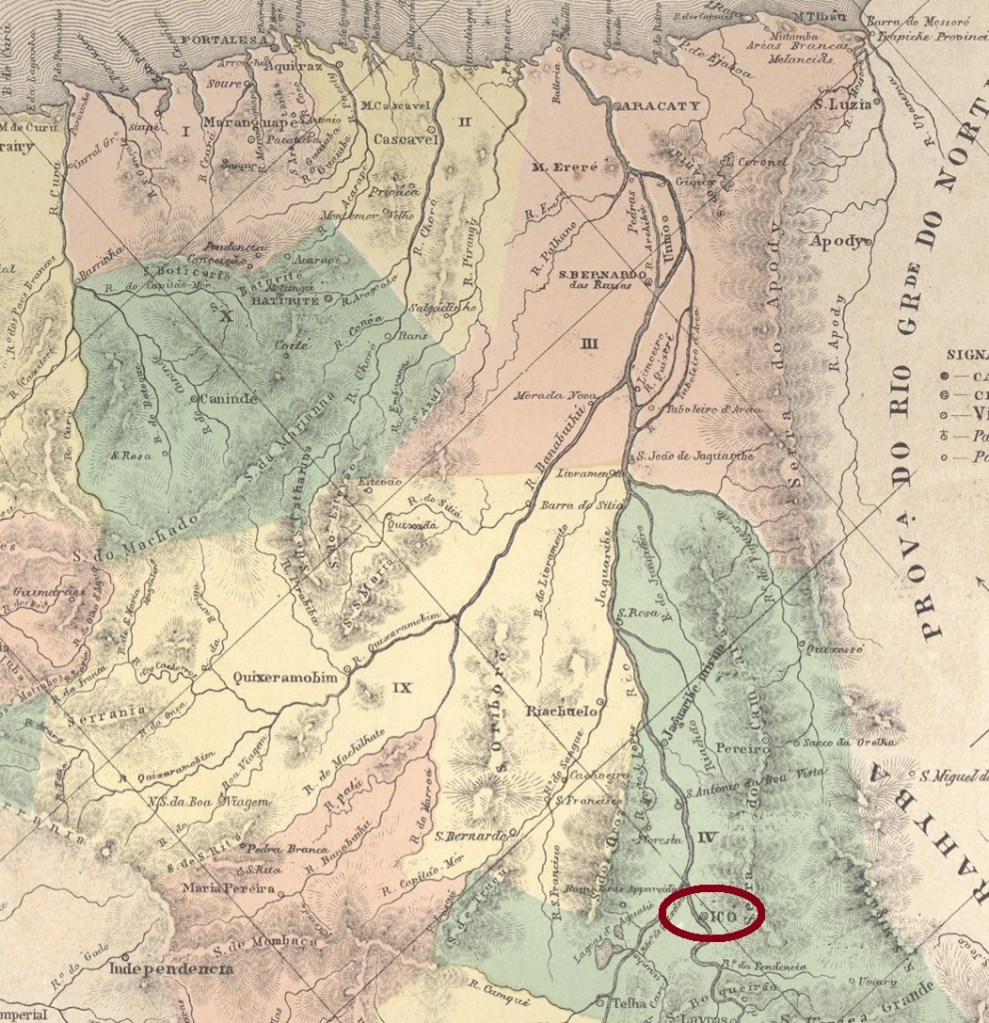
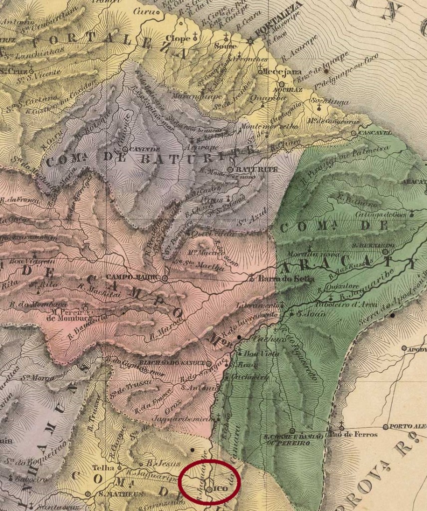
Other names: Ribeira dos Icós, Arraial Velho, Arraial Novo, Icó dos Fonsecas, Icó dos Montes
The Vila do Arraial da Ribeira dos Icós had existed on the east bank of the Rio Salgado, 360 kilometres south of the later provincial capital of Fortaleza, since October 1736. In April 1764, this became the Freguesia de N. Sra. da Expectação de Icó. Icó has been a town since October 1842. The name comes from the indigenous language Tupi-Guarani and means field river.
Two dates have been found for the foundation of the local post office. R. Koester in Carimbologia XXII gives December 1845, while Nova Monteiro in Administrações e Agencias Postaes do Brasil Imperio (Brasil Filatelico/RJ, 1934-5; reprint SPP 1994-1999) gives January 1847.
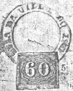
The oldest postmark to date is ICE-0155a (fig. R. Koester, op. cit.), which also exists in red:
ICE-0155a (RK) 1850ff
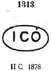
It is followed by ICE-0155b, which also exists in yellow and was given the no. 1313 by P. Ayres in Catálogo de Carimbos Brasil-Império, (S. Paulo, 1937, 1942):
ICE-0155b (P.A. 1313) 1866ff-1879
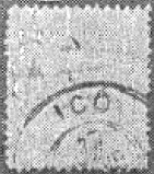
This was followed by the double circle ICE-0155c (fig. R. Koester), which also exists in dark violet:
ICE-0155c (RK)
Koester also showed the cachet ICE-0155d:
ICE-0155d (RK) Villiers de l’Ie Adam: Carta (…) da Provincia do Ceará, 1849
Andere Namen: Ribeira dos Icós, Arraial Velho, Arraial Novo, Icó dos Fonsecas, Icó dos Montes
Seit Oktober 1736 bestand am Ostufer des Rio Salgado, 360 km südlich der späteren Provinzhauptstadt Fortaleza, die Vila do Arraial da Ribeira dos Icós. Im April 1764 wurde daraus die Freguesia de N. Sra. da Expectação de Icó. Seit Oktober 1842 ist Icó eine Stadt. Der Name aus der indigenen Sprache Tupi-Guarani bedeutet Feldfluss.
Für die Gründung des örtlichen Postamtes wurden zwei Daten gefunden. R. Koester nennt in Carimbologia XXII den Dezember 1845, während Nova Monteiro in Administrações e Agencias Postaes do Brasil Imperio (Brasil Filatelico/RJ, 1934-5; Nachdruck SPP 1994-1999) den Januar 1847 angibt.
Der bisher älteste Stempel ist ICE-0155a (Abb. R. Koester, op. cit.), der auch in rot existiert:
ICE-0155a (RK) 1850ff
Es folgt ICE-0155b, der auch in gelb existiert und von P. Ayres in Catálogo de Carimbos Brasil-Império, (S. Paulo, 1937, 1942) die Nr. 1313 erhielt:
ICE-0155b (P.A. 1313) 1866ff-1879
Danach kam der Doppelkreis ICE-0155c (Abb. R. Koester), der auch in dunkelviolett existiert:
Villier de l’Ile Adam: Carta (…) da Provincia do Maranhão, 1850
Text update of April 5, 2026
Other names: Aguas Boas, Sta. Maria de Guaxenduba
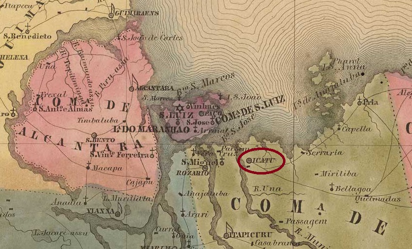
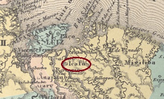
The former Vila de N. Sra. da Ajuda de Aguas Boas was founded in January 1688 and later moved to the site of the Arraial de Sta. Maria de Guaxenduba on the east bank of the Munim, 100 kilometres south-east of the provincial capital of São Luís do Maranhão. The Vila was given the name N. Sra. da Conceição do Icatu in April 1835. Icatu has been a town since April 1924.
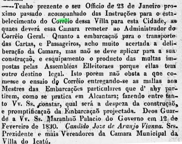
Two dates have been found for the foundation of the local post office. Nova Monteiro (Administrações e Agencias Postaes do Brasil Imperio, in Brasil Filatelico/RJ, 1934-5; Reprint SPP) gives March 1830, which is confirmed by the regional press:
Pharol Maranhense/02/03/1830
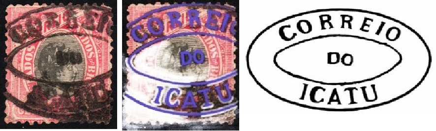
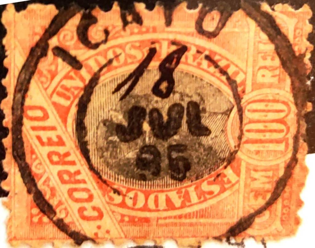
R. Koester (Carimbologia XXII) gives December 1832, as can also be read in the 1886 postal report (Relatorio dos Correios). The oldest postmark to date is IMA-0135b (coll. Márcio Protzner, restored image by W. Sonnenberg):
IMA-0135b (MP/WS) 1866ff-1894ff
It was followed by IMA-0135c (fig. Jorge L. Pedreira):
IMA-0135c (JLP) 1891-1895 Atlas do Imperio do Brasil, 1868
Texto atualizado em 5 de abril de 2026
Outros nomes: Águas Boas, Sta. Maria de Guaxenduba
A antiga Vila de N. Sra. da Ajuda de Águas Boas foi fundada em janeiro de 1688 e depois transferida para o local do Arraial de Sta. Maria de Guaxenduba, na margem leste do Munim, 100 quilômetros a sudeste da capital da província de São Luís do Maranhão. A Vila recebeu o nome de N. Sra. da Conceição do Icatu em abril de 1835. Icatu é uma cidade desde abril de 1924.
Foram encontradas duas datas para a fundação da agência postal local. Nova Monteiro (Administrações e Agencias Postaes do Brasil Imperio, in Brasil Filatelico/RJ, 1934-5; Reprint SPP) dá março de 1830, o que é confirmado pela imprensa regional:
Pharol Maranhense/02/03/1830
R. Koester (Carimbologia XXII) dá dezembro de 1832, como também pode ser lido no relatório postal de 1886 (Relatorio dos Correios). O carimbo postal mais antigo até o momento é o IMA-0135b (col. Márcio Protzner, imagem restaurada por W. Sonnenberg):
IMA-0135b (MP/WS) 1866ff-1894ff
Ele foi seguido pelo IMA-0135c (fig. Jorge L. Pedreira):
IMA-0135c (JLP) 1891-1895, também em azulCarta da Republica dos Estados Unidos do Brazil, 1892
Textaktualisierung am 05. April 2026
Andere Namen: Aguas Boas, Sta. Maria de Guaxenduba
Die ehemalige Vila de N. Sra. da Ajuda de Aguas Boas wurde im Januar 1688 gegründet und später an die Stelle des Arraial de Sta. Maria de Guaxenduba am Ostufer des Munim, 100 km südöstlich der Provinzhauptstadt São Luís do Maranhão, verlegt. Die Vila erhielt im April 1835 den Namen N. Sra. da Conceição do Icatu. Seit April 1924 ist Icatu eine Stadt.
Für die Gründung des örtlichen Postamtes wurden zwei Daten gefunden. Nova Monteiro (Administrações e Agencias Postaes do Brasil Imperio, in Brasil Filatelico/RJ, 1934-5; Reprint SPP) gibt den März 1830 an, was von der regionalen Presse bestätigt wird:
Pharol Maranhense/02.03.1830
R. Koester (Carimbologia XXII) nennt Dezember 1832, wie auch im Postbericht 1886 (Relatorio dos Correios) zu lesen ist. Der bisher älteste Poststempel ist IMA-0135b (Sammlg. Márcio Protzner, Bildrestaurierung durch W. Sonnenberg):
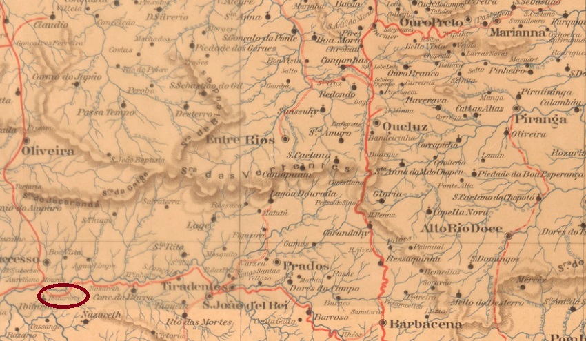
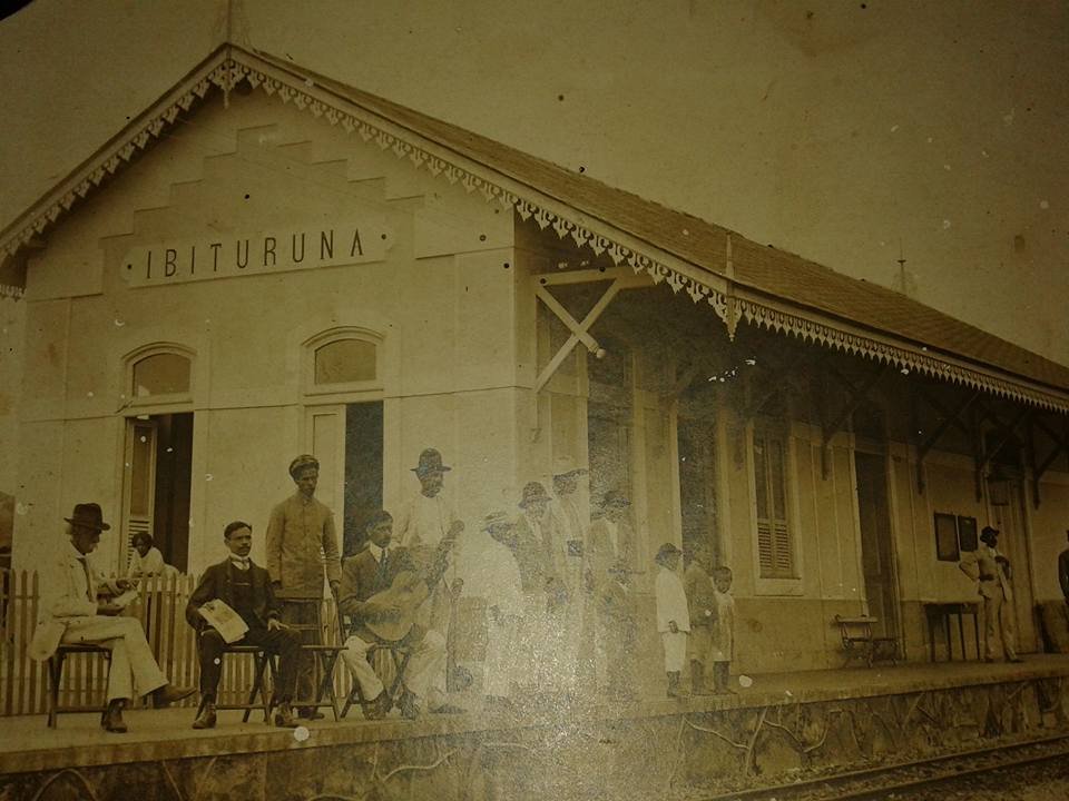
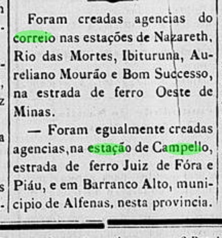
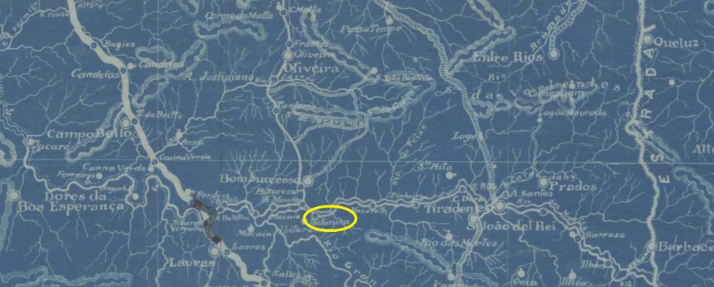
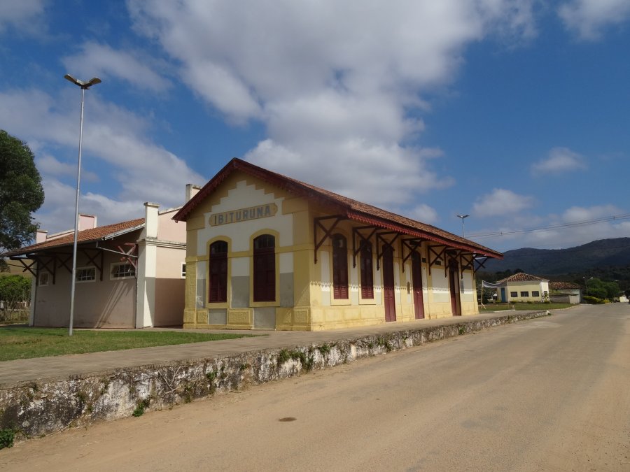
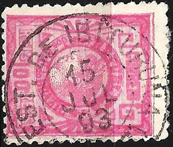
From November 1865, São Gonçalo de Ibituruna was a freguesia of the Vila de S. João d’El-Rei on the Rio das Mortes, about 230 km south-west of the provincial capital Ouro Preto. A railway station belonging to the E.F. Oeste de Minas company (Paraopeba Line) was opened there in October 1887. The line was transferred to Rede Mineira de Viação in 1931, to V.F. Centro-Oeste in 1965 and belonged to Rede Ferroviária Federal S.A. (estacoesferroviarias.com.br) from 1975 until it was closed in 1984. Today the tracks have disappeared, and the station building is a cultural centre of the municipality of Ibituruna, an independent município since 1962.
1914 (photo NN, on estacoesferroviarias.com.br)2016 (photo Fernando Marietan, on estacoesferroviarias.com.br)
Paula Sobrinho (História Postal de Minas Gerais, Belo Horizonte, 1997) and R. Koester (Carimbologia XXII) agree that there has been a post office at the railway station since December 1887. This is confirmed by the regional press:
O Pharol, 19/12/1887
The oldest postmark to date is IMG-1325a (illustration by Luiz C. Fritzen):
IMG-1325a (LCF) 1893E. F. Oeste de Minas, 1917
Siehe auch S. Gonçalo de Ibituruna (SMG-2310)
São Gonçalo de Ibituruna war seit November 1865 eine Freguesia der Vila de S. João d’El-Rei am Rio das Mortes, etwa 230 km südwestlich der Provinzhauptstadt Ouro Preto. Dort wurde im Oktober 1887 ein Bahnhof der Gesellschaft E.F. Oeste de Minas (Paraopeba-Linie) eröffnet. Die Strecke ging 1931 an die Rede Mineira de Viação, 1965 an die V.F. Centro-Oeste und gehörte von 1975 bis zu ihrer Stilllegung 1984 der Rede Ferroviária Federal S.A. (estacoesferroviarias.com.br). Heute sind die Gleise verschwunden, das Bahnhofsgebäude ist ein Kulturzentrum der Gemeinde Ibituruna, seit 1962 ein eigenständiges Município.
1914 (Foto NN, auf estacoesferroviarias.com.br)2016 (Foto Fernando Marietan, auf estacoesferroviarias.com.br)
Paula Sobrinho (História Postal de Minas Gerais, Belo Horizonte, 1997) und R. Koester (Carimbologia XXII) sind sich einig, dass es seit Dezember 1887 ein Postamt am Bahnhof gab. Dies wird von der regionalen Presse bestätigt:
O Pharol, 19.12.1887
Der bisher älteste Poststempel ist IMG-1325a (Abb. Luiz C. Fritzen):
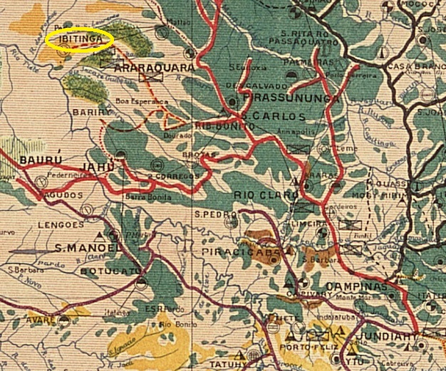
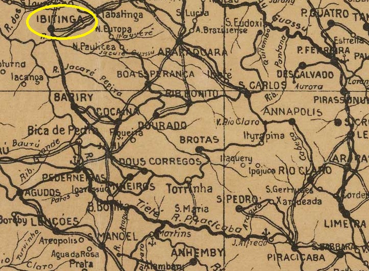
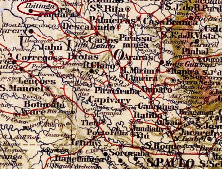
The Freguesia de Senhor Bom Jesus de Ibitinga was founded in April 1885 and belonged to the Vila de Araraquara, near the north bank of the Jacaré-Guaçu, 350 kilometres northwest of the provincial capital of São Paulo. In July 1890 it was elevated to a Vila in its own Município.
R. Koester writes in Carimbologia XXII that there had been a post office there since February 1887. This is confirmed by the press in Rio:
Jornal do Commercio/RJ, 13/02/1887
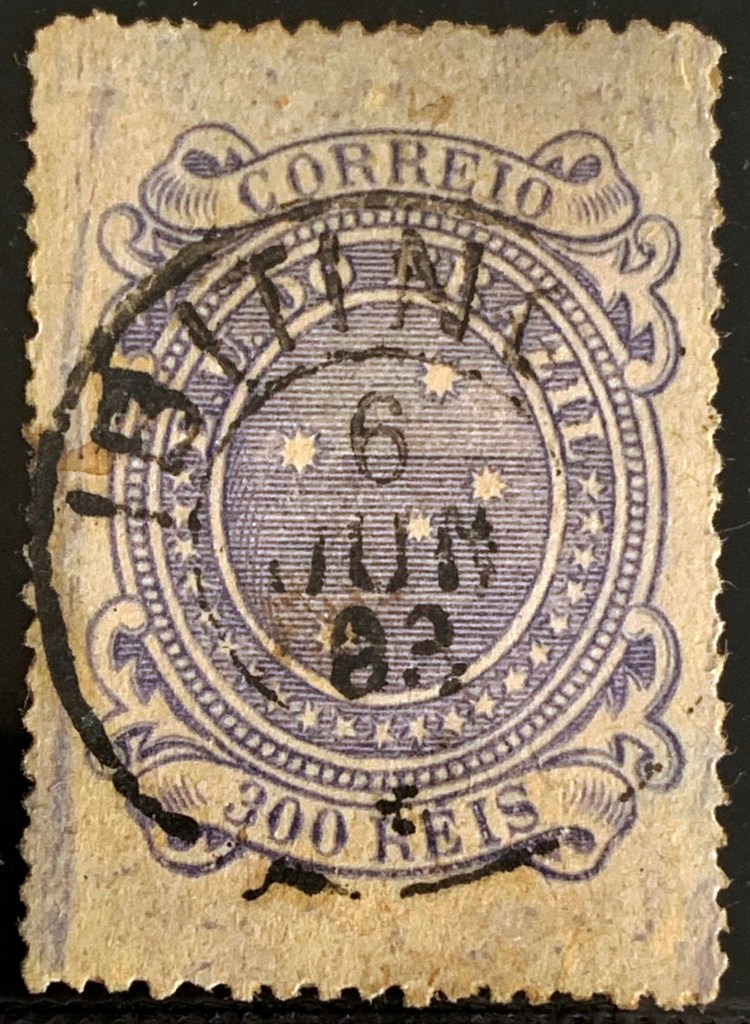
The oldest postmark from the 19th century found to date is ISP-0580a (image by Alexandre Andrade):
ISP-0580a (AA) 1893
It was followed by ISP-0580b (image from the Internet):
ISP-0580b (EB) 1896-1898Arthur D. Ribeiro: Estado de São Paulo, 1924
Texto atualizado em 1º de março de 2026
A Freguesia do Senhor Bom Jesus de Ibitinga foi fundada em abril de 1885 e pertencia à Vila de Araraquara, perto da margem norte do Jacaré-Guaçu, 350 quilômetros a noroeste da capital da província de São Paulo. Em julho de 1890, foi elevada à condição de Vila em seu próprio Município. A palavra ibitinga é de origem tupi-guarani e significa terra branca.
R. Koester escreve em Carimbologia XXII que havia uma agência postal no local desde fevereiro de 1887. Isso é confirmado pela imprensa do Rio:
Jornal do Commercio/RJ, 13/02/1887
O carimbo postal mais antigo do século XIX até o momento encontrado é o ISP-0580a (imagem de Alexandre Andrade):
ISP-0580a (AA) 1893
Ele foi seguido pelo ISP-0580b (imagem da Internet):
ISP-0580b (EB) 1896-1898Mappa Geral do Brasil, 1911
Textaktualisierung am 1. März 2026
Die Freguesia de Senhor Bom Jesus de Ibitinga wurde im April 1885 gegründet und gehörte zur Vila de Araraquara, nahe dem Nordufer des Jacaré-Guaçu, 350 km nordwestlich der Provinzhauptstadt São Paulo. Im Juli 1890 erfolgte die Erhebung zur Vila im eigenen Município.
R. Koester schreibt in Carimbologia XXII, dass es dort seit Februar 1887 ein Postamt gab. Dies wird von der Presse in Rio bestätigt:
Jornal do Commercio/RJ, 13.02.1887
Der älteste bisher gefundene Poststempel aus dem 19. Jahrhundert ist ISP-0580a (Bild: Alexandre Andrade):
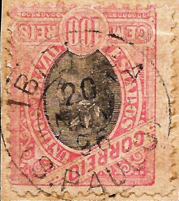
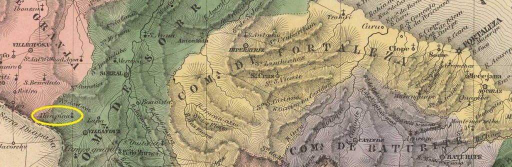
In March 1842, the old settlement became a distrito of the Vila de São Benedito, located near the Serra de Ibiapaba, 310 kilometres west of the provincial capital Fortaleza. It was elevated to a Vila in November 1878, but it was not until August 1882 that it became the Freguesia de S. Pedro da Ibiapina. In May 1931, Ibiapina was downgraded to a Distrito in the Município S. Benedito, but in December 1933 its former status as a Vila was restored. Ibiapina has been a town since December 1938. The term comes from the Tupi language and means land without plants.
As R. Koester writes in Carimbologia XXII, there has been a post office there since March 1879. Two postmarks from the imperial era were found. ICE-0150a (FM collection) is only known in red:
ICE-0150a (FM) 1885
R. Koester (op. cit.) also shows the postmark with the imperial seal ICE-0150b:
ICE-0150b (RK)Villiers de l’Ile Adam: Carta (…) da Provincia do Ceara, 1849
Andere Namen. Ibiapaba
Im März 1842 wurde die alte Siedlung ein Distrito der Vila de São Benedito, gelegen in der Serra de Ibiapaba, 310 km westlich der Provinzhauptstadt Fortaleza. Die Erhebung zur Vila erfolgte im November 1878, doch erst im August 1882 wurde der Ort zur Freguesia de S. Pedro da Ibiapina. Im Mai 1931 wurde Ibiapina zum Distrito im Município S. Benedito herabgestuft, aber im Dezember 1933 wurde der alte Status als Vila wiederhergestellt. Seit Dezember 1938 ist Ibiapina eine Stadt. Der Begriff stammt aus der Tupi-Sprache und bedeutet pflanzenloses Land.
Wie R. Koester in Carimbologia XXII schreibt, gab es dort seit März 1879 ein Postamt. Aus der Kaiserzeit wurden zwei Poststempel gefunden. ICE-0150a (Sammlung FM) ist bisher nur in rot bekannt:
ICE-0150a (FM) 1885
R. Koester (op. cit.) zeigt auch den Stempel mit dem kaiserlichen Siegel ICE-0150b:
Villiers de l’Ile Adam: Carta (…) da Provincia de Minas Geraes, 1849
Other names: Berthioga
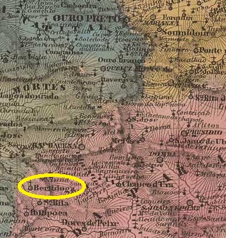
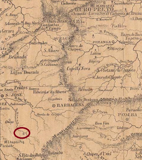
Since 1836, the village was a distrito of the Vila de Barbacena on the south bank of the Elvas River, 170 kilometres south of the provincial capital Ouro Preto. In November 1880 it became the Freguesia de Sto. Antonio da Ibertioga, and in December 1938 the place name was changed to Distrito de Ibertioga. Ibertioga has been an independent município since December 1962. The name comes from the indigenous language Tupi-guarani and means home of the small mosquitoes.
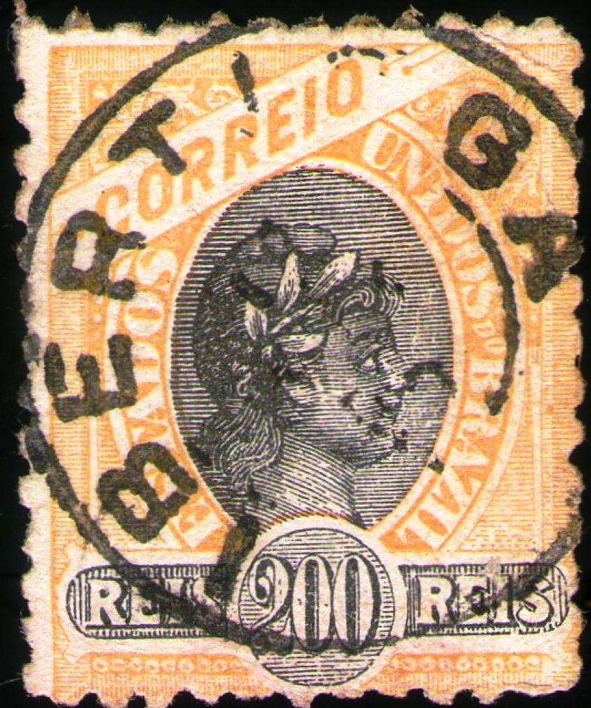
As both Paula Sobrinho (História Postal de Minas Gerais, Belo Horizonte, 1997) and R. Koester (Carimbologia XXII) write, there had been a post office there since April 1881. The oldest postmark to date is the double circle IMG-1315a (ill. Claudio Coelho):
IMG-1315a (CC) 1887-1894ffProvincia de Minas Geraes, 1873
Andere Namen: Berthioga
Der Ort war seit 1836 ein Distrito der Vila de Barbacena am Südufer des Flusses Elvas, 170 km südlich der Provinzhauptstadt Ouro Preto. Im November 1880 wurde es zur Freguesia de Sto. Antonio da Ibertioga, im Dezember 1938 wurde der Ortsname in Distrito de Ibertioga geändert. Seit Dezember 1962 ist Ibertioga ein eigenständiges Município. Der Name stammt aus der indigenen Sprache Tupi-guarani und bedeutet Heimat der kleinen Mücken.
Wie sowohl Paula Sobrinho (História Postal de Minas Gerais, Belo Horizonte, 1997) als auch R. Koester (Carimbologia XXII) schreiben, gab es dort seit April 1881 ein Postamt. Der bisher älteste Poststempel ist der Doppelkreis IMG-1315a (Abb. Claudio Coelho):
Villiers de l’Ile Adam: Carta (…) da Provincia do Piauhy, 1850
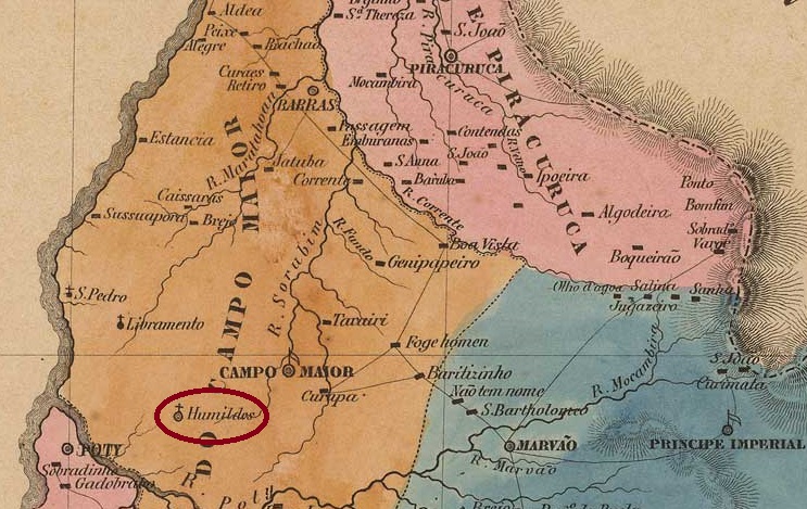
Other names: Alto Longá (1890)
Since August 1870, N. Sra. dos Humildes was the curato of the Freguesia de N. Sra. das Dores, which in turn belonged to the Vila de Teresina. Located on the south bank of the River Gameleira, 80 kilometres east of the provincial capital Teresina, the village became a freguesia in June 1874 and a year later a vila, which was given the name Alto Longá in January 1890. After a period (June 1931 to August 1934) as a district of the Município de Alto, the status of a Município was restored.
As can be seen from the list of imperial post offices (Tabella das Agencias do Correio do Imperio, Rio de Janeiro, 1885), there had been a post office there since 1882. Unfortunately, no imperial postmarks from Humildes have been found to date.
Atlas do Imperio do Brasil, 1868
Andere Namen: Alto Longá (1890)
Seit August 1870 war N. Sra. dos Humildes Curato der Freguesia de N. Sra. das Dores, die ihrerseits zur Vila de Teresina gehörte. Der am Südufer des Flusses Gameleira, 80 km östlich der Provinzhauptstadt Teresina gelegene Ort wurde im Juni 1874 zur Freguesia und ein Jahr später zur Vila, die im Januar 1890 den Namen Alto Longá erhielt. Nach einer Periode (Juni 1931 bis August 1934) als Distrikt des Município de Alto wurde der Status eines Município wiederhergestellt.
Wie aus dem Verzeichnis der kaiserlichen Postämter (Tabella das Agencias do Correio do Imperio, Rio de Janeiro, 1885) hervorgeht, gab es dort seit 1882 ein Postamt. Bisher wurden leider keine kaiserlichen Poststempel aus Humildes gefunden.
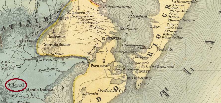
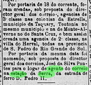
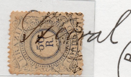
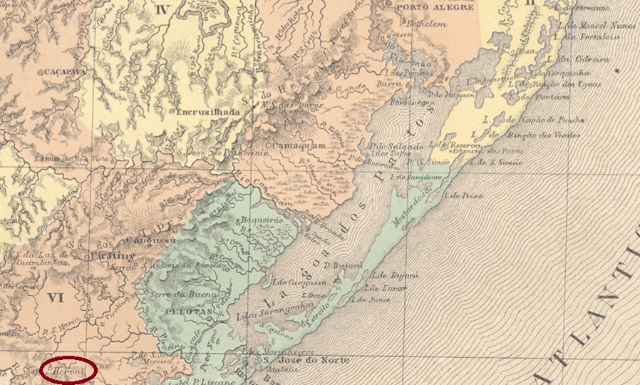
São João Baptista do Herval (also spelt Erval) was a freguesia of the Vila de Jaguarão on the east bank of the Arroio Grande, 400 km south-west of the provincial capital Porto Alegre, from January 1825. The village was elevated to a Vila in May 1881 and to a Município in June 1972. The name comes from the mate bushes, which were found in large quantities in the area.
The local post office was created in October 1882, as reported in the Rio press:
Gazeta da Tarde/RJ, 19/10/1882
The imperial postmark is VRS-0190a (collect. Fuad Ferreira Fo.)
VRS-0190a (FF) 1886-1898ff
Philatelist Carlos Aldir C. Balata also shows a handwritten cancellation from there:
1887ff (CB)Atlas do Imperio do Brasil, 1868
São João Baptista do Herval (auch Erval geschrieben) war seit Januar 1825 eine Freguesia der Vila de Jaguarão am Ostufer des Arroio Grande, 400 km südwestlich der Provinzhauptstadt Porto Alegre. Der Ort wurde im Mai 1881 zur Vila und im Juni 1972 zum Município erhoben. Der Name stammt von den Mate-Sträuchern, die in der Gegend in großen Mengen vorkamen.
Die Einrichtung eines örtlichen Postamts wurde im Oktober 1882 beschlossen, wie die Presse von Rio berichtet:
Gazeta da Tarde/RJ, 19.10.1882
Der kaiserliche Poststempel lautet VRS-0190a (Samml. Fuad Ferreira Fo.)
VRS-0190a (FF) 1886-1898ff
Der Philatelist Carlos Aldir C. Balata zeigt auch eine handschriftliche Entwertung von dort: