Categories
Carimbologia C-D

Caçapava-Cassapava, Rio Grande do Sul (CRS-0050)

Atlas do Imperio do Brasil, 1868

Another name: Caçapava do Sul (1943)

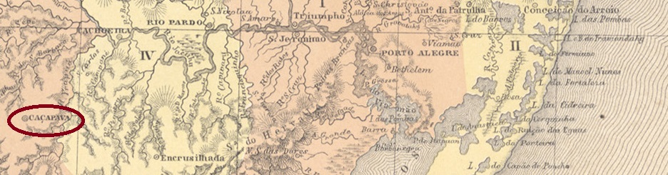
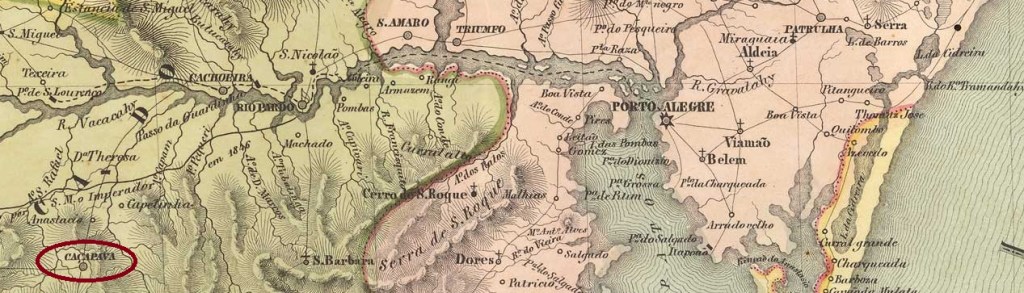
Caçapava (formerly also spelled Cassapava) means forest clearing in the Tupi-Guarani language. The chapel of N. Sra. de Assunção de Caçapava was built in July 1800, belonged to the Vila de Cachoeira and was located 260 km west of the later provincial capital Porto Alegre. It was elevated to vila status in October 1831 and became in January 1839 the capital of the Piratini Republic, proclaimed by the Farroupilha revolutionaries. After the end of the uprising in 1845, some calm returned and since December 1885 Caçapava has been a town, called Caçapava do Sul since December 1944, as opposed to Caçapava in the state of São Paulo.

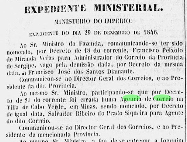
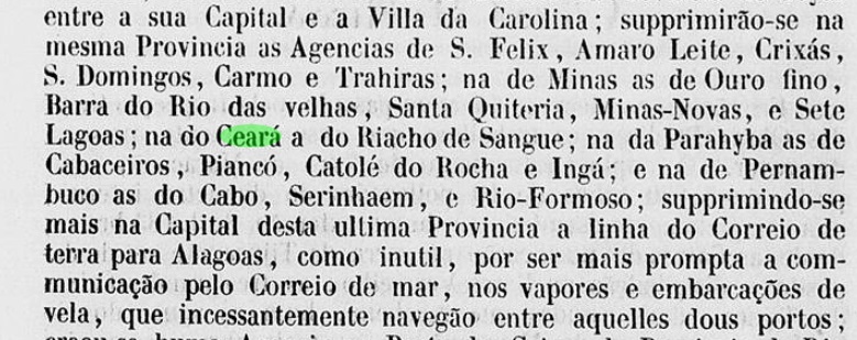
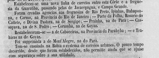
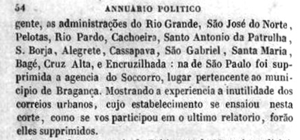
Three creation dates have been found for the local post office. First in 1831, as Nova Monteiro writes in Administrações e Agencias Postaes do Brasil Imperio (Brasil Filatelico/RJ, 1934-5; reprinted by SPP 1994-1999). Then in 1833, as indicated in the Directory of Imperial Post Offices (Tabella das Agencias do Correio do Imperio, Rio de Janeiro, 1885). And finally, around 1845, after the end of the Farroupilha uprising, as indicated in the Official Yearbook 1846:

Annuario Politico, Historico e Estatistico do Brazil, 1846

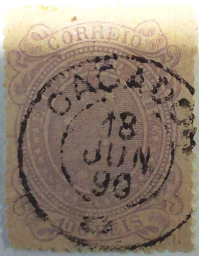
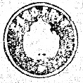
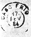
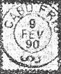
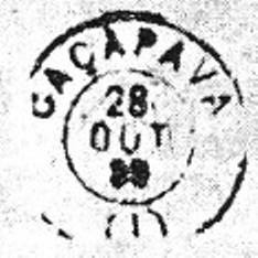
The first postmark is CRS-0050a, which also occurs in sepia and can be seen in the RHM catalogue under P-RS-04. However, the illustration there shows some differences from the actual cancel (José A. Junges coll.):

CRS-0050a (RHM P-RS-04, recte JJ) 1831ff

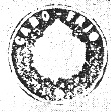
After the peace of 1845, it took some time for the official postmarks to arrive. The postal agency had to bridge the waiting time with handwritten marks:

1866ff (image from the internet)

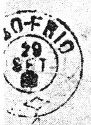
The next postmark CRS-0050b is not yet confirmed, but according to R. Koester (Carimbologia VII) it is assumed to belong to the province of Rio Grande do Sul:

CRS-0050b (RK) 1886-1896
Villiers de l’Ile Adam: Carta (…) da Provincia de São Pedro do Sul, 1847

Anderer Name: Caçapava do Sul (1943)

Caçapava (früher auch Cassapava geschrieben) bedeutet in der Sprache der Tupi-Guarani Waldlichtung. Die Kapelle der N. Sra. de Assunção de Caçapava wurde im Juli 1800 errichtet, gehörte zur Vila de Cachoeira und lag 260 km westlich der späteren Provinzhauptstadt Porto Alegre. Im Oktober 1831 wurde sie zur Vila erhoben und im Januar 1839 zur Hauptstadt der von den Farroupilha-Revolutionären ausgerufenen Piratini-Republik. Nach dem Ende des Aufstandes 1845 kehrte etwas Ruhe ein, und seit Dezember 1885 ist Caçapava eine Stadt, die seit Dezember 1944 Caçapava do Sul heißt, im Gegensatz zu Caçapava im Bundesstaat São Paulo.

Für das örtliche Postamt wurden drei Gründungsdaten gefunden. Zuerst 1831, wie Nova Monteiro in Administrações e Agencias Postaes do Brasil Imperio (Brasil Filatelico/RJ, 1934-5; Nachdruck SPP 1994-1999) schreibt. Dann 1833, wie im Verzeichnis der kaiserlichen Postämter (Tabella das Agencias do Correio do Imperio, Rio de Janeiro, 1885) angegeben. Und schließlich um 1845, nach dem Ende des Farroupilha-Aufstandes, wie aus dem Amtlichen Jahrbuch 1846 hervorgeht:

Annuario Politico, Historico e Estatistico do Brazil, 1846

Der erste Poststempel ist CRS-0050a, der auch in Sepia vorkommt und im RHM-Katalog unter P-RS-04 zu sehen ist. Die Abbildung dort weist jedoch einige Unterschiede zum tatsächlichen Stempel (Samml. José A. Junges) auf:

CRS-0050a (RHM P-RS-04, recte JJ) 1831ff

Nach dem Frieden von 1845 dauerte es einige Zeit, bis die offiziellen Poststempel eintrafen. Die Postagentur musste die Wartezeit mit handschriftlichen Entwertungen überbrücken:

1866ff (Abbildung aus dem Internet)

Der nächste Stempel CRS-0050b ist noch nicht bestätigt, wird aber nach R. Koester (Carimbologia VII) als zur Provinz Rio Grande do Sul gehörig vermutet:

CRS-0050b (RK) 1886-1896
Categories
Carimbologia C-D

Caçador, Rio de Janeiro (CRJ-0220)

agenciaspostais.com.br

Text update of August 18, 2023

Another name: Ibituporanga (1943)

This is another place that received a post office for no good reason. Caçador (Hunter) was the name of a small hamlet 80 km west of Rio de Janeiro, at the beginning of the Royal Road (Estrada Real) of the Serra da Calçada, which connected the imperial domain of Santa Cruz with the province of São Paulo. It was only in November 1926 that Caçador became a district of the Município of Itaguahy, which has been called Ibituporanga since December 1943. The word means Beautiful Mountain in the Tupi language.

As the Rio press reported, there had been a post office there since February 1889:

Jornal do Commercio, 27.02.1889

According to Paulo Novaes (agenciaspostais.com.br), the post office was closed at the end of 1943.

In the meantime, a postmark from 1890 has appeared in the Fuad Ferreira Fo. collection:

CRJ-0220a (FF) 1890

Otherwise, the CRJ-0220b postmark can be seen in R. Koester’s Carimbologia VII without further details:

CRJ-0220b (RK)
Google Maps

Textaktualisierung vom 18. August 2023

Anderer Name: Ibituporanga (1943)

Auch dies ist ein Ort, der ohne triftigen Grund ein Postamt erhielt. Caçador (Jäger) war der Name eines kleinen Weilers 80 km westlich von Rio de Janeiro, am Anfang der Königlichen Straße (Estrada Real) der Serra da Calçada, die die kaiserliche Domäne Santa Cruz mit der Provinz São Paulo verband. Erst im November 1926 wurde Caçador ein Bezirk des Município von Itaguahy, der seit Dezember 1943 Ibituporanga heißt. Das Wort bedeutet in der Tupi-Sprache Schöner Berg.

Wie die Presse von Rio berichtete, gab es dort seit Februar 1889 ein Postamt:

Jornal do Commercio, 27.02.1889

Laut Paulo Novaes (agenciaspostais.com.br) wurde das Postamt Ende 1943 geschlossen.

Inzwischen ist in der Sammlung Fuad Ferreira Fo. ein Poststempel von 1890 aufgetaucht:

CRJ-0220a (FF) 1890

Ansonsten ist der Siegelstempel CRJ-0220b in R. Koesters Carimbologia VII ohne weitere Angaben zu sehen:

CRJ-0220b (RK)
Categories
Carimbologia C-D

Cabuçu, Município Neutro (CMN-0065)

Mappa do Municipio Neutro, ca. 1875

See also Rio da Prata de Cabuçu (RMN-0065)

The word Cabuçu in its various spellings is of Indian origin (Tupi) and has two main meanings. The botanical interpretation would be a shrub, also called guajabara in Brazil (Coccoloba peltata, family Polygonaceae); the zoological interpretation would be a large wasp.

Coccoloba peltata

Rio da Prata do Cabuçu (= Silver River of Cabuçu) was a small settlement near Campo Grande on the western edge of the Município Neutro (= Neutral District) in the province of Rio de Janeiro, which had grown out of a large coffee and sugar cane plantation. According to Paulo Novaes (agenciaspostais.com.br), there were three post offices with Cabuçu in Rio province, but Rio da Prata do Cabuçu was the only one already active in the Empire. The post office was founded in May 1882, as introduced in the press:

Jornal do Commercio, 06.05.1882

Although the agency was in operation until about 1963, the only postmark, CMN-0065a, with the imperial seal was shown in Carimbologia VII by R. Koester:

CMN-0065a (RK) 1890ff
agenciaspostais.com.br

Siehe auch Rio da Prata de Cabuçu (RMN-0065)

Das Wort Cabuçu in seinen verschiedenen Schreibweisen ist indianischen Ursprungs (Tupi) und hat zwei Hauptbedeutungen. Die botanische Deutung wäre ein Strauch, der in Brasilien auch Guajabara genannt wird (Coccoloba peltata, Familie Polygonaceae); die zoologische Deutung wäre eine große Wespe.

Coccoloba peltata

Rio da Prata do Cabuçu (= Silberfluss von Cabuçu) war eine kleine Siedlung bei Campo Grande am westlichen Rand des Município Neutro (= Neutraler Bezirk) in der Provinz Rio de Janeiro, die aus einer großen Kaffee- und Zuckerrohrplantage hervorgegangen war. Laut Paulo Novaes (agenciaspostais.com.br) gab es drei Postämter mit Cabuçu in der Provinz Rio, aber Rio da Prata do Cabuçu war das einzige, das bereits im Kaiserreich aktiv war. Das Postamt wurde im Mai 1882 gegründet und der erste Angestellte wurde sofort in der Presse vorgestellt:

Jornal do Commercio, 16.05.1882

Obwohl die Agentur bis etwa 1963 in Betrieb war, wurde der einzige Stempel, CMN-0065a, mit dem kaiserlichen Siegel von R. Koester in Carimbologia VII gezeigt:

CMN-0065a (RK) 1890ff
Categories
Carimbologia C-D

Cabrobó, Pernambuco (CPE-0150)

Atlas do Imperio do Brasil, 1868

Other names: Brejão de Santa Cruz, Belém de Cabrobó

The old settlement of Brejão de Santa Cruz belonged to the Vila de Boa Vista and was situated on the north bank of the São Francisco, 530 km west of the later provincial capital Recife. It was elevated to freguesia status in November 1876 and to villa status in May 1854. In May 1924, Cabrobó belonged to the Município Belém do Cabrobó, when the last was elevated to a town. Cabrobó has been an independent município again since September 1928.

As Nova Monteiro writes in Administrações e Agencias Postaes do Brasil Imperio (Brasil Filatelico/RJ, 1934-5; Reprint SPP 1994-1999), there had been a post office there since July 1857, which is confirmed by the report of the General Postal Direction for 1858:

Relatorio da Diretoria Geral dos Correios, 1858

The only postmark in the Empire so far is the French type CPE-0150b (illustration Claudio Coelho): in this double circle – which also exists in red – CABROBÓ is written at the top, the typical star in brackets at the bottom. The dates were occasionally inscribed by hand, the ones known so far range from about 1884 to 1890.

Villiers de l’Ile Adam: Carta (…) das Provincias de Pernambuco, Alagoas e Sergipe, 1848

Andere Namen: Brejão de Santa Cruz, Belém de Cabrobó

Die alte Siedlung Brejão de Santa Cruz gehörte zur Vila de Boa Vista und lag am Nordufer des São Francisco, 530 km westlich der späteren Provinzhauptstadt Recife. Im November 1876 wurde der Ort zur Freguesia und im Mai 1854 zur Villa erhoben. Im Mai 1924 gehörte Cabrobó zum Município von Belém do Cabrobó, als letzter zur Stadt erhoben wurde. Seit September 1928 ist Cabrobó wieder ein eigenständiger Município.

Wie Nova Monteiro in Administrações e Agencias Postaes do Brasil Imperio (Brasil Filatelico/RJ, 1934-5; Reprint SPP 1994-1999) schreibt, gab es dort seit Juli 1857 ein Postamt, was durch den Bericht der Allgemeinen Postdirektion für 1858 bestätigt wird:

Relatorio da Diretoria Geral dos Correios, 1858

Der bisher einzige Poststempel im Kaiserreich ist der französische Typ CPE-0150b (Abb. Claudio Coelho): in diesem Doppelkreis – den es auch in rot gibt – steht oben CABROBÓ, unten der typische Stern in Klammern. Die Jahreszahlen wurden gelegentlich von Hand eingetragen, die bisher bekannten reichen von ca. 1884 bis 1890.

Categories
Carimbologia C-D

Cabreuva, São Paulo (CSP-0205)

Atlas do Imperio do Brasil, 1868

The Freguesia de N. Sra. da Piedade de Cabreuva was founded in December 1830 and was located on the east bank of the Tietê in the Município of Itu, about 80 km from the provincial capital of São Paulo. It became a villa in March 1859 and a town in December 1906.

The local post office was created in October 1872, according to the regional press:

Diario de São Paulo, 06.12.1872

Two double-circle postmarks from the imperial period were found. CSP-0205a (Coll. Níkolas T. Moura) bears the inscription CABRIUVA at the top, with an inside date of 1876. The French type CSP-0205b (ill. Mário Celso Orsi Jr.) bears the inscription CABREUVA above and the typical star in brackets below. The dates in the centre have so far been found for the period 1888-1901.

Villiers de l’Ile Adam: Carta (…) da Provincia de São Paulo, 1847

Die Freguesia de N. Sra. da Piedade de Cabreuva wurde im Dezember 1830 gegründet und lag am Ostufer des Tietê im Município von Itu, etwa 80 km von der Provinzhauptstadt São Paulo entfernt. Im März 1859 wurde es zur Villa und im Dezember 1906 zur Stadt.

Das örtliche Postamt wurde im Oktober 1872 ins Leben gerufen, wie die regionale Presse berichtet:

Diario de São Paulo, 06.12.1872

Es wurden zwei Doppelkreis-Poststempel aus der Kaiserzeit gefunden. CSP-0205a (Samml. Níkolas T. Moura) trägt oben die Inschrift CABRIUVA und innen ein Datum aus 1876. Der französische Typ CSP-0205b (Abb. Mário Celso Orsi Jr.) trägt oben die Inschrift CABREUVA und unten den typischen Stern in Klammern. Die Jahreszahlen in der Mitte wurden bisher für den Zeitraum 1888-1901 gefunden.

Categories
Carimbologia C-D

Cabo Verde, Minas Gerais (CMG-0425)

Atlas do Imperio do Brasil, 1868

Text update of July 9, 2023

Another name: N. Sra. de Assunção

At its foundation in 1766, this Arraial was called Nossa Senhora da Assunção and was situated 470 km south of the later provincial capital Ouro Preto, close to the border with São Paulo. Around 1768, Cabo Verde was declared a freguesia, which was placed under the município of Jacuhy around 1829. In March 1846, Cabo Verde became a villa, only to be downgraded to freguesia again four years later, this time to the município of Caldas. In October 1866, the status as a villa was regained and in November 1877 Cabo Verde became a town. 

Two foundation dates were also found for the local post office. The first in December 1846, according to the capital’s press:

Gazeta Official/RJ, 08.01.1847

The agency was closed in December 1855, according to Aureo G. Santos (Agências de Correio Criadas e Suprimidas 1851, 1855, 1856 e 1857, in Brasil Filatélico 181, Rio de Janeiro, 1977), but was reopened a year later, as indicated in the Directory of Imperial Post Offices (Tabella das Agencias do Correio do Imperio, Rio de Janeiro, 1885).

Aureo Santos (Brasil Filatélico 181)

The oldest postmark so far is CMG-0425b (image from the Internet), which was previously seen with internal data from 1887 to 1897. This double circle has the inscription CABO=VERDE at the top. Below is a diamond ornament consisting of four small diamonds.

Villiers del’Ile Adam: Carta (…) da Provincia de Minas Geraes, 1849

Textaktualisierung am 9. Juli 2023

Anderer Name: N. Sra. de Assunção

Bei der Gründung 1766 hieß dieser Arraial Nossa Senhora da Assunção und lag 470 km südlich der späteren Provinzhauptstadt Ouro Preto, nahe der Grenze zur Provinz São Paulo. Um 1768 wurde Cabo Verde zur Freguesia ernannt, die um 1829 dem Município von Jacuhy unterstellt wurde. Im März 1846 wurde Cabo Verde zur Villa, um vier Jahre später wieder zur Freguesia herabgestuft zu werden, diesmal zum Município von Caldas. Im Oktober 1866 wurde der Status als Villa wiedererlangt und im November 1877 wurde Cabo Verde eine Stadt. 

Auch für das örtliche Postamt wurden zwei Gründungsdaten gefunden. Die erste im Dezember 1846, wie aus der Presse der Hauptstadt hervorgeht:

Gazeta Official/RJ, 08.01.1847

Die Agentur wurde im Dezember 1855 geschlossen, so Aureo G. Santos (Agências de Correio Criadas e Suprimidas 1851, 1855, 1856 e 1857, in Brasil Filatélico 181, Rio de Janeiro, 1977), wurde aber ein Jahr später wieder eröffnet, wie im Verzeichnis der kaiserlichen Postämter (Tabella das Agencias do Correio do Imperio, Rio de Janeiro, 1885) angegeben.

Aureo Santos (Brasil Filatélico 181)

Der bisher älteste Poststempel ist CMG-0425b (Abb. aus dem Internet), der bisher mit internen Daten von 1887 bis 1897 zu sehen war. In diesem Doppelkreis steht oben die Inschrift CABO=VERDE. Unten befindet sich ein Rauten-Ornament aus vier kleinen Rauten.

Categories
Carimbologia C-D

Cabo, Pernambuco (CPE-0145)

Atlas do Imperio do Brasil, 1868

Other names: Cabo de Sto. Agostinho, Santo Agostinho do Cabo

The Freguesia of Cabo de Santo Agostinho was founded in September 1662 and was located on the south bank of the Pirapama, a good 30 km south of the later provincial capital of Recife. The place was declared a villa in November 1811, but was demoted to the Freguesia of Recife in March 1846 and only regained its political autonomy in July 1877, now as the town of Santo Agostinho do Cabo. Around 1910, the original place name Cabo de Santo Agostinho returned.

Again, two foundation dates for the local post office were found. Once in March 1829, as Nova Monteiro writes in Administrações e Agencias Postaes do Brasil Imperio (Brasil Filatelico/RJ, 1934-5; reprint SPP 1994-1999). In January 1851, the agency was closed, as registered by Aureo G. Santos (Agências de Correio Criadas e Suprimidas 1851, 1855, 1856 e 1857, in Brasil Filatélico 181, Rio de Janeiro, 1977):

Aureo G. Santos (op. cit.)

The post office reopened in September 1854, as reported in the regional press:

Diario de Pernambuco, 07.10.1854

The oldest postmark so far is the French type CPE-0145c (Coll. Marco Morel), which was already seen with internal data from about 1884 until around 1887. It was followed by the somewhat larger double circle CPE-0145d (Coll. Luís C. Fritzen), which shows only CABO at the top and whose only copy bears a date of 1891 in the centre.

Carta Corographica da Provincia de Pernambuco, 1880

Andere Namen: Cabo de Sto. Agostinho, Santo Agostinho do Cabo

Die Freguesia von Cabo de Santo Agostinho wurde im September 1662 gegründet und lag am Südufer des Pirapama, gut 30 km südlich der späteren Provinzhauptstadt Recife. Der Ort wurde im November 1811 zur Villa erklärt, im März 1846 jedoch zur Freguesia von Recife degradiert und erhielt erst im Juli 1877 seine politische Autonomie zurück, nun als Stadt Santo Agostinho do Cabo. Um 1910 kehrte der ursprüngliche Ortsname Cabo de Santo Agostinho zurück.

Auch hier wurden zwei Gründungsdaten für das örtliche Postamt gefunden. Einmal im März 1829, wie Nova Monteiro in Administrações e Agencias Postaes do Brasil Imperio (Brasil Filatelico/RJ, 1934-5; Nachdruck SPP 1994-1999) schreibt. Im Januar 1851 wurde die Agentur geschlossen, wie Aureo G. Santos (Agências de Correio Criadas e Suprimidas 1851, 1855, 1856 e 1857, in Brasil Filatélico 181, Rio de Janeiro, 1977) registrierte:

Aureo G. Santos (op. cit.)

Dann eröffnete das Postamt wieder im September 1854, wie die regionale Presse berichtete:

Diario de Pernambuco, 07.10.1854

Der bisher älteste Poststempel ist der französische Typ CPE-0145c (Samml. Marco Morel), der schon von ca. 1884 bis um 1887 mit inneren Daten zu sehen war. Ihm folgte der etwas größere Doppelkreis CPE-0145d (Samml. Luís C. Fritzen), der oben nur CABO zeigt und dessen einziges Exemplar ein Datum von 1891 in der Mitte trägt.

Categories
Carimbologia C-D

Cabo Frio, Rio de Janeiro (CRJ-0215)

Atlas do Imperio do Brasil, 1868

Another name: Santa Helena

This is believed to be one of the oldest towns in Brazil, founded as Santa Helena do Cabo Frio in November 1615, shortly after the French invaders were defeated after decades of occupation. Curiously, Cabo Frio did not become a freguesia until much later (1678).

Two foundation dates have been found for the local post office. First in April 1827, as Nova Monteiro writes in Administrações e Agencias Postaes do Brasil Imperio (Brasil Filatelico/RJ, 1934-5; reprinted by SPP 1994-1999). Then in 1829, as shown in the Directory of Imperial Post Offices (Tabella das Agencias do Correio do Imperio, Rio de Janeiro, 1885). The oldest stamp CRJ-0215a, which also exists in sepia and is already illustrated in the RHM catalogue under P-RJ-003, is from the pre-philatelic period:

CRJ-0215a (RHM P-RJ-003) also sepia

It was followed by CRJ-0215b, which also occurs in red, brown, blue and green, was used between about 1843 and 1882 and is known by Paulo Ayres (Catálogo de Carimbos Brasil-Império, S. Paulo, 1937, 1942) with no. 1248:

CRJ-0215b (P.A. 1248) 1843ff-1882ff

This was followed by three stamps as double circles, already presented by R. Koester in Carimbologia VII:

CRJ-0215c (RK) 1882-1884
CRJ-0215d (RK) 1888-1890
CRJ-0215e (RK) 1890-1902

Two postmarks with the imperial seal are also known from Cabo Frio, also by R. Koester:

CRJ-0215f (RK)
CRJ-0215g (RK)

More recently, James Dingler and Klerman W. Lopes have registered two mute cancellations from Cabo Frio in Mute Cancellations of the Brazil Empire / Carimbos Mudos do Brasil Império (Brazil Philatelic Association, Rio de Janeiro, 2000) with numbers 439 and 2944:

BPA 439, 2944
Almanak Laemmert, 1866

Anderer Name: Santa Helena

Es wird angenommen, dass dies eine der ältesten Städte Brasiliens ist, gegründet als Santa Helena do Cabo Frio im November 1615, kurz nachdem die französischen Invasoren nach jahrzehntelanger Besetzung besiegt worden waren. Merkwürdigerweise wurde Cabo Frio erst viel später (1678) eine Freguesia.

Für das örtliche Postamt wurden zwei Gründungsdaten gefunden. Zuerst im April 1827, wie Nova Monteiro in Administrações e Agencias Postaes do Brasil Imperio (Brasil Filatelico/RJ, 1934-5; Nachdruck SPP 1994-1999) schreibt. Dann 1829, wie aus dem Verzeichnis der kaiserlichen Postämter (Tabella das Agencias do Correio do Imperio, Rio de Janeiro, 1885) hervorgeht. Aus der Vor-Philatelie stammt der älteste Stempel CRJ-0215a, der auch in Sepia existiert und bereits im RHM-Katalog unter P-RJ-003 abgebildet ist:

CRJ-0215a (RHM P-RJ-003) auch sepia

Ihm folgte CRJ-0215b, der auch in rot, braun, blau und grün vorkommt, zwischen ca. 1843 und 1882 verwendet wurde und durch Paulo Ayres (Catálogo de Carimbos Brasil-Império, S. Paulo, 1937, 1942) mit Nr. 1248 bekannt ist:

CRJ-0215b (P.A. 1248) 1843ff-1882ff

Danach folgten drei Stempel als Doppelkreise, die R. Koester bereits in Carimbologia VII vorgestellt hat:

CRJ-0215c (RK) 1882-1884
CRJ-0215d (RK) 1888-1890
CRJ-0215e (RK) 1890-1902

Aus Cabo Frio sind auch zwei Poststempel mit dem kaiserlichen Siegel bekannt, ebenfalls von R. Koester:

CRJ-0215f (RK)
CRJ-0215g (RK)

Zuletzt haben James Dingler und Klerman W. Lopes zwei stumme Abstempelungen von Cabo Frio in Mute Cancellations of the Brazil Empire / Carimbos Mudos do Brasil Império (Brazil Philatelic Association, Rio de Janeiro, 2000) mit den Nummern 439 und 2944 registriert:

BPA 439, 2944
Categories
Carimbologia C-D

Cabedello (train station/Bahnhof), Paraíba (CPB-0075)

Atlas do Imperio do Brasil, 1868

Another name: Margareta

The history of the village begins in 1584 with the construction of the fortress of Santa Catarina at the tip of the peninsula, 15 km north of the later provincial capital Parahyba (now João Pessoa). 60 years later, the fortress was taken by Dutch corsairs, who named it Margareta. After the liberation, the population of the place grew slowly, and Cabedello probably became a district of Parahyba only at the end of the 19th century. The place was the most important commercial port in the province.

The inauguration of the railway station at the end of the Cabedello line by the E.F. Conde d’Eu railway company in March 1889 changed the situation: in March Cabedello became a município. This status was lost in November 1928, but returned in December 1956, when Cabedelo (as it is now written) became the smallest and least populous município in the state of Paraíba.  

Cabedello station, around 1970 (estacoesferroviarias.com.br)

The railway line went to the Great Western Railway in 1901, to Rede Ferroviária do Nordeste in 1950, to Rede Ferroviária Federal in 1975, and since 1997 has belonged to Cia. Brasileira de Transportes Urbanos (CBTU).

Cabedello station, 2021 (Photo: Rodrigo Henrique in estacoesferroviarias.com.br)

R. Koester writes in Carimbologia VII that the station post office was created in August 1889. This is not quite correct: on 5 August 1889, a letter from the postal administration in Rio went to the provincial administration in Parahyba. It was a reply to an enquiry made in March of that year about how the postal agent was to be remunerated.

Boletim Postal V, September 1889

Accordingly, the decision to establish a postal agency in Cabedello must have been made earlier – and its commissioning later. The oldest postmark is BPB-0075a and was already shown in R. Koester’s Carimbologia VII:

BPB-0075a (RK)
Sociedade Geologica e Mineralogica, 1910

Anderer Name: Margareta

Die Geschichte des Ortes beginnt 1584 mit dem Bau der Festung Santa Catarina an der Spitze der Halbinsel, 15 km nördlich der späteren Provinzhauptstadt Parahyba (heute João Pessoa). 60 Jahre später wurde die Festung von holländischen Korsaren eingenommen, die sie Margareta nannten. Nach der Befreiung wuchs die Bevölkerung des Ortes nur langsam, und wahrscheinlich wurde Cabedello erst Ende des 19. Jahrhunderts zu einem Distrikt von Parahyba. Der Ort war der wichtigste Handelshafen der Provinz.

Mit der Einweihung des Bahnhofs am Ende der Abzweigung Cabedello durch die Eisenbahngesellschaft E.F. Conde d’Eu im März 1889 änderte sich die Situation: Im März wurde Cabedello zu einem Município. Dieser Status ging im November 1928 verloren, kehrte aber im Dezember 1956 wieder zurück, als Cabedelo (wie es jetzt geschrieben wird) das kleinste und bevölkerungsärmste Município im Bundesstaat Paraíba wurde.  

Bahnhof Cabedello, um 1970 (estacoesferroviarias.com.br)

Die Bahnlinie ging 1901 an die Great Western Railway, 1950 an die Rede Ferroviária do Nordeste, 1975 an die Rede Ferroviária Federal und gehört seit 1997 der Cia. Brasileira de Transportes Urbanos (CBTU).

Bahnhof Cabedello, 2021 (Foto: Rodrigo Henrique in estacoesferroviarias.com.br)

R. Koester schreibt in Carimbologia VII, dass das Bahnhofspostamt im August 1889 gegründet wurde. Das ist nicht ganz richtig: Am 5. August 1889 ging ein Schreiben der Postverwaltung in Rio an die Provinzverwaltung nach Parahyba. Es handelte sich um eine Antwort auf eine Anfrage vom März d.J., wie der Postagent zu entlohnen sei.

Boletim Postal V, September 1889

Demnach muss die Entscheidung für eine Postagentur in Cabedello früher gefallen sein – und ihre Inbetriebnahme später. Der älteste Poststempel ist BPB-0075a und wurde bereits in R. Koesters Carimbologia VII gezeigt:

BPB-0075a (RK)
Categories
Carimbologia C-D

Cabaceiras, Paraíba (CPB-0070)

Atlas do Imperio do Brasil, 1868

The Freguesia de N. Sra. da Conceição das Cabaceiras was founded in August 1833 and was located near Villa Nova da Rainha (today: Campina Grande) on the north bank of the Parahyba, 200 km west of the provincial capital Parahyba do Norte (today: João Pessoa). In June 1835, the place became Vila Federal de Cabaceiras, and since February 1870, the abbreviated place name Vila (or town) de Cabaceiras has been in use.

In January 1836, it was decided to establish a local post office, as Nova Monteiro writes in Administrações e Agencias Postaes do Brasil Imperio (Brasil Filatelico/RJ, 1934-5; reprint SPP 1994-1999). The agency was closed around 1850, but reopened about three years later – according to reports from the imperial ministry:

Relatorio do Ministerio do Imperio/1850
Relatorio do Ministerio do Imperio/1853

The only imperial postmark so far is CPB-0070b (Fig. Jorge L. Pedreira): a double circle with the inscription CABACEIRAS at the top and internal dates from 1881 to 1892.

Villiers de l’Ile Adam: Carta (…) das Provincias do Rio Grande do Norte e Parahiba, 1848

Die Freguesia de N. Sra. da Conceição das Cabaceiras wurde im August 1833 gegründet und lag bei Villa Nova da Rainha (heute: Campina Grande) am Nordufer des Parahyba, 200 km westlich der Provinzhauptstadt Parahyba do Norte (heute: João Pessoa). Im Juni 1835 wurde der Ort zur Vila Federal de Cabaceiras, und seit Februar 1870 ist der abgekürzte Ortsname Vila (oder Stadt) de Cabaceiras gebräuchlich.

Im Januar 1836 wurde die Einrichtung eines örtlichen Postamtes beschlossen, wie Nova Monteiro in Administrações e Agencias Postaes do Brasil Imperio (Brasil Filatelico/RJ, 1934-5; Nachdruck SPP 1994-1999) schreibt. Die Agentur wurde um 1850 geschlossen, aber etwa drei Jahre später – nach Berichten des kaiserlichen Ministeriums – wieder eröffnet:

Relatorio do Ministerio do Imperio/1850
Relatorio do Ministerio do Imperio/1853

Der bisher einzige kaiserliche Poststempel ist CPB-0070b (Abb. Jorge L. Pedreira): ein Doppelkreis mit der Inschrift CABACEIRAS oben und inneren Daten von 1881 bis 1892.