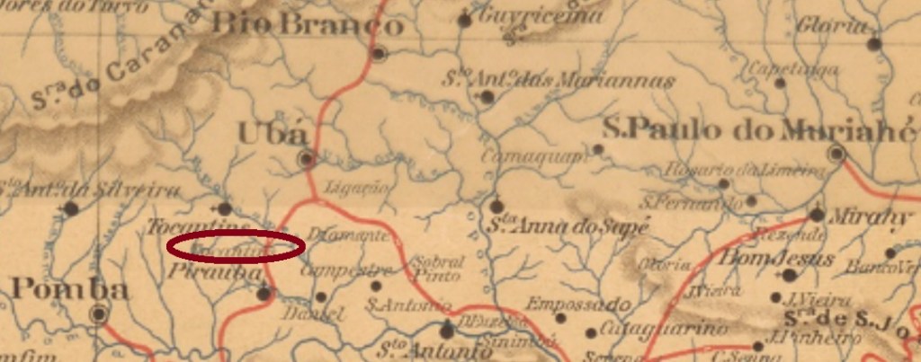
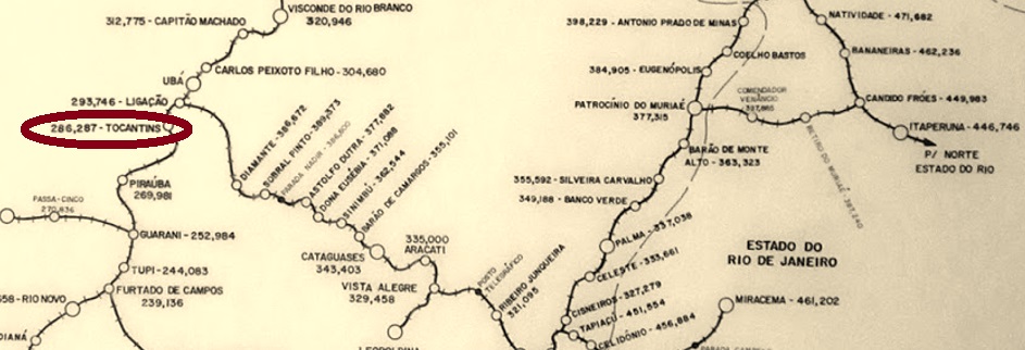
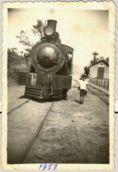
Tocantins railway station was inaugurated in July 1886 by the E.F. Leopoldina Railway Company and was located on the Caratinga Line in the district of São José de Tocantins, Município of Ubá, about 200 km southeast of the provincial capital Ouro Preto. The settlement around the railway station continued to grow and was elevated to the Município of Tocantins in December 1948. The railway line became Rede Ferroviária Federal S.A. in 1975 until its closure in 1994 (estacoesferroviarias.com.br). The station building is now used as housing.
in 1957 (Photo: Milton Palhares, in estacoesferroviarias.com.br)
The station post office was built shortly before the end of the Empire, in November 1889, as shown in the postal report (Boletim Postal) of the following month:
Boletim Postal No.8 (December 1889)
The postmark is TMG-3200a (Coll. José A. Junges): a double circle with the inscriptions TOCANTINS above and (MINAS) below. A specimen sighted, with a date from 1896 in its centre. For local stamps of S. José de Tocantins, see SMG-2435.
Estrada de Ferro Leopoldina
Siehe auch São José de Tocantins (SMG-2435)
Der Bahnhof Tocantins wurde im Juli 1886 durch die E.F. Leopoldina Bahngesellschaft eingeweiht und lag auf der Caratinga-Linie im Distrikt von São José de Tocantins, Município von Ubá, ca. 200 km südöstlich der Provinzhauptstadt Ouro Preto entfernt. Die Siedlung um den Bahnhof wuchs weiter und wurde im Dezember 1948 zum Município von Tocantins erhoben. Die Bahnlinie ging 1975 bis zur Stilllegung 1994 zur Rede Ferroviária Federal S.A. (estacoesferroviarias.com.br). Das Bahnhofsgebäude dient heute als Wohnraum.
1957 (Foto: Milton Palhares, in estacoesferroviarias.com.br)
Das Bahnhofspostamt entstand kurz vor dem Ende des Kaiserreichs, im November 1889, wie aus dem Postbericht (Boletim Postal) des folgenden Monats hervorgeht:
Boletim Postal Nr.8 (Dezember 1889)
Der Poststempel ist TMG-3200a (Samml. José A. Junges): ein Doppelkreis mit den Inschriften TOCANTINS oben und (MINAS) unten. Ein Exemplar gesichtet, mit einem Datum aus 1896 in seiner Mitte. Für Ortsstempel von S. José de Tocantins siehe SMG-2435.
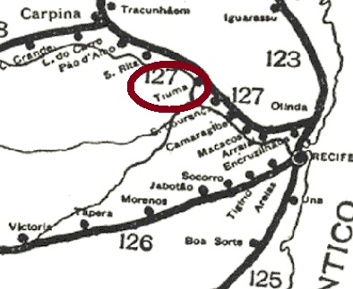
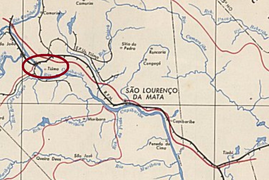
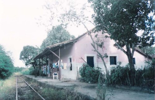
Tiuma station was inaugurated in October 1881 by the Great Western Railway Company, Northern Line, and was in the Município of São Lourenço da Mata, 30 km west of the provincial capital Recife. In 1950, the railway line became the property of Rede Ferroviária do Nordeste, and from 1975 until its closure in 1996, it belonged to Rede Ferroviária Federal S. A. (estacoesferroviarias.com.br). Today, the former station house is to be used as a residential building:
ca. 2009 (Photo: Sidney Correia, in estacoesferroviarias.com.br)
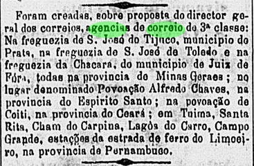
The station post office was created in October 1882, according to the Rio press:
O Globo/RJ, 28.10.1882
The oldest postmark so far is TPE-0645a (Coll. Ginaldo Bezerra da Silva): a double circle with the inscriptions TIUMA at the top and (PERNAMBUCO) at the bottom. The dates in the centre go from 1891 to at least 1894.
IBGE (in estacoesferroviarias.com.br)
Der Bahnhof Tiuma wurde im Oktober 1881 durch die Great Western Eisenbahngesellschaft, Nordlinie, eingeweiht und lag im Município von São Lourenço da Mata, 30 km westlich der Provinzhauptstadt Recife entfernt. 1950 ging die Bahnlinie in Besitz der rede Ferroviária do Nordeste, und von 1975 bis zur Stilllegung 1996 gehörte sie der Rede Ferroviária Federal S. A. (estacoesferroviarias.com.br). Heute soll das ehemalige Bahnhofsgebäude als Wohnhaus dienen:
ca. 2009 (Foto: Sidney Correia, in estacoesferroviarias.com.br)
Das Bahnhofspostamt entstand im Oktober 1882, wie die Rio-Presse mitteilt:
O Globo/RJ, 28.10.1882
Das bisher älteste Poststempel ist TPE-0645a (Samml. Ginaldo Bezerra da Silva): ein Doppelkreis mit den Inschriften TIUMA oben und (PERNAMBUCO) unten. Die Daten in der Mitte gehen von 1891 bis mindestens 1894.
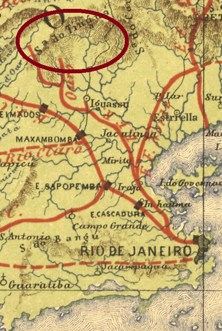
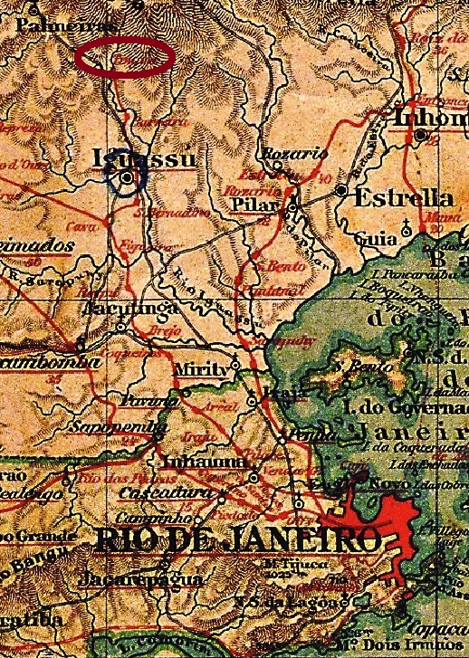
Tinguá station was inaugurated in 1883 by the E.F. do Rio d’Ouro railway company, Tinguá branch, in the Município of Nova Iguassú and was located 60 km northwest of the capital Rio de Janeiro. The railway line belonged to the E.F. Central do Brasil from 1928 until its closure. Today, Tinguá is a suburb of Nova Iguaçu.
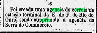
The station post office was created in July 1886, in succession to the Serra do Commercio post office, according to the Rio press:
Diario de Noticias, 17.07.1886
Paulo Novaes writes down a date from October of that year for this in agenciaspostais.com.br, but this would be the date when the post office was put into operation. So far, no imperial postmark from this station has appeared.
Almanak Laemmert, 1892
Siehe auch Serra do Commercio (SRJ-1585)
Der Bahnhof Tinguá wurde 1883 durch die E.F. do Rio d’Ouro Bahngesellschaft, Tinguá-Abzweigung, im Município von Nova Iguassú eingeweiht und lag 60 km nordwestlich der Hauptstadt Rio de Janeiro entfernt. Die Bahnlinie gehörte von 1928 bis zur Stilllegung zur E.F. Central do Brasil. Heute ist Tinguá ein Vorort der Stadt Nova Iguaçu.
Das Bahnhofspostamt entstand im Juli 1886, in der Nachfolge des Postamts Serra do Commercio, wie aus der Rio-Presse hervorgeht:
Diario de Noticias, 17.07.1886
Paulo Novaes schreibt dafür in agenciaspostais.com.br ein Datum aus Oktober des Jahres auf, das dürfte aber der Zeitpunkt der Inbetriebnahme des Postamts sein. Bisher ist kein kaiserlicher Poststempel aus diesem Bahnhof aufgetaucht.
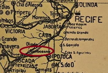
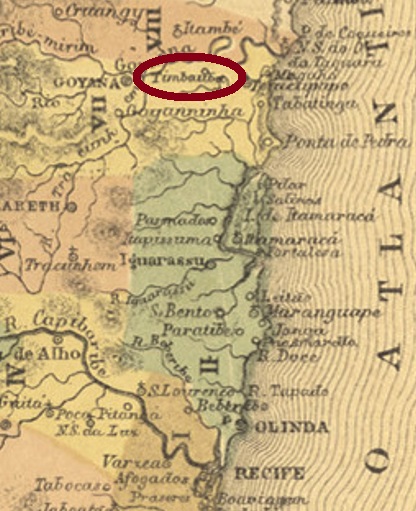
Carta Corographica da Provincia de Pernambuco, 1880
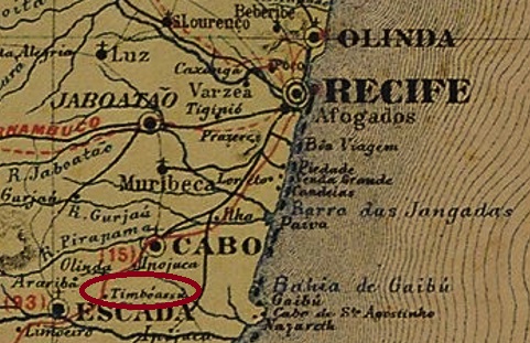
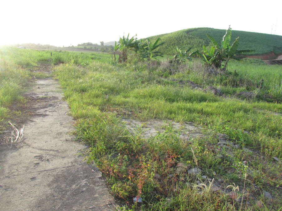
Timbó-Assú station was built in November 1860 in the fazenda of the same name near Escada by the E.F. do Recife ao São Francisco railway company (Southern line) and was located over 50 km southwest of Recife. The railway line went to the Great Western in 1901, to the Rede Ferroviaria do Nordeste in 1950 and to the Rede Ferroviária Federal S. A. from 1975 until its closure in 1996 (estacoesferroviarias.com.br). The station building has already been dismantled, only traces of the old railway line remain in the middle of the sugar cane plantation.
In 2019 (Photo: Sydney Correa, in estacoesferroviarias.com.br)
There was a railway station post office there from 1864, as the Directory of Imperial Post Offices (Tabella das Agencias do Correio do Imperio, Rio de Janeiro, 1885) tells us. Only one 19th century postmark has been found so far, probably not the oldest. TPE-0640b (Coll. José A. Junges) is a double circle with the inscriptions EST. DE TIMBÓ-ASSÚ above and (PERNAMo) below. The only specimen bears a date of 1891 in the centre.
Arthur D. Ribeiro: Estado de Pernambuco, 1924
Der Bahnhof Timbó-Assú wurde im November 1860 in der gleichnamigen Fazenda bei Escada durch die E.F. do Recife ao São Francisco Bahngesellschaft (Südlinie) gebaut und lag über 50 km südwestlich von Recife. Die Bahnlinie ging 1901 an die Great Western, 1950 an die Rede Ferroviária do Nordeste und von 1975 bis zur Stilllegung 1996 an die Rede Ferroviária Federal S. A. (estacoesferroviarias.com.br). Das Bahnhofsgebäude wurde bereits abgebaut, nur Spuren der alten Bahnlinie sind mitten in der Zuckerrohrplantage noch vorhanden.
2019 (Foto: Sydney Correa, in estacoesferroviarias.com.br)
Es gab dort ein Bahnhofspostamt ab 1864, wie uns das Verzeichnis der kaiserlichen Postämter (Tabella das Agencias do Correio do Imperio, Rio de Janeiro, 1885) verrät. Nur ein Poststempel des 19. Jahrhunderts wurde bisher gefunden, wohl nicht der älteste. TPE-0640b (Samml. José A. Junges) ist ein Doppelkreis mit den Inschriften EST. DE TIMBÓ-ASSÚ oben und (PERNAMo) unten. Das einzige Exemplar trägt in der Mitte ein Datum aus 1891.
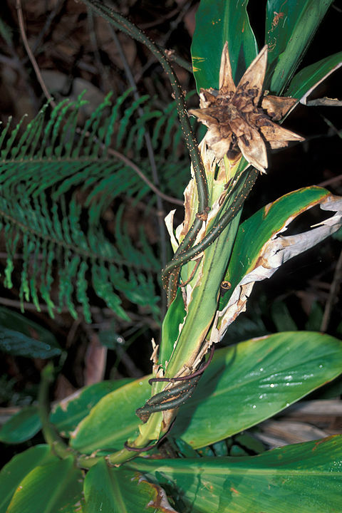
Timbó is the generic Indian name for many liana varieties in Brazil, which were used as anaesthetics for fishing due to their toxic ingredients:
Derris ellipitica (Photo: Kim & Forest Sparr, CC-BY 3.0)
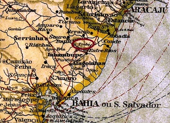
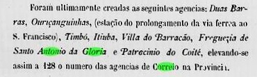
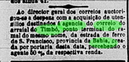
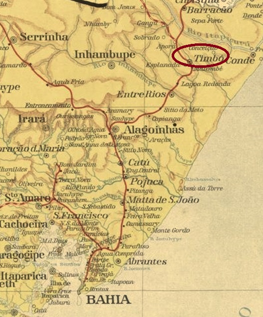
The Arraial of Timbó was a small settlement that emerged around 1850 and was located in the Município of Vila do Conde, over 160 km north of the provincial capital Salvador da Bahia. After the construction of the E.F. da Bahia ao São Francisco railway company towards the end of the Empire, the village grew rapidly, as it was initially located at the end of the rail line. However, with the decline of the railway, it soon shrank again and is now a suburb in the Município of Esplanada.
The local post office was established around the turn of the year 1876-77, according to the provincial president’s report for 1877:
Relatorio do Presidente da Provincia/BA 1877
The railway station, inaugurated at the end of March 1887, probably caused a move of the postal agency from the centre of the village to the rails, as can be deduced from a Rio press release:
Gazeta da Tarde/RJ, 31/03/1887
Three early postmarks were found, all with dates from the Republic. TBA-0735a (Coll. Luis C. Fritzen) is a plain double circle with the inscription TIMBÓ at the top. One copy was seen, dated 1890 in the centre. TBA-0736a (Coll.. FM) is a rectangular box stamp for ambulant mail, with the inscription AMB. TIMBÓ, found on stamps of the Southern Cross issue (1890ff). TBA-0735b (image from the Internet) is a double circle with the inscriptions TIMBÓ above and (BAHIA) below. The only specimen so far bears a date from 1902 in the centre.
Estado da Bahia, 1913
Textaktualisierung vom 24.05.2022
Timbó ist der allgemeine indianische Name für viele Lianensorten in Brasilien, die durch ihre giftigen Inhaltsstoffe als Betäubungsmittel für Fische verwendet wurden:
Derris ellipitica (Foto: Kim & Forest Sparr, CC-BY 3.0)
Der Arraial von Timbó war eine kleine Siedlung, die um 1850 entstanden ist und im Município von Vila do Conde lag, über 160 km nördlich von der Provinzhauptstadt Salvador da Bahia entfernt. Nach dem Bau der E.F. da Bahia ao São Francisco Eisenbahngesellschaft gegen Ende des Kaiserreichs wuchs der Ort schnell, da er zunächst am Ende der Bahnstrecke lag. Mit dem Niedergang des Bahnbetriebs schrumpfte er aber auch bald wieder und ist heute ein Vorort im Município von Esplanada.
Das örtliche Postamt wurde um die Jahreswende 1876-77 ins Leben gerufen, wie der Bericht des Provinzpräsidenten für 1877 mitteilt:
Relatorio do Presidente da Provincia/BA 1877
Der am Ende März 1887 eingeweihte Bahnhof verursachte wohl einen Umzug der Postagentur aus der Ortsmitte zu den Schienen, wie man aus der Rio-Presse entnehmen kann:
Gazeta da Tarde/RJ, 31.03.1887
Drei frühe Poststempel wurden gefunden, alle mit Daten aus der Republik. TBA-0735a (Samml. Luis C. Fritzen) ist ein schlichter Doppelkreis mit der Inschrift TIMBÓ oben. Ein Exemplar gesehen, datiert 1890 in der Mitte. TBA-0736a (Samml. FM) ist ein rechteckiger Kastenstempel für den ambulanten Postbetrieb, mit der Inschrift AMB. TIMBÓ, gefunden auf Marken der Ausgabe Kreuz des Südens (1890ff). TBA-0735b (Abb. aus dem Internet) ist ein Doppelkreis mit den Inschriften TIMBÓ oben und (BAHIA) unten. Das bisher einzige Exemplar trägt ein Datum aus 1902 in der Mitte.
Carta Corographica da Provincia de Pernambuco, 1880
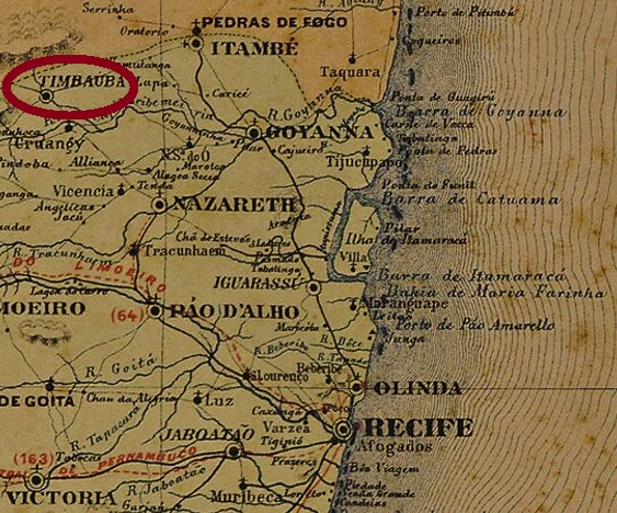
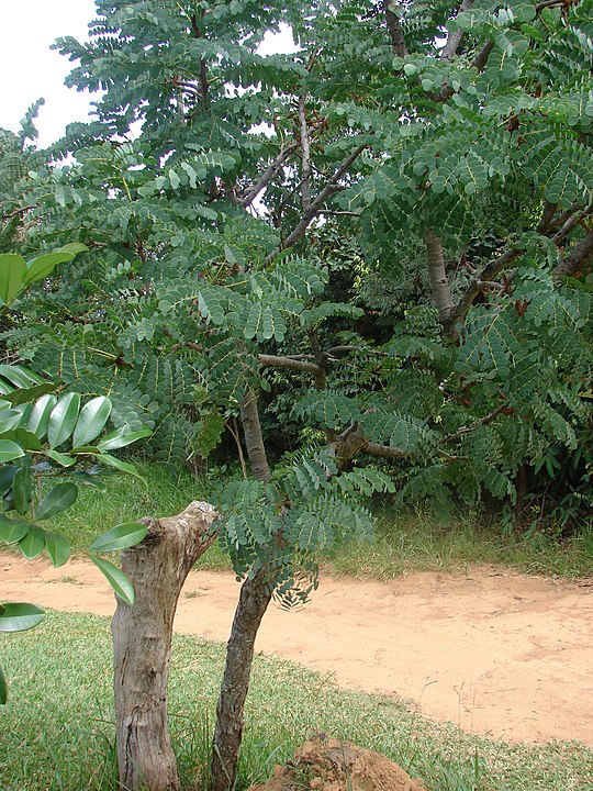
Timbauba (now spelled Timbaúba) was a district in the Município of Itambé from May 1853, located about 100 km northwest of the provincial capital Recife. In April 1879 it received administrative autonomy as a vila and has been a town since June 1884. The name refers to a plant of the Fabaceae family (Stryphnodendrum sp./Mart.):
The Directory of Imperial Post Offices (Tabella das Agencias do Correio do Imperio, Rio de Janeiro, 1885) lists the local post office as of 1873. However, postal operations did not start until July of the following year, according to the Pernambuco press:
Diario de Pernambuco, 16.07.1874
The imperial postal cancel is the French type TPE-0635a (Coll. José A. Junges): a small double circle, also available in lilac, with the inscription TIMBAUBA at the top and the small star between brackets at the bottom. The dates in the middle have been found so far for the period between about 1883 and at least 1891.
Atlas do Imperio do Brasil, 1868
Timbauba (heute Timbaúba geschrieben) war ab Mai 1853 ein Distrikt im Município von Itambé, der ca. 100 km nordwestlich der Provinzhauptstadt Recife entfernt lag. Im April 1879 erhielt der Ort die Verwaltungsautonomie als Vila und ist eine Stadt seit Juni 1884. Der Name bezeichnet eine Pflanze der Familie Fabaceae (Stryphnodendrum sp./Mart.):
Das Verzeichnis der kaiserlichen Postämter (Tabella das Agencias do Correio do Imperio, Rio de Janeiro, 1885) listet das örtliche Postamt ab 1873 auf. Allerdings startete der Postbetrieb erst im Juli des folgenden Jahres, wie die Presse aus Pernambuco berichtet:
Diario de Pernambuco, 16.07.1874
Der kaiserliche Posttempel ist der Französiche Typus TPE-0635a (Samml. José A. Junges): ein kleiner Doppelkreis, den es auch in lila gibt, mit der Inschrift TIMBAUBA oben und dem kleinen Stern zwischen Klammern unten. Die Daten in der Mitte wurden bisher für den Zeitraum zwischen ca. 1883 und mindestens 1891 gefunden.
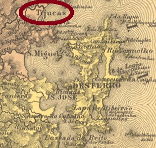
Villiers de l’Ile Adam: Carta (…) da Provincia de Santa Catharina, 1848
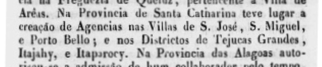
Other names: São Miguel de Tijucas Grandes, S. Sebastião das Tijucas
This locality was a district of Porto Belo from May 1848, situated on the north bank of the river of the same name, over 50 km north of the provincial capital of Desterro (now Florianópolis). Tijucas has been an independent município since April 1859.
The local post office had two operation periods. It opened for the first time around 1839, as can be read in the ministerial report for the following year:
Relatorio do Ministerio do Imperio/RJ, 1840
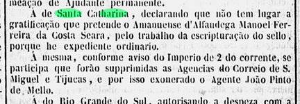
It was closed for the first time in March 1847, according to the Rio press:
Gazeta Official/RJ, 30/03/1847
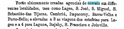
It seems it was not until 1875 that postal service resumed in Tijucas, as noted in the Provincial President’s Report for March 1876:
Relatorio do Presidente da Provincia/SC, 03/1876
The only postmark of this place so far comes from the second period. TSC-0260b (Coll. José A. Junges) is a double circle with the inscription TIJUCAS at the top and an ornament in lozenge below, formed by four small lozenges. The dates in the centre vary from 1880 to 1895.
Atlas do Imperio do Brasil, 1868
Andere Namen: São Miguel de Tijucas Grandes, S.Sebastião das Tijucas
Diese Ortschaft war ab Mai 1848 ein Distrikt von Porto Belo, der am Nordufer des gleichnamigen Flusses lag, gut 50 km nördlich der Provinzhauptstadt Desterro (heute Florianópolis) entfernt. Seit April 1859 ist Tijucas ein eigenständiger Município.
Das örtliche Postamt hatte zwei Betriebsperioden. Erstmals eröffnete es um 1839, wie im Ministerialbericht fürs folgende Jahr zu lesen ist:
Relatorio do Ministerio do Imperio/RJ, 1840
Im März 1847 wurde es erstmals geschlossen, wie aus der Presse in Rio hervorgeht:
Gazeta Official/RJ, 30.03.1847
Es scheint, erst 1875 wurde der Postbetrieb in Tijucas wieder aufgenommen, wie im Bericht des Provinzpräsidenten für März 1876 vermerkt wurde:
Relatorio do Presidente da Provincia/SC, 03/1876
Der bisher einzige Poststempel dieses Orts kommt aus der zweiten Periode. TSC-0260b (Samml. José A. Junges) ist ein Doppelkreis mit der Inschrift TIJUCAS oben und einem Ornament in Raute unten, das aus vier kleinen Rauten gebildet wird. Die Daten in der Mitte gehen von 1880 bis 1895.
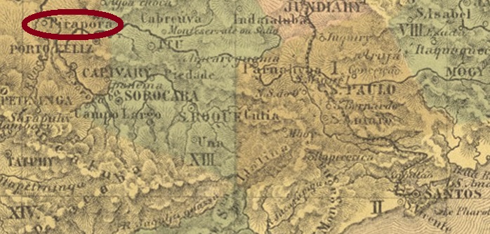
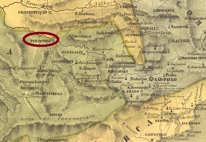
Other names: Santissima Trindade de Pirapora, Pirapora de Curuçá
This village was already in August 1811 a freguesia called Santissima Trindade de Pirapora (Most Holy Trinity of Pirapora), located directly on the river Tieté (today written Tietê) near Porto Feliz, 140 km northwest of the future provincial capital São Paulo. In March 1842, it became the Vila of Pirapora de Curuçá, which was then elevated to the status of a city in July 1867, albeit under the place name Tieté.
Two dates of origin for the local post office were found. First under Pirapora in December 1851, as both Nova Monteiro (Administrações e Agencias Postaes do Brasil Imperio, in Brasil Filatelico/RJ, 1934-5; Reprint SPP 1994-1999) and Reinhold Koester (Carimbologia XXXI) write. Then again in 1877, now under the later place name Tietê, as noted in the Directory of Imperial Post Offices (Tabella das Agencias do Correio do Imperio, Rio de Janeiro, 1885). Since this post office was still listed on a reward list for postal employees in October 1875, it was either closed shortly afterwards or there was a third, still unknown opening date:
Diario de São Paulo, 27 October 1875
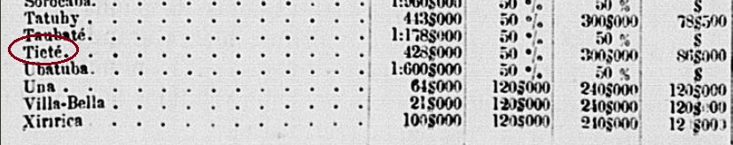
For postmarks with Pirapora, see Koester (Carimbologia XXI). The oldest postmark with the new name is TSP-1425a (Coll. José A. Junges): a plain double circle with the inscription TIETÉ at the top. The dates in the middle go from 1878 to 1887. It is followed by the French type TSP-1425b (image from the Internet). Here the upper inscription is TIETE (without accent), below is the star between brackets. Dated 1885-1905.
At the end of 1882, the E.F. Sorocabana Railway Company opened a station at Tieté, which was to be the terminus of the branch of the same name. So far, no station post office from there has been found, but instead two postmarks for the ambulant mail service. TSP-1426a (Coll. José A. Junges) is a double circle with the inscription TIETÉ at the top and an ornament in lozenge at the bottom formed by four small lozenges. Dates in the centre: 1885-1888ff. There followed TSP-1426b (Coll. José A. Junges). In this double circle the above inscription now reads CORREIO AMBULANTE DO TIETE, the ornament below is formed by two double dashes crossing in X. Dated 1890 in the centre.
Koester also shows a mute Tieté cancellation, dated 1884:
1884 (RK)Villiers de l’Ile Adam: Carta (…) da Provincia de São Paulo, 1847
Andere Namen: Santissima Trindade de Pirapora, Pirapora de Curuçá
Diese Ortschaft war bereits im August 1811 eine Freguesia namens Santissima Trindade de Pirapora (Heiligste Dreifaltigkeit von Pirapora), die direkt am Fluss Tieté (heute Tietê geschrieben) bei Porto Feliz lag, 140 km nordwestlich der künftigen Provinzhauptstadt São Paulo entfernt. Im März 1842 wurde daraus die Vila von Pirapora de Curuçá, die dann im Juli 1867 zur Stadt erhoben wurde, allerdings unter dem Ortsnamen Tieté.
Zwei Entstehungsdaten fürs örtliche Postamt wurden gefunden. Erstmals noch unter Pirapora im Dezember 1851, wie sowohl Nova Monteiro (Administrações e Agencias Postaes do Brasil Imperio, in Brasil Filatelico/RJ, 1934-5; Reprint SPP 1994-1999) als auch Reinhold Koester (Carimbologia XXXI) schreiben. Dann wieder 1877, nun unter dem späteren Ortsnamen Tietê, wie im Verzeichnis der kaiserlichen Postämter (Tabella das Agencias do Correio do Imperio, Rio de Janeiro, 1885) vermerkt. Da dieses Postamt noch im Oktober 1875 auf einer Belohnungsliste für Postangestellte eingetragen war, wurde es entweder kurz danach geschlossen, oder es gab ein drittes, noch unbekanntes Eröffnungsdatum:
Diario de São Paulo, 27. Oktober 1875
Für Ortsstempel mit Pirapora siehe Koester (Carimbologia XXI). Der älteste Poststempel mit dem neuen Namen ist TSP-1425a (Samml. José A. Junges): ein schlichter Doppelkreis mit der Inschrift TIETÉ oben. Die Daten in der Mitte gehen von 1878 bis 1887. Ihm folgt der Französischer Typus TSP-1425b (Abb. aus dem Internet). Hier ist die obere Inschrift TIETE (ohne Akzent), unten ist der Stern zwischen Klammern. Datiert 1885-1905.
Ende 1882 eröffnete die E.F. Sorocabana Bahngesellschaft einen Bahnhof in Tieté, der die Endstation der gleichnamigen Abzweigung sein sollte. Bisher wurde kein Bahnhofspostamt von dort gefunden, dafür aber zwei Poststempel für den Postbetrieb im Zug. TSP-1426a (Samml. José A. Junges) ist ein Doppelkreis mit der Inschrift TIETÉ oben und einem Ornament in Raute unten, das aus vier kleinen Rauten gebildet wird. Daten in der Mitte: 1885-1888ff. Danach kam TSP-1426b (Samml. José A. Junges). In diesem Doppelkreis lautet die obige Inschrift nun CORREIO AMBULANTE DO TIETE, das Ornament unten ist durch zwei Doppelstriche gebildet, die sich in X kreuzen. Datiert 1890 in der Mitte.
Koester zeigt auch einen stummen Stempel von dort, datiert 1884:
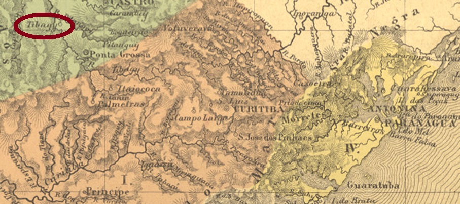
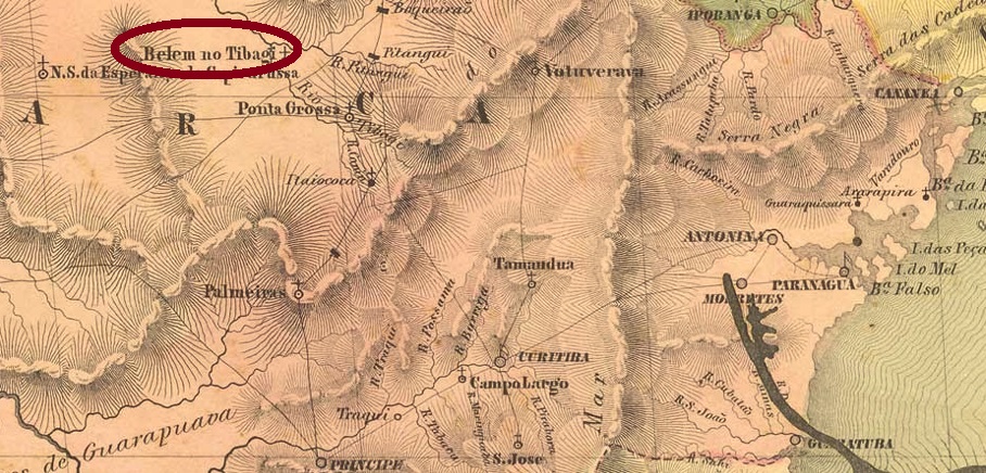
Tibagy was a freguesia of Castro from March 1846, at a time when this municipality still belonged to the province of São Paulo. The village was located on the west bank of the river of the same name, 200 km northwest of the future provincial capital Curitiba. The place name has Indian origins and means place of rest. In March 1872 it became a vila, and in December 1897 a town.
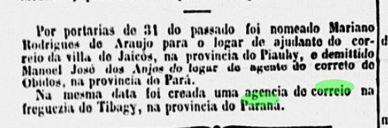
According to Nova Monteiro (Administrações e Agencias Postaes do Brasil Imperio, in Brasil Filatelico/RJ, 1934-5; Reprint SPP 1994-1999), there had been a post office there since October 1864. This is confirmed by the Rio de Janeiro press:
Correio Mercantil/RJ, 04.11.1864
So far, only one imperial postmark of this place has been found, but not the oldest: TPR-0230b (Coll. José A. Junges) is a double circle with the inscription TYBAGI (sic) at the top. This spelling mistake was only corrected in the following cancel from the 20th century. The dates in the middle so far go from 1880 to 1900.
Villiers de l’Ile Adam: Carta (…) da Provincia de São Paulo, 1847
Tibagy war ab März 1846 eine Freguesia bei Castro, zu einer Zeit, als diese Gemeinde noch zur Provinz São Paulo gehörte. Die Ortschaft lag am Westufer des gleichnamigen Flusses, 200 km nordwestlich der künftigen Provinzhauptstadt Curitiba entfernt. Der Ortsname hat indianischen Ursprung und bedeutet Ort des Ausruhens. Im März 1872 wurde daraus eine Vila, und im Dezember 1897 eine Stadt.
Laut Nova Monteiro (Administrações e Agencias Postaes do Brasil Imperio, in Brasil Filatelico/RJ, 1934-5; Reprint SPP 1994-1999) gab es dort ein Postamt seit Oktober 1864. Dies wird durch die Presse aus Rio de Janeiro bestätigt:
Correio Mercantil/RJ, 04.11.1864
Bisher wurde nur ein kaiserlicher Poststempel dieses Ortes gefunden, nicht aber der älteste: TPR-0230b (Samml. José A. Junges) ist ein Doppelkreis mit der Inschrift TYBAGI (sic) oben. Dieser Schreibfehler wurde erst im Folgestempel im 20. Jahrhundert korrigiert. Die Daten in der Mitte gehen bisher von 1880 bis 1900.
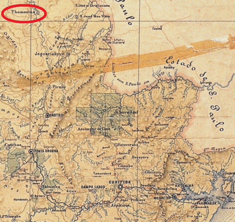
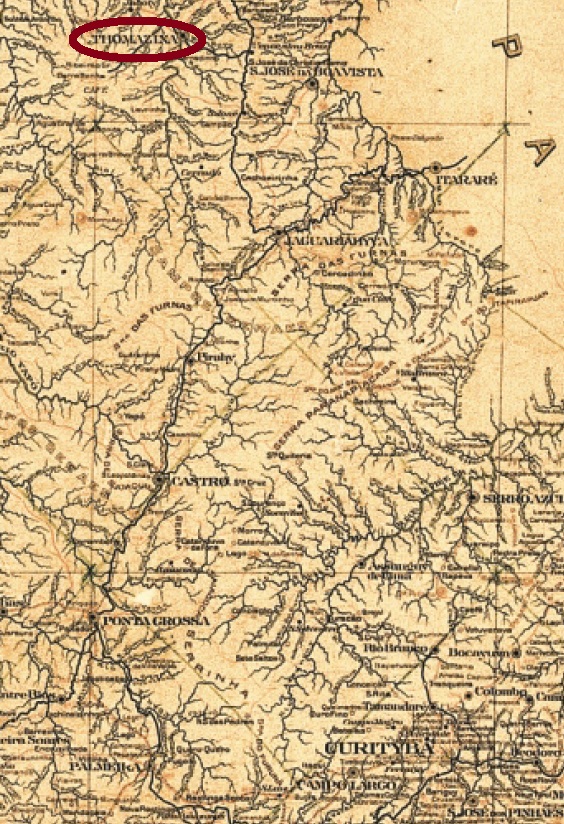
Rio das Cinzas, eventually also called Rio da Cinza (= Ash River), was made a district of the municipality of São José da Boa Vista, the former S. José da Christandade, in April 1879. According to the Brazilian Institute of Geography and Statistics (IBGE), the founder was a major from Minas Gerais, called Joaquim Thomaz Pereira da Silva, who in 1865 bought a big land extension around the Rio das Cinzas, an affluent to the Paranapanema River, some 300 km northwest of Curitiba. Two years later, he started the settlements, and when the locality ascended to a freguesia in 1882, it acquired officially his name. Since May 1889 it is the municipality of Tomazina in Paraná.
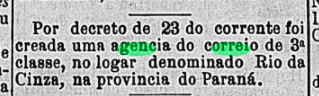
The Imperial Mail Register (Tabella das Agencias do Correio do Império) of 1885 lists a post office in Rio das Cinzas in the Parana province, which was created in 1882. This is corroborated by the press in Rio:
Gazeta da Tarde/RJ, June 26, 1882
So far, no post cancel appeared under the first toponym. With dates from 1886 to 1896, there is TPR-0225a (Coll. José A. Junges): a double circle with the inscriptions THOMAZINA above and PARANA below.
Estado do Paraná, 1922
Siehe auch Rio das Cinzas (RPR-0173)
Rio das Cinzas – gelegentlich auch Rio da Cinza (= Fluss der Asche) – genannt, wurde im April 1879 als Distrikt im Verwaltungsgebiet von São José da Boa Vista (früher São José da Christandade) gegründet. Laut der brasilianischen Behörde für Geografie und Statistik (IBGE) hieß der Gründer Joaquim Thomaz Pereira da Silva, ein Major aus Minas Gerais, der in 1865 große Ländereien um den Rio das Cinzas – einen Nebenfluss des Paranapanema – etwa 300 km nordwestlich von Curitiba erwarb. Zwei Jahre später startete die Besiedlung, und als der Ort in 1882 zu einer Freguesia aufstieg, erhielt er offiziell den Namen des Gründers. Seit Mai 1889 ist es der Municipio von Tomazina in Paraná.
Das Verzeichnis der kaiserlichen Postämter (Tabella das Agencias do Correio do Império) von 1885 listet ein im Jahr 1882 gegründetes Postamt in Rio das Cinzas in der Provinz Paraná auf. Dies kann durch die Rio Presse bestätigt werden:
Gazeta da Tarde/RJ, 26. Juni 1882
Bisher ist kein Poststempel unter dem ersten Ortsnamen aufgetaucht. Mit Daten von 1886 bis 1896 gibt es TPR-0225a (Samml. José A. Junges): ein Doppelkreis mit den Inschriften THOMAZINA oben und PARANA unten.