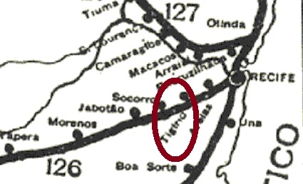
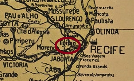
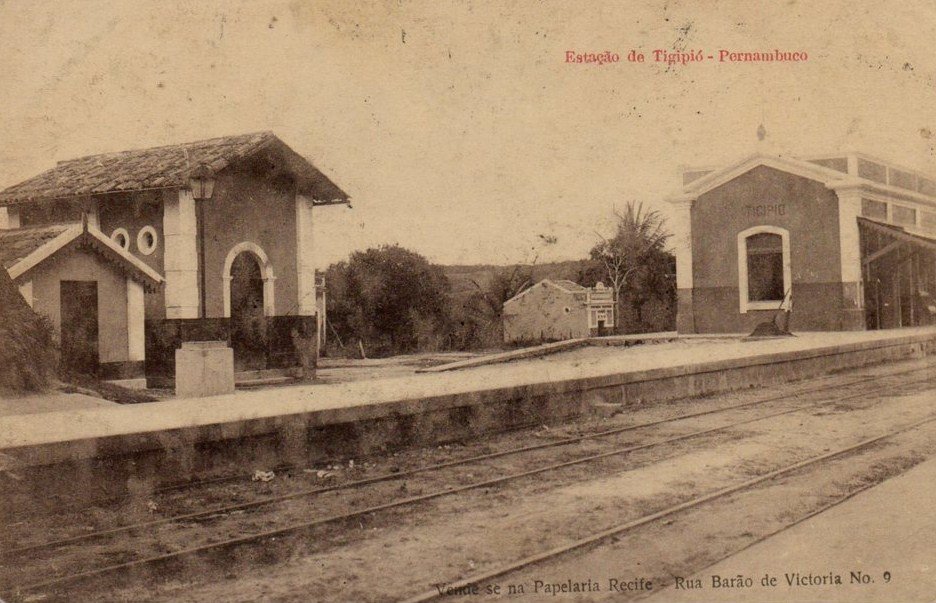
This station (now spelled Tejipió) was inaugurated in March 1885 by the E.F. Central de Pernambuco Railway Company, Central Line, in the município of Recife, and was located about 10 km west of the capital centre. The line belonged to the Great Western railway company from 1904, to Rede Ferroviária do Nordeste from 1950, and to Rede Ferroviária Federal S.A. from 1975 until its closure in 1996 (estacoesferroviarias.com.br).
ca. 1919 (estacoesferroviarias.com.br)
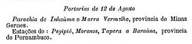
The station post office was established in August 1889 – three months before the republican coup – as shown in the postal report for the following month:
Boletim Postal No.5, Nov/89
Until now, no imperial postmark from this station could be found.
Arthur D. Ribeiro: Estado de Pernambuco, 1924
Dieser Bahnhof (nun Tejipió geschrieben) wurde im März 1885 durch die E.F. Central de Pernambuco Bahngesellschaft, Zentraler Linie, im Município von Recife eingeweiht und lag ca. 10 km westlich der Hauptstadtmitte. Die Linie gehörte ab 1904 der Great Western Bahngesellschaft, ab 1950 der Rede Ferroviária do Nordeste, und von 1975 bis zur Stilllegung 1996 der Rede Ferroviária Federal S.A. (estacoesferroviarias.com.br).
ca. 1919 (estacoesferroviarias.com.br)
Das Bahnhofspostamt entstand im August 1889 – also drei Monate vor dem Republikputsch – wie aus dem Postbericht für den folgenden Monat hervorgeht:
Boletim Postal Nr.5, Nov./89
Bisher war kein kaiserlicher Poststempel von diesem Bahnhof zu finden.
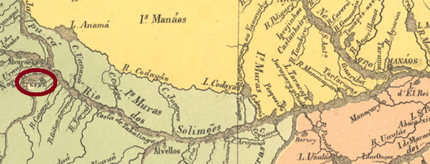
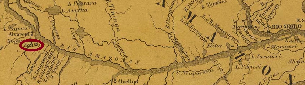
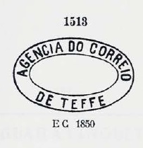
This village was a settlement on the south bank of the Rio Tefé, where it flows into the Amazon. The word comes from the nheegatu Indian language and means deep. In 1759, it became a vila called Egas (or also Ega), and since June 1859, the place has been the town of Teffé.
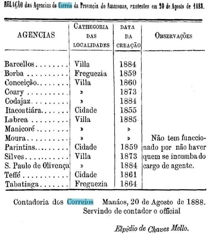
There were three years in which the local post office was founded. Nova Monteiro writes March 1829 for it in Administrações e Agencias Postaes do Brasil Imperio (in Brasil Filatelico/RJ, 1934-5; Reprint SPP 1994-1999). The Directory of Imperial Post Offices (Tabella das Agencias do Correio do Imperio, Rio de Janeiro, 1885) lists the postal agency from 1851. And in a list published in the Provincial President’s Report in August 1888, the Teffé post office is listed as created in 1861:
Relatório do Presidente da Província/AM, August 1888
Also, three different postmarks were found for the 19th century. TAM-0100a is likely to have been in use between about 1851 and at least 1866 and was presented by Paulo Ayres in Catálogo de Carimbos Brasil-Império (S. Paulo, 1937, 1942) under No. 1513:
TAM-0100a (P.A. 1513) 1851ff-1866ff
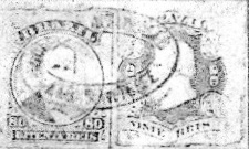
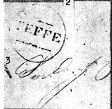
Two postmarks as double circles followed. TAM-0100b (Coll. José A. Junges) has only the inscription TEFFÉ on top. The inner date of the only specimen so far is from 1885. TAM-0100c (image from the internet) could already be republican, as the date inside is from 1891. Here one can also find the indication (AMAZONAS) at the bottom.
In Carimbologia XVII, R. Koester has shown two further imperial postmarks from Teffé, although he was not sure about the postal use of the first one:
TAM-0100d (RK)TAM-0100e (RK) 1876ffVilliers de l’Ile Adam: Carta (…) das Provincias do Grão Pará e Alto Amazonas, 1850
Textaktualisierung am 28. Mai 2024
Andere Namen: Ega, Egas
Diese Ortschaft war eine Siedlung am Südufer des Rio Tefé, wo dieser in den Amazonas mündet. Das Wort kommt aus der Nheegatu-Indianersprache und bedeutet tief. 1759 wurde daraus eine Vila, die Egas (oder auch Ega) hieß, und seit Juni 1859 ist der Ort die Stadt Teffé.
Drei Gründungsjahre fürs örtliche Postamt waren zu finden. Nova Monteiro schreibt dafür in Administrações e Agencias Postaes do Brasil Imperio (in Brasil Filatelico/RJ, 1934-5; Reprint SPP 1994-1999) den März 1829. DasVerzeichnis der kaiserlichen Postämter (Tabella das Agencias do Correio do Imperio, Rio de Janeiro, 1885) listet die Postagentur ab 1851 auf. Und in einer Liste, die im Bericht des Provinzpräsidenten im August 1888 veröffentlicht wurde, wird das Postamt Teffé mit Gründungsjahr 1861 geführt:
Relatorio do Presidente da Provincia/AM, August 1888
Ebenfalls drei verschiedene Poststempel wurden für den 19. Jahrhundert gefunden. TAM-0100a war nachweislich zwischen ca. 1851 und mindestens 1866 in Gebrauch und wurde durch Paulo Ayres in Catálogo de Carimbos Brasil-Império (S. Paulo, 1937, 1942) unter Nr. 1513 vorgestellt:
TAM-0100a (P.A. 1513) 1851ff-1866ff
Es folgten zwei Poststempel als Doppelkreise. TAM-0100b (Samml. José A. Junges) hat nur die Inschrift TEFFÉ oben. Das innere Datum des bisher einzigen Exemplars stammt aus dem Jahr 1885. TAM-0100c (Abb. aus dem Internet) könnte bereits republikanisch sein, da das Datum innen aus 1891 ist. Hier findet man zusätzlich die Angabe (AMAZONAS) unten.
R. Koester hat in Carimbologia XVII zwei weitere kaiserliche Poststempel aus Teffé gezeigt, wobei er sich bei dem ersten über die postalische Verwendung nicht sicher war:
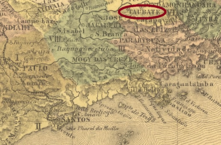
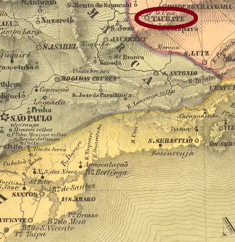
This old village was the freguesia of São Francisco das Chagas de Taubaté, appointed by royal decree (Provisão Real) in December 1645, located on the south bank of the river Parahyba do Sul, 130 km northeast of the future provincial capital of São Paulo. Allegedly, the ascent to the vila also took place in December 1645, which would be rather unusual. Taubaté has been a town since February 1842. The Indian name means village on the hill.
As Nova Monteiro writes in Administrações e Agencias Postaes do Brasil Imperio (in Brasil Filatelico/RJ, 1934-5; Reprint SPP 1994-1999), there was a post office there since May 1828. The pre-philatelic postmark from there is TSP-1420a, it was in use until about 1841 and was already presented in the RHM catalogue under P-SP-57. However, there are small discrepancies between the catalogue illustration and the actual postmark specimens:
TSP-1420a (RHM P-SP-57- recte), 1828-1841
Then came the seal-like TSP-1420b, presented by Paulo Ayres in Catálogo de Carimbos Brasil-Império (S. Paulo, 1937, 1942) under no. 30/1942 and used between 1842 and at least 1844:
TSP-1420b (P.A. 1942/30) 1842-1844ff
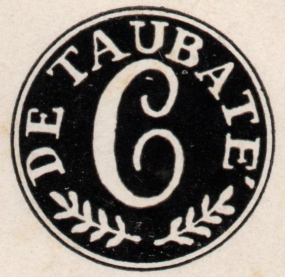
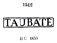
The following five place stamps were also seen in Paulo Ayres (op. cit.). TSP-1420c is P.A. 1512, it also exists in red, and was in use from about 1850 to at least 1876.
TSP-1420c (P.A. 1512), 1850ff-1876ff
For TSP-1420d there are also small differences between the P. Ayres illustration no.1551 and the examples found:
TSP-1420d (P.A. 1551-recte) 1866-1867ff
The French-type TSP-1420e is found on P. Ayres on p. 118 and also exists in red:
TSP-1420e (P.A. p. 118) 1877-1890
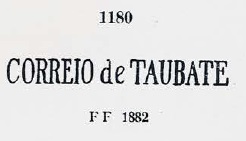
Around the same period, TSP-1420f was used, also in lilac, no. 1180 on P. Ayres:
TSP-1420f (P.A. 1180) 1866ff-1882ff
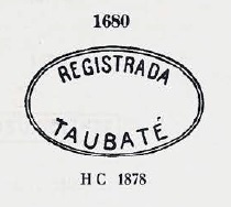
TSP-1420g (P.Ayres 1680) was used for registered mail:
TSP-1420g (P.A. 1680) 1878ff
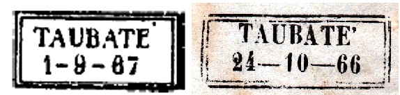
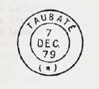
Then TSP-1420h (Coll. José A. Junges) was in use between 1880 and 1895: a plain double circle with the inscription TAUBATÉ on top.
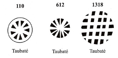
Three mute cancellations from Taubaté are shown in Mute Cancellations of the Brazil Empire/ Carimbos Mudos do Brasil Império (Brazil Philatelic Association, Rio de Janeiro, 2000) by J.A. Dingler and K.W. Lopes under nos. 110, 612 and 1318:
BPA 110, 612, 1318
Two other mute cancels come from the José A. Junges collection, both on D. Pedro issues from 1866:
(JJ) 18661866ff (JJ) with TSP-1420cVilliers de l’Ile Adam: Carta (…) da Provincia de São Paulo, 1847
Diese alte Ortschaft war im Dezember 1645 die durch königliche Verfügung (Provisão Real) ernannte Freguesia von São Francisco das Chagas de Taubaté, die am Südufer des Flusses Parahyba do Sul lag, 130 km nordöstlich der künftigen Provinzhauptstadt São Paulo entfernt. Angeblich soll auch im Dezember 1645 der Aufstieg zur Vila stattgefunden haben, was eher ungewöhnlich wäre. Seit Februar 1842 ist Taubaté eine Stadt. Der indianische Name bedeutet Dorf auf der Anhöhe.
Wie Nova Monteiro in Administrações e Agencias Postaes do Brasil Imperio (in Brasil Filatelico/RJ, 1934-5; Reprint SPP 1994-1999) schreibt, gab es dort ein Postamt seit Mai 1828. Der Prephila-Poststempel von dort ist TSP-1420a, er war bis ca. 1841 in Gebrauch und wurde bereits im RHM-Katalog unter P-SP-57 vorgestellt. Allerdings gibt es kleine Abweichungen zwischen der Katalog-Abbildung und den tatsächlichen Stempelexemplaren:
Die folgenden fünf Ortsstempel waren auch in Paulo Ayres (op. cit.) zu sehen. TSP-1420c ist P.A. 1512. Ihn gibt es auch in Rot, und er war zwischen ca. 1850 bis mindestens 1876 in Gebrauch.
TSP-1420c (P.A. 1512) 1850ff-1876ff
Bei TSP-1420d gibt es ebenfalls kleine Unterschiede zwischen der P. Ayres Abbildung Nr.1551 und den gefundenen Beispielen:
TSP-1420d (P.A. 1551-recte) 1866-1867ff
Der französischer Typus TSP-1420e steht auf P. Ayres auf S. 118 und kommt auch in Rot vor:
TSP-1420e (P.A. S. 118) 1877-1890
Etwa im gleichen Zeitraum wurde TSP-1420f – auch in lila – verwendet, die Nr. 1180 bei P. Ayres:
TSP-1420f (P.A. 1180) 1866ff-1882ff
TSP-1420g (P.Ayres 1680) war für Einschreibsendungen bestimmt:
TSP-1420g (P.A. 1680) 1878ff
Dann war noch TSP-1420h (Samml. José A. Junges) zwischen 1880 und 1895 in Gebrauch: ein schlichter Doppelkreis mit der Inschrift TAUBATÉ oben.
Drei stumme Entwertungen aus Taubaté sind in Mute Cancellations of the Brazil Empire/ Carimbos Mudos do Brasil Império, (Brazil Philatelic Association, Rio de Janeiro, 2000) von J.A. Dingler und K.W. Lopes unter den Nr. 110, 612 und 1318 aufgelistet:
BPA 110, 612, 1318
Zwei weitere stumme Stempel kommen aus der Sammlung José A. Junges, beide auf D. Pedro-Briefmarken aus 1866:
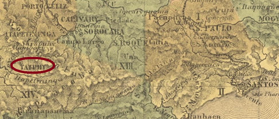
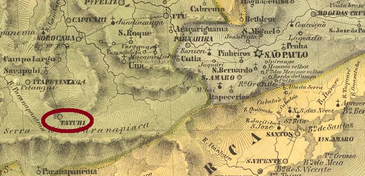
Tatuhy (also Tatuhi, now spelled Tatuí) was a freguesia of the Vila of Itapetininga from March 1822, located on the north bank of the Tatuí River (a tributary of the Sorocaba), 140 km west of the later provincial capital of São Paulo. It was elevated to the status of a vila in February 1844 and became a town in July 1861. The place name comes from the Tupi-guarani language and means river of armadillos.
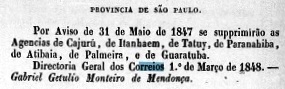
The local post office opened at least twice, although it has not yet been possible to date the first opening precisely. It is likely to have taken place around 1844. However, the agency closed in May 1847, according to an imperial ministerial report:
Relatório do Ministério do Império, 1848
The second opening, however, took place immediately in April of the following year, as Nova Monteiro writes in Administrações e Agencias Postaes do Brasil Imperio (in Brasil Filatelico/RJ, 1934-5; reprint SPP 1994-1999). The first local cancel TSP-1415a also occurs in light brown and was shown in the RHM catalogue:
TSP-1415a (RHM) ca. 1844
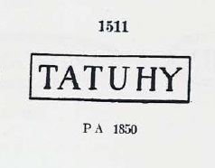
The next two postmarks have already been presented by Paulo Ayres in Catálogo de Carimbos Brasil-Império (S. Paulo, 1937, 1942). TSP-1415b corresponds to P. Ayres No. 1511 and was in use from about 1850 to 1867:
TSP-1415b (P.A. 1511)
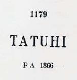
TSP-1415c is No. 1179 by Paulo Ayres, in use from about 1866:
TSP-1415c (P.A. 1179)
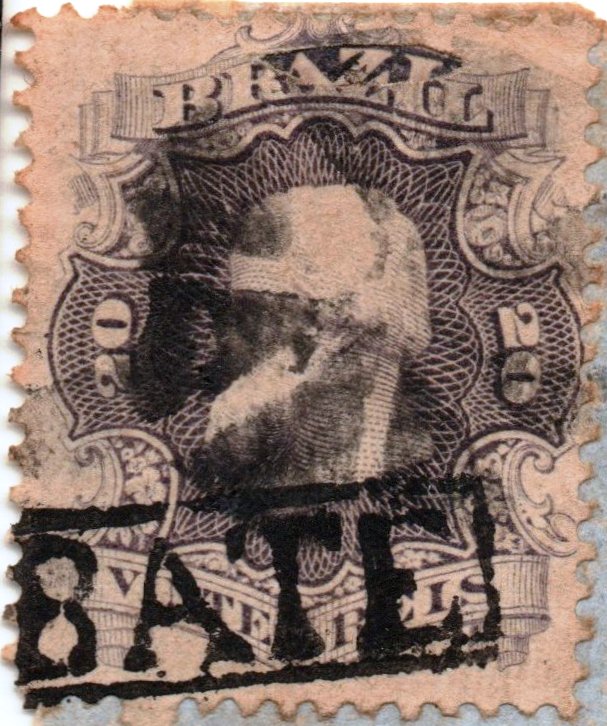
There followed four town stamps in double circle with the above inscription TATUHY. TSP-1415d (Coll. Mário Orsi Jr.) is a French type with the small star between brackets at the bottom, which also occurs in red. The dates inside have been found so far for the period 1776-1883. TSP-1415e (Coll. José A. Junges) is a plain double circle without decoration at the bottom, dated 1878-1880 in the centre. TSP-1415f (Coll. José A. Junges) has dates of 1884 and 1885 in the centre and an ornament at the bottom formed by four branches in lozenge. And TSP-1415g (Coll. José A. Junges) also appears in turquoise and blue and shows inner dates between 1886 and 1896. Here the lower ornament at the bottom is a cross-shaped circle with a smaller white circle in its centre.
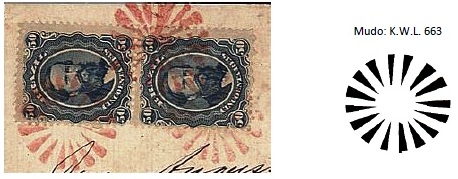
Philatelist Mario Celso Orsi Jr. was able to identify two mute cancels for Tatuhy listed in Mute Cancellations of the Brazil Empire / Carimbos Mudos do Brasil Império (Brazil Philatelic Association, Rio de Janeiro, 2000) by J.A. Dingler and K.W. Lopes. The cancel BPA 663 was found on a letter from 1876:
BPA 663 (MO) 1876
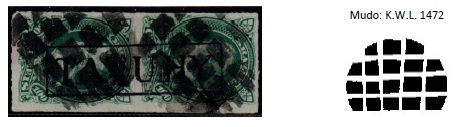
And cancel BPA 1472 was seen on a D. Pedro issue from 1877:
BPA 1472 (MO) 1877ffVilliers de l’Ile Adam: Carta (…) da Provincia de São Paulo, 1847
Tatuhy (auch Tatuhi, heute Tatuí geschrieben) war ab März 1822 eine Freguesia der Vila von Itapetininga, die am Nordufer des Flusses Tatuí (ein Nebenfluss des Sorocabas) lag, 140 km westlich der späteren Provinzhauptstadt São Paulo entfernt. Im Februar 1844 wurde der Ort zur Vila erhoben und ist seit Juli 1861 eine Stadt. Der Ortsname kommt aus der Tupi-guarani-Sprache und bedeutet Fluss der Gürteltiere.
Das örtliche Postamt eröffnete mindestens zweimal, wobei die erste Entstehung bisher nicht genau datiert werden konnte. Sie dürfte ca. 1844 stattgefunden haben. Die Agentur schloss aber im Mai 1847, wie aus einem kaiserlichen Ministerialbericht hervorgeht:
Relatório do Ministério do Império, 1848
Die zweite Eröffnung erfolgte aber gleich im April des folgenden Jahres, wie Nova Monteiro in Administrações e Agencias Postaes do Brasil Imperio (in Brasil Filatelico/RJ, 1934-5; Reprint SPP 1994-1999) schreibt. Der erste Ortsstempel TSP-1415a kommt auch in hellbraun vor und wurde im RHM-Katalog abgebildet:
TSP-1415a (RHM) ca. 1844
Die nächsten zwei Poststempel sind bereits durch Paulo Ayres in Catálogo de Carimbos Brasil-Império (S. Paulo, 1937, 1942) vorgestellt worden. TSP-1415b entspricht P. Ayres Nr. 1511 und war im Gebrauch von ca. 1850 bis 1867:
TSP-1415b (P.A. 1511)
TSP-1415c ist Nr. 1179 von Paulo Ayres, verwendet ab ca. 1866:
TSP-1415c (P.A. 1179)
Es folgten vier Ortsstempel in Doppelkreis mit der obigen Inschrift TATUHY. TSP-1415d (Samml. Mário Orsi Jr.) ist ein französischer Typus mit dem kleinen Stern zwischen Klammern unten, der auch in Rot vorkommt. Die Daten im Inneren wurden bisher für den Zeitraum 1776-1883 gefunden. TSP-1415e (Samml. José A. Junges) ist ein schlichter Doppelkreis ohne Verzierung unten, datiert 1878-1880 in der Mitte. TSP-1415f (Samml. José A. Junges) hat Daten von 1884 und 1885 in der Mitte und ein Ornament unten, das aus vier Zweigen in Raute gebildet wird. Und TSP-1415g (Samml. José A. Junges) kommt auch in türkis und blau vor und zeigt innere Daten zwischen 1886 und 1896. Hier ist die untere Verzierung unten ein kreuzförmiger Kreis mit einem kleineren weißen Kreis in der Mitte.
Der Philatelist Mario Celso Orsi Jr. konnte zwei stumme Stempel für Tatuhy identifizieren, die in Mute Cancellations of the Brazil Empire / Carimbos Mudos do Brasil Império (Brazil Philatelic Association, Rio de Janeiro, 2000) von J.A. Dingler und K.W. Lopes aufgelistet waren. Der Stempel BPA 663 wurde auf einem Brief aus 1876 gefunden:
BPA 663 (MO), 1876
Und der Stempel BPA 1472 war auf einer D. Pedro Marke aus dem Jahr 1877 zu sehen:
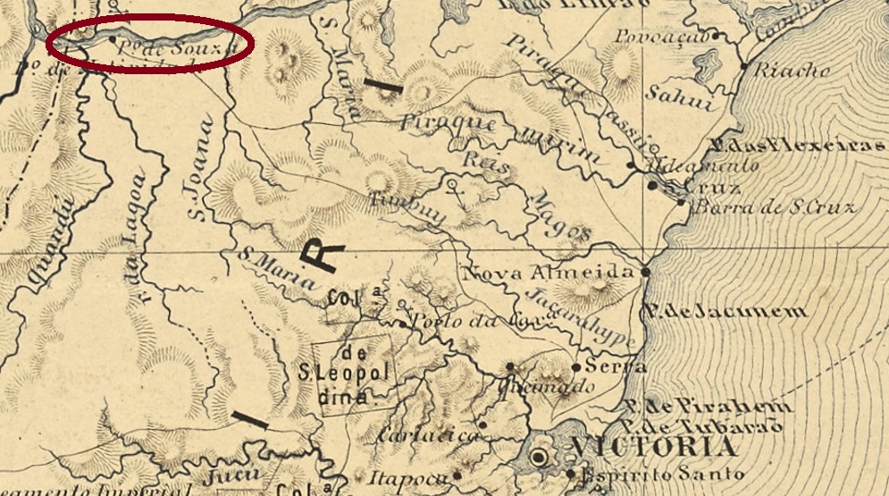
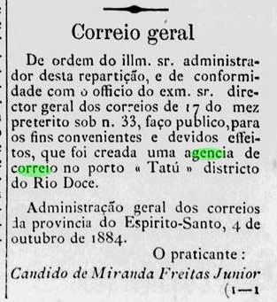
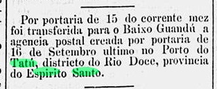
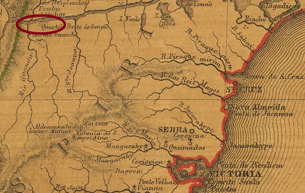
This village was not much more than a small port with a general shop (Empório) on the Rio Doce, located about 180 km from the provincial capital of Vitória. In February 1915, the village was incorporated into the newly created district of Baixo Guandu in the municipality of Linhares. Since April 1935 it has been a rural suburb of the Município of Baixo Guandu.
There was really a post office there, which was in operation for only three months, from September to December 1884:
A Provincia do Espirito Santo, 05.10.1884O Paiz/RJ, 16.12.1884
So far, no postmark of this locality has turned up. Must be a great rarity.
Provincia do Espirito Santo, 1873
Anderer Name: Porto do Tatú
Dieser Ortschaft war eigentlich ein kleiner Flusshafen mit einem Gemischtwarenladen (Empório) am Rio Doce, etwa 180 km der Provinzhauptstadt Vitória gelegen. Im Februar 1915 wurde der Ort dem neu gegründeten Distrikt von Baixo Guandu in der Gemeinde Linhares zugesprochen. Seit April 1935 ist es ein ländlicher Vorort des Município von Baixo Guandu.
Es gab dort tatsächlich ein Postamt, der lediglich drei Monate in Betrieb war, vom September bis Dezember 1884:
A Provincia do Espirito Santo, 05.10.1884O Paiz/RJ, 16.12.1884
Bisher ist kein Poststempel dieser Ortschaft aufgetaucht. Muss eine große Seltenheit sein.
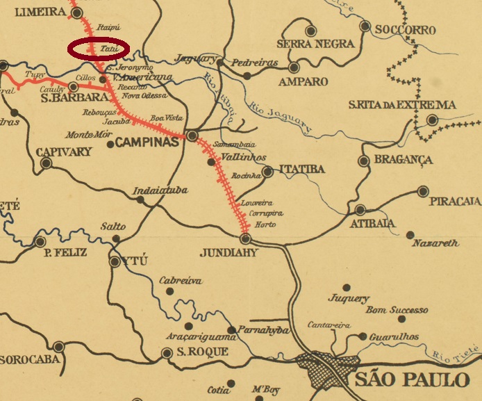
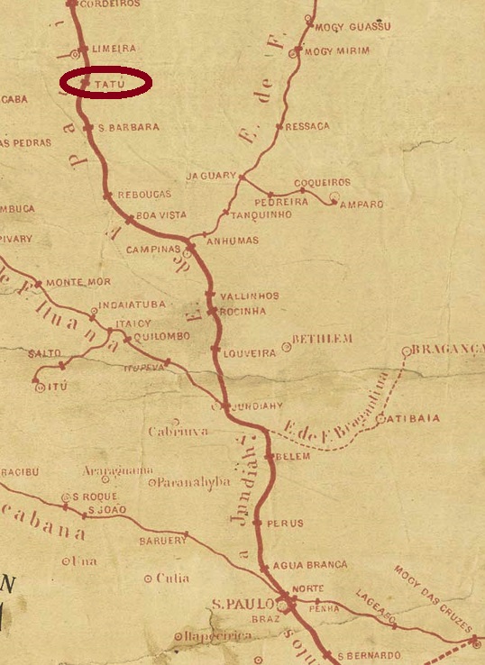
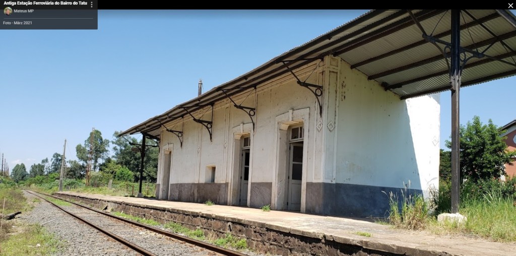
The Tatú (Armadillo) station was inaugurated in June 1876 by the Cia. Paulista Railway Company (main line) in the municipality of Limeira, located 140 km northwest of the provincial capital of São Paulo. The railway line was owned by FEPASA (estacoesferroviarias.com.br) from 1971 until its closure in 1998. A settlement grew up around the station, which was elevated as a district in November 1944, but since December 1953 it has been an outskirt of Limeira.
Photo: Mateus MP (CC-BY-SA)
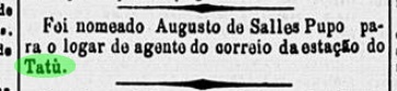
The station post office was created before May 1886, when probably the first postal clerk was nominated, according to the regional press:
Correio Paulistano, 30.05.1886
The imperial postmark is TSP-1410a (Coll. José A. Junges): a double circle with the inscription TATU above and an unfortunately illegible ornament below. The only specimen bears a date from 1887 in the centre.
Estações Ferroviarias do Rio de Janeiro, São Paulo e Minas Geraes, 1880
Der Bahnhof Tatú (Gürteltier) wurde im Juni 1876 durch die Cia. Paulista Eisenbahngesellschaft (Hauptlinie) in der Gemeinde Limeira eingeweiht und lag 140 km nordwestlich der Provinzhauptstadt São Paulo entfernt. Die Bahnlinie ging von 1971 bis zur Stilllegung 1998 in Besitz der FEPASA (estacoesferroviarias.com.br). Um den Bahnhof herum wuchs eine Siedlung, die im November 1944 als Distrikt erhoben wurde, seit Dezember 1953 aber ist sie ein Stadtteil von Limeira.
Foto: Mateus MP (CC-BY-SA)
Das Bahnhofspostamt entstand vor Mai 1886, als ein (erster?) Postangestellter ernannt wurde, wie aus der Regionalpresse hervorgeht:
Correio Paulistano, 30.05.1886
Der kaiserliche Poststempel ist TSP-1410a (Sammlung José A. Junges): ein Doppelkreis mit der Inschrift TATU oben und einem leider unleserlichen Ornament unten. Das einzige Exemplar trägt ein Datum aus 1887 in der Mitte.
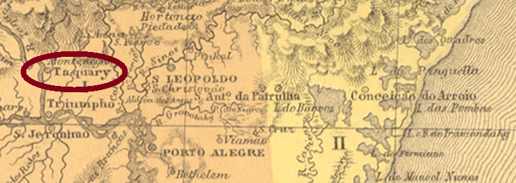
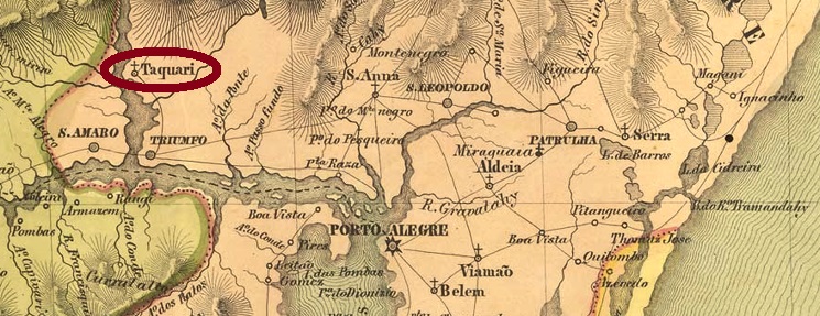
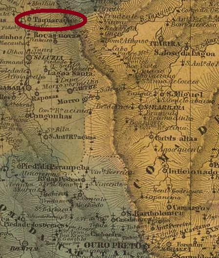
This locality is said to have been called the Chapel of São José do Tibiquary since May 1764, located about 100 km west of the future provincial capital of Porto Alegre. In 1831, it became a freguesia in the município of Triunfo, which was elevated to a vila in July 1849. Taquari has been a town since July 1891.
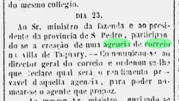
The local post office was established as early as January 1851, as noted by both Nova Monteiro in Administrações e Agencias Postaes do Brasil Imperio (in Brasil Filatelico/RJ, 1934-5; reprint SPP 1994-1999) and Aureo G. Santos in Agências de Correio Criadas e Suprimidas 1851, 1855, 1856 e 1857 (Brasil Filatélico 181, Rio de Janeiro, 1977). This is confirmed by the capital press:
Diario do Rio de Janeiro/01.02.1851
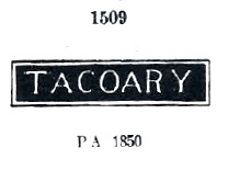
Three local stamps have been found so far for the 19th century. First came TRS-0445a, probably used from the beginning and already seen in Paulo Ayres’ Catálogo de Carimbos Brasil-Império (S. Paulo, 1937, 1942) under No. 1509:
TRS-0445a (P.A. 1509) 1851ff-1877ff
The following postmarks were double circles: TRS-0445b (Coll. José A. Junges) bears only the inscription TAQUARY at the top. The dates in the centre go from 1878 to 1885. TRS-0445c (Coll. José A. Junges) also appears in violet and has the same inscription at the top; there is now an ornament in X at the bottom. The internal dates are from 1890 to 1897.
In 1883, the Margem do Taquary (Taquary shore) station was inaugurated by the E.F. Porto Alegre a Uruguayana railway company. Around 1885, a station post office may also have gone into operation. The station stamp is TRS-0446a: a double ellipse with the inscription E.F. DE PORTO ALEGRE above and A URUGUAYANA below, plus TAQUARY in the centre.
Villiers de l’Ile Adam: Carta (…) da Provincia de São Pedro do Sul, 1847
Diese Ortschaft soll seit Mai 1764 die Kapelle von São José do Tibiquary geheißen haben, da ca. 100 km westlich der künftigen Provinzhauptstadt Posto Alegre entfernt lag. 1831 wurde daraus eine Freguesia im Município von Triunfo, die im Juli 1849 zur Vila erhoben wurde. Seit Juli 1891 ist Taquari eine Stadt.
Drei Ortsstempel wurden bisher für den 19. Jahrhundert gefunden. Zuerst kam TRS-0445a, der wohl von Beginn an verwendet wurde und bereits im Paulo Ayres‘ Catálogo de Carimbos Brasil-Império, (S. Paulo, 1937, 1942) unter Nr. 1509 zu sehen war:
TRS-0445a (P.A. 1509) 1851ff-1877ff
Die folgenden Poststempel waren Doppelkreise: TRS-0445b (Samml. José A. Junges) trägt lediglich die Inschrift TAQUARY oben. Die Daten in der Mitte gehen von 1878 bis 1885. TRS-0445c (Samml. José A. Junges) erscheint auch in violett und hat oben die gleiche Inschrift; unten ist nun ein Ornament in X zu sehen. Die inneren Daten sind von 1890 bis 1897.
1883 wurde der Bahnhof Margem do Taquary (Taquary-Ufer) durch die E.F. Porto Alegre a Uruguayana Bahngesellschaft eingeweiht. Um 1885 dürfte auch ein Bahnhofspostamt in Betrieb gegangen sein. Der Bahnhofsstempel ist TRS-0446a: eine Doppelellipse mit der Inschrift E.F. DE PORTO ALEGRE oben und A URUGUAYANA unten, dazu TAQUARY in der Mitte.
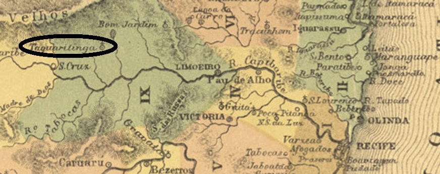
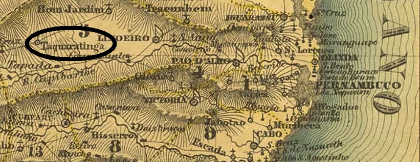
100 years ago, there were two places in Brazil with this name, but the Taquaretinga in São Paulo was not called so until 1907. Our locality in Pernambuco was the freguesia of Santo Amaro de Taquaretinga near Limoeiro from July 1811, located 160 km west of the future provincial capital Recife. In May 1877, it became a vila and 10 years later a town. Since December 1943, the município has been called Taquaritinga do Norte. The name probably comes from itacoaretetinga and means white stone with a large hole the Tupi-guarani language.
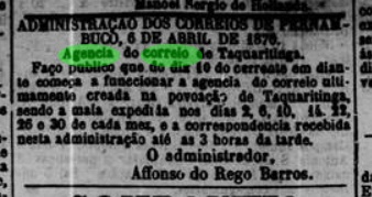
Two years of origin for the local post office have been found. The Directory of Imperial Post Offices (Tabella das Agencias do Correio do Imperio, Rio de Janeiro, 1885) gives the year 1873 for it. If the agency really went into operation, it was short-lived, as this post office was again announced in April 1876:
Diario de Pernambuco, 08.04.1876
Two 19th century postmarks were found. TPE-0625a (Coll. Fuad Ferreira Fo.) is a French type, with the inscription TAQUARETINGA above and the typical star between brackets below. The date on the only specimen so far (a numeral issue from 1885) is missing. TPE-0625b (Coll. José A. Junges) is a double circle with the inscription TAQUARETINGA at the top. The only specimen bears a date from 1898 in the centre.
Villiers de l’Ile Adam: Carta (…) das Provincias de Pernambuco, Alagoas e Sergipe, 1848
Andere Namen: Taquaritinga do Norte (1943)
Vor 100 Jahren gab es zwar in Brasilien zwei Ortschaften, die so hießen, aber die Taquaretinga in São Paulo hat diese Bezeichnung erst 1907 bekommen. Unsere Taquaretinga in Pernambuco war ab Juli 1811 die Freguesia von Santo Amaro de Taquaretinga bei Limoeiro und lag 160 km westlich von der künftigen Provinzhauptstadt Recife entfernt. Im Mai 1877 wurde daraus eine Vila und 10 Jahre später eine Stadt. Seit Dezember 1943 heißt der Município Taquaritinga do Norte. Der Name kommt wohl aus dem Begriff Itacoaretetinga, der Tupi-guarani-Sprache, und heißt weißer Stein mit einem großen Loch.
Zwei Entstehungsjahre fürs örtliche Postamt wurden gefunden. Das Verzeichnis der kaiserlichen Postämter (Tabella das Agencias do Correio do Imperio, Rio de Janeiro, 1885) schreibt dafür das Jahr 1873. Falls die Agentur tatsächlich in Betrieb ging, war sie von kurzer Dauer, denn im April 1876 sollte dieses Postamt nochmals entstanden sein:
Diario de Pernambuco, 08.04.1876
Zwei Poststempel aus dem 19. Jahrhundert wurden gefunden. TPE-0625a (Samml. Fuad Ferreira Fo.) ist ein französischer Typus, mit der Inschrift TAQUARETINGA oben und dem typischen Stern zwischen Klammern unten. Das Datum auf dem bisher einzigen Exemplar (eine Ziffer-Ausgabe aus 1885) fehlt. TPE-0625b (Samml. José A. Junges) ist ein Doppelkreis mit der Inschrift TAQUARETINGA oben. Das einzige Exemplar trägt ein Datum aus 1898 in der Mitte.
Other names: Taquarussu, Taquaraçu de Minas (1962)
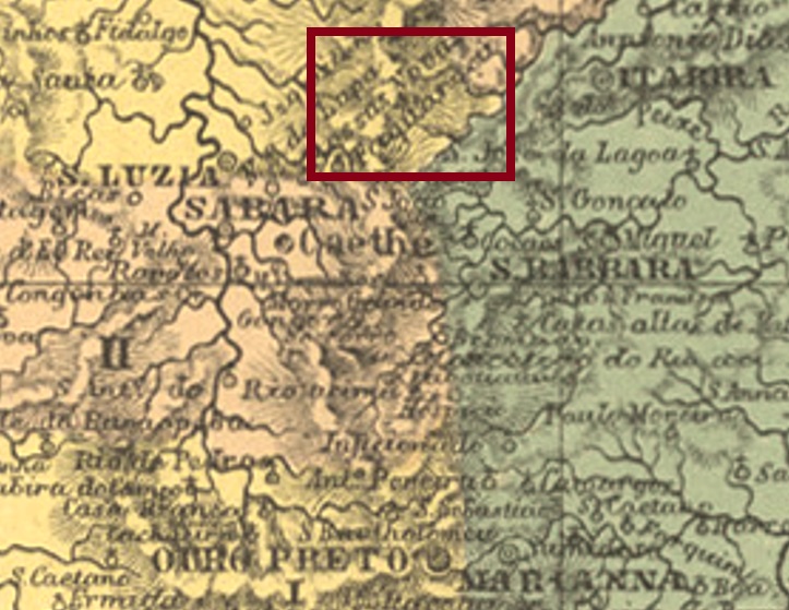
The Freguesia of Santíssimo Sacramento de Taquarassu was established in April 1841 in the Município of Caetés and was located on the south bank of the Rio Taquaraçu, 150 north of the provincial capital Ouro Preto. It was not until December 1962 that the locality gained administrative autonomy, when it became the Município of Taquaraçu de Minas.
Two periods of operation were found for the local post office. First, from about 1845 to March 1847, as can be read in the Annuario for 1846 and in the Rio press:
Annuario 1846Gazeta Official/RJ, 30.03.1847
The second opening of the postal agency took place 35 years later, in August 1882, as Paula Sobrinho writes in História Postal de Minas Gerais (Belo Horizonte, 1997). From the second period of operation, the only postmark of this locality has survived. TMG-3175b (Coll. José A. Junges) is a double circle with the inscription TAQUARASSÚ above and an ornament in lozenge below, the four sides of which are open. The dates inside go from about 1882 to 1890.
Villiers de l’Ile Adam: Carta (…) da Provincia de Minas Geraes, 1849
Andere Namen: Taquarussu, Taquaraçu de Minas (1962)
Die Freguesia von Santíssimo Sacramento de Taquarassu wurde im April 1841 im Município von Caetés errichtet und lag and Südufer des Rio Taquaraçu, 150 nördlich der Provinzhauptstadt Ouro Preto entfernt. Erst im Dezember 1962 kam die Verwaltungsautonomie der Gemeinde zustande, als der Município von Taquaraçu de Minas.
Zwei Betriebsperioden wurden fürs örtliche Postamt gefunden. Erstens von ca. 1845 bis März 1847. Wie im Jahrbuch (Annuario) für 1846 bzw in der Presse aus Rio zu lesen ist:
Annuario 1846Gazeta Official/RJ, 30.03.1847
Die Zweiteröffnung der Postagentur erfolgte erst 35 Jahre später, im August 1882, wie Paula Sobrinho in História Postal de Minas Gerais (Belo Horizonte, 1997) schreibt. Aus der zweiten Betriebsperiode ist auch der bisher einzige Poststempel dieser Ortschaft überliefert. TMG-3175b (Samml. José A. Junges) ist ein Doppelkreis mit der Inschrift TAQUARASSÚ oben und einem Ornament in Raute unten, dessen vier Seiten offen sind. Die Daten in Inneren gehen von ca. 1882 bis 1890.
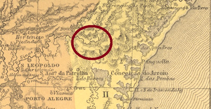
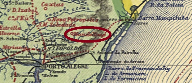
Senhor Bom Jesus da Taquara do Mundo Novo (Kind Lord Jesus of the New World Bamboo) was the name of the district settled mainly by German colonists, established in May 1882 in the Município of Santo Antonio da Patrulha, 80 km northeast of the provincial capital Porto Alegre. It became a vila as early as May 1886, and a city in December 1908.
In the Directory of Imperial Post Offices (Tabella das Agencias do Correio do Imperio, Rio de Janeiro, 1885), we read that there had been a post office there since 1881. The oldest postmark so far is TRS-0440a (Coll. José A. Junges) a double circle with the inscription TAQUARA above and an ornament in cross below formed by four arrowheads. The dates inside go from 1888 to 1907.
Carta da Republica dos Estados Unidos do Brazil, 1892
Anderer Name: Taquara do Mundo Novo
Senhor Bom Jesus da Taquara do Mundo Novo (Gütiger Herr Jesus des Neuen-Welt-Bambus) hieß der überwiegend durch deutsche Kolonisten besiedelte Distrikt, der im Mai 1882 im Município von Santo Antonio da Patrulha gegründet wurde, 80 km nordöstlich der Provinzhauptstadt Porto Alegre entfernt. Bereits im Mai 1886 wurde daraus eine Vila, und im Dezember 1908 eine Stadt.