Categories
Carimbologia T-Z

Taquara, Município Neutro (TMN-0200)

Mappa do Municipio Neutro, ca. 1880

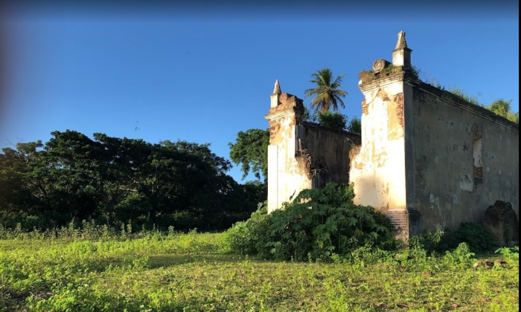
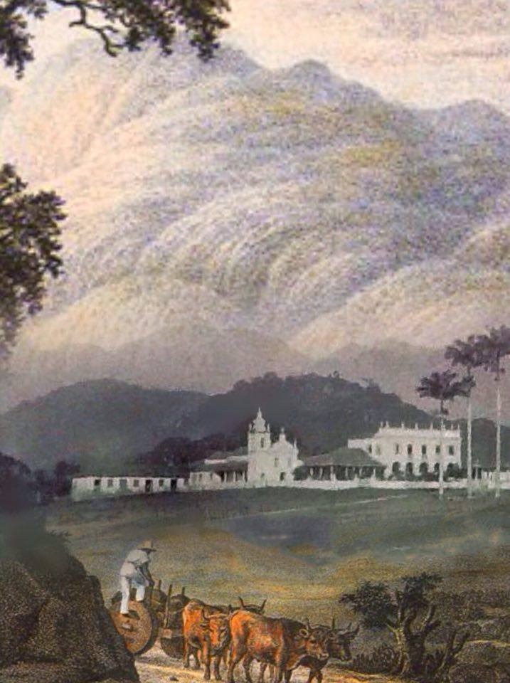
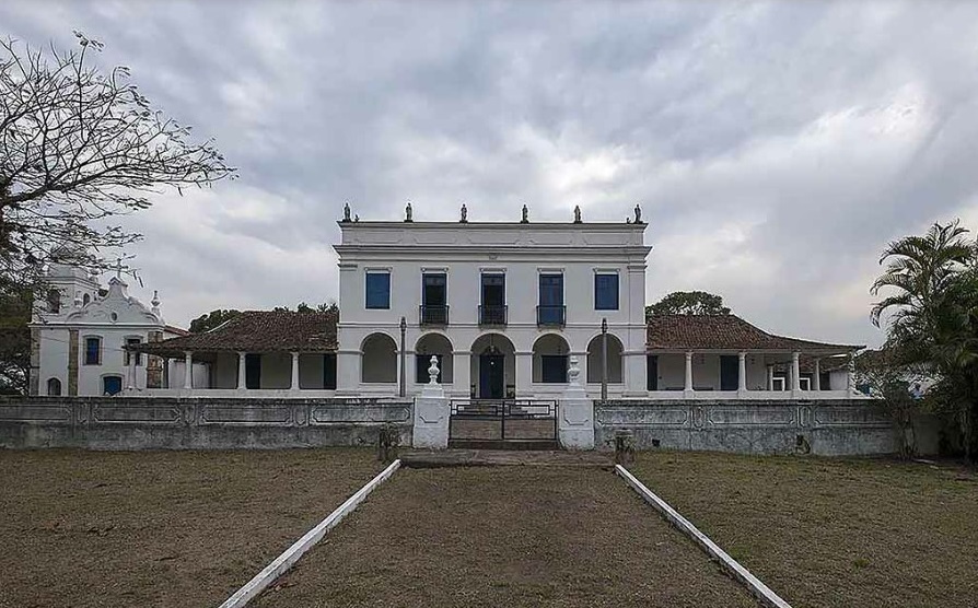
The history of this village began in 1757 with the establishment of the Fazenda da Taquara, 25 km west of the capital Rio de Janeiro. From then on, the estate shaped the social and economic development of the village and produced grapes, among other things, whose wine was allegedly also appreciated by Emperor D. Pedro II.

Instituto Historico e Geografico Itaborahyense

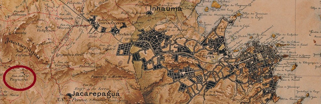
The growing settlement was subordinated to the Freguesia de Jacarepaguá during the 19th century. Today, Taquara is a district of Barra and Jacarepaguá, close to the Pedra Branca (White Stone) Regional Park.

Foto: Oscar H. Liberal (IPHAN)

There are two dates of foundation for the local post office. First in 1872, as listed in the Directory of Imperial Post Offices (Tabella das Agencias do Correio do Imperio, Rio de Janeiro, 1885). Then again in the early Republic, in April 1891, as shown in the postal report (Boletim Postal) of that year. So far, no local postmark from the 19th century has been found.

agenciaspostais.com.br

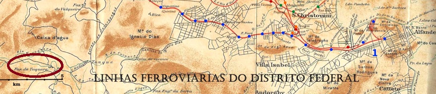
Die Geschichte dieser Ortschaft fing 1757 mit der Errichtung der Fazenda da Taquara an, die 25 km westlich der Hauptstadt Rio de Janeiro entfernt lag. Das Landgut prägte fortan die soziale und wirtschaftliche Entwicklung des Ortes und erzeugte u.a. Trauben, deren Wein angeblich auch vom Kaiser D. Pedro II geschätzt wurde.

Instituto Historico e Geografico Itaborahyense

Die wachsende Siedlung wurde im Lauf des 19. Jahrhunderts der Freguesia de Jacarepaguá untergeordnet. Heute ist Taquara ein Stadtteil des Distrikts von Barra und Jacarepaguá, der nah am Regionalpark der Pedra Branca (Weißer Stein) liegt.

Foto: Oscar H. Liberal (IPHAN)

Zwei Gründungsdaten fürs örtliche Postamt liegen vor. Erstmals 1872, wie im Verzeichnis der kaiserlichen Postämter (Tabella das Agencias do Correio do Imperio, Rio de Janeiro, 1885) aufgelistet. Dann wieder in der frühen Republik, im April 1891, wie aus dem Postbericht (Boletim Postal) des Jahres hervorgeht. Bisher wurde kein lokaler Poststempel aus dem 19. Jahrhundert gefunden.

Categories
Carimbologia T-Z

Tapirussu (TMG-3170), Tapirussu (train station/Bahnhof), Minas Gerais (TMG-3171)

Estado de Minas Geraes, 1910

Tapirussu was a freguesia near São Francisco do Capivara in the Município of Cataguazes from October 1883, a good 270 km southeast of Outo Preto. In March 1891, the village was assigned to the newly created Município of Palmas. Since September 1923, this district has been called Itapiruçu. The word from the tupi-guarani language means big tapir.

The local post office has existed since the beginning of September 1881, as reported by the Rio Press:

Gazeta de Noticias/RJ, 04.09.1881

In April or May 1883, a station of the E.F. Leopoldina Railway Company was inaugurated there, on the so-called Paraoquena branch. From 1975 until its closure in 1996, the railway line belonged to Rede Ferroviária Federal S.A. (estacoesferroviarias.com.br). The station post office was built in 1884. Paula Sobrinho (História Postal de Minas Gerais, Belo Horizonte, 1997) writes 31 March for it. However, it must have taken a while for the post office to start operating, as can be read on the capital’s press:

Jornal do Commercio/RJ, 07.07.1884

It is likely that the opening of the railway post office caused the old local agency to close. Anyway, the move of the post office to the railway station was already requested in January 1884:

Liberal Mineiro, 10.05.1884

This would mean that the old local postmark was also used later in the station agency. The town cancel is TGM-3170a (Coll. José A. Junges): a double circle with the inscription TAPIRUSSÚ above and an ornament in lozenge below. The dates in the centre are from 1885 to 1893. The station postmark is TMG-3171a (Coll. José A. Junges). Here, in addition to the place name at the top, there is the indication (ESTAÇÃO) at the bottom. Dates in the middle from 1886 to 1891.

Estrada de Ferro Leopoldina (mit falschem Namen Tapiaçú)

Tapirussu war ab Oktober 1883 eine Freguesia bei São Francisco do Capivara im Município von Cataguazes, die gut 270 km südöstlich von Outo Preto entfernt lag. Im März 1891 wurde die Ortschaft dem neuentstandenen Município von Palmas zugeordnet. Seit September 1923 heißt dieser Distrikt Itapiruçu. Das Wort aus der Tupi-guarani-Sprache bedeutet großer Tapir.

Das örtliche Postamt gab es seit Anfang September 1881, wie die Rio-Presse berichtet:

Gazeta de Noticias/RJ, 04.09.1881

Im April oder Mai 1883 wurde dort ein Bahnhof der E.F. Leopoldina Eisenbahngesellschaft auf der sogenannten Paraoquena-Abzweigung eingeweiht. Von 1975 bis zur Stilllegung 1996 gehörte die Bahnstrecke der Rede Ferroviária Federal S.A. (estacoesferroviarias.com.br). Das Bahnhofpostamt entstand 1884. Paula Sobrinho (História Postal de Minas Gerais, Belo Horizonte, 1997) schreibt dafür den 31. März. Allerdings dürfte es eine Weile gedauert haben, bis der Postbetrieb aufgenommen wurde, wie aus der Hauptstadtpresse hervorgeht:

Jornal do Commercio/RJ, 07.07.1884

Es ist wahrscheinlich, dass durch die Eröffnung des Bahnpostamts die alte Agentur vor Ort zugemacht hat. Jedenfalls wurde der Umzug des Postamts in den Bahnhof bereits im Januar 1884 beantragt:

Liberal Mineiro, 10.05.1884

Das würde bedeuten, dass der alte Ortsstempel auch später in der Bahnhofsagentur Verwendung fand. Der Ortsstempel ist TGM-3170a (Samml. José A. Junges): ein Doppelkreis mit der Inschrift TAPIRUSSÚ oben und einem Ornament in Raute unten. Die Daten in der Mitte gehen von 1885 bis 1893. Der Bahnhofspoststempel ist TMG-3171a (Samml. José A. Junges): hier gibt es außer dem Ortsnamen oben die Angabe (ESTAÇÃO) unten. Daten in der Mitte von 1886 bis 1891.

Categories
Carimbologia T-Z

Taperoá, Bahia (TBA-0730)

Atlas di Imperio do Brasil, 1868

Another name: Nova Boipeba

This village was originally an Indian settlement called São Miguel de Taperoguá, located between Valença and Cayru, 140 km southwest of the provincial capital Salvador da Bahia. At the beginning of the 19th century, it rose to become a freguesia called Nova Boipeba, but by May 1847 it had become the Vila of Taperoá. Since April 1906, Taperoá has been a town.

As Nova Monteiro writes in Administrações e Agencias Postaes do Brasil Imperio (Brasil Filatelico/RJ, 1934-5; Reprint SPP 1994-1999), there was a post office there since March 1863. Two postmarks have been found, but unfortunately not the very first one. TBA-0730b (Coll. José A. Junges) is a simple double circle with the inscription TAPEROÁ on top. The dates in the centre go from about 1878 to 1893. TBA-0730c (Coll. José A. Junges) should already be Republican. The inscription (BAHIA) now appears at the bottom of the double circle. There is a date from 1899 in the centre.

Villiers de l’Ile Adam: Carta (…) da Provincia da Bahia, 1848

Anderer Name: Nova Boipeba

Diese Ortschaft war ursprünglich ein Indianerdorf namens São Miguel de Taperoguá und lag zwischen Valença und Cayru, 140 km südwestlich der Provinzhauptstadt Salvador da Bahia entfernt. Am Anfang des 19. Jahrhunderts stieg sie zu einer Freguesia namens Nova Boipeba auf, aber schon im Mai 1847 wurde sie zur Vila von Taperoá. Seit April 1906 ist Taperoá eine Stadt.

Wie Nova Monteiro in Administrações e Agencias Postaes do Brasil Imperio (Brasil Filatelico/RJ, 1934-5; Reprint SPP 1994-1999) schreibt, gab es dort ein Postamt seit März 1863. Zwei Poststempel wurden zwar gefunden, leider noch nicht der allererste. TBA-0730b (Samml. José A. Junges) ist ein schlichter Doppelkreis mit der Inschrift TAPEROÁ oben. Die Daten in der Mitte gehen von ca. 1878 bis 1893. TBA-0730c (Samml. José A. Junges) dürfte bereits republikanisch sein. Im Doppelkreis erscheint nun unten die Inschrift (BAHIA) dazu. Datum in der Mitte aus 1899.

Categories
Carimbologia T-Z

Tapera (train station/Bahnhof), Pernambuco (TPE-0620)

Pernambuco Railways 1898 (IBGE)

Tapera station was inaugurated in November 1888 by the E.F. Central de Pernambuco railway company (Central Line) in the Município of Jaboatão and was located about 40 km west of the provincial capital Recife. The line went to Great Western in 1904, to Rede Ferroviária do Nordeste in 1950 and to Rede Ferroviária Federal S.A. in 1975 until its closure in 1996. Since October 1928, the station has been in the Município of Moreno. Today, however, quite little remains of it (estacoesferroviarias.com.br):

Luiz Rubem Bonfim: E.F. Central de Pernambuco, 2002 (estacoesferroviarias.com.br)

Hard to believe, but there was a post office there from August 1889, as shown in the postal report (Boletim Postal) of the following month:

Boletim Postal 5, Sep/89

The station postmark in the 19th century is TPE-0620a (Col. Ginaldo Bezerra da Silva): a double circle with the inscriptions E. DA TAPERA above and (PERNAMBUCO) below. The only specimen seen has a date of 1891 in the centre.

estacoesferroviarias.com.br

Der Bahnhof Tapera wurde im November 1888 durch die E.F. Central de Pernambuco Bahngesellschaft (Zentrumlinie) im Município von Jaboatão eingeweiht und lag ca. 40 km westlich der Provinzhauptstadt Recife entfernt. Die Linie ging 1904 zur Great Western, 1950 zur Rede Ferroviária do Nordeste und 1975 bis zur Stilllegung 1996 zur Rede Ferroviária Federal S.A. Seit Oktober 1928 befindet sich der Bahnhof im Município von Moreno. Heute ist allerdings nicht viel davon übriggeblieben (estacoesferroviarias.com.br):

Luiz Rubem Bonfim: E.F. Central de Pernambuco, 2002 (estacoesferroviarias.com.br)

Kaum zu glauben, aber dort gab es ab August 1889 ein Postamt, wie aus dem Postbericht (Boletim Postal) vom darauffolgenden Monat hervorgeht:

Boletim Postal 5, Sept./89

Der Bahnhofsstempel im 19. Jahrhundert ist TPE-0620a (Col. Ginaldo Bezerra da Silva): ein Doppelkreis mit den Inschriften E. DA TAPERA oben und (PERNAMBUCO) unten. Das einzige gesehene Exemplar trägt in der Mitte die Jahreszahl 1891.

Categories
Carimbologia T-Z

Tapera, Bahia (TBA-0725)

Villiers de l’Ile Adam: Carta (…) da Provincia da Bahia, 1848

Another name: Santa Terezinha (1928)

The Freguesia of Nossa Senhora da Conceição da Tapera was established in April 1843 in the Município of Cachoeira, 200 km west of the provincial capital of Salvador da Bahia. In October 1849, the village rose to the status of vila, but was demoted as a district of Amargosa in April 1877. It was promoted again as a município in May 1890, and since June 1928 the municipality has been called Santa Teresinha.

Two foundation dates for the local post office have been found. First, in September 1866, as stated in the Nova Monteiros Administrações e Agencias Postaes do Brasil Imperio (Brasil Filatelico/RJ, 1934-5; Reprint SPP 1994-1999). Then in 1868, as listed in the Directory of Imperial Post Offices (Tabella das Agencias do Correio do Imperio, Rio de Janeiro, 1885).

Three postmarks exist for the 19th century. First TBA-0725b (Coll. Fuad Ferreira Fo.): a double circle with the inscription TAPERA on top. The dates in the centre go from 1881 to 1889. Then TBA-0725c, as illustrated in Paulo Ayres’ Catálogo de Carimbos Brasil-Império (S. Paulo, 1937, 1942) under no. 1728:

TBA-0725c (P.A. 1728) 1885ff

Most recently TBA-0725d (Coll. José A. Junges). This double circle not only has the inscription TAPERA at the top, but also a five-pointed star as an ornament at the bottom. The inner dates go from 1889 to 1892.

Atlas do Imperio do Brasil, 1868

Andere Name: Santa Terezinha (1928)

Die Freguesia von Nossa Senhora da Conceição da Tapera wurde im April 1843 im Município von Cachoeira errichtet und lag 200 km westlich der Provinzhauptstadt Salvador da Bahia entfernt. Im Oktober 1849 stieg der Ort zur Vila auf, wurde aber im April 1877 als Distrikt von Amargosa degradiert. Der Wiederaufstieg als Município erfolgte im Mai 1890, und seit Juni 1928 heißt die Gemeinde Santa Teresinha.

Zwei Gründungsdaten fürs örtliche Postamt wurden gefunden. Erstens im September 1866, wie im Nova Monteiros Administrações e Agencias Postaes do Brasil Imperio (Brasil Filatelico/RJ, 1934-5; Reprint SPP 1994-1999) zu lesen ist. Dann im Jahr 1868, wie imVerzeichnis der kaiserlichen Postämter (Tabella das Agencias do Correio do Imperio, Rio de Janeiro, 1885) aufgelistet.

Drei Poststempel sind für den 19. Jahrhundert überliefert. Zunächst TBA-0725b (Samml. Fuad Ferreira Fo.): ein Doppelkreis mit der Inschrift TAPERA oben. Die Daten in der Mitte gehen von 1881 bis 1889. Dann TBA-0725c, wie in Paulo Ayres‘ Catálogo de Carimbos Brasil-Império (S. Paulo, 1937, 1942) unter der Nr. 1728 abgebildet:

TBA-0725c (P.A. 1728) 1885ff

Zuletzt TBA-0725d (Samml. José A. Junges). Bei diesem Doppelkreis gibt es nicht nur die Inschrift TAPERA oben, sondern auch einen fünfzackigen Stern als Ornament unten. Die inneren Daten gehen von 1889 bis 1892.

Categories
Carimbologia T-Z

Tanquinho (train station/Bahnhof), São Paulo (TSP-1405)

J.M. Ribeiro Lisboa: Provincia de São Paulo, 1884

Tanquinho station was inaugurated in May 1875 by the Cia. Mogyana railway company (main line) and was located near Campinas, 110 northwest of the provincial capital São Paulo. From 1971 until its closure in 1997, the line belonged to FEPASA (estacoesferroviarias.com.br).

It has not yet been possible to determine when the station post office came into being, but it must have been between 1885 and 1887. For the agency was not listed in the Directory of Imperial Post Offices (Tabella das Agencias do Correio do Imperio, Rio de Janeiro, 1885), but it was included in the Postal Timetable (Horário Postal) for 1887 of the province of São Paulo. The only 19th century postmark so far is TSP-1405a (Coll. José A. Junges): a double circle with the inscription TANQUINHO on top and a black dot as ornament below. The stamp bears no date but was used on a Madrugada issue of 1894.

Estações Ferroviarias do Rio de Janeiro, São Paulo e Minas Geraes, 1880

Der Bahnhof Tanquinho wurde im Mai 1875 durch die Cia. Mogyana Bahngesellschaft (Hauptlinie) eingeweiht und lag bei Campinas, 110 nordwestlich der Provinzhauptstadt São Paulo entfernt. Von 1971 bis zur Stilllegung 1997 gehörte die Linie der FEPASA (estacoesferroviarias.com.br).

Es konnte bisher nicht ermittelt werden, wann das Bahnhofspostamt entstand, aber es muss zwischen 1885 und 1887 stattgefunden haben. Denn die Agentur war nicht im Verzeichnis der kaiserlichen Postämter (Tabella das Agencias do Correio do Imperio, Rio de Janeiro, 1885) aufgelistet, wohl aber im Postfahrplan (Horário Postal) für 1887 der Provinz São Paulo eingetragen. Der bisher einzige Poststempel im 19. Jahrhundert ist TSP-1405a (Samml. José A. Junges): ein Doppelkreis mit der Inschrift TANQUINHO oben und einem schwarzen Punkt als Ornament unten. Der Stempel trägt kein Datum, wurde aber auf eine Madrugada-Ausgabe von 1894 verpasst.

Categories
Carimbologia T-Z

Tanguá (train station/Bahnhof), Rio de Janeiro (TRJ-1905)

Estrada de Ferro Central do Brasil, 1890

Updated on January 11, 2022

Tanguá station was inaugurated in March 1878 by the C.F.C. Niteroiense railway company and was located at Itaborahy, just under 70 km east of the capital Rio de Janeiro. In 1887 the railway line went to the E.F. Leopoldina and from 1975 until its closure in 1996 it belonged to Rede Ferroviária Federal S.A. (estacoesferroviarias.com.br). The settlement around the station continued to grow and became the district of Itaborahy in January 1924. Tanguá has been an independent município since December 1995.

The station post office started its operations in February 1878, according to the Rio press:

Jornal do Commercio/RJ, 07.02.1878

Two station postmarks were found for the 19th century. First came TRJ-1905a, as illustrated in Paulo Ayres’ Catálogo de Carimbos Brasil-Império, (S. Paulo, 1937, 1942) under no. 1510:

TRJ-1905a (P.A. 1510) 1878ff

It was followed by TRJ-1905b (Coll. Fuad Ferreira Fo.): a French type with the inscription TANGUÁ above and the star between brackets below, dated 1883-1886 in the centre. Next came TRJ- 1905c (agenciaspostais.com.br): a double circle with the inscription TANGUÁ above and an ornament in X below. The dates in the middle go from 1893 to 1897.

Almanak Laemmert, 1892

Aktualisiert am 11. Januar 2022

Der Bahnhof Tanguá wurde im März 1878 durch die C.F.C. Niteroiense-Bahngesellschaft eingeweiht und lag bei Itaborahy, knapp 70 km östlich der Hauptstadt Rio de Janeiro entfernt. 1887 ging die Bahnlinie zur E.F. Leopoldina und von 1975 bis zur Stilllegung 1996 gehörte sie der Rede Ferroviária Federal S.A. (estacoesferroviarias.com.br). Die Siedlung um den Bahnhof wuchs weiter und wurde im Januar 1924 zum Distrikt von Itaborahy. Seit Dezember 1995 ist Tanguá ein eigenständiger Município.

Das Bahnhofspostamt startete seinen Betrieb im Februar 1878, wie die Presse aus Rio mitteilte:

Jornal do Commercio/RJ, 07.02.1878

Zwei Bahnhofspoststempel wurden für den 19. Jahrhundert gefunden. Zuerst kam TRJ-1905a, wie im Paulo Ayres‘ Catálogo de Carimbos Brasil-Império, (S. Paulo, 1937, 1942) unter Nr. 1510 abgebildet wurde:

TRJ-1905a (P.A. 1510) 1878ff

Ihm folgte TRJ-1905b (Samml. Fuad Ferreira Fo.): ein Französischer Typus mit der Inschrift TANGUÁ oben und dem Stern zwischen Klammern unten, datiert 1883-1886 in der Mitte. Danach kam TRJ- 1905c (agenciaspostais.com.br): ein Doppelkreis mit der Inschrift TANGUÁ oben und einem Ornament in X unten. Die Daten in der Mitte gehen von 1893 bis 1897.

Categories
Carimbologia T-Z

Tamboril, Ceará (TCE-0335)

Carta da Republica dos Estados Unidos do Brasil, 1892

This locality was a district of the municipality of Ipu from December 1853, located 290 km southwest of the provincial capital Fortaleza. In October 1854, the place rose to become a vila in its own município.

Nova Monteiro writes in Administrações e Agencias Postaes do Brasil Imperio (Brasil Filatelico/RJ, 1934-5; Reprint SPP 1994-1999) that there had been a post office there since August 1866. The oldest postmark so far is TCE-0335b (Coll. José A. Junges): a double circle with the inscription TAMBORIL at the top. The dates in the centre were found for the period 1889-1908.

Atlas do Imperio do Brasil, 1868

Diese Ortschaft war ab Dezember 1853 ein Distrikt der Gemeinde Ipu, der 290 km südwestlich der Provinzhauptstadt Fortaleza lag. Im Oktober 1854 stieg der Ort zu einer Vila im eigenen Município auf.

Nova Monteiro schreibt in Administrações e Agencias Postaes do Brasil Imperio (Brasil Filatelico/RJ, 1934-5; Reprint SPP 1994-1999), dass es dort seit August 1866 ein Postamt gab. Der bisher älteste Poststempel ist TCE-0335b (Samml. José A. Junges): ein Doppelkreis mit der Inschrift TAMBORIL oben. Die Daten in der Mitte wurden für den Zeitraum 1889-1908 gefunden.

Categories
Carimbologia T-Z

Tambahu (train station/Bahnhof), São Paulo (TSP-1400)

Monteiro/Oliveira: Estado de São Paulo, 1927

Inaugurated in October 1887 by the Cia. Mogyana railway company, Tambahu station (now spelled Tambaú) was located on the main line in the Município of Casa Branca, 260 km north of the provincial capital São Paulo. And it remained that way until it was closed in 1959. Around the station, the settlement grew to become a district in 1892, a vila in August 1898, and Tambaú has been a town since December 1906.

Early 20. century (from estacoesferroviarias.com.br)

The station post office was established in March 1888, as one can read in the Rio Press:

Gazeta de Noticias/RJ, 28/03/1888

The 19th century postmark is TSP-1400a (image from the internet): a double circle with the inscriptions EST. TAMBAHU above and S. PAULO below. The only example so far bears a date from 1894 in the centre.

Arthur D. Ribeiro: Estado de São Paulo, 1924

Der Bahnhof Tambahu (heute Tambaú geschrieben) wurde im Oktober 1887 durch die Cia. Mogyana Eisenbahngesellschaft eingeweiht und lag auf der Hauptstrecke im Município von Casa Branca, 260 km nördlich der Provinzhauptstadt São Paulo entfernt. Und so ist es bis zur Stilllegung 1959 geblieben. Rund um den Bahnhof wuchs die Siedlung zum Distrikt 1892, im August 1898 wurde sie eine Vila, und seit Dezember 1906 ist Tambaú eine Stadt.

Am Anfang des 20. Jahrhunderts (aus estacoesferroviarias.com.br)

Das Bahnhofspostamt entstand im Marz 1888, wie man in der Rio Presse lesen kann:

Gazeta de Noticias/RJ, 28.03.1888

Der Poststempel des 19. Jahrhunderts ist TSP-1400a (Abb. aus dem Internet): ein Doppelkreis mit den Inschriften EST. TAMBAHU oben und S. PAULO unten. Das bisher einzige Exemplar trägt ein Datum aus 1894 in der Mitte.

Categories
Carimbologia T-Z

Tamatanduba, Rio Grande do Norte (TRN-0163)

Atlas do Imperio do Brasil, 1868

Tamatanduba is another settlement in 19th century Imperial Brazil that has since disappeared from the map. This settlement was probably a sugar cane fazenda in the freguesia of Villa Flor near Canguaretama, more than 90 km south of the provincial capital of Natal. At the beginning of the republic, the superior district was called Cuitezeiras, then Pedro Velho from November 1908. The Indian word Tamatanduba is said to mean hard-shelled fruit. All that remains of the former village today is the ruined chapel:

Photo: Marcos Vinicius (CC)

We do not know when the local post office was established. It was finally closed in April 1847, as we can read in the report of the Imperial Ministry:

Relatorio do Ministerio do Imperio, April 1847

No postmark has yet been found from this place.

Villiers de l’Ile Adam: Carta (…) das Provincias do Rio Grande do Norte e Parahiba, 1848

Tamatanduba ist eine weitere Ortschaft im kaiserlichen Brasilien des 19. Jahrhunderts, die inzwischen von der Landkarte verschwunden ist. Diese Siedlung war wohl eine Zuckerrohr-Fazenda in der Freguesia von Villa Flor bei Canguaretama, die über 90 km südlich von der Provinzhauptstadt Natal entfernt lag. Am Anfang der Republik hieß der übergeordnete Distrikt Cuitezeiras, seit November 1908 dann Pedro Velho. Das indianische Wort Tamatanduba soll Hartschaliger Obst bedeuten. Aus dem früheren Ort ist heute nur noch die Kapellenruine geblieben:

Foto: Marcos Vinicius (CC)

Wir wissen nicht, wann das örtliche Postamt entstanden ist. Dieses wurde im April 1847 endgültig dichtgemacht, wie man im Bericht des kaiserlichen Ministeriums lesen kann:

Relatorio do Ministerio do Imperio, April 1847

Kein Poststempel wurde bisher aus diesem Ort gefunden.