Categories
Carimbologia T-Z

Tamanduá, Minas Gerais (TMG-3500)

Atlas do Imperio do Brasil, 1868

Update of January 4, 2022

See also Itapecerica (MG), in R. Koester’s Carimbologia XXIV

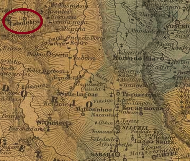
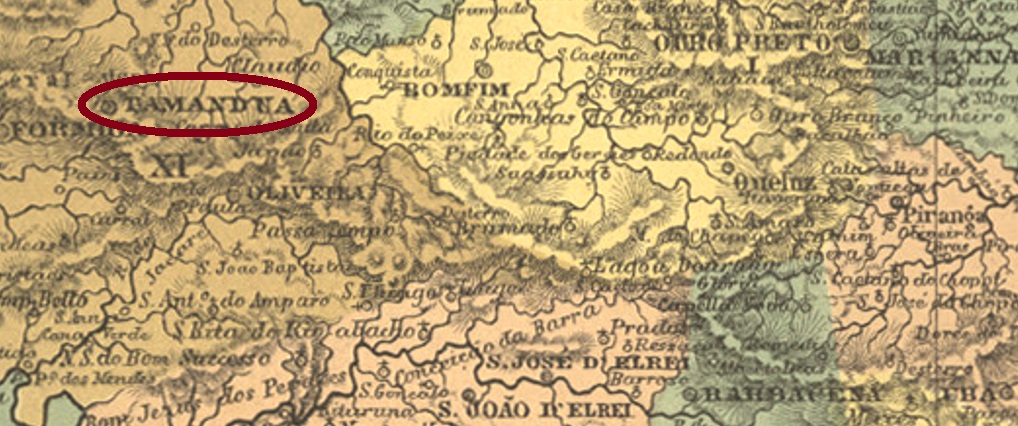
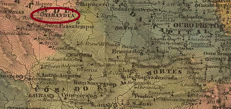
The freguesia of São Bento de Tamanduá (Saint Benedict of the Anteater) was created in 1757 by royal order (Ordem Régia) in the county of S. João d’El-Rey and was located 260 km west of the later provincial capital Ouro Preto. As early as November 1789, it became a vila and in October 1862 a town, which has been called Itapecerica since October 1882. The word from the Indian language means flat stone.

There were no less than three foundation dates for the local post office. First, in May 1809, as Paula Sobrinho writes in História Postal de Minas Gerais (Belo Horizonte, 1997). Then in October 1833, as Nova Monteiro notes in Administrações e Agencias Postaes do Brasil Imperio (Brasil Filatelico/RJ, 1934-5; Reprint SPP 1994-1999). And finally in October 1838, as listed both by Reinhold Koester and in the Directory of Imperial Post Offices (Tabella das Agencias do Correio do Imperio, Rio de Janeiro, 1885).

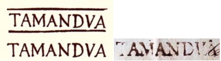
Three 19th century postmarks have been found. TMG-3500a is the pre-philatelic cancellation  recorded with dates between 1827 and at least 1843 and is known through the RHM catalogue (here with and without frame) under P-MG-63. However, the last A seems to be somewhat smaller in reality. This letter would also have an accent above, as shown on the right in the picture (fig. from the internet):

TMG-3500a (RHM P-MG-63 recte) 1839 (EB)

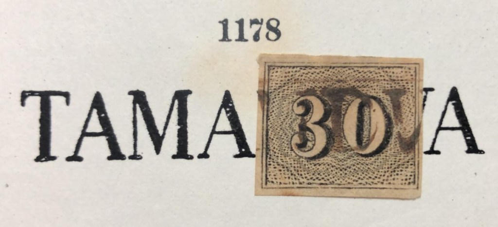
TMG-3500b is very similar to its predecessor, but has slightly narrower letters and no accent over the last A. It also exists in sepia and red, and was presented by Paulo Ayres (Catálogo de Carimbos Brasil-Império, S. Paulo, 1937, 1942) under no. 1178:

TMG-3500b (P.A. 1178) 1850ff-1869

The successor cancel TMG-3500c (Coll. José A. Junges) is a French type with the above inscription TAMANDUÁ and the typical star between brackets at the bottom. Dates in the centre from 1883 to 1896.

Villiers de l’Ile Adam: Carta (…) da Provincia de Minas Gerais, 1849

Siehe auch Itapecerica (MG), in R. Koesters Carimbologia XXIV

Die Freguesia von São Bento de Tamanduá (Heiliger Benedikt des Ameisenbärs) entstand 1757 durch königlichen Befehl (Ordem Régia) in der Gemarkung S. João d’El-Rey und lag 260 km westlich der späteren Provinzhauptstadt Ouro Preto entfernt. Bereits im November 1789 wurde daraus eine Vila und im Oktober 1862 eine Stadt, die seit Oktober 1882 Itapecerica heißt. Das Wort aus der Indianersprache bedeutet flacher Stein.

Nicht weniger als drei Gründungsdaten fürs örtliche Postamt waren zu finden. Erstens im Mai 1809, wie Paula Sobrinho in História Postal de Minas Gerais (Belo Horizonte, 1997) schreibt. Dann im Oktober 1833, wie Nova Monteiro in Administrações e Agencias Postaes do Brasil Imperio ( Brasil Filatelico/RJ, 1934-5; Reprint SPP 1994-1999) vermerkt. Und schließlich im Oktober 1838, wie sowohl durch Reinhold Koester als auch im Verzeichnis der kaiserlichen Postämter (Tabella das Agencias do Correio do Imperio, Rio de Janeiro, 1885) aufgelistet.

Drei Poststempel für den 19. Jahrhundert wurden gefunden. TMG-3500a ist die Vorphila-Abstempelung, die bisher mit Daten zwischen 1827 und mindestens 1843 registriert wurde und durch den RHM-Katalog (hier mit und ohne Rahmen) unter P-MG-63 bekannt ist. Allerdings scheint das letzte A in Wirklichkeit etwas kleiner zu sein. Darauf wäre ein Akzent, wie rechts im Bild (Abb. aus dem Internet) zu sehen:

TMG-3500a (RHM P-MG-63 recte) 1839 (EB)

TMG-3500b ist sehr ähnlich wie sein Vorgänger, hat aber etwas schmalere Buchstaben und keinen Akzent auf dem letzten A. Es gibt ihn auch in sepia und rot, er wurde von Paulo Ayres (Catálogo de Carimbos Brasil-Império, S. Paulo, 1937, 1942) mit Nr. 1178 präsentiert:

TMG-3500b (P.A. 1178) 1850ff-1869

Der Nachfolgestempel TMG-3500c (Samml. José A. Junges) ist ein französischer Typus mit der obigen Inschrift TAMANDUÁ und dem typischen Stern zwischen Klammern unten. Daten in der Mitte von 1883 bis 1896.

Categories
Carimbologia T-Z

Tamandaré, Pernambuco (TPE-0615)

Villiers de l’Ile Adam: Carta (…) das Provincias de Pernambuco, Alagoas e Sergipe, 1848

Tamandaré was a freguesia of the municipality of Rio Formoso, located 100 km south of the provincial capital Recife. It became a district in May 1905 and a município in September 1995. The word from the Tupi-guarani language means anteater of the different kind.

Two creation dates for the local post office were found. A sure indication that it was closed in the meantime. First in May 1858, as Nova Monteiro writes in Administrações e Agencias Postaes do Brasil Imperio (in Brasil Filatelico/RJ, 1934-5; Reprint SPP 1994-1999). Then again in 1873, as shown in the postal report (Relatório Postal) of December 1886. A postmark of the second period of operation was found. TPE-0615b (Coll. José A. Junges) is a plain double circle with the above inscription TAMANDARÉ. All specimens were found on Southern Cross issues from 1890.

Atlas do Imperio do Brasil, 1868

Tamandaré war eine Freguesia der Gemeinde Rio Formoso, die 100 km südlich der Provinzhauptstadt Recife entfernt lag. Im Mai 1905 wurde daraus aus Distrikt und im September 1995 ein Município. Das Wort aus der Tupi-guarani-Sprache bedeutet Ameisenbär der anderen Sorte.

Zwei Gründungdaten fürs örtliche Postamt wurden gefunden. Ein sicheres Indiz dafür, dass es zwischendurch geschlossen wurde. Erstens im Mai 1858, wie Nova Monteiro in Administrações e Agencias Postaes do Brasil Imperio (in Brasil Filatelico/RJ, 1934-5; Reprint SPP 1994-1999) schreibt. Dann wieder 1873, wie aus dem Postbericht (Relatório Postal) von Dezember 1886 hervorgeht. Ein Poststempel der zweiten Betriebsperiode wurde gefunden. TPE-0615b (Samml. José A. Junges) ist ein schlichter Doppelkreis mit der obigen Inschrift TAMANDARÉ. Bisherige Exemplare wurden auf Ausgabe des Kreuzes des Südens aus 1890 gefunden.

Categories
Carimbologia T-Z

Tahy, Rio de Janeiro (TRJ-1605)

agenciaspostais.com.br

Other names: Itahy, Amparo, Pipeiras

The Freguesia of Nossa Senhora do Amparo do Tahy was founded in November 1873 in the municipality of São João da Barra, 300 km northeast of the capital Rio de Janeiro. Around 1933, the district name was changed to Pipeiras, and it has remained that way until today.

As can be read in the Directory of Imperial Post Offices (Tabella das Agencias do Correio do Imperio, Rio de Janeiro, 1885), a post office was built there in 1878 and operated until October 1919 (agenciaspostais.com.br). Also nearby, the E.F. Campos a São Sebastião railway company built a station before the turn of the century, where a post office also operated from about 1898. The imperial postmark of the place is TRG-1605a (image from the Internet): a double circle with the inscription FREG. DE TAHY above and an ornament in circle below, flanked by two semicircles. The dates in the centre go so far from 1889 to 1899.

Google Maps

Andere Namen: Itahy, Amparo, Pipeiras

Die Freguesia von Nossa Senhora do Amparo do Tahy wurde im November 1873 in der Gemeinde São João da Barra gegründet und lag 300 km nordöstlich der Hauptstadt Rio de Janeiro entfernt. Um 1933 wurde der Distriktname zu Pipeiras geändert, und so ist es bis heute geblieben.

Wie im Verzeichnis der  kaiserlichen Postämter (Tabella das Agencias do Correio do Imperio, Rio de Janeiro, 1885) zu lesen ist, wurde dort 1878 ein Postamt errichtet, das bis Oktober 1919 in Betrieb war (agenciaspostais.com.br). Auch in der Nähe baute die E.F. Campos a São Sebastião Bahngesellschaft vor Jahrhundertwende einen Bahnhof, wo ab ca. 1898 auch ein Postamt betrieben wurde. Der kaiserliche Poststempel des Ortes ist TRG-1605a (Abb. aus dem Internet): ein Doppelkreis mit der Inschrift FREG. DE TAHY oben und einem Ornament in Kreis unten, das durch zwei Halbkreisen flankiert wird. Die Daten in der Mitte gehen bisher von 1889 bis 1899.

Categories
Carimbologia T-Z

Tahim, Rio Grande do Sul (TRS-0438)

Atlas do Imperio do Brasil, 1868

Other names: Tahym, Taim

The district of Nossa Senhora da Conceição do Tahim was created in May 1846 and was located on the eastern shore of Lagoa Mirim in the Município of Rio Grande, 360 km south of the provincial capital Porto Alegre. And so, it has remained to this day: an idyllic nature reserve occasionally visited by day tourists.

Photo: Randolfo Santos

The local post office was established in June 1883, according to the Rio Press:

Jornal do Commercio/RJ, 19.06.1883

However, since the agency was not listed in the Directory of Imperial Post Offices (Tabella das Agencias do Correio do Imperio, Rio de Janeiro, 1885), it was probably not in operation immediately or for long. And in August 1886, the regional press reported the resignation of the postal employee, which can be interpreted as an indication of low mail volume in such a remote place:

A Federação, 12.08.1886

No wonder that not a single postmark of the imperial period has been found so far. It must be a rarity.

Villiers de l’Ile Adam: Carta (…) da Provincia de São Pedro do Sul, 1847

Andere Namen: Tahym, Taim

Der Distrikt von Nossa Senhora da Conceição do Tahim wurde im Mai 1846 ins Leben gerufen und lag am Ostufer der Lagoa Mirim im Município von Rio Grande, 360 km südlich der Provinzhauptstadt Porto Alegre entfernt. Und so ist es bis heute geblieben: ein idyllisches Naturschutzgebiet, das gelegentlich von Tagestouristen besucht wird.

Foto: Randolfo Santos

Das örtliche Postamt entstand im Juni 1883, wie aus der Rio-Presse entnommen wird:

Jornal do Commercio/RJ, 19.06.1883

Da die Agentur allerdings nicht im Verzeichnis der kaiserlichen Postämter (Tabella das Agencias do Correio do Imperio, Rio de Janeiro, 1885) aufgelistet wurde, war sie wohl nicht sofort oder lange in Betrieb. Und im August 1886 meldete die Regionalpresse die Kündigung des Postangestellters, was als Hinweis für ein niedriges Postaufkommen in einem so entlegenen Ort gedeutet werden kann:

A Federação, 12.08.1886

Kein Wunder, das bisher kein einziger Poststempel der Kaiserzeit gefunden wurde. Muss eine Seltenheit sein.

Categories
Carimbologia T-Z

Tacoahy, Rio de Janeiro (TRJ-1600)

Almanak Laemmert, 1866

See also Itaguahy (R. Koester: Carimbologia XXIII).

The parish of São Francisco Xavier de Tagoahy (or Tacoahy) was established in December 1795 by royal decree (Ordem Régia) 70 km west of the colonial capital Rio de Janeiro. The word Taguahy comes from the Tupi-Guarani language, means something like waters with yellow mud and names the river in the area that flows into the Sepetiba Bay. In 1818, the place was declared a vila for five months before being reclassified as a district in November of that year. In 1819 it became a vila again, and since June 1892 Itaguaí (as it is now spelled) has been a town in its own municipal charter.

Nova Monteiro (Administrações e Agencias Postaes do Brasil Imperio, in Brasil Filatelico/RJ, 1934-5; Reprint SPP 1994-1999) and Reinhold Koester (Carimbologia XXXIII) agree that there was a post office there from May 1829. The first local postmark is also the only one with this place name so far. TRJ-1600a has already been presentsed by Cicero A. Almeida under No. 380 in Carimbos Postais – século XIX (Rio de Janeiro, 1989):

TRJ-1600a (MPT 380) 1829ff

For other postmarks with Itagoahy or Itaguahy see R. Koester, Carimbologia XXIII.

Villiers de l’Ile Adam: Carta (…) da Provincia do Rio de Janeiro, 1850

Siehe auch Itaguahy (R. Koester: Carimbologia XXIII)

Die Pfarrei São Francisco Xavier de Tagoahy (oder Tacoahy) wurde im Dezember 1795 durch königliche Verfügung (Ordem Régia) 70 km westlich der Kolonialhauptstadt Rio de Janeiro errichtet. Das Wort Taguahy kommt aus der Tupi-Guarani-Sprache, bedeutet etwa Gewässer mit gelbem Schlamm und benennt auch den Fluss der Gegend, der in die Bucht von Sepetiba mündet. 1818 wurde der Ort fünf Monate lang als Vila erklärt, bevor im November des Jahres die Rückstufung als Distrikt erfolgte. 1819 wurde daraus wieder eine Vila, und seit Juni 1892 ist Itaguaí (wie es heute geschrieben wird) eine Stadt im eigenen Gemeindesitz.

Nova Monteiro (Administrações e Agencias Postaes do Brasil Imperio, in Brasil Filatelico/RJ, 1934-5; Reprint SPP 1994-1999) und Reinhold Koester (Carimbologia XXXIII) sind sich darüber einig, dass es dort seit Mai 1829 ein Postamt gab. Der erste lokale Poststempel ist auch bisher der einzige mit dieser Ortsbezeichnung. TRJ-1600a wurde bereits durch Cicero A. Almeida unter Nr. 380 in Carimbos Postais – século XIX (Rio de Janeiro, 1989) vorgestellt:

TRJ-1600a (MPT 380) 1829ff

Für weitere Poststempel mit Itagoahy oder Itaguahy siehe R. Koester, Carimbologia XXIII.

Categories
Carimbologia T-Z

Tacaratu, Pernambuco (TPE-0610)

Atlas do Imperio do Brasil, 1868

Updated on January 11, 2022

Another name: Brejo dos Padres

The freguesia of Brejo dos Padres (Priests’ Swamp), created in 1761, was subordinated to Jatobá in May 1808 and located 440 km southwest of Recife, the provincial capital. In June 1849 it became a vila, but in May 1887 it was downgraded as a district of Jatobá. Finally, Tacaratu became an independent município in September 1928. The word from the Tupi language means mountains with many peaks.

Nova Monteiro writes in Administrações e Agencias Postaes do Brasil Imperio (Brasil Filatelico/RJ, 1934-5; Reprint SPP 1994-1999) that there had been a post office there since April 1858. This is confirmed by the Directory of Imperial Postal Agencies (Tabella das Agencias do Correio do Imperio, Rio de Janeiro, 1885). A postmark has been found for the 19th century, apparently not the very first one. TPE-0610b (Coll. Fuad Ferreira Fo.), which also occurs in purple, is a French type, with the inscription TACARATU at the top and the star between brackets at the bottom. The date in the middle was inscribed by hand, between ca. 1883 and 1889.

Carta Corographica da Provincia de Pernambuco, 1880

Aktualisiert am 11. Januar 2022

Anderer Name: Brejo dos Padres

Die 1761 entstandene Freguesia von Brejo dos Padres (Priestersumpf) wurde im Mai 1808 Jatobá untergeordnet und lag 440 km südwestlich der Provinzhauptstadt Recife entfernt. Im Juni 1849 wurde daraus eine Vila, die aber im Mai 1887 als Distrikt von Jatobá herabgesetzt wurde. Schließlich wurde Tacaratu im September 1928 ein eigenständiger Município. Das Wort aus der Tupi-Sprache bedeutet Gebirge mit vielen Bergspitzen.

Nova Monteiro schreibt in Administrações e Agencias Postaes do Brasil Imperio (Brasil Filatelico/RJ, 1934-5; Reprint SPP 1994-1999), dass es dort seit April 1858 ein Postamt gab. Dieses wird durch das Verzeichnis der kaiserlichen Postagenturen (Tabella das Agencias do Correio do Imperio, Rio de Janeiro, 1885) bestätigt. Ein Poststempel wurde für den 19. Jahrhundert nachgewiesen, offenbar nicht der allererste. TPE-0610b (Samml. Fuad Ferreira Fo.), der auch in lila vorkommt, ist ein Französischer Typus, mit der Inschrift TACARATU oben und dem Stern zwischen Klammern unten. Das Datum in der Mitte wurde mit der Hand eingetragen, zwischen ca. 1883 und 1889.

Categories
Carimbologia T-Z

Taboleiro do Pomba, Minas Gerais (TMG-3160)

Atlas do Imperio do Brasil, 1868

Other names: Senhor Bom Jesus da Cana Verde, Tabuleiro

The word taboleiro (now written tabuleiro) means both plate and (high) plateau in Portuguese. This taboleiro was, from April 1841, a parish called Senhor Bom Jesus da Cana Verde (Our Good Lord Jesus of the Green Sugar Cane), located on the north bank of the Rio Formoso, a tributary of the Rio Pomba, 200 km south of the provincial capital Ouro Preto. In January 1866 it became a district of the municipality of Pomba, and since December 1953 it has been the Município of Tabuleiro.

Both Nova Monteiro (Administrações e Agencias Postaes do Brasil Imperio, in Brasil Filatelico/RJ, 1934-5; Reprint SPP 1994-1999) and Paula Sobrinho (História Postal de Minas Gerais, Belo Horizonte, 1997) agree that there has been a post office there since March 1864. The only postmark of the imperial period so far is probably not the oldest: TMG-3160b (Coll. José A. Junges) is a double circle with the inscription TABOLEIRO DO POMBA above and an ornament in lozenge below, the four sides of which are open. The internal dates were found for the period 1885-1894.

Provincia de Minas Geraes, 1873

Andere Namen: Senhor Bom Jesus da Cana Verde, Tabuleiro

Das Wort Taboleiro (heute tabuleiro geschrieben) bedeutet auf Portugiesisch sowohl Platte als auch (Hoch)plateau. Dieser Taboleiro war ab April 1841 eine Pfarrei namens Senhor Bom Jesus da Cana Verde (Unser Guter Herr Jesus des Grünen Zuckerrohrs), die am Nordufer des Rio Formoso, eines Zuflusses des Rio Pomba, lag, 200 km südlich der Provinzhauptstadt Ouro Preto entfernt. Im Januar 1866 wurde daraus ein Distrikt der Gemeinde Pomba, und seit Dezember 1953 ist es der Município von Tabuleiro.

Sowohl Nova Monteiro (Administrações e Agencias Postaes do Brasil Imperio, in Brasil Filatelico/RJ, 1934-5; Reprint SPP 1994-1999) als auch Paula Sobrinho (História Postal de Minas Gerais, Belo Horizonte, 1997), sind sich darüber einig, dass es dort seit März 1864 ein Postamt gibt. Der bisher einzige Poststempel der Kaiserzeit ist wohl nicht der älteste: TMG-3160b (Samml. José A. Junges) ist ein Doppelkreis mit der Inschrift TABOLEIRO DO POMBA oben und einem Ornament in Raute unten, dessen vier Seiten offen sind. Die inneren Daten wurden für den Zeitraum 1885-1894 gefunden.

Categories
Carimbologia T-Z

Taboleiro Grande, Minas Gerais (TMG-3165)

Atlas do Imperio do Brasil, 1868

Another name: Paraopeba (1911).

This other Taboleiro in the province of Minas Gerais was a district of Sete Lagoas from March 1840, located 190 km northwest of the provincial capital Ouro Preto. And it remained so until November 1911, when it became the Município of Paraopeba.

At least two periods of operation for the local post office have been identified for the 19th century. The first of these was probably at the beginning of the 1940s, when the postmark TMG-3165a was used. This was applied to pre-philatelic objects and was listed in the RHM catalogue under P-MG-62:

TMG-3165a (RHM P-MG-62) ca. 1840-after 02/1847

The agency was closed sometime after February 1847. At that time the post was still occupied, as shown in the Rio press:

Gazeta Official/RJ, 16/02/1847

The second opening of the post office took place in June 1868, as can be read in Nova Monteiro’s Administrações e Agencias Postaes do Brasil Imperio (Brasil Filatelico/RJ, 1934-5; Reprint SPP 1994-1999). From this second period comes SMG-3195c (Coll. José A. Junges): a double circle with the inscriptions TABOLEIRO above and (G) below, which also occurs in red, crimson and violet. The dates in the middle go from 1884 to 1898.

Villiers de l’Ile Adam: Carta (…) da Provincia de MInas Geraes, 1849

Anderer Name: Paraopeba (1911)

Dieser andere Taboleiro in der Provinz Minas Gerais war ab März 1840 ein Distrikt von Sete Lagoas, der 190 km nordwestlich der Provinzhauptstadt Ouro Preto lag. Und so blieb es bis November 1911, als daraus der Município von Paraopeba wurde.

Zumindest zwei Betriebsperioden fürs örtliche Postamt wurden für den 19. Jahrhundert ausfindig gemacht. Die erste davon dürfte am Anfang der 40er Jahre gewesen sein, als der Poststempel TMG-3165a verwendet wurde. Dieser war auf Prephila-Objekten angewendet und wurde im RHM-Katalog unter P-MG-62 aufgelistet:

TMG-3165a (RHM P-MG-62) ca. 1840-nach 02/1847

Die Agentur wurde irgendwann nach Februar 1847 geschlossen. Zu diesem Zeitpunkt war die Stelle noch besetzt, wie aus der Presse aus Rio hervorgeht:

Gazeta Official/RJ, 16.02.1847

Die zweite Eröffnung des Postamts fand im Juni 1868 statt, wie in Nova Monteiros Administrações e Agencias Postaes do Brasil Imperio (Brasil Filatelico/RJ, 1934-5; Reprint SPP 1994-1999) zu lesen ist. Aus dieser zweiten Periode stammt SMG-3195c (Samml. José A. Junges): Ein Doppelkreis mit den Inschriften TABOLEIRO oben und (G) unten, der auch in Rot, Karmin und Violett vorkommt. Die Daten in der Mitte gehen von 1884 bis 1898.

Categories
Carimbologia T-Z

Tabatinga, Amazonas (TAM-0095)

Atlas do Imperio do Brasil, 1868

The word Tabatinga means white and viscous mud in the Tupi Indian language. The fortress of São Francisco Xavier de Tabatinga was built in 1776 by the Portuguese rulers and located over 1100 km as the crow flies west of the future provincial capital of Manaus. In 1833, a settlement had already been registered there, belonging to the Javary district near Teffé. In May 1882, Tabatinga was declared a district in the município of São Paulo de Olivença, and from January 1898, the district belonged to the newly founded município of Benjamin Constant. And so remained until December 1981, when Tabatinga was granted political autonomy as a município.

Two years of origin for the local post office were found. Both Nova Monteiro (Administrações e Agencias Postaes do Brasil Imperio, in Brasil Filatelico/RJ, 1934-5; Reprint SPP 1994-1999) and the provincial president’s report mention August 1864, while in the Imperial Post Offices Register (Tabella das Agencias do Correio do Imperio, Rio de Janeiro, 1885) one reads 1865. Perhaps this post office was founded twice within a year, but it is more likely that the agency founded in 1864 was only put into operation the following year.

The only postmark of the imperial period so far is TAM-0095a (Coll. José A. Junges). A handwritten-looking place name TABATINGA is framed twice, with eight decorations in the inner frame. Found on D. Pedro issues from 1866 to 1877.

Villiers de l’Ile Adam: Carta (…) das Provincias do Grão Pará e Alto Amazonas, 1850

Das Wort Tabatinga bedeutet weißer und zähflüssiger Schlamm in der Tupi-Indianersprache. Die Festung São Francisco Xavier de Tabatinga wurde 1776 durch die portugiesischen Machthaber errichtet und lag über 1100 km Luftlinie westlich der künftigen Provinzhauptstadt Manaus entfernt. 1833 war dort eine Siedlung bereits registriert, die dem Distrikt Javary bei Teffé gehörte. Im Mai 1882 wurde Tabatinga zum Distrikt im Município von São Paulo de Olivença erklärt, ab Januar 1898 gehörte der Distrikt dem neu gegründeten Município von Benjamin Constant. Und so blieb es bis Dezember 1981, als Tabatinga die politische Autonomie als Município erhielt.

Zwei Entstehungsjahre fürs örtliche Postamt wurden gefunden. Sowohl Nova Monteiro (Administrações e Agencias Postaes do Brasil Imperio, in Brasil Filatelico/RJ, 1934-5; Reprint SPP 1994-1999) als auch der Bericht des Provinzpräsidenten nennen den August 1864, während man im Verzeichnis der kaiserlichen Postämter (Tabella das Agencias do Correio do Imperio, Rio de Janeiro, 1885) das Jahr 1865 liest. Vielleicht wurde dieses Postamt zweimal binnen eines Jahres gegründet, aber wahrscheinlicher ist es, dass die 1864 gegründete Agentur erst im folgenden Jahr in Betrieb genommen wurde.

Das bisher einzige Poststempel der Kaiserzeit ist TAM-0095a (Samml. José A. Junges). Ein handschriftlich anmutender Ortsname TABATINGA wird zweimal umrahmt, wobei der innere Rahmen acht Verzierungen aufweist. Gefunden auf D. Pedro-Ausgaben von 1866 bis 1877.

Categories
Carimbologia S

Suruby (train station/Bahnhof), Rio de Janeiro (SRJ-1594)

Estações Ferroviarias do Rio de Janeiro, São Paulo e Minas Geraes, 1880

Print edition update, on January 4, 2022

The Suruby station was inaugurated in December 1878 by the E.F. Dom Pedro II Railway Company, São Paulo Line, in the Município of Resende and was located 160 km northwest of the capital Rio de Janeiro. After the end of the Empire, the railway line was renamed E.F. Central do Brasil. From about 1915, the station was now called Oliveira Botelho, in homage to a doctor and politician (1868-1943) who is buried in Resende.

Photo: Marcos Giffoni (ex estacoesferroviarias.com.br)

The origin of the post office is a mystery. The Imperial Mail Register (Tabella das Agencias do Correio do Imperio,Rio de Janeiro, 1885) writes for it the year 1872, six years before the station. However, since the earliest postmark from there so far already bears the indication EST. (for Estação/ Station), this would mean that an even earlier postmark may have existed. Anyway, SRJ-1594a was presented by Paulo Ayres in Catálogo de Carimbos Brasil-Império, (S. Paulo, 1937, 1942) under No. 1508 and was in use until at least 1878:

SRJ-1594a (P.A. 1508)

It was followed by SRJ-1594b (image from the Internet): a French type in a plain double circle with the inscription SURUBY at the top and the star in brackets below. Dates in the middle from 1884 to at least 1885.

After the publication of Carimbologia S2, we also found SRJ-1594c (Coll. Fuad Ferreira Fo.):

SRJ-1594c (FF) 1887
Almanak Laemmert, 1892

Aktualisierung der Printausgabe, am 4. Januar 2022

Der Bahnhof Suruby wurde im Dezember 1878 durch die E.F. Dom Pedro II Bahngesellschaft, São Paulo-Linie, im Município von Resende eingeweiht und lag 160 km nordwestlich der Hauptstadt Rio de Janeiro. Nach dem Ende des Kaiserreichs wurde die Bahnlinie E.F. Central do Brasil umbenannt. Ab ca. 1915 hieß der Bahnhof nun Oliveira Botelho, um einen Arzt und Politiker zu huldigen (1868-1943), der in Resende begraben liegt.

Foto: Marcos Giffoni (ex-estacoesferroviarias.com.br)

Über die Entstehung des Postamts liegt ein Rätsel. Das Verzeichnis der kaiserlichen Postämter (Tabella das Agencias do Correio do Imperio, Rio de Janeiro, 1885) schreibt dafür das Jahr 1872, also sechs Jahre vor dem Bahnhof. Da aber der bisher früheste Poststempel von dort bereits der Angabe EST. (für Estação/ Bahnhof) beinhaltet, würde das bedeuten, dass es womöglich ein noch früherer Ortsstempel existierte. Wie es dem auch sei, SRJ-1594a wurde durch Paulo Ayres in Catálogo de Carimbos Brasil-Império, (S. Paulo, 1937, 1942) unter Nr. 1508 bekannt gemacht und war im Gebrauch bis mindestens 1878:

SRJ-1594a (P.A. 1508)

Es folgte SRJ-1594b (Bild aus dem Internet): ein französischer Typus in einem schlichten Doppelkreis mit der Aufschrift SURUBY oben und dem Stern in Klammern darunter. Datiert in der Mitte von 1884 bis mindestens 1885.

Nach der Veröffentlichung von Carimbologia S2 fanden wir auch SRJ-1594c (Samml. Fuad Ferreira Fo.):

SRJ-1594c (FF) 1887