Categories
Carimbologia S

Santo Antonio da Alegria, São Paulo (SSP-1315)

Atlas do Imperio do Brasil, 1868

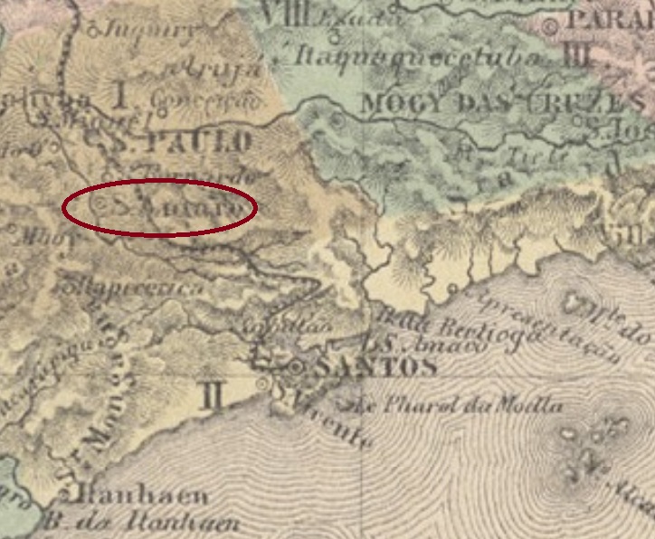
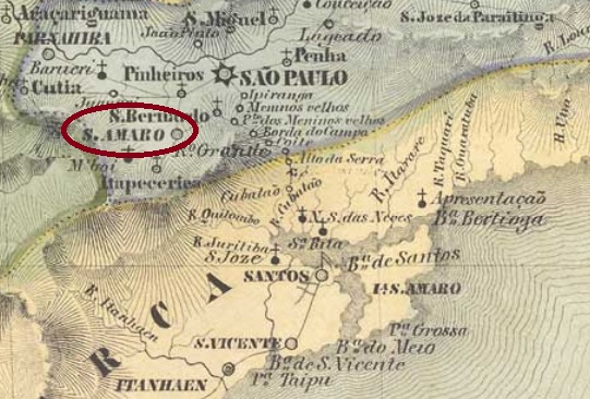
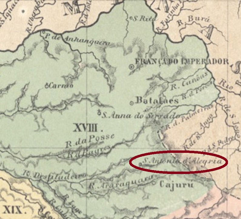
Santo Antonio da Alegria was originally the Cuscuzeiro Chapel, which became in April 1873 a freguesia of the municipality of Cajuru, situated over 300 km north of the provincial capital São Paulo. In March 1885 it ascended to a villa, which was made a town in December 1906.

According to the Imperial Mail Register (Tabella das Agencias do Correio do Imperio) of 1885, the local post office was created in 1856, but such an early date might be a misprint. Instead, the earliest mention of a postal route through Santo Antonio da Alegria was published in August 1875 in the São Paulo press:

Correio Paulistano, August 3, 1875

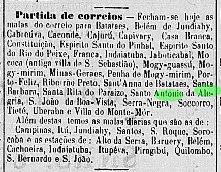
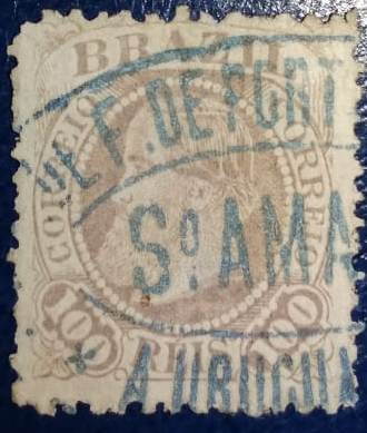
This would mean the post office was created shortly before. Only one imperial cancel was found to date, whose left side is unfortunately missing: SSP-1315b (Coll. José A. Junges) has a double circle with the inscription (S.A. DA) ALEGRIA above and a four-leaf-clover ornament below. Both existing examples are dated 1889.

Mappa da Provincia de São Paulo, 1886

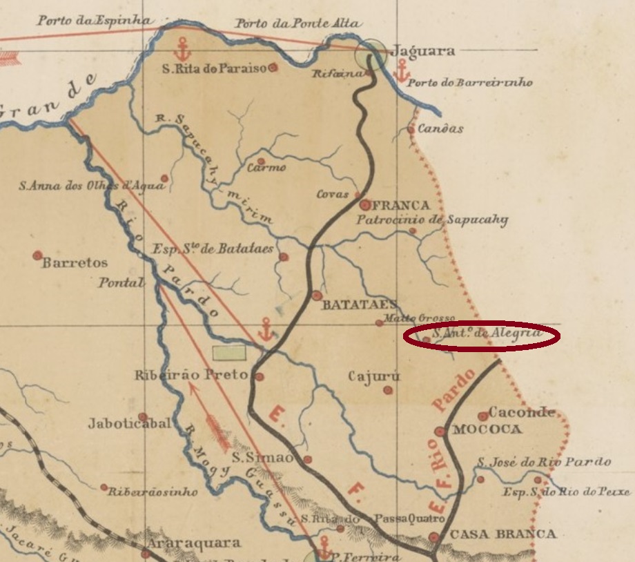
Santo Antonio da Alegria war ursprünglich die Kapelle von Cuscuzeiro, die im April 1873 zu einer Freguesia des Municipio von Cajuru erhoben wurde und über 300 km nördlich der Provinzhauptstadt São Paulo entfernt lag. Im März 1885 stieg sie zur Villa, und im Dezember 1906 zur Stadt auf.

Laut Verzeichnis der kaiserlichen Postämter (Tabella das Agencias do Correio do Imperio) von 1885, das örtliche Postamt ist aus dem Jahr 1856, aber dieses frühe Datum mag ein Druckfehler sein. Stattdessen findet man die früheste Erwähnung einer Postroute durch Santo Antonio da Alegria im August 1875 in der Presse von São Paulo:

Correio Paulistano, 3. August 1875

Möglicherweise entstand die Postagentur kurz vorher. Nur eine Abstempelung der Kaiserzeit war zu finden, wobei hier die linke Seite fehlt: SSP-1315b (Samml. José A. Junges) hat einen Doppelkreis mit der Inschrift (S.A. DA) ALEGRIA oben und einem Ornament in Form eines vierblättrigen Kleeblatts unten. Beide vorhandenen Exemplare sind aus dem Jahr 1889.

Categories
Carimbologia S

Santo Antonio, Santa Catarina (SSC-0245)

Atlas do Imperio do Brasil, 1868

Other names: Rerituba, Santo Antonio de Lisboa (1948)

This Santo Antonio on the island of Santa Catarina was since January 1809 a North Bay district of the later provincial capital Desterro, situated round 20 km away from it. In December 1943 it had the name changed to Rerituba, a tupi-guarani word that means plenty of oysters. The new toponym became by no means popular, and five years later the district received the actual denomination Santo Antonio de Lisboa.

According to the local press, the post office was created in March 1884:

Jornal do Commercio, March 14, 1884

No postal cancel from the empire has appeared until now.

Villiers de l’Ile Adam: Carta (…) da Provincia de Santa Catharina, 1847

Andere Namen: Rerituba, Santo Antonio de Lisboa (1948)

Dieser Santo Antonio auf der Santa Catarina Insel war ab Januar 1809 ein Distrikt an der Nordbucht besagter Insel, der ca. 20 km weg von der späteren Provinzhauptstadt Desterro lag. Im Dezember 1943 der Name wechselte zu Rerituba, ein Begriff der tupi-guarani-Sprache, der etwa Austernreichtum bedeutet. Dieser Ortsname hat sich nicht durchgesetzt, und fünf Jahre später bekam der Distrikt die aktuelle Bezeichnung Santo Antonio de Lisboa.

Wie die Ortspresse berichtet, entstand das lokale Postamt im März 1884:

Jornal do Commercio, 14. März 1884

Keine postalische Abstempelung der Kaiserzeit war bisher zu sehen.

Categories
Carimbologia S

Santo Antonio, Rio Grande do Sul (SRS-0615), Santo Antonio da Patrulha, Rio Grande do Sul (SRS-0420)

Atlas do Imperio do Brasil, 1868

This locality has imperial cancels with slightly modified legends. Therefore, both variants will be presented together here. The freguesia of Santo Antonio da Guarda Velha was founded in 1760, ca. 80 km east of the later provincial capital Porto Alegre, and subordinated to Viamão. It was declared the district of Santo Antonio da Patrulha in October 1795, which ascended to a villa in November 1809. In December 1944 the official name was simplified to Santo Antonio, but in September 1977 the toponym Santo Antonio da Patrulha returned definitively.

We have found two different years for the creation of the local post office. According to Nova Monteiro (Administrações e Agencias Postaes do Brasil Imperio, in Brasil Filatelico/RJ, 1934-5; Reprint SPP 1994-1999), it opened for the first time in October 1831. The Imperial Mail Register (Tabella das Agencias do Correio do Imperio) of 1885, on the other hand, lists this agency from 1874 on, which is probably a reopening year.

The earliest cancel, SRS-0615a, was found on Bull’s Eyes and used at least until 1866, but has probably a pre-philatelic origin, as presented by Henrique B. Ferreira in his Catálogo ilustrado dos carimbos sobre os olhos-de-boi (4th. ed., Porto Alegre, 2017):

SRS-0615a (apud Henrique B. Ferreira, op. cit.)

It was followed by SRS-0420a (Coll. José A. Junges): a double circle with the inscription S. A. DA PATRULHA above and the date at the centre. Only two exemplars seen, both of 1879.

Paulo Ayres (Catálogo de Carimbos Brasil-Império, S. Paulo, 1937, 1942) also shows a mute cancellation with #55, which we believe to refer to this locality:

P. Ayres (op. cit.) #55
Villiers de l’Ile Adam: Carta (…) da Provincia de São Pedro do Sul

Diese Ortschaft hat Poststempel aus der Kaiserzeit, deren Texte leichte Veränderungen aufweisen. Darum werden beide Varianten hier zusammen vorgestellt. Die Freguesia von Santo Antonio da Guarda Velha wurde 1760 bei Viamão gegründet und lag ca. 80 km östlich der späteren Provinzhauptstadt Porto Alegre entfernt. Im Oktober 1795 wurde daraus der Distrikt von Santo Antonio da Patrulha, der im November 1809 zur Villa aufstieg. Im Dezember 1944 wurde der offizielle Name zu Santo Antonio vereinfacht, bevor im September 1977 der alte Ortsname Santo Antonio da Patrulha endgültig zurückkehrte.

Wir haben zwei Entstehungsjahre fürs örtliche Postamt gefunden. Laut Nova Monteiro (Administrações e Agencias Postaes do Brasil Imperio, in Brasil Filatelico/RJ, 1934-5; Reprint SPP 1994-1999) öffnete die Agentur erstmals im Oktober 1831. Das Verzeichnis der kaiserlichen Postämter (Tabella das Agencias do Correio do Imperio) von 1885, andererseits, listet das Postamt ab 1874, wahrscheinlich ein Jahr der Wiedereröffnung.

Der früheste Stempel, SRS-0615a, wurde auf Ochsenaugen bis zumindest 1866 benutzt, hat aber womöglich einen Vorphila-Ursprung. Das Bild stammt aus Henrique B. Ferreiras Catálogo ilustrado dos carimbos sobre os olhos-de-boi (4. Auflage, Porto Alegre, 2017):

SRS-0615a (apud Henrique B. Ferreira, op. cit.)

Ihm folgte SRS-0420a (Samml. José A. Junges): ein Doppelkreis mit der Inschrift S. A. DA PATRULHA oben und dem Datum in der Mitte. Nur zwei Exemplare wurden gesichtet, beide aus 1879.

Paulo Ayres (Catálogo de Carimbos Brasil-Império, S. Paulo, 1937, 1942) zeigt auch einen stummen Stempel unter Nr.55, den wir auch dieser Ortschaft zuschreiben würden:

P. Ayres (op. cit.) Nr. 55
Categories
Carimbologia S

Santo Antonio, Rio Grande do Norte (SRN-0235)

Arthur D. Ribeiro: Mappa do Rio Grande do Norte, 1923

Santo Antonio was from June 1886 on a district of the municipality of Goianinha, situated round 80 km southwest of the provincial capital Natal. In July 1890 it ascended to a villa and received an own municipality in January 1892.

According to the Imperial Mail Register (Tabella das Agencias do Correio do Imperio) of 1885, a local post office was created as early as 1836. This is probably a misprint, given that neither postal records nor cancels exist from a time up to fifty years before the village became a district. Instead, in May 1875 the creation of a postal agency in Santo Antonio in December 1874 was reported by the province president:

Relatorio do Presidente da Provincia/RN, May 1875

No postmark from the Empire could be safely identified until now.

GoogleMaps

Santo Antonio war ab Juni 1886 ein Distrikt im Municipio von Goianinha und lag rund 80 km südwestlich der Provinzhauptstadt Natal entfernt. Im Juli 1890 stieg er zur Villa auf, im Januar 1892, zum eigenen Município.

Laut Verzeichnis der kaiserlichen Postämter (Tabella das Agencias do Correio do Imperio) von 1885 gab es dort bereits ab 1836 ein Postamt. Das dürfte ein Druckfehler sein (oder die Postagentur war von kurzer Dauer), da es keine weiteren Spuren von Postbetrieb dort aus der Zeit gab, 50 Jahre bevor Santo Antonio zum Distrikt erklärt wurde. Stattdessen meldete der Provinzpräsident in seinem Bericht vom Mai 1875 die Gründung eines Postamts in Santo Antonio im Dezember 1874:

Relatorio do Presidente da Provincia/RN, Mai 1875

Keine Poststempel der Kaiserzeit konnten bisher mit Sicherheit ermittelt werden.

Categories
Carimbologia S

Santo Antonio, Piauhy (SPI-0160)

Atlas do Imperio do Brasil, 1868

Other names: Santo Antonio do Surubim, Santo Antonio de Campo Maior

See also Campo Maior (Koester: Carimbologia VIII)

The long list of the villages named Santo Antonio in imperial Brazil starts in the Piauí province. The parish of Santo Antonio do Surubim (= St. Anthony of the Catfish) was established in June 1761 as the second one in Piauí, situated over 350 km north of the later provincial capital Oeiras. In August 1762 it was the main location of the villa and municipality of Campo Maior, which ascended to a town in December 1889.

According to R. Koester (Carimbologia VIII) the local post office was created in 1876, but he had found no imperial cancel featuring Campo Maior. On the other hand, one early cancellation with Santo Antonio was found, despite the later date of 1894: SPI-0160b (Coll. FM) has a double circle with the inscriptions S. ANTONIO above and (PIAUHY) below. At the centre, the cancellation date of January 1893 was corrected by hand to 1894.

Villiers de l’Ile Adam: Carta (…) da Provincia do Piauhy, 1850

Andere Namen: Santo Antonio do Surubim, Santo Antonio de Campo Maior

Siehe auch Campo Maior (Koester: Carimbologia VIII)

Die lange Auflistung der brasilianischen Ortschaften des Kaiserreichs, die Santo Antonio hießen, beginnt in der Provinz Piauí. Die Pfarrei von Santo Antonio do Surubim (= Hl. Antonius des Welses) war im Juni 1761 die zweite Freguesia, die in Piauí errichtet wurde und lag über 350 km nördlich der späteren Provinzhauptstadt Oeiras entfernt. Im August 1762 wurde sie der Sitz des neuen Município von Villa de Campo Maior, und stieg im Dezember 1889 zur Stadt auf.

R. Koester berichtet in seiner Carimbologia VIII, das örtliche Postamt wurde 1876 errichtet. Er konnte aber kein Poststempel mit Campo Maior finden. Dafür konnte ein früher Stempel  für Santo Antonio ermittelt werden, datiert allerdings erst von 1894: SPI-0160b (Samml. FM) hat einen Doppelkreis mit den Inschriften S. ANTONIO oben und (PIAUHY) unten. Das Stempeldatum vom Januar 1893 in der Mitte wurde nachträglich per Hand auf 1894 korrigiert.

Categories
Carimbologia S

Santo Angelo, Rio Grande do Sul (SRS-0415)

Atlas do Imperio do Brasil, 1868

The territory of the villa of Santo Angelo was originally distributed between the muncipalities of Santa Cruz and São Borja, in the Mission region of the southern province São Pedro do Rio Grande, over 400 km northwest of the capital Porto Alegre. In March 1873 it ascended to a villa in own municipality.

Two dates for the the local post office were found. According to the Imperial Mail Register (Tabella das Agencias do Correio do Imperio) of 1885 it was created already in 1877, but the Provincial President’s Report for 1879 (Relatório do Presidente da Provincia) asserts it began to operate only in August 1878:

Relatorio do Presidente da Provincia/RS, 1879

Three early cancels could be identified. SRS-0415a (Coll. José A. Junges) was used in the period 1881-1889 in black and blue. It has a double circle with the inscription S. ANGELO above and the date at the centre. The following cancels, SRS-0415b and SRS-0415c (both examples from the J.A. Junges collection), have the same features: a double circle with the inscriptions SANTO ANGELO above and (S. PEDRO DO SUL) below. with dates at the centre. In the former, used 1892, the letters are narrow/high and there are gaps between inscriptions, whereas in the latter of 1893 the letters are wide, without gap between inscriptions.

Villiers de l’ile Adam: Carta (…) da Provincia de S. Pedro do Sul, 1847

Das Gebiet der Villa von Santo Angelo war ursprünglich zwischen den Municípios von Santa Cruz und São Borja verteilt, in der Region der Missionen der südlichen Provinz São Pedro do Rio Grande, über 400 km nordwestlich der Hauptstadt Porto Alegre entfernt. Im März 1873 stieg Santo Angelo zur Villa im eigenen Município auf.

Zwei Daten fürs örtliche Postamt wurden ermittelt. Das Verzeichnis der kaiserlichen Postämter (Tabella das Agencias do Correio do Imperio) von 1885 listet es bereits ab 1877 auf, aber der Bericht des Provinzpräsidenten für 1879 (Relatório do Presidente da Provincia) besagt, das Postamt ging erst im August 1878 in Betrieb:

Relatorio do Presidente da Provincia/RS, 1879

Drei frühe Stempel wurden gefunden. SRS-0415a (Samml. José A. Junges) war in schwarz und blau zwischens 1881 und 1889 im Umlauf. Hier haben wir einen Doppelkreis mit der Inschrift S. ANGELO oben und dem Datum in der Mitte. Die folgenden Abstempelungen, SRS-0415b und SRS-0415c (beide Exemplare aus der Samml. J.A. Junges), haben die gleichen Merkmale: ein Doppelkreis mit den Inschriften SANTO ANGELO oben und (S. PEDRO DO SUL) unten, dazu Daten in der Mitte. Beim ersten Stempel, aus dem Jahr 1892, sind die Buchstaben eher schmal und hoch, und es gibt Leerräume zwischen den Inschriften, während beim zweiten, aus 1893, die Buchstaben sind breit, die Leerräume zwischen Inschriften sind nicht mehr da.

Categories
Carimbologia S

Santo Amaro do Ipitanga, Bahia (SBA-0682)

Villiers de l’Ile Adam: Carta (….) da Provincia da Bahia, 1848

Other names: Ipitanga, Lauro de Freitas (1962)

Santo Amaro do Ipitanga had belonged to the municipalities of Abrantes, Salvador and Montenegro (1880), before it changed again to Salvador as a district in 1932. Situated round 30 km northeast of the provincial capital, it was called Ipitanga (= red river, in tupi-guarani) from December 1953 on, and became an own municipality in July 1962, named Lauro de Freitas. This was a tribute to a politician from Bahia (1901-1950) who died at an airplane accident.

The opening date for the post office is still to be found, according to the local preses, it may have taken place around 1885. No cancel from the Empire has been found until now.

OpenStreetMap

Andere Namen: Ipitanga, Lauro de Freitas (1962)

Santo Amaro do Ipitanga gehörte als Freguesia oder Distrikt zu den Município vou Abrantes, Salvador und Montenegro (1880), bevor die Ortschaft 1932 wieder zu Salvador wechselte. Der Distrikt lag rund 30 km nordöstlich der Provinzhauptstadt entfernt und hieß ab Dezember 1953 Ipitanga (= roter Fluss, in Tupi-guarani). Im Juli 1962 stieg er zum Município von Lauro de Freitas auf. Der Name soll an einem Politiker aus Bahia erinnern (1901-1950), der bei einem Flugzeugunfall starb.

Das Entstehungsdatum fürs lokale Postamt konnte leider noch nicht ermittelt werden, dürfte aber laut Pressemeldungen um 1885 stattgefunden haben. Kein Poststempel der Kaiserzeit wurde ebenso wenig gefunden.

Categories
Carimbologia S

Santo Amaro das Brotas, Sergipe (SSE-0160)

Atlas do Imperio do Brasil, 1868

The freguesia of Santo Amaro das Brotas (or simply Santo Amaro) was founded in November 1783 on the north bank of the Sergipe River, over 50 km north of the later provincial capital São Christovão. It became a district of the municipality of Maroim in February 1835 and ascended to a villa in own municipality six months later. In 1911 the toponym was officially simplified to Santo Amaro, but the additional das Brotas returned in December 1943.

According to Nova Monteiro (Administrações e Agencias Postaes do Brasil Imperio, in Brasil Filatelico/RJ, 1934-5; Reprint SPP 1994-1999), the local post office was created in October 1864. No imperial cancel could be safely identified until now.

Villiers de l’Ile Adam (Carta (…) das Provincias de Pernambuco, Alagoas e Sergipe, 1848

Die Freguesia von Santo Amaro das Brotas (oder einfach Santo Amaro) wurde im November 1783 am Nordufer des Flusses Sergipe gegründet und lag über 50 km nördlich der künftigen Provinzhauptstadt São Christovão entfernt. Sie wurde ein Distrikt im Município von Maroim im Februar 1835 und stieg sechs Monate später zur Villa im eigenen Município auf. 1911 wurde der Ortsname zu Santo Amaro vereinfacht, aber der Zusatz das Brotas kehrte ab Dezember 1943 zurück.

Das örtliche Postamt wurde durch Nova Monteiro (Administrações e Agencias Postaes do Brasil Imperio, in Brasil Filatelico/RJ, 1934-5; Reprint SPP 1994-1999) mit Entstehungsdatum im Oktober 1864 angegeben. Kein Poststempel der Kaiserzeit konnte bisher sicherlich identifiziert werden.

Categories
Carimbologia S

Santo Amaro, São Paulo (SSP-1310)

Atlas do Imperio do Brasil, 1868

The Santo Amaro in the São Paulo province was already a villa in own municipality as early as July 1832. Situated ca. 16 km southwest of the provincial capital, it was absorbed by it in February 1935, then receiving the actual district status.

According to the Imperial Mail Register (Tabella das Agencias do Correio do Imperio) of 1885, the local post office was created in 1876. Probably the agency started operations in January 1877, as reported by the local press:

Correio Paulistano, January 28, 1877

One imperial cancel could be safely identified: SSP-1310a (Coll. José A. Junges) has a double circle with the inscriptions STO. AMARO above and (S. PAULO) below. The date found at the centre was of 1887.

Villiers de l’Ile Adam: Carta (…) da Provincia de São Paulo, 1847

Dieser Santo Amaro in der Provinz São Paulo war bereits im Juli 1832 eine Villa im eigenen Município. Die Nähe zur Provinzhauptstadt – es sind lediglich 16 km nach Südwesten – wurde der Gemeinde doch zum Verhängnis: im Februar 1935 wurde Santo Amaro als Distrikt der Metropole eingemeindet.

Laut Verzeichnis der kaiserlichen Postämter (Tabella das Agencias do Correio do Imperio) von 1885 gibt es dort ein Postamt seit 1876. Der Postbetrieb fing wohl erst Anfang 1877 an, wie die Lokalpresse berichtet:

Correio Paulistano, 28. Januar 1877

Ein Stempel des Kaiserreichs konnte zweifelsfrei ermittelt werden: SSP-1310a (Samml. José A. Junges) hat einen Doppelkreis mit den Inschriften STO. AMARO oben und (S. PAULO) unten. Das Datum in der Mitte entstammt dem Jahr 1887.

Categories
Carimbologia S

Santo Amaro, Rio Grande do Sul (SRS-0410)

Atlas do Imperio do Brasil, 1868

Another name: Santo Amaro do Sul (1939)

This Santo Amaro in the São Pedro do Rio Grande province was founded in the late 18th century and became in April 1809 a district of the municipality of Rio Pardo. It was situated on the north bank of the Jacuhy River, nearly 100 km west of the provincial capital Porto Alegre, and passed later to the newly created municipalities of Triumpho (1831) and Taquary (1849), before emancipating as a villa in May 1881. The construction of the Margem train station at the conjunction of the Taquary and Jacuhy Rivers in 1883 caused the decadence of Santo Amaro, which has continuosly shrunk in population and importance since then. Since July 1939 it is the district of Santo Amaro do Sul, in the municipality of General Câmara, a town that originated from the Margem station.

According to the Imperial Mail Register / Verzeichnis der kaiserlichen Postämter (Tabella das Agencias do Correio do Imperio) of 1885, the local post office was created in 1881. Two imperial cancels were found: SRS-0410a (Coll. José A. Junges) was found in black and violet with dates between 1887 and 1897 at the centre. In the double circle there is the inscription S. AMARO above and a diamond ornament below, which is formed by four small diamonds. SRS-0410b (Coll. Fuad Ferreira Fo.) is a train station cancel, used from ca. 1883 on. Since it was found after the printing of Carimbologia S1, so it will be shown here:

SRS-0410b (Coll. Fuad Ferreira Fo.)
Villiers de l’Ile Adam: Carta (…) da Província de S. Pedro do Sul, 1847

Anderer Name: Santo Amaro do Sul (1939)

Dieser Santo Amaro in der Provinz São Pedro do Rio Grande wurde im späten 18. Jahrhundert gegründet und im April 1809 als Distrikt des Município von Rio Pardo eingemeindet. Er lag am Nordufer des Flusses Jacuhy, fast 100 km westlich der Provinzhauptstadt Porto Alegre entfernt, und ging später an anderen Gemeinden über, je nachdem sie selbständig wurden : Triumpho (1831) und Taquary (1849). Im Mai 1881 wurde dann aus Santo Amaro eine Villa im eigenen Município. Der Bau des Bahnhofs Margem 1883 an der Mündung des Flusses Taquary in den Jacuhy leitete die Dekadenz von Santo Amaro ein, der seitdem kontinuierlich an Population und Wirtschaftskraft verlor. Seit Juli 1939 ist er der Distrikt von Santo Amaro do Sul im Município von General Câmara, eine Stadt, die aus dem Margem-Bahnhof entstanden ist.

Laut Verzeichnis der kaiserlichen Postämter (Tabella das Agencias do Correio do Imperio) von 1885 gibt es das Postamt dort seit 1881. Zwei Stempel aus dem Kaiserreich sind bekannt: SRS-0410a (Samml. José A. Junges) wurde in schwarz und violett gefunden, mit Daten zwischen 1887 und 1897 in der Mitte. Im Doppelkreis liest man die Inschrift S. AMARO oben; unten befindet sich ein rautenförmiges Ornament, das aus vier kleinen Rauten besteht. SRS-0410b (Samml. Fuad Ferreira Fo.) ist ein Bahnhofsstempel, der ab ca. 1883 verwendet wurde. Da dieser Stempel nach dem Redaktionsschluss von Carimbologia S1 auftauchte, wird er hier abgebildet:

SRS-0410b (Samml. Fuad Ferreira Fo.)