Categories
Carimbologia S

São Felix, Goiás (SGO-0182)

Atlas do Imperio do Brasil, 1868

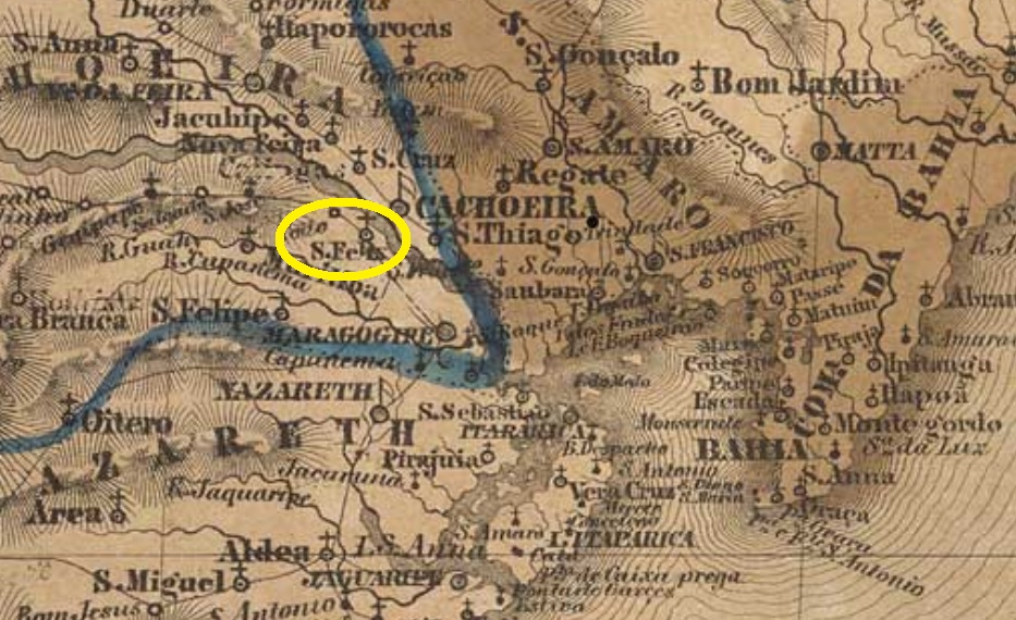
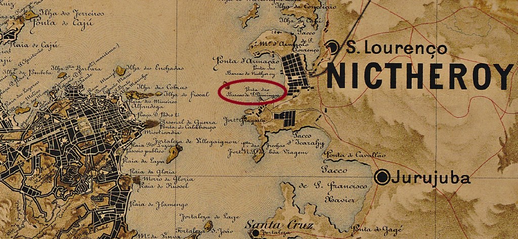
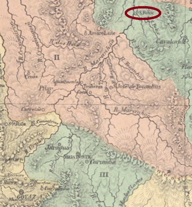
This was a small settlement in the municipality of Cavalcante, more than 500 km northeast of the provincial capital Goyaz (today Goiás Velho). The village became an arraial in November 1831 and experienced a fast development through the discovery of gold deposits. These were soon exhausted, however, and S. Felix was then abandoned by the gold diggers. Today, the place has disappeared from the map, and remains only through its beautiful waterfalls in the memory of its visitors.

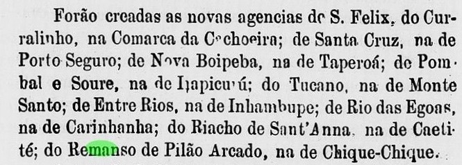
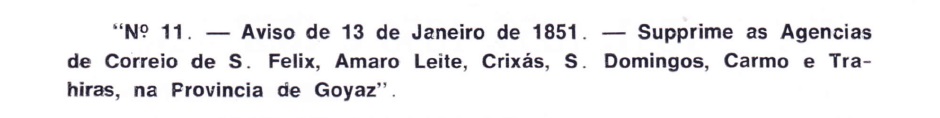
According to Nova Monteiro (Administrações e Agencias Postaes do Brasil Imperio, in Brasil Filatelico/RJ, 1934-5; Reprint SPP 1994-1999) there was a post office there as early as March 1829, but it was closed again in January 1851, as Aureo G. Santos reports in Agências de Correio Criadas e Suprimidas 1851, 1855, 1856 e 1857 (Brasil Filatélico 181, 1977):

Aureo G. Santos (op. cit.)

No imperial post cancel from this S. Felix could be found so far.

Villiers del’Ile Adam: Carta (…) da Provincia de Goyaz, 1849

São Felix war eine kleine Siedlung im Município von Cavalcante, die über 500 km nordöstlich der Provinzhauptstadt Goyaz (heute Goiás Velho) entfernt lag. Die Ortschaft wurde im November 1831 ein Arraial und erfuhr einen raschen Aufschwung durch die Entdeckung von Goldvorkommen. Dieses wurde aber bald ausgeschöpft, und São Felix wurde anschließend von den Goldgräbern verlassen. Heute ist ist der Ort von der Karte verschwunden, und bleibt nur durch seine schönen Wasserfälle in der Erinnerung seiner Besucher.

Laut Nova Monteiro (Administrações e Agencias Postaes do Brasil Imperio, in Brasil Filatelico/RJ, 1934-5; Reprint SPP 1994-1999) gab es dort ein Postamt bereits im März 1829, das allerdings im Januar 1851 wieder geschlossen wurde, wie Aureo G. Santos zu berichten weiß (Agências de Correio Criadas e Suprimidas 1851, 1855, 1856 e 1857, in Brasil Filatélico 181, 1977):

              Aureo G. Santos (op. cit.)

Kein Stempel der Kaiserzeit aus diesem S. Felix konnte bisher gefunden werden.

Categories
Carimbologia S

São Felix, Bahia (SBA-0810)

Atlas do Imperio do Brasil, 1868

From October 1857 on, São Felix was a district in the municipality of Cachoeira, located on the west bank of the Paraguassu River, about 120 km northwest of the provincial capital Salvador da Bahia. In December 1889 the village was elevated to a villa and is a town since October 1890.

The local post office was probably built between the end of 1875 and the beginning of 1876, as its creation is listed in the provincial government’s report of May 1876:

Relatorio do Presidente da Provincia, May 1876

Two early cancellations were found, both with republican dates. SBA-0810a (image from the internet) has a double circle with the inscription S. FELIX above. The dates at the centre are from 1890 to 1895. SBA-0810b (Coll. Fuad Ferreira Fo.) is a handwritten cancel used on an issue from 1893. One reads S. Feli(x) and a date 16-9-(…)

Villiers de l’Ile Adam: Carta (…) da Provincia da Bahia, 1848

São Felix war ab Oktober 1857 ein Distrikt im Município von Cachoeira, der am Westufer des Flusses Paraguassu lag, ca. 120 km nordwestlich der Provinzhauptstadt Salvador da Bahia. Im Dezember 1889 wurde der Ort zur Villa erhoben, und ist eine Stadt seit Oktober 1890.

Das örtliche Postamt wurde wohl zwischen Ende 1875 und Anfang 1876 errichtet, da seine Entstehung im Bericht der Provinzregierung vom Mai 1876 angepriesen wird:

Relatorio do Presidente da Provincia, Mai 1876

Zwei frühe Entwertungen waren zu finden, beide mit Daten aus der Republik. SBA-0810a (Abb. aus dem Internet) hat einen Doppelkreis mit der Inschrift S. FELIX oben. Die Daten in der Mitte gehen von 1890 bis 1895. SBA-0810b (Samml. Fuad Ferreira Fo.) ist eine handgeschriebene Entwertung, die auf einer Ausgabe aus 1893 verwendet wurde. Man liest S. Feli(x), dazu ein Datum 16-9-(…).  

Categories
Carimbologia S

São Felippe, Bahia (SBA-0610)

Atlas do Imperio do Brasil, 1868

In the province of Bahia, São Felippe (also written Philippe or Felipe) was formerly a freguesia in the municipality of Maragogipe, which is located almost 90 km west of the provincial capital Salvador and was elevated to villa in May 1880. Since March 1938, the locality has been a town.

As can be read in the Imperial Mail Register (Tabella das Agencias do Correio do Imperio) of 1885, there is a post office there since 1881, which is also confirmed by the annual report of the provincial president for 1882:

Relatório do Presidente da Provincia, January 1882

An early postmark was found: SBA-0610a (Coll. José A. Junges) consists of a double circle with inscription S. FELIPPE above. The only copy has a date of 1893 at the centre.

Villiers de l’Ile Adam: Carta (…) da Provincia da Bahia, 1848

São Felippe (auch Philippe oder Felipe geschrieben) in der Provinz Bahia war früher eine Freguesia im Município von Maragogipe, die knapp 90 km Luftlinie westlich der Provinzhauptstadt Salvador liegt und im Mai 1880 zur Villa erhoben wurde. Seit März 1938 ist die Ortschaft eine Stadt.

Wie man im Verzeichnis der kaiserlichen Postämter (Tabella das Agencias do Correio do Imperio) von 1885 nachlesen kann, gibt es dort ein Postamt seit 1881, was auch durch den Jahresbericht des Provinzpräsidenten für 1882 bestätigt wird:

Relatório do Presidente da Provincia, Januar 1882

Ein früher Poststempel wurde gefunden: SBA-0610a (Samml. José A. Junges) besteht aus einem Doppelkreis mit Inschrift S. FELIPPE oben. Das einzige Exemplar trägt ein Datum aus 1893 in der Mitte.

Categories
Carimbologia S

São Domingos de Rio do Peixe, Minas Gerais (SMG-2250)

Atlas do Imperio do Brasil, 1868

Another name: Dom Joaquim (1938)

The last Dominic – for now – of the province of Minas Gerais is São Domingos do Rio do Peixe (= From the Fish River, at a time when you could fish a lot). It was a district do Serro (now Conceição do Mato Dentro) and was located less than 300 km north of the provincial capital Ouro Preto. In December 1938, it ascended to the municipality of Dom Joaquim. The name is a tribute to the former archbishop of Diamantina, Joaquim Silvério de Souza.

Paula Sobrinho (História Postal de Minas Gerais, Belo Horizonte, 1977) writes that the local post office was created in August 1883. The earliest postmark we have seen so far is SMG-2250a (Coll. José A. Junges): a double circle with the inscription S. DOMINGOS DE RIO DO PEIXE above and an ornament in cross form below. Dates at the centre from 1890 until 1899. 

Villiers de l’Ile Adam: Carta (…) da Provincia de Minas Geraes, 1849

Anderer Name: Dom Joaquim (1938)

Der letzte Dominikus – fürs Erste – der Provinz Minas Gerais ist São Domingos de Rio do Peixe (= vom Fischfluss, aus einer Zeit also, in der man viel angeln konnte). Die Ortschaft war ab Oktober 1870 ein Distrikt von Conceição do Serro (heute Conceição do Mato Dentro) und lag knapp 300 km nördlich der Provinzhauptstadt Ouro Preto entfernt. Im Dezember 1938 stieg sie zum Município von Dom Joaquim auf. Der Name huldigt den früheren Erzbischof von Diamantina, Joaquim Silvério de Souza.

In seiner História Postal de Minas Gerais (Belo Horizonte, 1977), schreibt Paula Sobrinho, dass das örtliche Postamt im August 1883 entstanden ist. Der früheste Poststempel, den wir bisher gesichtet haben, ist SMG-2250a (Samml. José A. Junges): ein Doppelkreis mit der Inschrift S. DOMINGOS DE RIO DO PEIXE oben und einem Ornament in Kreuzform unten. Daten in der Mitte von 1890 bis 1899.  

Categories
Carimbologia S

São Domingos do Prata, Minas Gerais (SMG-2245)

Atlas do Imperio do Brasil, 1868

This other Saint Dominic of the province of Minas Gerais is another locality dedicated to Dominic de Guzmán (1170-1221), founder of the Order of the Dominicans. It is situated almost 150 km northeast of the provincial capital Ouro Preto, on the western bank of the Rio da Prata (not the famous river that separates Uruguay from Argentina, but rather its 215 km Brazilian cousin, a tributary of the Tejuco River). In July 1843 the freguesia was established, which would soon be elevated to a village. Since March 1890 is a city and municipality.

In his História Postal de Minas Gerais (Belo Horizonte, 1997) writes Paula Sobrinho that the local post office was created in October 1875. The only known imperial cancel so far is SMG-2245a (internet image): a double circle with the inscription S. DOMINGOS DO PRATA above and an ornament below, formed by four arrowheads in cross. The dates at the centre were found for the period from 1884 to 1893.

Villiers de l’Ile Adam: Carta (…) da Provincia de Minas Geraes, 1849

Dieser andere Skt. Dominikus der Provinz Minas Gerais ist ein weiterer Ort, der Dominikus (1170-1221), dem Gründer des Dominikanerordens, gewidmet ist. Er liegt am westlichen Ufer des Rio da Prata (nicht der berühmte Fluss, der Uruguay von Argentinien trennt, aber sein kleiner, 215 km langer Namensvetter aus Minas Gerais, ein Nebenfluss des Tejuco), fast 150 km nordöstlich der Provinzhauptstadt Ouro Preto. Im Juli 1843 wurde die Freguesia gegründet, die bald zum Dorf erhoben werden sollte. Seit März 1890 ist São Domingos do Prata eine Stadt und Município.

In seiner História Postal de Minas Gerais (Belo Horizonte, 1997) schreibt Paula Sobrinho, dass das örtliche Postamt im Oktober 1875 errichtet wurde. Der bisher einzige bekannte kaiserliche Stempel ist SMG-2245a (Internetbild): ein Doppelkreis mit der Inschrift S. DOMINGOS DO PRATA oben und einem Ornament unten, gebildet von vier Pfeilspitzen in Kreuz. Die Daten in der Mitte wurden für die Zeit von 1884 bis 1893 gefunden.

Categories
Carimbologia S

São Domingos de Marianna, Minas Gerais (SMG-2235)

Provincia de Minas Geraes, 1873

Other names: São Domingos, Vasconcelos, Diogo de Vasconcelos (1928)

From September 1881 on, this village was a freguesia in the municipality of Marianna, about 60 km east of the provincial capital Ouro Preto. In September 1923, the name changed to Vasconcelos, when the locality was elevated to a district. Five years later, it was called Diogo de Vasconcelos, which has been an independent municipality since December 1962. The name is a tribute to Diogo Luís de A.P. de Vasconcelos (1843-1927), a historian, politician, journalist, and lawyer from the region.

As Paula Sobrinho reports in his Historia Postal de Minas Gerais (Belo Horizonte, 1997), there has been a post office there since February 1882. The only found cancel to date, SMG-2235a (Coll. José A. Junges), consists of a double circle with the inscriptions S. DOMINGOS above and (MUNo. MARIANNA) below. The only copy has a date from 1890 at the centre.

Mappa do Estado de Minas Geraes, 1910

Andere Namen: São Domingos, Vasconcelos, Diogo de Vasconcelos (1928)

Diese Ortschaft war ab September 1881 eine Freguesia im Município von Marianna, die rund 60 km östlich der Provinzhauptstadt Ouro Preto entfernt lag. Im September 1923 wechselte der Name zu Vasconcelos, als der Ort zu einem Distrikt erhoben wurde. Fünf Jahre später hieß er Diogo de Vasconcelos, der seit Dezember 1962 als eigenständiger Município ist. Der Name soll an Diogo Luís de A.P. de Vasconcelos (1843-1927) erinnern, einem Historiker, Politiker, Journalist und Jurist aus der Gegend.

Wie Paula Sobrinho in seiner Historia Postal de Minas Gerais (Belo Horizonte, 1997) berichtet, gibt es dort ein Postamt seit Februar 1882. Der bisher einzige überlieferte Poststempel, SMG-2235a (Samml. José A. Junges), besteht aus einem Doppelkreis mit den Inschriften S. DOMINGOS oben und (MUNo. MARIANNA) unten. Das einzige Exemplar hat ein Datum aus 1890 in der Mitte.

Categories
Carimbologia S

São Domingos da Boa Vista, Pará (SPA-0215)

Atlas do Imperio do Brasil, 1868

Other names: Sao Domingos do Capim (1932, 1961), Capim (1943)

From 1758 on, the Town of Domingos da Boa Vista was a freguesia of Belém do Pará, which was located close to the Guamá River, about 100 km southeast of the later provincial capital. In December 1890, the village rose to a villa, which from August 1932 was called São Domingos do Capim (= of the Meadow). The new name was shortened to Capim in 1943, but returned officially in January 1961.

According to the Imperial Mail Register (Tabella das Agencias do Correio do Imperio) of 1885, there has been a post office there since 1882, but this is not correct, since in March 1882 the probably already existing agency received a higher rating, as reported by the Rio Press:

O Globo/RJ, March 24, 1882

Since the post office is listed in the Postal Guide (Guia Postal do Império do Brazil) of 1880 and was already in operation in 1877, according to the provincial report (Relatório do Presidente da Província) of February 1881, it must have been opened by 1876 at the latest. No postmark of the imperial era could be found so far.

Villiers de l’Ile Adam: Carta (…) da Provincia do Pará, 1850

Andere Namen: São Domingos do Capim (1932, 1961), Capim (1943)

São Domingos da Boa Vista war ab 1758 eine Freguesia von Belém do Pará, die nah am Fluss Guamá lag, ca. 100 km südöstlich der späteren Provinzhauptstadt entfernt. Im Dezember 1890 stieg der Ort zur Villa, die ab August 1932 São Domingos do Capim (= von der Weide) hieß. Der neue Name wurde 1943 zu Capim verkürzt, kehrte aber im Januar 1961 offiziell wieder.

Laut Verzeichnis der kaiserlichen Postämter (Tabella das Agencias do Correio do Imperio) von 1885 gibt es dort ein Postamt seit 1882, aber diese Angabe stimmt nicht, da im März 1882 die wohl bereits bestehende Agentur eine höhere Einstufung erhielt, wie die Rio Presse berichtet:

O Globo/RJ, 24. März 1882

Da das Postamt im Postführer (Guia Postal do Império do Brazil) von 1880 aufgelistet wird und laut provinzialem Bericht (Relatório do Presidente da Província) vom Februar 1881 bereits 1877 im Betrieb war, muss dieses spätestens 1876 eröffnet worden sein. Kein Poststempel der Kaiserzeit konnte bisher gefunden werden.

Categories
Carimbologia S

São Domingos do Arassuahy, Minas Gerais (SMG-2240)

Atlas do Imperio do Brasil, 1868

Another name: Virgem da Lapa (1948)

The Arassuahy (today written Araçaí) is a tributary on the right bank of the Jequitinhonha River in northeastern Minas Gerais. The name probably has an Indian origin and probably means river of the red macaws. From a settlement on the north shore from the early 18th century, the parish of São Domingos was founded in 1840 in the municipality of Minas Novas, about 650 km northeast of the provincial capital Ouro Preto. The village rose to a villa in September 1891 and to a city in December 1948, now under the current name Virgem da Lapa (= Virgin of the Grotto).

According to Paula Sobrinho (História Postal de Minas Gerais, Belo Horizonte, 1997), the local post office was established in March 1885. The only postmark so far bears a date from the Republic but could be much older. SMG-2240a (Coll. Márcio Protzner) has a double circle with the inscription S. DOMINGOS DO ARASSUAHY above and the date (from 1902) at the centre.

Villiers de l’Ile Adam: Carta (…) da Provincia de Minas Geraes, 1849

Anderer Name: Virgem da Lapa (1948)

Der Arassuahy (heute Araçuaí geschrieben) ist ein ca. 400 km langen Zufluss am rechten Ufer des Jequitinhonha in Nordosten von Minas Gerais. Der Name hat wohl einen indianischen Ursprung und soll Fluss der roten Aras bedeuten. Aus einer Siedlung am Nordufer aus dem frühen 18. Jahrhundert wurde 1840 die Pfarrei von São Domingos in der Gemeinde Minas Novas gegründet, knapp 650 km nordöstlich der Provinzhauptstadt Ouro Preto entfernt. Der Ort stieg im September 1891 zur Villa und im Dezember 1948 zur Stadt auf, nun unter dem aktuellen Namen Virgem da Lapa (= Jungfrau der Grotte).

Laut Paula Sobrinho (História Postal de Minas Gerais, Belo Horizonte, 1997), entstand das örtliche Postamt im März 1885. Der bisher einzige Poststempel trägt zwar ein Datum aus der Republik, könnte aber noch wesentlich älter sein. SMG-2240a (Samml. Márcio Protzner) hat einen Doppelkreis mit der Inschrift S. DOMINGOS DO ARASSUAHY oben und das Datum (aus 1902) in der Mitte.

Categories
Carimbologia S

São Domingos (train station/Bahnhof), Rio de Janeiro (SRJ-0920)

E. de. F. Central do Brasil, 1890

Another name: Aré station (ca. 1940)

São Domingos was the name of a large fazenda on the west bank of the Muriahé River in the Campos district of the province of Rio de Janeiro, which was located about 400 km northeast of the imperial capital. The large estate gave the name to a small railway station of the E.F. Carangola Railway Company, which started operations in June 1881. In November 1885, the station and surrounding area were assigned to the new municipality of Natividade do Itaperuna (today only Itaperuna). Now the village is in the district of N. Sra. da Penha.

The railway line also changed hands frequently: in 1890 to the Cia. Barão de Araruama, and a few months later to E. F. Leopoldina. In the 1940s, the station was renamed Aré, today a small hamlet with the simple chapel of S. Domingos de Gusmão. From 1975 until the operation end in 1977, the railway line belonged to the Rede Ferroviária Federal Company. The station building was demolished and today its exact location in unknown (estacoesferroviarias.com.br). 

As Paulo Novaes (agenciaspostais.com.br) reports, there has been a station post office in São Domingos since October 1888. Novaes also provides the illustration of the first station cancel: SRJ-0920a consists of a double circle with the inscription E. DE S. DOMINGOS above and (E.F. CARANGOLA) below, along with a date from February 1890 at the centre.

Almanak Laemmert, 1892

Anderer Name: Bahnhof Aré (ca. 1940)

São Domingos hieß eine große Fazenda am Westufer des Flusses Muriahé im Bezirk Campos im Norden der Provinz Rio de Janeiro, die knapp 400 km nordöstlich der kaiserlichen Hauptstadt entfernt lag. Der Großgrundbesitz gab den Namen einem kleinen Bahnhof der E.F. Carangola Eisenbahngesellschaft, der den Betrieb im Juni 1881 aufgenommen hat. Im November 1885 wurden Bahnhof und Umgebung der neuen Gemeinde Natividade do Itaperuna (heute nur Itaperuna) zugesprochen. Heute liegt die Ortschaft im Distrikt von N. Sra. da Penha.

Auch die Bahnlinie wechselte häufig den Besitzer: 1890 zur Cia. Barão de Araruama, und ein Paar Monate später zur E. F. Leopoldina. In den 40er Jahren des 20. Jahrhunderts wurde der Bahnhof zu Aré umbenannt, heute ein kleiner Weiler mit der schlichten Kapelle S. Domingos de Gusmão. Von 1975 bis zum Betriebsende 1977 gehörte die Bahnlinie der Rede Ferroviária Federal. Das Bahnhofsgebäude wurde abgerissen und heute weiß man nicht mehr, wo es sich genau befand (estacoesferroviarias.com.br).  

Wie Paulo Novaes (agenciaspostais.com.br) berichtet, gab es ein Bahnhofspostamt São Domingos seit Oktober 1888. Novaes liefert auch die Abbildung des wohl ersten Bahnhofsstempels: SRJ-0920a besteht aus einem Doppelkreis mit der Inschrift E. DE S. DOMINGOS oben und (E.F. CARANGOLA) unten, dazu ein Datum aus Februar 1890 in der Mitte.

Categories
Carimbologia S

São Domingos, Rio de Janeiro (SRJ-1360)

Mappa do Municipio Neutro (ca. 1880)

Other names: São Domingos da Praia Grande, São Domingos de Nictheroy

This locality was already made in May 1819 to the villa of São Domingos da Praia Grande (= from the Long Beach) and was located on the eastern shore of the Bay of Guanabara, about 7 km in linear distance from the imperial capital Rio de Janeiro. Political independence did not last long, as in March 1835 the town was incorporated by the town of Niterói, first as a district, then since December 1943 as a city quarter.

According to Nova Monteiro’s report in Administrações e Agencias Postaes do Brasil Imperio (Brasil Filatelico/RJ, 1934-5; Reprint SPP 1994-1999), there is a post office there since September 1856. Two cancellations from the Empire were to be found. SRJ-1360a was used from the beginning and is already made known through Paulo Ayres (Catálogo de Carimbos Brasil-Império, S. Paulo, 1937, 1942) under # 1454:

SRJ-1360a (Paulo Ayres #1454)

It was followed by SRJ-1360b (Coll. José A. Junges): a double circle with the inscription S. DOMINGOS above and an unfortunately unidentifiable number in parentheses below. The only available copy shows a date from 1887 at the centre.

Google Maps

Andere Namen: São Domingos da Praia Grande, São Domingos de Nictheroy

Diese Ortschaft stieg bereits im Mai 1819 zur Villa auf, unter dem Namen São Domingos da Praia Grande (= vom Langen Strand) und lag am Ostufer der Bucht von Guanabara, knapp 7 km Luftlinie von der kaiserlichen Hauptstadt Rio de Janeiro entfernt. Die politische Eigenständigkeit währte nicht lange, da im März 1835 der Ort durch die Stadt Niterói eingemeindet wurde, zunächst als Distrikt, dann seit Dezember 1943 als Stadtteil.

Wie Nova Monteiro in Administrações e Agencias Postaes do Brasil Imperio (Brasil Filatelico/RJ, 1934-5; Reprint SPP 1994-1999) berichtet, gibt es dort ein Postamt seit September 1856. Zwei Stempel aus dem Kaiserreich waren zu finden. SRJ-1360a wurde vom Anfang an verwendet und ist durch Paulo Ayres (Catálogo de Carimbos Brasil-Império, S. Paulo, 1937, 1942) unter der Nr. 1454 bekannt :

SRJ-1360a (Paulo Ayres Nr. 1454)

Ihm folgte SRJ-1360b (Samml. José A. Junges) : ein Doppelkreis mit der Inschrift S. DOMINGOS oben und einer leider nicht identifizierbaren Zahl in Klammern unten. Das einzig vorhandene Exemplar zeigt ein Datum aus dem Jahr 1887 in der Mitte.