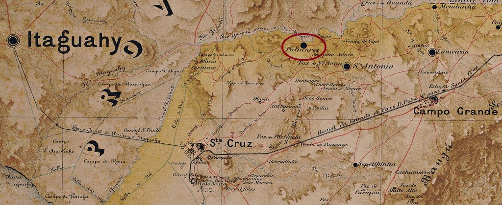
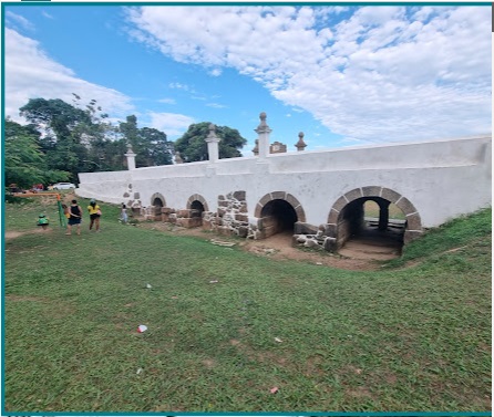
This village was located in the Freguesia de Campo Grande on the south bank of the Guandu-Mirim, 60 kilometres west of the Brazilian capital Rio de Janeiro. It was known for agriculture and small craft businesses, but has now disappeared from the map. Only the Jesuit Bridge (Ponte dos Jesuítas) from 1752 has been preserved.
Photo: Geraldo Paixão, on Google Maps, November 2022
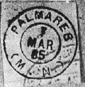
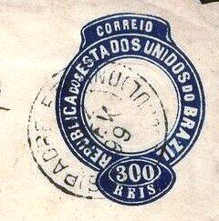
As R. Koester writes in Carimbologia XXIX, the local post office was created in April 1884. According to Paulo Novaes (agenciaspostais.com.br), it was closed in June 1918. The imperial postmark is PMN-0150a (fig. Koester, op. cit.):
PMN-0150a (RK) 1885Mappa do Districto Federal, 1920 (em agenciaspostais.com.br)
Esta localidade ficava na Freguesia de Campo Grande, na margem sul do Guandu-Mirim, 60 quilômetros a oeste da capital brasileira, Rio de Janeiro. Era conhecida pela agricultura e pequenas oficinas de artesanato, mas hoje desapareceu do mapa. Apenas a Ponte dos Jesuítas, de 1752, foi preservada.
Foto: Geraldo Paixão, no Google Maps, novembro de 2022
Como escreve R. Koester em Carimbologia XXIX, em abril de 1884 foi decidida a criação de uma agência postal local. De acordo com Paulo Novaes (agenciaspostais.com.br), esta foi fechada em junho de 1918. O carimbo postal imperial é PMN-0150a (fig. Koester, op.cit.):
PMN-0150a (RK) 1885
Diese Ortschaft lag in der Freguesia de Campo Grande am Südufer des Guandu-Mirim, 60 Kilometer westlich der brasilianischen Hauptstadt Rio de Janeiro. Sie wurde durch Landwirtschaft und kleine Handwerksbetriebe bekannt, ist heute jedoch von der Karte verschwunden. Lediglich die Jesuitenbrücke (Ponte dos Jesuítas) aus dem Jahr 1752 ist erhalten geblieben.
Foto: Geraldo Paixão, auf Google Maps, November 2022
Wie R. Koester in Carimbologia XXIX schreibt, wurde im April 1884 die Einrichtung eines örtlichen Postamts beschlossen. Dieses wurde laut Paulo Novaes (agenciaspostais.com.br) im Juni 1918 geschlossen. Der kaiserliche Poststempel ist PMN-0150a (Abb. Koester, op.cit.):
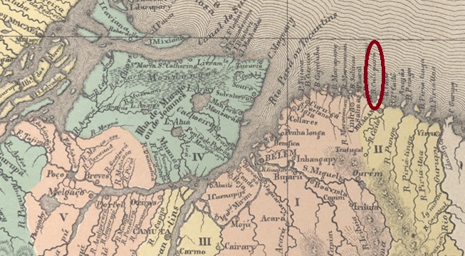
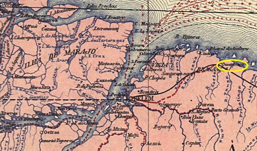
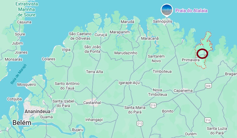
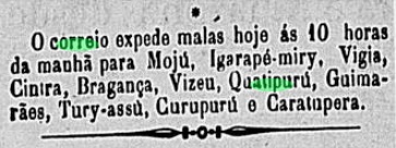
From October 1868, this settlement was known as Freguesia de Nossa Senhora de Nazareth de Quatipuru and belonged to Vila de Bragança. It was located on the north bank of the Tracauteua River, 215 km northeast of the provincial capital Belém do Pará. In July 1879, it became a Vila, but lost this status in April 1900 when it was downgraded to the Distrito of Bragança. In October 1902, it was once again promoted to a vila. Quatipuru then changed district jurisdiction several times: in September 1908, it belonged to the município de Mirasselvas, in November 1919 to Capanema, in December 1930 to Siqueira Campos, in March 1938 once again to Capanema and in December 1961 to Primavera. Since October 1994, Quatipuru has once again been an independent municipality.
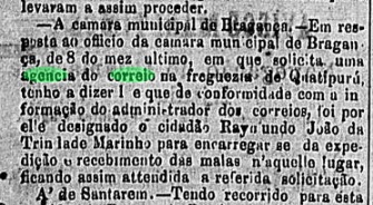
According to the regional press, there should have been a post office there since June 1880:
O Liberal do Pará, 4 June 1880
There is no evidence that the agency actually began operations, although postal traffic to the area still existed in October 1888.
Diario de Belem, 6 October 1888
No imperial postmark from Quatipuru has been seen to date.
Carta da Republica dos Estados Unidos do Brazil, 1892
A partir de outubro de 1868, essa localidade passou a ser a Freguesia de Nossa Senhora de Nazareth de Quatipuru e pertencia à Vila de Bragança. Situava-se na margem norte do rio Tracauteua, 215 km a nordeste da capital do estado, Belém do Pará. Em julho de 1879, tornou-se vila, mas perdeu esse status em abril de 1900, quando foi rebaixada a distrito de Bragança. Em outubro de 1902, voltou a ser elevada à categoria de vila. Depois disso, Quatipuru mudou várias vezes de jurisdição distrital: em setembro de 1908, pertencia ao município de Mirasselvas; em novembro de 1919, a Capanema; em dezembro de 1930, a Siqueira Campos; em março de 1938, novamente a Capanema; e, em dezembro de 1961, a Primavera. Desde outubro de 1994, Quatipuru é novamente um município independente.
Segundo a imprensa regional, deveria haver uma agência dos correios no local desde junho de 1880:
O Liberal do Pará, 04.06.1880
Não há registros de que a agência tenha realmente entrado em operação, embora em outubro de 1888 ainda houvesse correspondência postal para o local.
Até o momento, nenhum carimbo postal imperial de Quatipuru foi encontrado.
Google Maps
Diese Ortschaft war ab Oktober 1868 die Freguesia de Nossa Senhora de Nazareth de Quatipuru und gehörte zur Vila de Bragança. Sie lag am Nordufer des Tracauteua, 215 km nordöstlich der Provinzhauptstadt Belém do Pará. Im Juli 1879 wurde sie zur Vila, verlor diesen Status jedoch im April 1900, als sie zum Distrito von Bragança herabgestuft wurde. Im Oktober 1902 erfolgte erneut der Aufstieg zur Vila. Danach wechselte Quatipuru mehrmals die Zuständigkeit als Distrito: Im September 1908 gehörte sie zum Município de Mirasselvas, im November 1919 zu Capanema, im Dezember 1930 zu Siqueira Campos, im März 1938 erneut zu Capanema und im Dezember 1961 zu Primavera. Seit Oktober 1994 ist Quatipuru wieder ein eigenständiger Município.
Wie aus der regionalen Presse hervorgeht, sollte es dort seit Juni 1880 ein Postamt geben:
O Liberal do Pará, 04.06.1880
Ob die Agentur ihren Betrieb tatsächlich aufnahm, ist nicht belegt, wenngleich im Oktober 1888 noch Postverkehr dorthin bestand.
Diario de Belem, 06.10.1888
Bisher wurde kein kaiserlicher Poststempel aus Quatipuru gesehen.
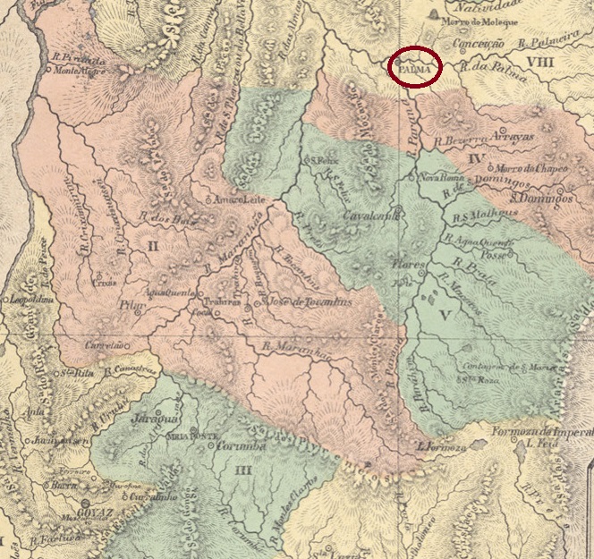
Antonio Teixeira Neto: Capitania de Goiás em 1809 (2001)
Other names: Paranã (1943)
This town at the mouth of the Rio Palma into the Paranã (a tributary of the Tocantins) was located 570 kilometres north of the provincial capital Goiás (now Goiás Velho) and became Vila de São João da Palma in February 1814. In July 1835, it became a parish. In October 1857, it was elevated to city status. Since December 1943, it has been called Paranã and has belonged to the state of Tocantins since 1988.
Two dates have been found for the establishment of the local post office. One is March 1829, as Nova Monteiro writes in Administrações e Agencias Postaes do Brasil Imperio (Brasil Filatelico/RJ, 1934–1935; reprinted by SPP 1994–1999). The other is 1832, as stated in the directory of imperial post offices (Tabella das Agencias do Correio do Imperio, Rio de Janeiro, 1885).
No imperial postmark from Palma in the province of Goiás has been found to date.
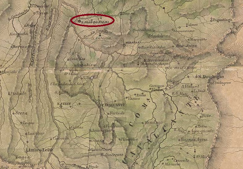
Villiers de l’Ile Adam: Carta (…) da Capitania de Goyaz (1849)
Outros nomes: Paranã (1943)
Esta localidade, situada na foz do rio Palma no Paranã (um afluente do Tocantins), ficava a 570 quilômetros ao norte da capital do estado, Goiás (hoje Goiás Velho), e tornou-se Vila de São João da Palma em fevereiro de 1814. Em julho de 1835, tornou-se freguesia. Em outubro de 1857, foi elevada à categoria de cidade, que desde dezembro de 1943 se chama Paranã e, desde 1988, pertence ao estado do Tocantins.
Foram encontradas duas datas de fundação para a agência postal local. A primeira é março de 1829, conforme escreve Nova Monteiro em Administrações e Agencias Postaes do Brasil Imperio (Brasil Filatelico/RJ, 1934–1935; reimpressão SPP 1994–1999). Outra data é 1832, conforme consta na Tabella das Agências do Correio do Império (Rio de Janeiro, 1885).
Até o momento, não foi encontrado nenhum carimbo postal imperial de Palma, na província de Goiás.
Atlas do Imperio do Brasil , 1868
Andere Namen: Paranã (1943)
Diese Ortschaft an der Mündung des Rio Palma in den Paranã (ein Zufluss des Tocantins) lag 570 Kilometer nördlich der Provinzhauptstadt Goiás (heute Goiás Velho) und wurde im Februar 1814 zur Vila de São João da Palma. Im Juli 1835 wurde sie zur Freguesia. Im Oktober 1857 erfolgte der Aufstieg zur Stadt, die seit Dezember 1943 Paranã heißt und seit 1988 zum Bundesstaat Tocantins gehört.
Es wurden zwei Entstehungsdaten für das örtliche Postamt gefunden. Zum einen im März 1829, wie Nova Monteiro in Administrações e Agencias Postaes do Brasil Imperio (Brasil Filatelico/RJ, 1934–1935; Nachdruck SPP 1994–1999) schreibt. Ein weiteres Mal im Jahr 1832, wie aus dem Verzeichnis der kaiserlichen Postämter (Tabella das Agencias do Correio do Imperio, Rio de Janeiro, 1885) hervorgeht.
Bisher wurde kein kaiserlicher Poststempel aus Palma in der Provinz Goiás gefunden.
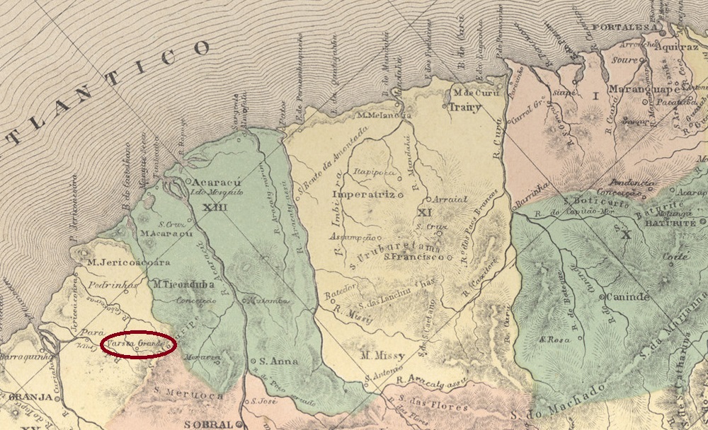
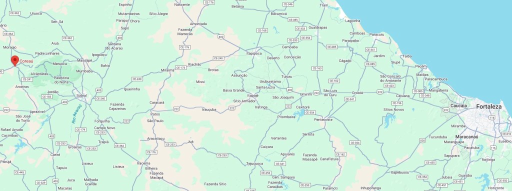
The Freguesia de N. Sra. da Piedade de Varzea Grande existed since August 1867. It belonged to the Vila de Granja, was located on the east bank of the Coreaú, 300 km east of the provincial capital Fortaleza. In September 1870, it was elevated to the status of Vila de Palma, but lost this status in October 1920 when it was once again subordinated as a district of Granja. In September 1935, it was once again elevated to the status of Município de Palmas, which has been called Município de Coreaú since December 1943.
As R. Koester writes in Carimbologia XXIX, the local post office was established in June 1871; however, no imperial postmark from Palma in the province of Ceará has been found to date.
Sociedade Geologica e Mineralogica, 1910
Outros nomes: Varzea Grande, Coreaú (1943)
A Freguesia de N. Sra. da Piedade de Varzea Grande existia desde agosto de 1867. Pertencia à Vila de Granja, ficava na margem leste do Coreaú e distava 300 km a leste da capital do estado, Fortaleza. Em setembro de 1870, foi elevada à categoria de Vila de Palma, mas perdeu esse status em outubro de 1920, quando voltou a ser subordinada como distrito de Granja. Em setembro de 1935, foi novamente elevada à categoria de Município de Palmas, que desde dezembro de 1943 se chama Município de Coreaú.
Como escreve R. Koester em Carimbologia XXIX, a agência dos correios local foi criada em junho de 1871; até o momento, porém, nenhum carimbo postal imperial de Palma, na província do Ceará, foi encontrado.
Google Maps
Andere Namen: Varzea Grande, Coreaú (1943)
Die Freguesia de N. Sra. da Piedade de Varzea Grande bestand seit August 1867. Sie gehörte zur Vila de Granja, lag am Ostufer des Coreaú und war 300 km östlich der Provinzhauptstadt Fortaleza entfernt. Im September 1870 wurde sie zur Vila de Palma erhoben, verlor jedoch diesen Status im Oktober 1920, als sie erneut als Distrikt Granja untergeordnet wurde. Im September 1935 erfolgte erneut die Erhebung zum Município de Palmas, der seit Dezember 1943 Município de Coreaú heißt.
Wie R. Koester in Carimbologia XXIX schreibt, entstand das örtliche Postamt im Juni 1871; bisher wurde jedoch kein kaiserlicher Poststempel aus Palma in der Provinz Ceará gefunden.
Carta da Republica dos Estados Unidos do Brazil, 1892
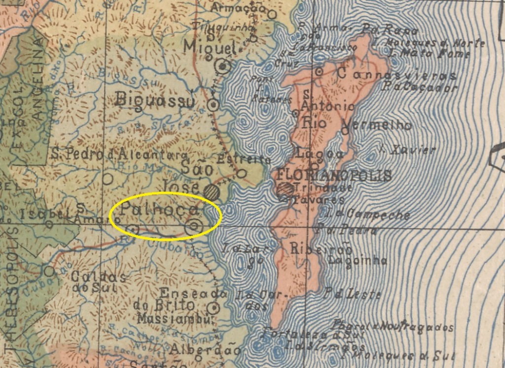
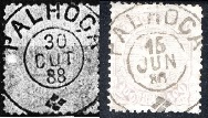
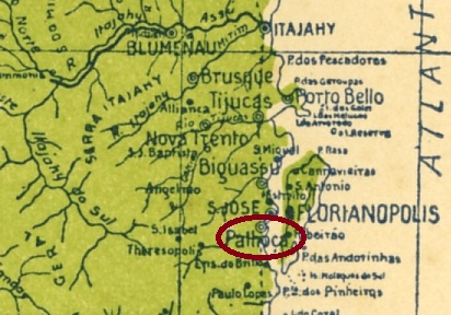
The Freguesia de Senhor Bom Jesus de Nazaré da Palhoça was founded in November 1882 and belonged to the Vila de São José. It was located on the north bank of the Cubatão, 25 kilometres southwest of the provincial capital Desterro (today Florianópolis). In April 1894, it became a vila and in August 1919 a city.
As R. Koester writes in Carimbologia XXIX, the establishment of a local post office was decided in June 1881. The oldest postmark to date is PSC-0180a, here in examples by Koester (op. cit.) and Felipe Piccinini:
PSC-0180a (RK-FP) 1886-1908Estado de Santa Catharina, 1907
A Freguesia de Senhor Bom Jesus de Nazaré da Palhoça foi fundada em novembro de 1882 e pertencia à Vila de São José. Situava-se na margem norte do Cubatão, 25 quilômetros a sudoeste da capital provincial Desterro (hoje Florianópolis). Em abril de 1894, tornou-se vila e, em agosto de 1919, cidade.
Como escreve R. Koester em Carimbologia XXIX, em junho de 1881 foi criada a agência postal local. O carimbo postal mais antigo até agora é o PSC-0180a, aqui em exemplos de Koester (op. cit.) e Felipe Piccinini:
PSC-0180a (RK-FP) 1886-1908Arthur D. Ribeiro: Estado de Santa Catharina, 1923
Die Freguesia de Senhor Bom Jesus de Nazaré da Palhoça wurde im November 1882 gegründet und gehörte zur Vila de São José. Sie lag am Nordufer des Cubatão, 25 Kilometer südwestlich der Provinzhauptstadt Desterro (heute Florianópolis). Im April 1894 wurde sie zur Vila und im August 1919 zur Stadt.
Wie R. Koester in Carimbologia XXIX schreibt, wurde im Juni 1881 die Einrichtung eines örtlichen Postamts beschlossen. Der bisher älteste Poststempel ist PSC-0180a, siehe Beispiele von Koester (op. cit.) und Felipe Piccinini:
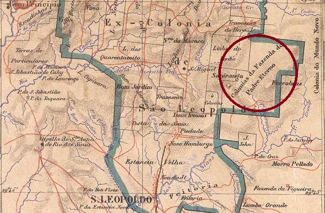
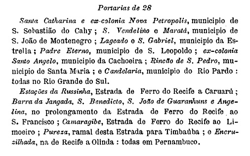
Other names: Boa Vista do Herval, Sta. Maria do Herval (1950)
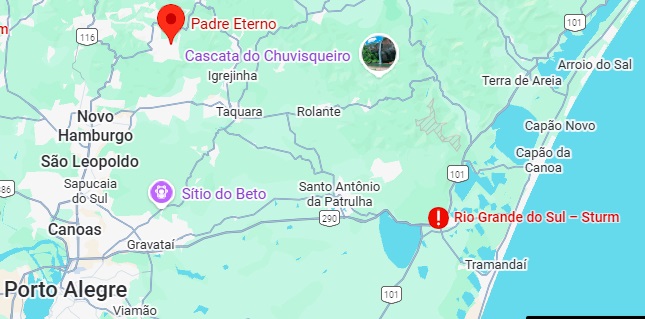
This settlement was established in the 19th century in the area of Vila de São Leopoldo, 85 km north of the provincial capital Porto Alegre. In October 1912, it was assigned to the District of Boa Vista do Herval. This district was renamed Padre Eterno in March 1938 and Santa Maria do Herval in May 1950. As all three localities are close to each other, the district seat was probably moved each time. Santa Maria do Herval became a district in the newly founded Município de Dois Irmãos in September 1959 and an independent município in May 1988, of which Padre Eterno is now a district.
According to the Postal Bulletin (Boletim Postal), the establishment of a local post office was decided in October 1889, just three weeks before the end of the Empire.
Boletim Postal No. 7, November 1889
The oldest postmark to date is PRS-0640a (image from the internet):
PRS-0640a (EB) 1899Estado do Rio Grande do Sul, 1924
Outros nomes: Boa Vista do Herval, Sta. Maria do Herval (1950)
Este povoado surgiu no século XIX na região da Vila de São Leopoldo, 85 km ao norte da capital do estado, Porto Alegre. Em outubro de 1912, foi incorporado ao Distrito de Boa Vista do Herval. Este distrito foi renomeado Padre Eterno em março de 1938 e Santa Maria do Herval em maio de 1950. Como as três localidades são vizinhas, presume-se que a sede distrital tenha sido transferida entre elas ao longo do tempo. Santa Maria do Herval tornou-se um distrito do recém-criado Município de Dois Irmãos em setembro de 1959 e, em maio de 1988, um município independente, do qual Padre Eterno agora é um bairro.
Conforme consta no Boletim Postal, em outubro de 1889, poucas semanas antes do fim do Império, foi criada uma agência dos correios no local.
Boletim Postal nº 7, novembro de 1889
O carimbo postal mais antigo até o momento é o PRS-0640a (figura da internet):
PRS-0640a (EB) 1899Google Maps
Andere Namen: Boa Vista do Herval, Sta. Maria do Herval (1950)
Diese Siedlung entstand im 19. Jahrhundert im Gebiet der Vila de São Leopoldo, 85 km nördlich der Provinzhauptstadt Porto Alegre. Im Oktober 1912 wurde sie dem Distrito de Boa Vista do Herval zugeordnet. Dieser Distrikt wurde im März 1938 in Padre Eterno und im Mai 1950 in Santa Maria do Herval umbenannt. Da alle drei Gemeinden nah beieinander liegen, wurde der Sitz vermutlich jeweils verlegt. Santa Maria do Herval wurde im September 1959 ein Distrikt im neu gegründeten Município de Dois Irmãos und im Mai 1988 ein eigenständiger Município, von dem Padre Eterno nun ein Ortsteil ist.
Wie aus dem Postbulletin (Boletim Postal) hervorgeht, wurde im Oktober 1889, knapp drei Wochen vor dem Ende des Kaiserreichs, die Einrichtung eines Postamts vor Ort beschlossen.
Boletim Postal Nr. 7, November 1889
Der bisher älteste Poststempel ist PRS-0640a (Abb. aus dem Internet):
Villiers de l’Ile Adam: Carta (…) da Provincia do Maranhão, 1850
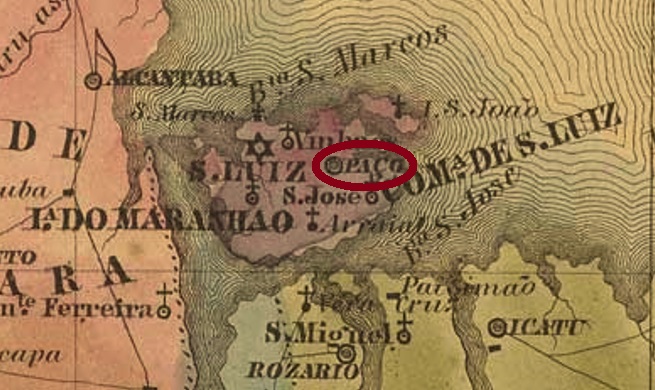
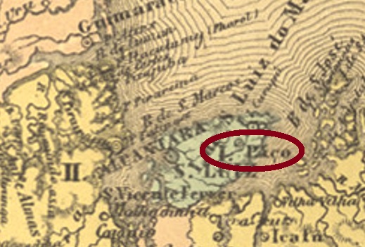
See also Vila do Paço (VMA-0295)
The freguesia of Paço do Lumiar originated as early as June 1757 and belonged to the vila of São Luiz do Maranhão, 13 km away. The village is said to have been promoted to vila twice, in June 1761 and in April 1835. It was not until the 20th century, in February 1931, that it was relegated as a district of São Luís, then 12 years later it changed to the município of Ribamar. Since December 1959, it has been the município of Paço do Lumiar.
As can be read in the postal report (Relatorio Postal) from 1886, there was a post office there since February 1875. So far, no imperial postmark has been found from this locality.
Atlas do Imperio do Brasil, 1868
Ver também Vila do Paço (VMA-0295)
A freguesia do Paço do Lumiar teve origem já em junho de 1757 e pertencia à vila de São Luiz do Maranhão, estando a 13 km de distância ao leste desta. Diz-se que a localidade foi promovida a vila duas vezes, em junho de 1761 e em abril de 1835. Foi só no século XX, em fevereiro de 1931, que foi rebaixada como um distrito de São Luís, e 12 anos depois mudou para o município de Ribamar. Desde dezembro de 1959, é o município de Paço do Lumiar.
Como pode ser lido no Relatorio Postal de 1886, desde fevereiro de 1875 havia ali uma agência de correios. Até agora, não foi encontrado nenhum carimbo postal imperial desta localidade.
Carta da Republica dos Estados Unidos do Brazil, 1892
Siehe auch Vila do Paço (VMA-0295)
Die Freguesia von Paço do Lumiar entstand bereits im Juni 1757 und gehörte der 13 km weit entfernte Vila von São Luiz do Maranhão. Der Ort soll zweimal zur Vila aufgestiegen sein, im Juni 1761 und im April 1835. Erst im 20. Jahrhundert, im Februar 1931, erfolgte der Abstieg als Distrikt von São Luís, dann 12 Jahre später wechselte der Ort zum município von Ribamar. Seit Dezember 1959 ist es der município von Paço do Lumiar.
Wie im Postbericht (Relatorio Postal) aus 1886 zu lesen ist, gab es dort ein Postamt seit Februar 1875. Bisher wurde kein Poststempel aus der Kaiserzeit aus dieser Gemeinde gefunden.
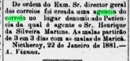
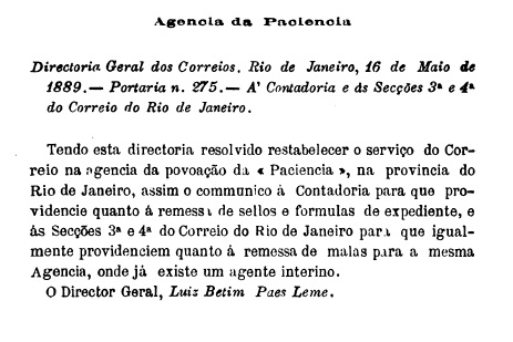
It is not known exactly when this settlement, located 30 kilometres east of the capital Rio de Janeiro, was founded. It may have originated from a fazenda, originally belonging to the município de Niterói and, from September 1890, also to the vila de S. Gonçalo. Today, it is believed to be the district of Maria Paula, which is located partly in Niterói and partly in São Gonçalo.
The directory of imperial post offices (Tabella das Agencias do Correio do Imperio, Rio de Janeiro, 1885) shows that there has been a post office there since 1880. This is confirmed by the Rio press.
O Fluminense, 02.02.1881
The agency must have been closed later, as its reopening in 1889 was announced in the Postal Bulletin (Boletim Postal).
Boletim Postal, 1889
No imperial postmark from this location has been found to date.
agenciaspostais.com.br
Outros nomes: Maria Paula
Não se sabe ao certo quando surgiu este povoado, localizado 30 quilômetros a leste da capital Rio de Janeiro. Ele pode ter se originado de uma fazenda, pertencendo originalmente ao município de Niterói e, a partir de setembro de 1890, também à Vila de S. Gonçalo. Hoje, acredita-se que se trate do bairro Maria Paula, que fica parcialmente em Niterói e parcialmente em São Gonçalo.
A Tabella das Agencias do Correio do Império (Rio de Janeiro, 1885) indica que havia uma agência postal no local desde 1880. Isso é confirmado pela imprensa do Rio.
O Fluminense, 02/02/1881
A agência deve ter sido fechada posteriormente, pois sua reabertura em 1889 foi anunciada no Boletim Postal.
Boletim Postal, 1889
Até o momento, nenhum carimbo postal imperial desse local foi encontrado.
Google Maps
Andere Namen: Maria Paula
Wann genau diese Siedlung, die 30 Kilometer östlich der Hauptstadt Rio de Janeiro lag, entstanden ist, ist nicht überliefert. Sie könnte aus einer Fazenda stammen, gehörte ursprünglich zum Município de Niterói und ab September 1890 auch zur Vila de S. Gonçalo. Heute soll es sich dabei um den Stadtteil Maria Paula handeln, der teilweise sowohl in Niterói als auch in São Gonçalo liegt.
Aus dem Verzeichnis der kaiserlichen Postämter (Tabella das Agencias do Correio do Imperio, Rio de Janeiro, 1885) geht hervor, dass es dort seit 1880 ein Postamt gab. Dies wird durch die Rio Presse bestätigt.
O Fluminense, 02.02.1881
Die Agentur muss später geschlossen worden sein, da eine Wiedereröffnung im Jahr 1889 im Postbulletin (Boletim Postal) bekannt gegeben wurde.
Boletim Postal, 1889
Bisher wurde kein kaiserlicher Poststempel aus diesem Ort gefunden.
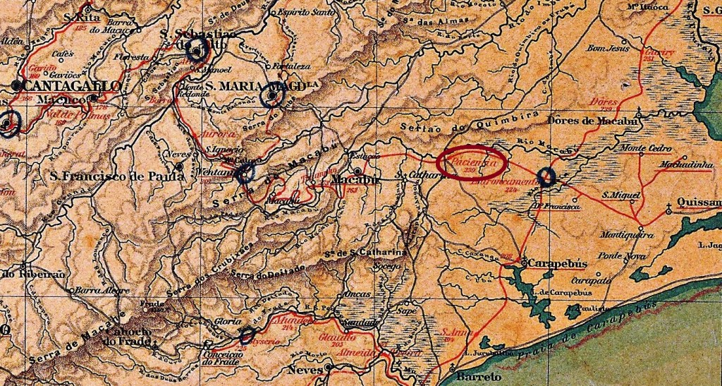
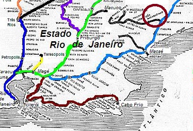
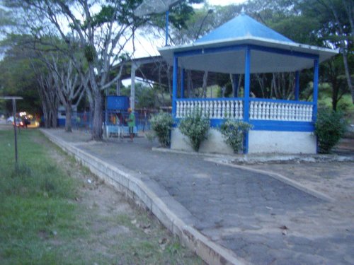
The Paciencia (Patience) railway station was opened in January 1879 by the E.F. Barão de Araruama railway company on the Sta. Maria Magdalena line. It was located near the south bank of the Macabu River in the municipality of Macaé, 220 kilometres northeast of the capital Rio de Janeiro. The railway line was transferred to E.F. Leopoldina in 1890 and closed in 1966. Neither the tracks nor the station building remain today (estacoesferroviarias.com.br).
Around 1930, the station in the background (photo: estacoesferroviarias.com.br)In 2009 (photo: Ricardo Quintero de Matos, estacoesferroviarias.com.br)
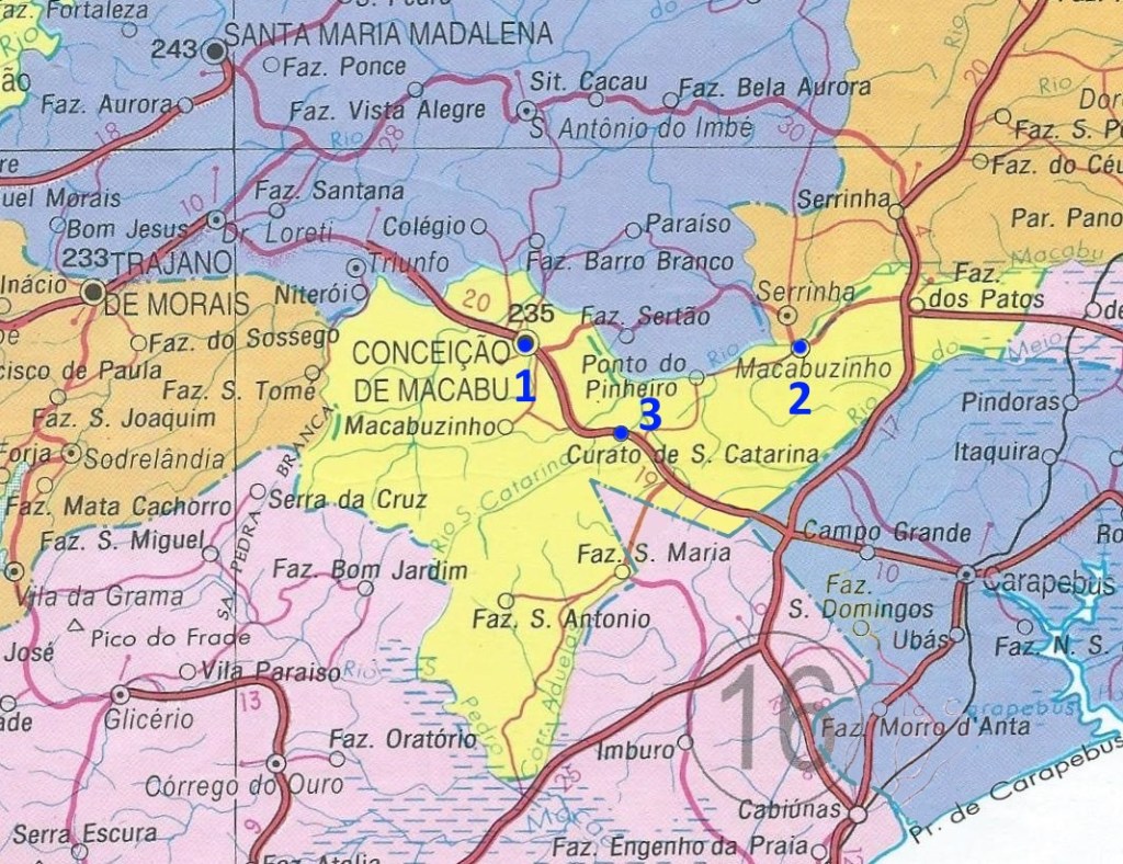
In January 1931, the area around the station became part of the newly founded district of Sant’Ana da Paciencia do Macabu. Seven years later, this was renamed Macabuzinho. Later, the station also took on the name of the locality. From March 1952, the station was located in the município de Conceição de Macabu.
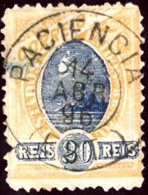
The directory of imperial post offices (Tabella das Agencias do Correio do Imperio, Rio de Janeiro, 1885) shows that there was a post office at the station from 1880, which was closed around 1940 (agenciaspostais.com.br).
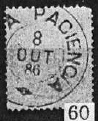
The oldest postmark to date is PRJ-2475a (Fig. Koester, op. cit.):
PRJ-2475a (RK) 1886
This was followed by PRJ-2475b (Márcio Protzner collection):
PRJ-2475b (MP) 1896-1904Estrada de Ferro Leopoldina
Outros nomes: Macabuzinho (1940)
Veja também Paciência (PRJ-2476)
A estação Paciência foi inaugurada em janeiro de 1879 pela E.F. Barão de Araruama, Ramal de Sta. Maria Madalena. Ela ficava próxima à margem sul do rio Macabu, no município de Macaé, 220 quilômetros a nordeste da capital Rio de Janeiro. A linha férrea passou para a E.F. Leopoldina em 1890 e foi desativada por volta de 1966. Nem os trilhos nem o prédio da estação foram preservados até hoje (estacoesferroviarias.com.br).
Por volta de 1930, a estação ao fundo (Foto: estacoesferroviarias.com.br)Em 2009 (Foto: Ricardo Quintero de Matos, estacoesferroviarias.com.br)
A área ao redor da estação ferroviária passou a fazer parte, em janeiro de 1931, do recém-criado distrito de Sant’Ana da Paciência do Macabu. Sete anos depois, este foi renomeado para Macabuzinho. Mais tarde, a estação ferroviária também assumiu o nome do local. A partir de março de 1952, a estação ferroviária passou a pertencer ao município de Conceição de Macabu.
A Tabella das Agencias do Correio do Império (Rio de Janeiro, 1885) indica que havia uma agência dos correios na estação desde 1880, que foi fechada por volta de 1940 (agenciaspostais.com.br).
O carimbo postal mais antigo até agora é o PRJ-2475a (fig. Koester, op. cit.):
PRJ-2475a (RK) 1886
Depois veio o PRJ-2475b (coleção Márcio Protzner):
PRJ-2475b (MP) 1896-1904agenciaspostais.com.br
Andere Namen: Macabuzinho (1940)
Siehe auch Paciencia (PRJ-2476)
Der Bahnhof Paciencia (Geduld) wurde im Januar 1879 von der Eisenbahngesellschaft E.F. Barão de Araruama auf der Strecke Sta. Maria Magdalena eröffnet. Er lag nahe dem Südufer des Macabu im Município de Macaé, 220 Kilometer nordöstlich der Hauptstadt Rio de Janeiro. Die Bahnlinie ging 1890 an die E.F. Leopoldina über und wurde um 1966 stillgelegt. Weder die Gleise noch das Bahnhofsgebäude sind heute erhalten (estacoesferroviarias.com.br).
Ca. 1930, der Bahnhof im Hintergrund (Foto: estacoesferroviarias.com.br)Im Jahr 2009 (Foto: Ricardo Quintero de Matos, estacoesferroviarias.com.br)
Das Gebiet um den Bahnhof wurde im Januar 1931 Teil des neu gegründeten Distrikts Sant’Ana da Paciencia do Macabu. Dieser wurde sieben Jahre später in Macabuzinho umbenannt. Später übernahm auch der Bahnhof die Ortsbezeichnung. Ab März 1952 lag der Bahnhof im Município de Conceição de Macabu.
Aus dem Verzeichnis der kaiserlichen Postämter (Tabella das Agencias do Correio do Imperio, Rio de Janeiro, 1885) geht hervor, dass es am Bahnhof seit 1880 ein Postamt gab, das um 1940 geschlossen wurde (agenciaspostais.com.br).
Der bisher älteste Poststempel ist PRJ-2475a (Abb. Koester, op. cit.):
Bellegard & Niemeyer: Carta Corographica da Provincia do Rio de Janeiro, 1867
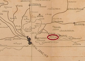
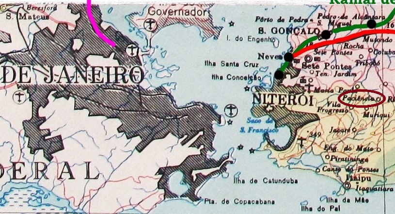
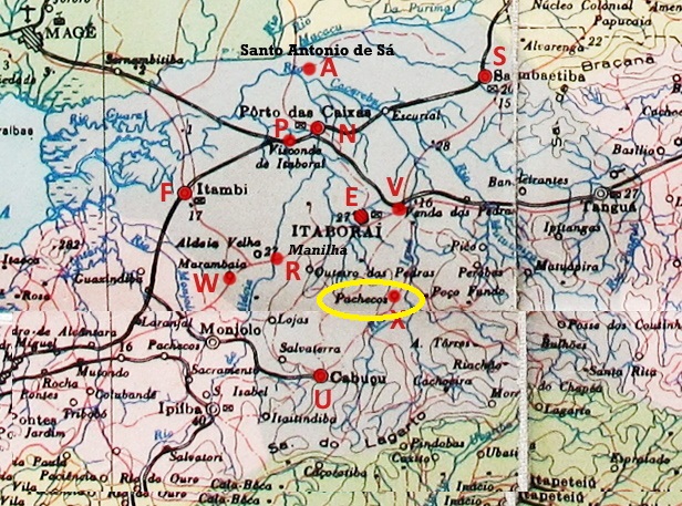
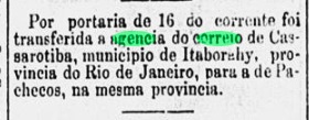
This settlement in the Vila de Itaboraí area was located 65 kilometres east of the capital Rio de Janeiro and only became a district in April 1993.
R. Koester writes in Carimbologia XXIX that the establishment of a post office was decided in June 1885. However, this agency was not operating until October of the same year, when the post office was relocated from Cassarotiba (CRJ-0330).
O Paiz, 18 October 1885
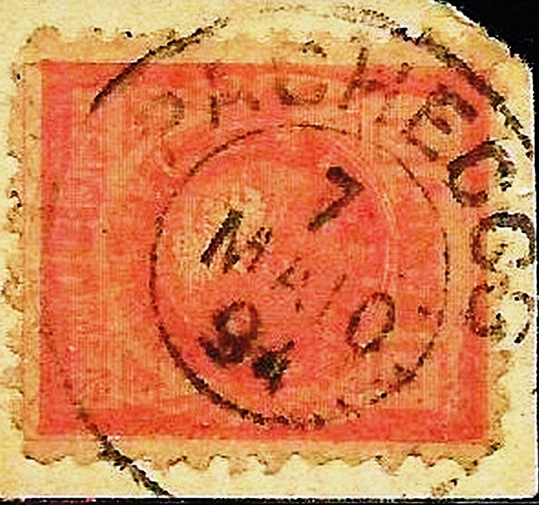
The imperial postmark is PRJ-2470a (Fig. Felipe Piccinini):
PRJ-2470a (FP) 1886-1899agenciaspostais.com.br
Este povoado, localizado na região da Vila de Itaboraí, ficava a 65 quilômetros a leste da capital Rio de Janeiro e só se tornou distrito em abril de 1993.
R. Koester escreve em Carimbologia XXIX que, em junho de 1885, foi decidida a criação de uma agência dos correios. No entanto, ela só começou a operar em outubro do mesmo ano, com a transferência da agência dos correios de Cassarotiba (CRJ-0330).
O Paiz, 18/10/1885
O carimbo postal imperial é PRJ-2470a (fig. Felipe Piccinini):
PRJ-2470a (FP) 1886-1899Google Maps
Diese Siedlung im Gebiet der Vila de Itaboraí lag 65 Kilometer östlich der Hauptstadt Rio de Janeiro und wurde erst im April 1993 zum Distrito.
R. Koester schreibt in Carimbologia XXIX, dass im Juni 1885 die Einrichtung eines Postamts beschlossen wurde. Dieses wurde jedoch erst im Oktober desselben Jahres eingerichtet, durch die Verlegung des Postamtes aus Cassarotiba (CRJ-0330).
O Paiz, 18.10.1885
Der kaiserliche Poststempel ist PRJ-2470a (Abb. Felipe Piccinini):