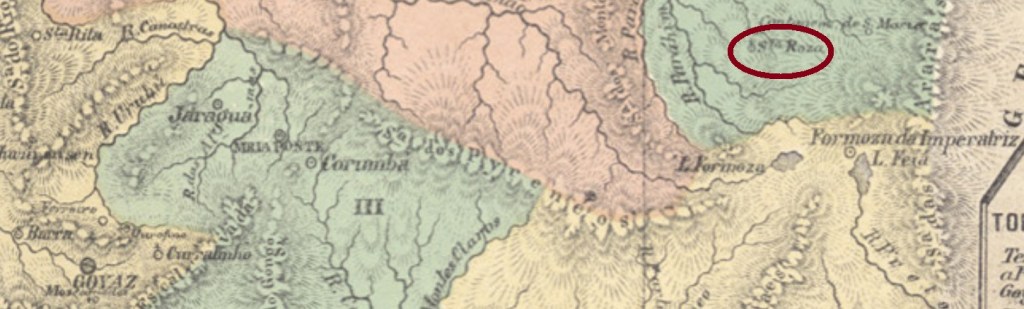
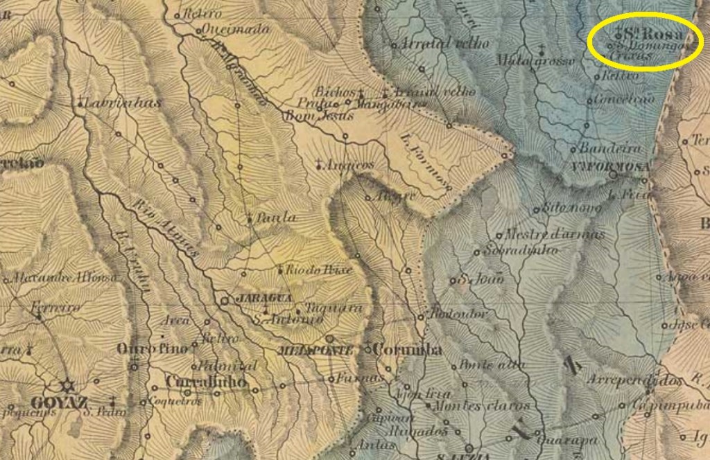
Santa Rosa in the Goyaz province is not the actual Santa Rosa de Goiás. It was since August 1843 a district in the municipality of Villa Formosa da Imperatriz, situated over 400 km east of the ancient province capital Goyaz (now Goiás Velho). Since May 1924 it integrates the municipality of Formosa.
No postal cancel from the empire has appeared until now.
Villers de l’Ile Adam: Carta (…) da Provincia de Goyaz
Santa Rosa in der Provinz Goyaz ist nicht die heutige Stadt Santa Rosa de Goiás. Es war seit August 1843 ein Distrikt im Município von Villa Formosa da Imperatriz und lag über 400 km östlich der ehemaligen Hauptstadt Goyaz (heute Goiás Velho) entfernt. Seit Mai 1924 gehört Santa Rosa zum Município von Formosa.
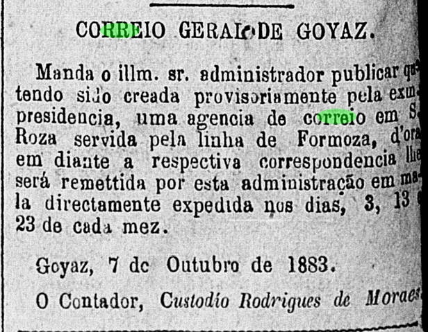
Laut Verzeichnis der kaiserlichen Postämter (Tabella das Agencias do Correio do Imperio) von 1885 gibt es ein Postamt dort seit 1883, was durch die Amtspresse der Provinz bestätigt werden kann:
Correio Official de Goyaz, 10. November 1883
Kein Poststempel aus der Kaiserzeit ist bisher in Erscheinung getreten.
Other names: Rio Preto, Ibipetuba, Santa Rita de Cássia (1972)
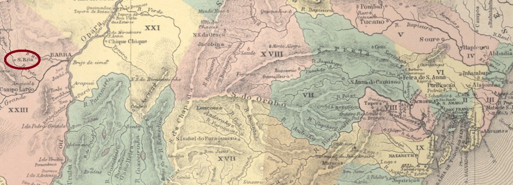
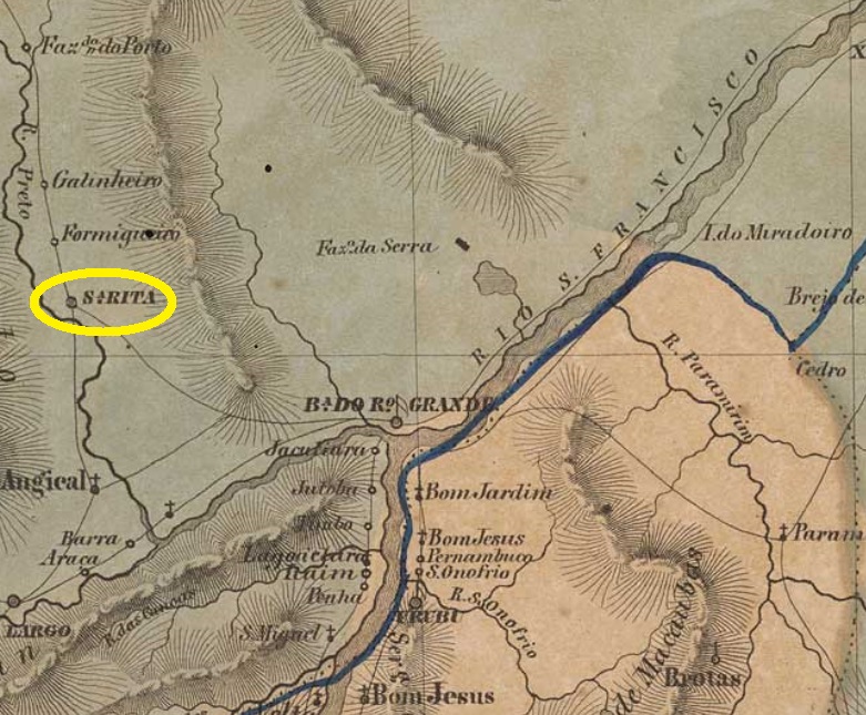
Santa Rita do Rio Preto was originally a district in the municipality of Barra do Rio Grande, situated almost 900 km west of the province capital Salvador da Bahia. In March 1840 it was elevated to a villa in own municipality. Since then it has changed the name three times: in June 1931 to Rio Preto, in December 1943 to Ibipetuba – a tupi word that means sand bank -, and in December 1972 to the actual Santa Rita de Cássia.
One early cancel was found, which is certainly not the earliest. SBA-0665b (Coll. José A. Junges) has a double circle with the inscription S. R. DO RIO PRETO, the date at the centre shows already the year 1893.
Villiers de l’Ile Adam: Carta (…) da Provincia da Bahia
Andere Namen: Rio Preto, Ibipetuba, Santa Rita de Cássia (1972)
Sant Rita do Rio Preto war ursprünglich ein Distrikt des Município von Barra do Rio Grande und lag fast 900 km westlich der Provinzhauptstadt Salvador da Bahia entfernt. Im März 1840 stieg die Ortschaft zur Villa auf und danach wechselte der Ortsname dreimal: im Juni 1931 zu Rio Preto, im Dezember 1943 zu Ibipetuba – das Tupi-Wort bedeutet Sandbank – und im Dezember 1972 zum heutigen Santa Rita de Cássia.
Laut Verzeichnis der kaiserlichen Postämter (Tabella das Agencias do Correio do Imperio) von 1885 gibt es das Postamt dort seit 1855. Da aber Nova Monteiro (Administrações e Agencias Postaes do Brasil Imperio, in Brasil Filatelico/RJ, 1934-5; Reprint SPP 1994-1999) dafür das genaue Datum 25. Januar 1856 angibt, möglicherweise wäre zum letztgenannten Termin der Betriebsstart der Agentur.
Nur ein früher Stempel wurde gefunden, der sicher nicht der älteste ist. SBA-0665b (Samml. José A. Junges) hat einen Doppelkreis mit der Inschrift S. R. DO RIO PRETO. Das Datum in der Mitte des einzigen Exemplars zeigt bereits das Jahr 1893.
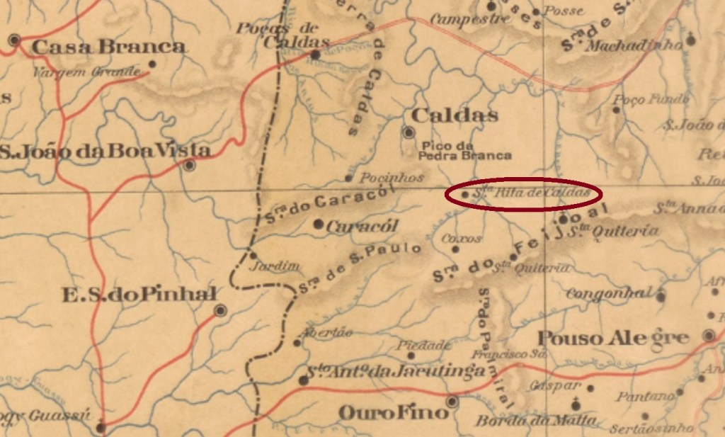
The freguesia of Santa Rita de Cássia do Rio Claro was created in July 1868 in the municipality of Rio Verde das Caldas, over 500 km southwest of the ancient province capital Ouro Preto. In October 1909 the locality changed the name to Santa Rita de Caldas, and became an own municipality in December 1943.
According to Paula Sobrinho (História Postal de Minas Gerais, Belo Horizonte, 1997), the local post office is dated May 1882. Two early cancels are known: SMG 2935a (Coll. José A. Junges) has a double circle with the inscription S. RITA DO RIO CLARO above and a cross ornament below, which consists of four twigs. The dates at the centre are from the period 1884-1887. It is followed by SMG-2935b (Coll. Dieter Kerkhoff), which is almost identical as before, but here the ornament below is a diamond, formed by four small diamonds. Dates from 1896 to 1899.
GoogleMaps
Die Freguesia von Santa Rita de Cássia do Rio Claro entstand im Juli 1868 im Município von Rio Verde das Caldas und lag über 500 km südwestlich der ehemaligen Provinzhauptstadt Ouro Preto entfernt. Im Oktober 1909 wechselte sie den Namen zu Santa Rita de Caldas und bekam einen eigenen Município im Dezember 1943.
Laut Paula Sobrinho (História Postal de Minas Gerais, Belo Horizonte, 1997) gibt es dort ein Postamt seit Mai 1882. Zwei alte Poststempel wurden gefunden: SMG 2935a (Samml. José A. Junges) hat einen Doppelkreis mit der Inschrift S. RITA DO RIO CLARO oben und einem kreuzförmigen Ornament unten, das aus vier Zweigen besteht. Die Daten in der Mitte kommen aus dem Zeitraum 1884-1887. Ihm folgte SMG-2935b (Samml. Dieter Kerkhoff), der fast identisch mit seinemVorgänger ist, doch hier ist das untere Ornament nun eine Raute, die aus vier kleinen Rauten besteht. Daten zwischen 1896 und 1899.
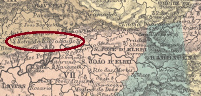
The history of Santa Rita do Rio Abaixo (Holy Rita of the Lower Course, which probably refers to the Rio das Mortes) began in April 1854, as a parish in the municipality of São José del Rey, situated over 170 km southwest of the province capital Ouro Preto. It changed the name to Ibitutinga in September 1923, to recover the old toponym in December 1938. Since December 1962 it is the municipality of Ritápolis.
According to Paula Sobrinho (História Postal de Minas Gerais, Belo Horizonte, 1997), the local post office was created in October 1885. One early cancel was found : SMG-2930a (Coll. FM) also occurs in blue and has a double circle with the inscription S. RITA DO RIO ABAIXO above and a still undefined ornament below. The dates at the centre come from the period 1890-1896.
Mappa das Provincias de Minas Geraes e Espírito Santo, 1873
Die Geschichte von Santa Rita do Rio Abaixo (Heilige Rita am Unterlauf, gemeint ist wahrscheinlich der Rio das Mortes) startete im April 1854, als die Pfarrei im Município von São José del Rey gegründet wurde, ca. 170 km südwestlich der alten Provinzhauptstadt Ouro Preto entfernt. Der alte Ortsname wechselte zu Ibitutinga im September 1923, kehrte aber im Dezember 1938 zurück. Seit Dezember 1962 ist es der Município von Ritápolis.
Laut Paula Sobrinho (História Postal de Minas Gerais, Belo Horizonte, 1997) gibt es ein Postamt dort seit Oktober 1885. Ein früher Stempel ist aufgetaucht : SMG-2930a (Samml. FM) kommt auch in blau vor und hat einen Doppelkreis mit der Inschrift S. RITA DO RIO ABAIXO oben und einem bisher undefinierbaren Ornament unten. Die Daten in der Mitte weisen auf den Zeitraum 1890-1896 auf.
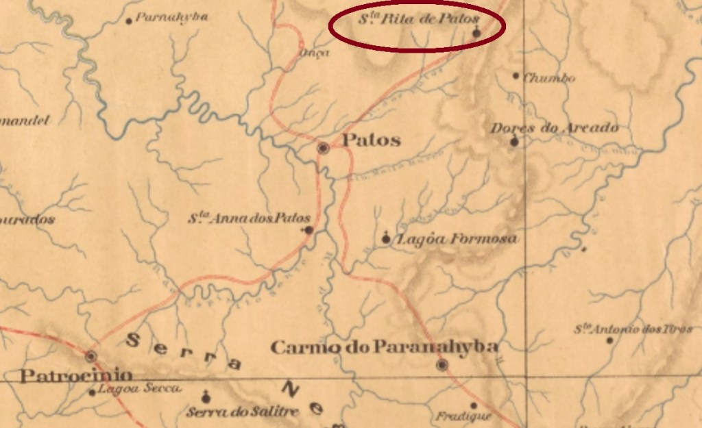
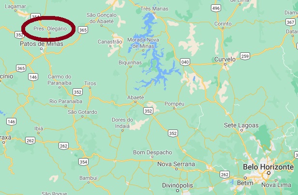
Santa Rita de Patos was since November 1880 a district of the municipality of Patos, situated over 500 km northwest of the ancient province capital Ouro Preto. In December 1938 it emancipated politically, becoming the municipality of Presidente Olegário. The actual name is a tribute to Olegário Dias Maciel (1855-1933) who twice presided over the state Minas Gerais: in 1924 and 1930-1933.
According to Paula Sobrinho (História Postal de Minas Gerais, Belo Horizonte, 1997), the local post office was created in July 1882. No imperial post cancel has appeared until now.
GoogleMaps
Santa Rita de Patos war seit November 1880 ein Distrikt des Município von Patos und lag über 500 km nordwestlich der ehemaligen Provinzhauptstadt Ouro Preto entfernt. Im Dezember 1938 wurde daraus der Município von Presidente Olegário. Der Name ist eine Hommage an Olegário Dias Maciel (1855-1933), der zweimal Präsident des Staates Minas Gerais war: in 1924 und zwischen 1930 und 1933.
Laut Paula Sobrinho (História Postal de Minas Gerais, Belo Horizonte, 1997) entstand das örtliche Postamt im Juli 1882. Kein Poststempel der Kaiserzeit wurde bisher gefunden.
See also Passa Quatro/SP (R. Koester: Carimbologia XXX)
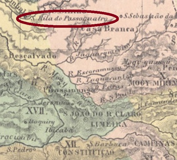
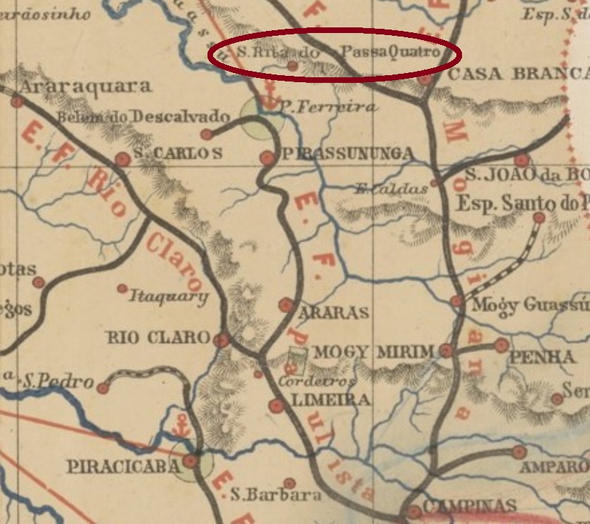
Santa Rita de Cássia do Passa Quatro was since April 1866 a district of the municipality of Belém do Descalvado, situated over 250 km north of the province capital São Paulo. The name Passa Quatro means Fourfold Pass and refers to a brook of the surroundings that had four pass spots to cross over. The Santa Rita district changed twice the municipality: in April 1870 to Casa Branca and in July 1875 to Pirassununga. In March 1885 it was elevated to a villa, which became a town in September 1894.
According to the Imperial Mail Register (Tabella das Agencias do Correio do Imperio) of 1885, the local post office was created in 1870. However, it is listed under Passa Quatro, which seems to be the more common toponym at that time. Later in the Republic the name Santa Rita reappeared on local cancels. SSP-1690a (image from the internet) is until now the only cancellation featuring the full name S. R. DO PASSA QUATRO in a double circle. The known copy of it is centrally dated 1877.
For cancels featuring solely PASSA QUATRO see R. Koester’s Carimbologia XXX.
Mappa da Provincia de São Paulo, 1886
Anderer Name: Santa Rita (1938-1944)
Siehe auch Passa Quatro/SP (R. Koester: Carimbologia XXX)
Santa Rita de Cássia do Passa Quatro war seit April 1866 ein Distrikt im Município von Belém do Descalvado und lag über 250 km nördlich der Provinzhauptstadt São Paulo entfernt. Der Name Passa Quatro bedeutet Vierfacher Pass und bezieht sich zu einem kleinen Fluss der Umgebung, der vier Überquerungsstellen hatte. Der Distrikt wechselte seine Zuständigkeit zweimal: im April 1870 zu Casa Branca und im Juli 1875 zu Pirassununga. Im März 1885 wurde daraus eine Villa, die im September 1894 zur Stadt aufstieg.
Das Verzeichnis der kaiserlichen Postämter (Tabella das Agencias do Correio do Imperio) von 1885 listet das örtliche Postamt ab 1870, allerdings unter Passa Quatro, der in der Zeit der gebräuchliche Ortsname gewesen zu sein scheint. Erst in der Republik kehrte Santa Rita auf den Ortsstempeln zurück. SSP-1690a (Abb. aus dem Internet) ist bisher die einzige Abstempelung, in der S. R. DO PASSA QUATRO im Doppelkreis zu lesen ist. Das einzig gesehene Exemplar trägt ein Datum aus 1877 in der Mitte.
Für weitere Stempel nur mit PASSA QUATRO siehe R. Koesters Carimbologia XXX.
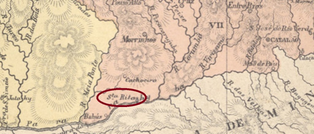
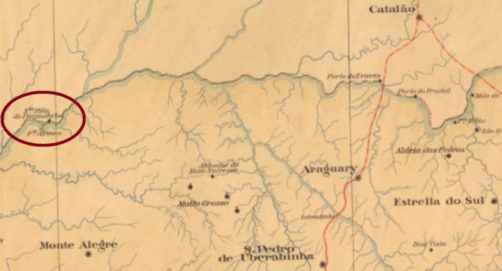
Other names: Porto de Santa Rita, Itumbiara (1943)
See also Paranahyba/GO (R. Koester: Carimbologia XXIX)
Santa Rita do Paranahyba was called formerly Porto de Santa Rita, and was situated on the west bank of the Paranahyba River, round 350 km south of the ancient province capital Goyaz (now Goiás Velho). Since August 1852 a district of the municipality of Bomfim, it ascended to a villa in July 1909 and to a city in October 1915, whose toponym changed to Itumbiara in December 1943. This tupi-guarani word means waterfall road.
Since the post office was not listed in the Postal Guide for 1880, it has been supposedly closed by 1879. No postal cancel from the Empire has come to light by now.
Mappa do Estado de Minas Geraes, 1910
Aktualisierung der Buchversion, vom 4. Mai 2021
Andere Namen: Porto de Santa Rita, Itumbiara (1943)
Siehe auch Paranahyba/GO (R. Koester: Carimbologia XXIX)
Santa Rita do Paranahyba hieß früher Porto de Santa Rita und war eine Ortschaft am Westufer des Flusses Paranahyba, rund 350 km südlich der ehemaligen Provinzhauptstadt Goyaz (heute Goiás Velho) entfernt. Seit August 1852 war sie ein Distrikt im Município von Bomfim, dann stieg sie im Juli 1909 zur Villa und im Oktober 1915 zur Stadt, die seit Dezember 1943 Itumbiara heißt. Der Begriff aus der tupi-guarani-Sprache bedeutet Weg zum Wasserfall.
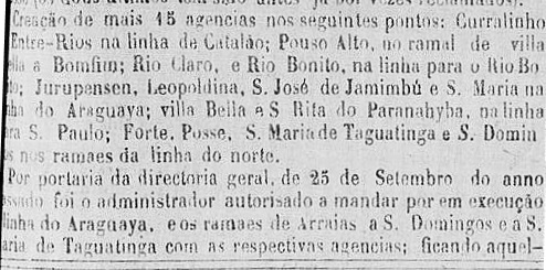
Zwei verschiedene Jahresangaben wurden für das örtliche Postamt gefunden. Laut Verzeichnis der kaiserlichen Postämter (Tabella das Agencias do Correio do Imperio) von 1885 soll es 1882 entstanden sein, doch das wäre wohl eine Wiedereröffnung, denn die Agentur wurde bereits 1875 offiziell angekündigt:
Correio Official de Goyaz, 15. September 1875
Da dieses Postamt nicht im Postführer für 1880 aufgelistet ist, wurde es vermutlich irgendwann bis 1879 geschlossen. Kein Poststempel aus der Kaiserzeit war bisher zu sehen. Für Stempel nur mit Paranahyba, siehe Koesters Carimbologia XXIX.
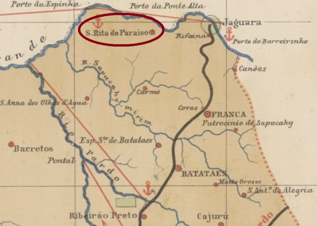
Santa Rita do Paraizo was since April 1851 a freguesia of the municipality of Franca, situated on the south bank of the Rio Grande on the northern edge of the São Paulo province, ca. 450 km away from the capital. In April 1873 it was elevated to a villa, which became a town in December 1906. Since November 1907 it is the municipality of Igarapava, a tupi-guarani word that means canoe harbor.
It was followed by SSP-1305b (image from the internet), which is a French-type: small double circle, with the inscription S. RITA DO PARAISO above and a star within brackets below. Dates in the centre found for the period 1889-1897.
Mappa da Provincia de São Paulo, 1886
Anderer Name: Igarapava (1907)
Santa Rita do Paraizo war seit April 1851 eine Freguesia im Município von Franca und lag am Südufer des Rio Grande am Nordrand der Provinz São Paulo, ca. 450 km von der Hauptstadt entfernt. Im April 1873 stieg sie zur Villa auf, die im Dezember 1906 eine Stadt wurde. Seit November 1907 ist es der Município von Igarapava, ein Begriff der tupi-guarani Sprache, der Kanuhafen bedeutet.
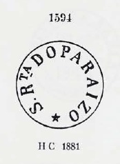
Laut Nova Monteiro (Administrações e Agencias Postaes do Brasil Imperio, in Brasil Filatelico/RJ, 1934-5; Reprint SPP 1994-1999) gibt es dort ein Postamt seit Juni 1857. Zwei Poststempel der Kaiserzeit sind überliefert. SSP-1305a hat Daten zwischen 1877 und 1888 und wurde bereits durch Paulo Ayres (Catálogo de Carimbos Brasil-Império, S. Paulo, 1937, 1942) mit Nr. 1594 vorgestellt:
SSP-1305a – P. Ayres 1594
Ihm folgte SSP-1305b (Abb. aus dem Internet): ein französischer-Typ mit kleinem Doppelkreis, dazu Inschrift S. RITA DO PARAISO oben und ein Stern zwischen Klammern unten. Die Daten in der Mitte wurden für den Zeitraum 1889-1897 gefunden.
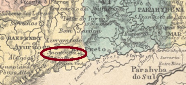
Jacutinga (white jacu, in tupi) is a bird (Pipile jacutinga, Spix, 1825) of the Cracidae family, that can reach 75 cm lenght, but it is meanwhile also endangered. Santa Rita do Jacutinga (also written Jacotinga) was since June 1859 a district of the municipality of Rio Preto, situated over 300 km south of the ancient province capital Ouro Preto. In December 1943 it emancipated politically.
According to Paula Sobrinho (História Postal de Minas Gerais, Belo Horizonte, 1997), the local post office was created in December 1873. Two early cancels are known. SMG-2915a (Coll. José A. Junges) has a double circle with the inscription S. RITA DO JACUTINGA above and a diamond ornament below, which consists of four small twigs. The dates in the centre were found for the period 1884-1886. The following SMG-2915b (Coll. José A. Junges), is similar to its predecessor, but here the inscriptions are (…) RITA DE JACOTINGA above and (MINAS) below. Dates in the centre between 1888 and 1890.
Atlas do Imperio do Brasil, 1868
Ein jacutinga (weißer Jacu, in tupi) ist ein Vogel (Pipile jacutinga, Spix, 1825) der Cracidae-Familie, der bis 75 cm lang werden kann, aber inzwischen auch gefährdet ist. Santa Rita do Jacutinga (auch mal Jacotinga geschrieben) war seit Juni 1859 ein Distrikt des Município von Rio Preto, der über 300 km südlich der alten Provinzhauptstadt Ouro Preto entfernt lag. Im Dezember 1943 stieg der Ort zum eigenen Município auf.
Laut Paula Sobrinho (História Postal de Minas Gerais, Belo Horizonte, 1997) gibt es dort ein Postamt seit Dezember 1873. Zwei frühe Poststempel sind bekannt. SMG-2915a (Samml. José A. Junges) hat einen Doppelkreis mit der Inschrift S. RITA DO JACUTINGA oben und einem rautenförmigen Ornament unten, das aus vier kleinen Zweigen besteht. Die Daten in der Mitte stammen aus dem Zeitraum 1884-1886. Der darauf folgende SMG-2915b (Samml. José A. Junges) ist dem Vorgänger ähnlich, nur hier lauten die Inschriften (…) RITA DE JACOTINGA oben und (MINAS) unten. Daten in der Mitte zwischen 1888 und 1890.
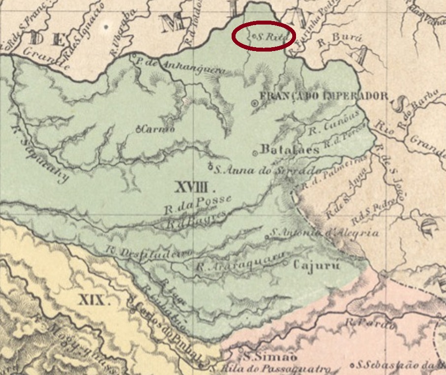
The tupi word ibitipoca means bursting mountains and may be related to thunder echoes during storms in this mountain region. Santa Rita de Ibitipoca was since July 1832 a district in the municipality of Barbacena, situated round 200 km south of the province capital Ouro Preto. In December 1938 it changed as a district to the newly founded municipality of Bias Fortes and received its administrative emancipation in December 1962.
Nova Monteiro (Administrações e Agencias Postaes do Brasil Imperio, in Brasil Filatelico/RJ, 1934-5; Reprint SPP 1994-1999) writes a creation date of September 1866 for the post office, which is confirmed by Paula Sobrinho (História Postal de Minas Gerais, Belo Horizonte, 1997).
In 1872 the agency was closed, as reported by the regional press:
O Noticiador, May 1st, 1872
It must have reopened by 1879, for it is listed in the Postal Guide (Guia Postal do Império) of 1880. Two imperial cancels were found: SMG-2910a (Coll. José A. Junges) has a double circle with the inscription S.R. DE IBITIPOCA above and a circular ornament below, cut in both diagonals. A sole example is known, dated 1886 in the centre. SMG-2910b (Coll. José A. Junges) has also the double circle, but here the inscription is S. RITA DA IBITIPOCA, and the ornament below is a cross with wide diamond wings. Dates found for the period 1889-1904.
Villiers de l’Ile Adam: Carta (…) da Provincia de Minas Geraes, 1849
Anderer Name: Ibitipoca (1938-1962)
Das Tupi-Indianerwort ibitipoca bedeutet platzende Berge und soll angeblich den Donnerkrach beschreiben, den die Gewitter der Gebirgsregion verursachen. Santa Rita de Ibitipoca war seit Juli 1832 ein Distrikt des Município von Barbacena und lag ca. 200 km südlich der ehemaligen Provinzhauptstadt Ouro Preto entfernt. Im Dezember 1938 wechselte er zum neu gegründeten Município von Bias Fortes, emanzipierte sich aber im Dezember 1962 als eigenständige Gemeinde.
Nova Monteiro (Administrações e Agencias Postaes do Brasil Imperio, in Brasil Filatelico/RJ, 1934-5; Reprint SPP 1994-1999) schreibt den September 1866 als Entstehungsdatum für das örtliche Postamt, was durch Paula Sobrinho (História Postal de Minas Gerais, Belo Horizonte, 1997) bestätigt wird. 1872 wurde die Agentur geschlossen, wie die Regionalpresse berichtet:
O Noticiador, 1. Mai 1872
Sie muss aber bis 1879 wieder geöffnet haben, da sie im Postführer (Guia Postal do Império) von 1880 aufgelistet ist. Zwei Poststempel der Kaiserzeit sind vorhanden: SMG-2910a (Samml. José A. Junges) hat einen Doppelkreis mit der Inschrift S.R. DE IBITIPOCA oben und einem kreisförmigen Ornament unten, das an beiden Diagonalen geschnitten ist. Ein einziges Exemplar ist bekannt, datiert 1886 in der Mitte. SMG-2910b (Samml. José A. Junges) hat auch einen Doppelkreis, hier aber lautet die Inschrift S. RITA DA IBITIPOCA, und das untere Ornament ist ein Kreuz mit breiten Flügeln in Rautenform. Die Daten weisen auf den Zeitraum 1889-1904 hin.