According to Paula Sobrinho (História Postal de Minas Gerais, Belo Horizonte, 1997), there were two postal agencies named Rio Doce in the Minas Gerais province during the Brazilian Empire. The elder of both was the former Freguesia de Santo Antonio do Bom Successo do Descoberto do Pessanha, which was elevated to the Villa do Rio Doce in 1875, but six years later it changed the toponym again, becoming a Cidade de Suassuhy. Paula Sobrinho states that the local post office and the Villa were created on the same day (October 25, 1875), a very unusual procedure. There follows that, even considering that seals were not quite ready at the mailing operation start and finish, all cancellations from this Villa would date approximately between 1875 and 1882. However, no Rio Novo cancellation from that period has come into light until now.
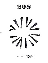
On the other hand, Reinhold Koester (Carimbologia XXXI) writes October 15, 1875 for the creation date of the post office (i.e. before Pessanha has turned to Rio Doce) and presents a Pessanha manuscript cancel on a D. Pedro emission of 1876. He also shows a mute cancellation which might be identical to Paulo Ayres #208, asserting that the respective letter was mailed in Pessanha in 1879:
Paulo Ayres #208
These two Koester examples prove that the old name Pessanha survived on letters and cancels after the toponymic change, and might indicate that the new name Rio Doce was locally not very popular.
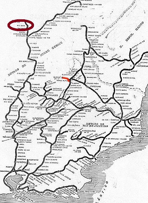
Since all known Rio Doce cancels from Minas Gerais were applied between 1887 and 1890, these must refer to the second agency, a train station post office at the Estrada de Ferro Leopoldina railroad, Dom Silvério Branch, in the municipality of Mariana. According to Ralph Giesbrecht (estacoesferroviarias.com.br), the train station was installed on December 6, 1886, and Paula Sobrinho (op. cit.) tells us the post office was created in April 1887.
The only cancel type found so far, RMG-2135a (Coll. José A. Junges), shows a double circle with inscriptions RIO-DOCE above and (MINAS) below, with dates (between 1887 and 1890, as written before) in the inner circle.
riodocenanaet.com
Laut Paula Sobrinho (História Postal de Minas Gerais, Belo Horizonte, 1997) gab es zwei Postämter in der Provinz Minas Gerais im Kaiserreich Brasilien, die Rio Doce hießen. Das älteste davon war die ehemalige Freguesia de Santo Antonio do Bom Successo do Descoberto do Pessanha, die in 1875 zur Villa do Rio Doce aufstieg, aber schon sechs Jahre später den Ortsnamen wieder gewechselt hat, zu Cidade de Suassuhy. Paula Sobrinho schreibt, sowohl Villa als auch Postamt seien am selben Tag (25. Oktober 1875) entstanden, eine sehr unübliche Konstellation. Das würde bedeuten, dass auch wenn die Poststempel nicht ganz pünktlich zum Betriebsbeginn einsatzbereit gewesen wären, alle Abstempelungen unter diesem neuen Ortsnamen wären etwa zwischen 1875 und 1882 datiert. Aber aus diesem Zeitraum ist bisher kein einziger Rio Doce-Stempel aufgetaucht.
Dafür schreibt Reinhold Koester (Carimbologia XXXI), dass das dortige Postamt bereits am 15. Oktober entstanden ist (also noch bevor aus Pessanha Rio Doce wurde) und präsentiert eine handschriftliche Entwertung mit Pessanha auf einer D. Pedro-Ausgabe aus 1876. Koester zeigt auch einen stummen Stempel, der mit Paulo Ayres Nr. 208 identisch sein könnte, und behauptet, der dazu gehörende Brief wurde in Pessanha in 1879 versendet:
Paulo Ayres Nr. 208
Diese beiden Beispiele belegen, dass der alte Ortsname Pessanha den Namenswechsel in Briefen und postalischen Entwertungen überlebt hat, und lassen die Vermutung zu, dass der neue Name Rio Doce bei der Bevölkerung nicht sehr beliebt gewesen war.
Da alle bekannten Rio Doce-Stempel aus Minas Gerais zwischen 1887 und 1890 datiert sind, müssen sie dem zweiten Postamt zugeordnet werden. Dieses war ein Bahnhofspostamt der Estrada de Ferro Leopodina, Abzweigung Dom Silvério, im Município von Mariana. Laut Ralph Giesbrecht (estacoesferroviarias.com.br) wurde der Bahnhof am 6. Dezember 1886 installiert, das Postamt dazu entstand im April 1887 (Paula Sobrinho, op. cit.).
Die einzige bisher gefundene Abstempelung, RMG-2135a (Samml. José A. Junges), zeigt einen Doppelkreis mit der Inschrift RIO-DOCE oben und (MINAS) unten, und die Daten, wie vorher genannt, sind zwischen 1887 und 1890 im Innenkreis.
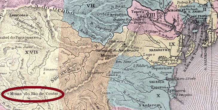
Other names: Santo Antônio do Mato Grosso, Minas do Rio de Contas
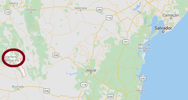
This historical town, splendidly situated in the Chapada Diamantina in Bahia, has newly experienced a revival for its tourist attractions. At the beginning, some time in 17th century, it was called Pouso dos Crioulos, a hideout for fugitive slaves on the miners’ trail between Mato Grosso and Salvador. The discovery of gold mines in the region around 1710 drew many seekers from Brazil and abroad, and from then on population has rapidly increased. In 1715 the chapel of Nossa Senhora do Livramento (actually Livramento de Nossa Senhora) was built 12 km south. Three years later, Pouso dos Crioulos was renamed Santo Antonio do Mato Grosso, and in November 1723, both settlements were united into the Villa de Nossa Senhora do Livramento das Minas do Rio de Contas. A main connecting road to Jacobina and Salvador was built in 1725, and one year later a gold smeltery was installed.
The prosperity period ended around 1800, when mines were exhausted and miners had to decide between go further and stay in the village, changing their livelihood. In 1840, the toponym was simplified to Villa de Minas do Rio de Contas, which was elevated to a town in 1885. Finally, in June 1931 the municipality was renamed Rio de Contas.
According to Nova Monteiro, the post office was created in May 1832. The first cancel, RBA-0805a, was presented by Paulo Ayres in his supplement of 1942, but since that image was not correct, this source originates from Henrique B. Ferreira (Catálogo Ilustrado dos carimbos sobre os olhos-de-boi, 4a. ed., Porto Alegre, 2017), under Nr. R5. It occurs in black, brown and red-brown, with dates probably between 1832 and 1844:
RBA-0805a, HBF #R5
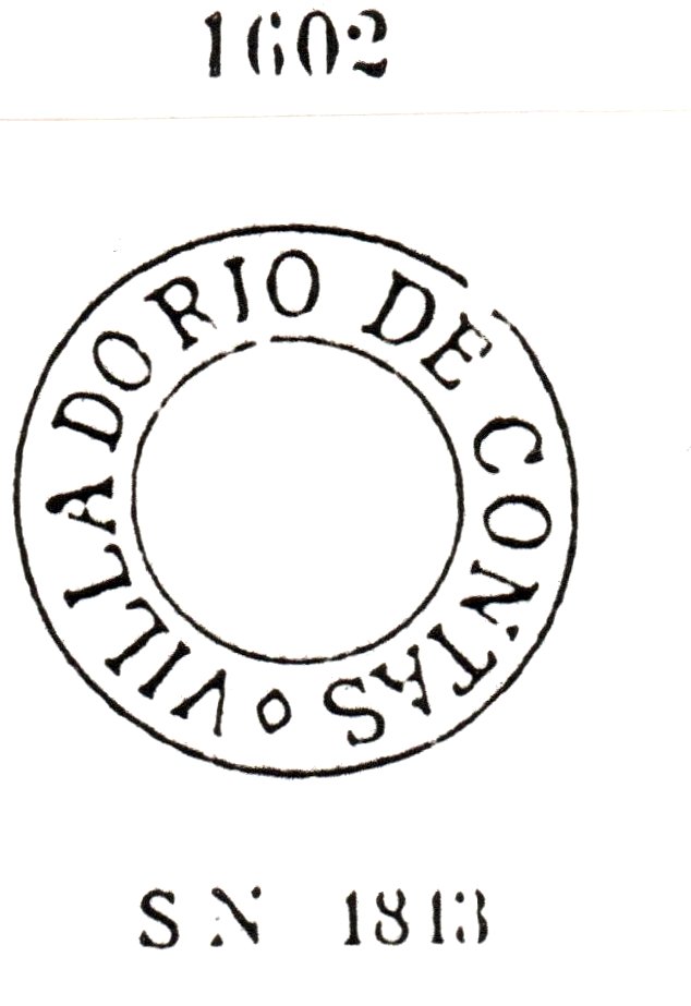
The following cancel, RBA-0805b, was presented by Paulo Ayres (1937) under #1602. However, Henrique B. Ferreira (op.cit., #R6) notes a missing dot in the diamond between CONTAS and MINAS below. It has dates between ca. 1843 and ca.1876, occurring in black, brown, red and green:
RBA-0805b, P.Ayres #1602, HBF #R6
Finally, RBA-0805c (Coll. Karlheinz Wittig) has a double circle with inscription RIO DE CONTAS above and the date in the inner circle. Exemplars found with postmarks between 1876 and 1888.
Google Maps
Andere Namen: Santo Antônio do Mato Grosso, Minas do Rio de Contas
Dieser historische Ort, reizvoll in der Chapada Diamantina im Bundesstaat Bahia gelegen, wurde in letzter Zeit wieder durch seine touristischen Vorzüge bekannt. Am Anfang, irgendwann im 17. Jahrhundert, hieß er Pouso dos Crioulos und war nicht viel mehr als ein Versteck für geflüchtete Sklaven auf der Strecke zwischen Mato Grosso und Salvador, von Goldsuchern und anderer Abenteurern als Übernachtungsort benutzt.
Die Entdeckung von Goldvorkommen um 1710 änderte die Geschichte des Orts radikal. Aus dem In- und Ausland kamen Goldssucher, die Bevölkerungszahl stieg schnell an, und schon in 1715 wurde 12 km südlich die Kapelle Nossa Senhora do Livramento (heute Livramento de Nossa Senhora) errichtet. Drei Jahre später wurde Pouso dos Crioulos in Santo Antonio do Mato Grosso umbenannt, und im November 1723 wurden beide Siedlungen vereint, unter der feierlichen Bezeichnung Villa de Nossa Senhora do Livramento das Minas do Rio de Contas. Dazu kamen eine Hauptstrasse nach Salvador über Jacobina in 1725 und ein Jahr später die Hütte für den Goldschmelz.
Ab 1800 ging es mit dem Wohlstand der Gemeinde bergab. Die Goldvorkommen waren praktisch ausgeschöpft und die Sucher mussten entscheiden, ob sie weiter ziehen oder im Ort bleiben sollten, dann aber in anderen Berufen. In 1840 wurde der Ortsname als Villa de Minas do Rio de Contas vereinfacht, und in 1885 bekam der Ort den Stadtstatus. Schließlich hieß der Município ab 1931 Rio de Contas.
Das Postamt wurde laut Nova Monteiro im Mai 1832 errichtet. Der erste Stempel, RBA-0805a, wurde durch Paulo Ayres in seinem Supplement von 1942 vorgestellt. Da aber diese Abbildung fehlerhaft ist, zeigen wir hier das von Henrique B. Ferreira (Catálogo Ilustrado dos carimbos sobre os olhos-de-boi, 4a. ed., Porto Alegre, 2017) veröffentlichte Bild, unter Nr. R5. Den Stempel gibt es in schwarz, braun und rotbraun, mit vermuteten Daten zwischen 1832 und 1844:
RBA-0805a, HBF Nr. R5
Der nächste Stempel, RBA-0805b, wurde von Paulo Ayres (1937) unter Nr. 1602 gezeigt. Dennoch hat Henrique B. Ferreira (op.cit., Nr. R6) einen fehlenden Punkt in der Raute zwischen CONTAS und MINAS (unten) festgestellt. Er hat Daten zwischen ca. 1843 und ca.1876 und kommt in schwarz, braun, rot und grün vor:
RBA-0805b, P.A. 1602, HBF Nr. R6
Der dritte Stempel, RBA-0805c (Samml. Karlheinz Wittig) hat einen Doppelkreis mit der Inschrift RIO DE CONTAS oben und dem Datum im Innenkreis. Die gefundenen Exemplare haben Stempeldaten zwischen 1876 und 1888.
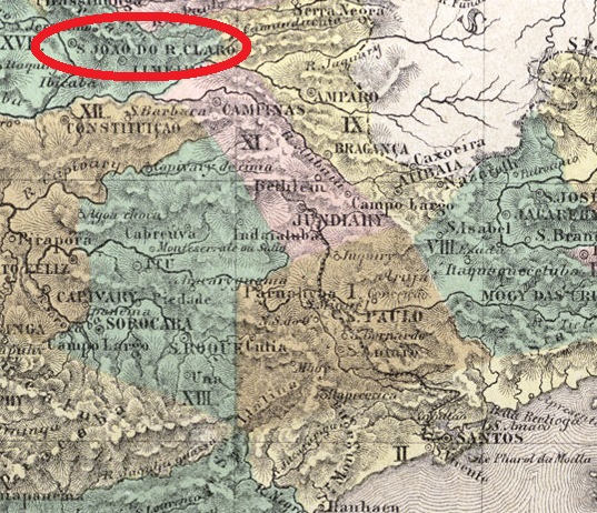
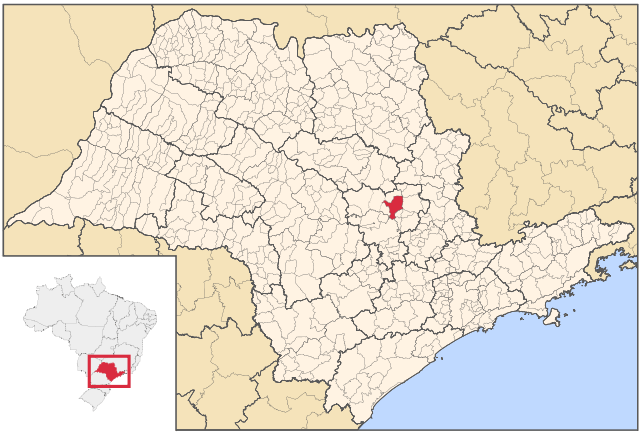
The district of São João Baptista do Rio Claro was established in December 1830 in the municipality of Piracicaba, some 180 km northwest from São Paulo. In March 1842 it passed under administrative control of the new municipality of Nossa Senhora das Dores de Tatuibi, which is called Limeira since 1863. The political emancipation came in March 1845, and in April 1857 São João do Rio Claro was declared a city. Finally, in 1905 the toponym was simplified to Rio Claro.
There are two dates for the creation of the post office. Nova Monteiro (Administrações e Agências Postaes do Brasil Império, 1798/1869, in Brasil Filatélico 18-21, 1934-5) writes September 1st, 1838, while the Imperial Mail Register (Tabella das Agencias do Correio do Império) of 1885 lists this agency as established in 1854. Possibly both dates are correct, if we assume that the office was temporarily closed in the meantime.
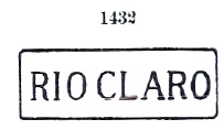
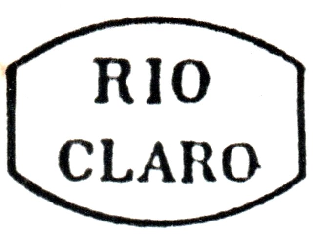
Contrary to the print edition, here all cancels featuring Rio Claro/SP and São João (or simply S.J.) do Rio Claro will be listed. Since they refer to the same locality under almost the same name, keeping them together would help avoiding confusion. RSP-1110a is doubtless the earliest postmark, found in black and brown on stamps and covers until 1856, as registered by Paulo Ayres (Catálogo de Carimbos: Brasil Império, São Paulo, 1937) under # 1432, and by Henrique B. Ferreira (Catálogo ilustrado dos carimbos sobre os olhos-de-boi, Porto Alegre, 2017) under #R4:
RSP-1110a, Paulo Ayres #1432 (1937), H.B. Ferreira: R4
RSP-1110b, the next cancel, was certainly made after April 1857, for it mentions, in black and blue, CIDADE (town) DE S. JOÃO DO RIO CLARO. Dates found until 1873, listed in Paulo Ayres under #1628:
RSP-1110b, Paulo Ayres #1628
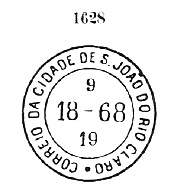
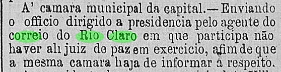
RSP-1110c (image from the internet) was found on a newspaper stamp issued in 1889, but is most probably earlier, for it is a French-type, showing the small double circle with the inscriptions RIO CLARO (above) and the typical star between parenthesis (below), and the date in the inner circle. RSP-1110d (Coll. José A. Junges) has a bigger double circle as before, with RIO CLARO above and (C.A.) below, also date in the inner circle. C.A. means Correio Ambulante, i.e. the cancel was used in the Rio Claro-São Paulo line of the Companhia Paulista railroad. According to Ralph Giesbrecht (estacoesferroviarias.com.br), the Rio Claro train station was built in August 1876, so is the cancel from a later date. Copies found cancelled between 1884 and 1888 and a Provincial Mail press release confirm this:
Correio Paulistano, April 30, 1884
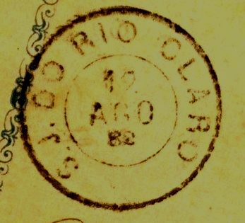
The exemplars found for RSP-1110e were cancelled between 1878 and 1890. Since this postmark does not appear in Carimbologia (Q-R) because it refers to S.J. DO RIO CLARO, it is shown here (image from the internet):
RSP-1110e
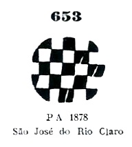
Paulo Ayres (op.cit. 1937) also lists two mute cancellations from Rio Claro, both found on D. Pedro emissions of 1878. The first one is #653, erroneously attributed to “São José do Rio Claro”, which is now a municipality from Mato Grosso established as a district as late as 1976.
José A. Junges has a letter to Naples, Italy, with a D. Pedro emission of 1866 (RHM 29, Scott 60), cancelled with P.A. 653 together with RSP-1110b and dated April 29, 1873. He also owns a fragment with a bisected D. Pedro emission of 1881 (RHM 50, Scott 81), cancelled with P.A. 653 together with RSP-1110e and dated January 4, 1884:
Paulo Ayres #653
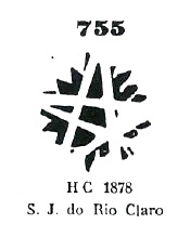
The second mute postmark listed by Paulo Ayres is #755, found on a stamp (Coll. Karlheinz Wittig) from the D. Pedro emission of 1878:
Paulo Ayres #755
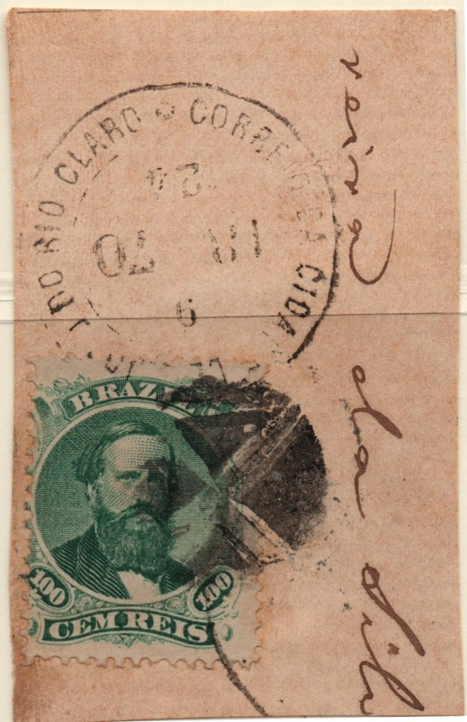
But there is probably a third mute cancel from Rio Claro/SP, unlisted in Paulo Ayres but catalogued in Dingler/Lopes (Mute Cancellations of the Brazil Empire, BPA, Rio, 2000) without local attribution, under # 1956:
J.A. Dingler/K.W. Lopes #1956
This postmark was found on a fragment with a D. Pedro emission of 1866, together with RSP-1110b and dated September 24, 1870 (Coll. José A. Junges):
Dingler/Lopes 1956 and RSP-1110bRaphael Lorenzeto de Abreu, CC-BY SA
Buchtext-Aktualisierung vom 13. April 2020
Der Distrikt von São João Baptista do Rio Claro wurde im Dezember 1830 im Verwaltungsbezirk Piracicaba gegründet, etwa 180 km nordwestlich von São Paulo. Im März 1842 ging er zum neu gegründeten Município von Nossa Senhora das Dores de Tatuibi über, der seit 1863 Limeira heißt. Die politische Emanzipierung fand in März 1845 statt, und im April 1857 stieg São João do Rio Claro zur Stadt auf. Schließlich wurde in 1905 der Ortsname zu Rio Claro vereinfacht.
Es sind zwei verschiedene Daten für die Entstehung des Postamtes überliefert. Nova Monteiro (Administrações e Agências Postaes do Brasil Império, 1798/1869, in Brasil Filatélico 18-21, 1934-5) schreibt den 1. September 1838, während das Verzeichnis der kaiserlichen Postämter (Tabella das Agencias do Correio do Império) von 1885 die Agentur mit Entstehungsjahr von 1854 auflistet. Möglicherweise sind beide Angabe korrekt, falls das Postamt zwischendurch für eine Weile geschlossen hatte.
Im Gegensatz zur gedruckten Ausgabe werden hier alle Stempel mit Rio Claro/SP und São João (oder einfach S.J.) do Rio Claro besprochen. Dadurch dass sich beide Bezeichnungen auf dieselbe Ortschaft unter fast denselben Ortsnamen beziehen, würde diese Zusammenlegung eventuell Verwechslungen vermeiden. RSP-1110a is ohne Zweifel die früheste Abstempelung, einzutreffen in schwarz und braun auf Stempeln und Ganzsachen bis 1856, wie durch Paulo Ayres (Catálogo de Carimbos: Brasil Império, São Paulo, 1937) unter Nr. 1432 registriert, sowie auch durch Henrique B. Ferreira (Catálogo ilustrado dos carimbos sobre os olhos-de-boi, Porto Alegre, 2017) unter Nr. R4:
RSP-1110a, Paulo Ayres #1432 (1937), HBF: R4
Der nächste Stempel, RSP-1110b, wurde sicherlich nach April 1857 angewendet, da er die Angabe CIDADE (Stadt) DE S. JOÃO DO RIO CLARO in schwarz oder blau enthält. Daten gefunden bis 1873, aufgelistet in Paulo Ayres unter Nr. 1628:
RSP-1110b, Paulo Ayres #1628
RSP-1110c (Abb. aus dem Internet) wurde als einziges Exemplar auf einer Zeitungsmarkea gefunden, die in 1889 ausgegeben wurde, ist aber höchstwahrscheinlich auch früher anzutreffen. Es ist ein “französischer Typ”, zeigt also den kleinen Doppelkreis mit der Inschrift RIO CLARO (oben) und den typischen Stern zwischen Klammern (unten), sowie das Datum im Innenkreis. RSP-1110d (Samml. José A. Junges) hat einen größeren Doppelkreis als sein Vorgänger, mit RIO CLARO oben und auch mit (C.A.) unten, dazu das Datum im Innenkreis. C.A. bedeutet Correio Ambulante; demnach wurde der Stempel auf der Bahnstrecke Rio Claro-São Paulo der Eisenbahngesellschaft Companhia Paulista benutzt. Laut Ralph Giesbrecht (estacoesferroviarias.com.br) wurde der Bahnhof Rio Claro im August 1876 gebaut, dann ist der Stempel später entstanden. Dies wurde durch Stempeldaten zwischen 1884 und 1888 sowie durch folgende Presseankündigung der provinzialischen Postverwaltung bestätigt:
Correio Paulistano, 30. April 1884
Die gefundenen Exemplare von RSP-1110e wurden zwischen 1878 und 1890 abgestempelt. Da diese Entwertung nicht im Heft Carimbologia (Q-R) zu finden ist, weil sie den Ortsnamen S.J. DO RIO CLARO trägt, wird sie hier vorgestellt (Abb. aus dem Internet):
RSP-1110e
Paulo Ayres (op. cit. 1937) zeigt auch zwei stummen Stempel aus Rio Claro, beide auf die D. Pedro-Ausgaben von 1878 angewendet. Der erste Stempel trägt Nr. 653 und wird irrtümlicherweise “São José do Rio Claro” zugeordnet. Dieser ist ein Município aus Mato Grosso, der erst in 1976 als Distrikt gegründet wurde.
José A. Junges besitzt einen Brief nach Neapel, Italien, mit einer D. Pedro-Ausgabe von 1866 (MiNr/RHM 29), die durch P.A. 653 entwertet wurde, und vom Stempel RSP-1110b mit Datum 29. April 1873 begleitet wird. Auch von Junges stammt ein Fragment mit einer diagonal halbierten D. Pedro-Ausgabe von 1881 (MiNr/RHM 50), die durch P.A. 653 entwertet wurde, und vom Stempel RSP-1110e mit Datum 4. Januar 1884 begleitet wird:
Paulo Ayres Nr. 653
Der zweite durch Paulo Ayres aufgelistete stumme Stempel hat die Nr. 755 und wurde auf einer Marke (Samml. Karlheinz Wittig) aus der D. Pedro-Ausgabe von 1878 aufgefunden:
Paulo Ayres Nr. 755
Es gibt wahrscheinlich einen dritten stummen Stempel aus Rio Claro/SP, der nicht im Paulo Ayres enthalten ist, wohl aber durch Dingler/Lopes (Mute Cancellations of the Brazil Empire, BPA, Rio, 2000) ohne örtliche Zuordnung unter Nr. 1956 aufgelistet wurde:
J.A. Dingler/K.W. Lopes Nr. 1956
Diese Abstempelung wurde auf einem Fragment mit einer D. Pedro-Ausgabe von 1866 gefunden, begleitet vom RSP-1110b und datiert 24. September 1870 (Samml. José A. Junges):
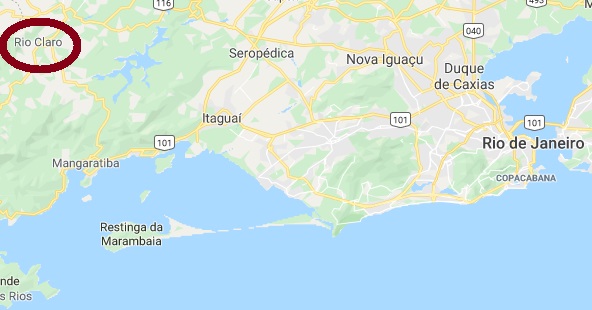
Rio Claro, situated about 130 km west from Rio de Janeiro, was since May 1839 a freguesia of São João do Príncipe. This municipality, later renamed to São João Marcos, was extinguished in 1940 for the construction of the Ribeirão das Lages barrier lake. In 1849, Rio Claro ascended to a Villa, and in December 1929 it was declared a city.
Nova Monteiro (Administrações e Agências Postaes do Brasil Império, 1798/1869, in Brasil Filatélico 18-21, 1934-5) states that the post office was created on August 18, 1855, but Aureo G. Santos (Agências de Correio Criadas e Suprimidas em 1851, 1855, 1856 e 1857, in Brasil Filatélico 181, Rio de Janeiro, 1977) has found out that the agency is one month older:
Aureo G. Santos, op.cit.
RRJ-0840a was already presented by Paulo Ayres (1937) under #1433 and is certainly the oldest postmark from Rio Claro. Found in black and violet with dates until 1866:
Paulo Ayres #1433
RRJ-0840b (Coll. Paulo Novaes) has a double circle with the inscription RIO—CLARO (above), of which the words are separated by an arrow-like ornament and the inner circle is doubled. Dates found for 1885 and 1886 inside. RRJ-0840c (Coll. José A. Junges) has a normal double circle with inscription RIO CLARO, now without special separation. The inner circle is now single, dates between 1889 and 1892 inside.
Google Maps
Rio Claro liegt etwa 30 km westlich von Rio de Janeiro und war vom Mai 1839 an eine Freguesia im Município von São João do Príncipe. Dieser wiederum hieß später São João Marcos, wurde aber in 1940 ganz gelöscht, um Platz für den Staudamm Ribeirão das Lages zu machen. In 1849 war Rio Claro zu einer Villa aufgestiegen, und in Dezember 1929 erhielt der Ort den Status einer Stadt.
Nova Monteiro (Administrações e Agências Postaes do Brasil Império, 1798/1869, in Brasil Filatélico 18-21, 1934-5) gibt den 18. August 1855 als das Entstehungsdatum fürs Postamt an, aber Aureo G. Santos (Agências de Correio Criadas e Suprimidas em 1851, 1855, 1856 e 1857, in Brasil Filatélico 181, Rio de Janeiro, 1977) fand heraus, dass die Agentur ein Monat älter wäre:
Aureo G. Santos, op.cit.
RRJ-0840a wurde bereits unter Nr. 1433 durch Paulo Ayres (1937) vorgestellt und ist sicherlich die älteste Postabstempelung aus Rio Claro. Einzutreffen in schwarz und violett, mit Daten bis 1866:
Paulo Ayres Nr. 1433
RRJ-0840b (Samml. Paulo Novaes) hat einen Doppelkreis mit der Inschrift RIO—CLARO (oben), wobei die Worte durch eine pfeilähnliche Verzierung getrennt sind, und der Innere Kreis verdoppelt wurde. Gefundene Daten für 1885 und 1886 im Innenkreis. RRJ-0840c (Samml. José A. Junges) hat einen normalen Doppelkreis mit der Inschrift RIO CLARO, nun mit ungetrennten Worten. Der Innenkreis ist jetzt einfach, mit Daten zwischen 1889 und 1892 darinnen.
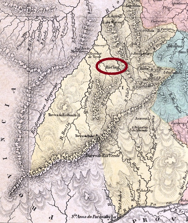
Among the three post offices in Imperial Brazil with this toponym, Rio Claro in the Goyaz (now spelled Goiás) province has certainly the most mysterious history. The first occupiers came around 1748 to search for diamonds in the Rio Claro. This river, an affluent of the Araguaya, played an important role for its situation on the trail between the province capitals of Goyaz and Mato Grosso.
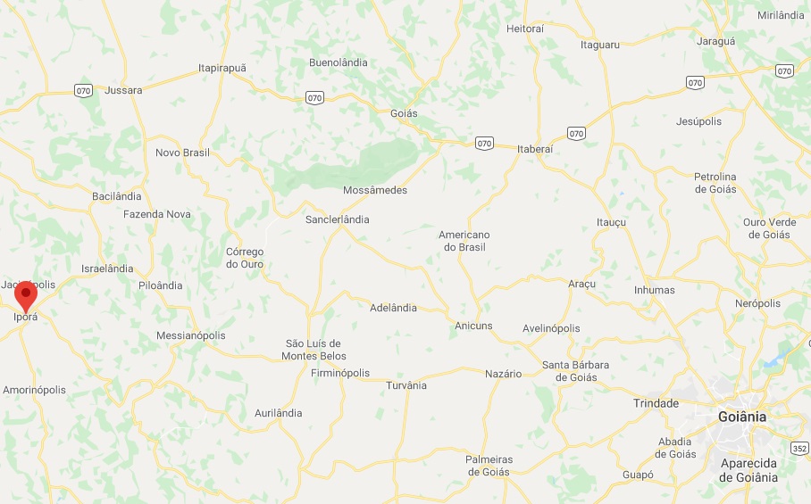
In July 1833 the district of Nossa Senhora do Rosário do Rio Claro was established in the municipality of the province capital Goyaz. Over a century later, in October 1938, the name was changed to Itajubá, which means Yellow Stone in Tupi-guarani language, but only five years afterwards it was changed again, to Iporá (= Beautiful River). Finally, in November 1948, Iporá acquired an own municipality.
An exact date for the creation of the post office has not been found so far. Since the earliest mention of it in the regional press was found for February 1875, it could have been installed shortly before:
Correio Official, February 20, 1875
Already in June 1875, a mail courier line was introduced between Rio Claro and Rio Bonito (RGO-0170). The former agency, however, was soon closed again, for neither the Guia Postal do Império of 1880 nor the Imperial Mail Register (Tabella das Agencias do Correio do Império) of 1885 list it. Considering that the Rio Bonito office was reopened in 1879, this agency must have had from then on a new mailing route. The reopening of Rio Claro apparently took place between 1885 and 1887, when it was mentioned again, now with a volunteer clerk:
Almanak de Goyaz, 1887
No imperial postmark has been found to date.
Google Maps
Unter den drei Postämtern im brasilianischen Kaiserreich mit diesem Namen, dasjenige von der Provinz Goyaz (nun Goiás geschrieben) hat sicherlich die meisten Lücken in ihrer Geschichte. Die ersten Landbesetzer kamen um 1748 auf der Suche nach Diamanten im Rio Claro. Dieser Zufluss vom mächtigen Araguaya spielte durch seine Lage eine wichtige Rolle in der Landverbindung zwischen den Provinzhauptstädten von Goyaz und Mato Grosso.
Im Juli 1833 wurde der Distrikt von Nossa Senhora do Rosário do Rio Claro im Município von Goyaz gegründet. Über ein Jahrhundert später, im Oktober 1938, der Name wechselte zu Itajubá, was in der Indianersprache Tupi-guarani Gelber Stein bedeutet. Fünf Jahre danach wurde der Ort abermals umbenannt, zu Iporá (= Schöner Fluss), und im November 1948 kam die Emanzipierung als Município.
Bisher konnte das genaue Datum der Entstehung der lokalen Post nicht ermittelt werden. Da die früheste Erwähnung darüber aus dem Februar 1875 stammt, darf man annehmen, dass das Postamt kurz davor installiert wurde:
Correio Official, 20. Februar 1875
Bereits in Juni 1875 wurde eine postalische Stafettenlinie zwischen Rio Claro und Rio Bonito (RGO-0170) bekannt gegeben. Das erste Postamt wurde dennoch bald darauf wieder geschlossen, denn es wird weder im Guia Postal do Império von 1880 noch im Verzeichnis der kaiserlichen Postämter (Tabella das Agencias do Correio do Império) von 1885 aufgelistet. Das Postamt von Rio Bonito seinerseits wurde in 1879 wieder eröffnet und wird wohl dabei eine neue Stafettenroute bekommen haben. Die Wiedereröffnung der Agentur von Rio Claro fand vermutlich zwischen 1885 und 1887 statt, der Postler hatte seinen Dienst ohne Bezahlung zu verrichten:
Almanak de Goyaz, 1887
Keine Postabstempelung der Kaiserzeit konnte bisher gefunden werden.
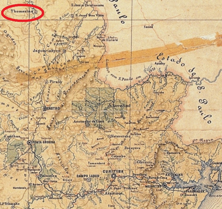
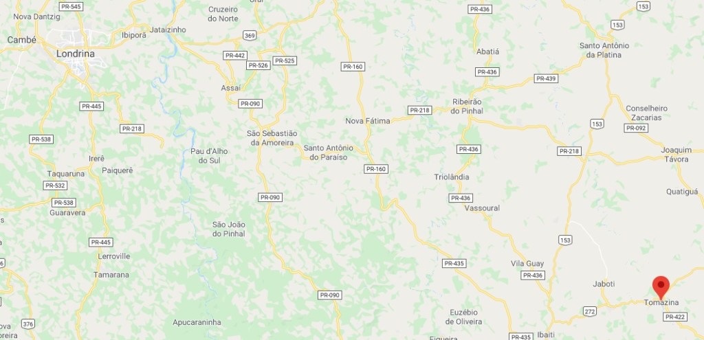
After Ribeira (Iguape, RSP-1076) and Ribeirão Preto (Faxina, RSP-1097), this is the third imperial post office discovered after the release of Carimbologia (Q-R) six months ago. Rio das Cinzas, eventually also called Rio da Cinza (= Ash River), was made in April 1879 a district of the municipality of São José da Boa Vista, the former S. José da Christandade. According to the Brazilian Institute of Geography and Statistics (IBGE), the founder was a major from Minas Gerais, called Joaquim Thomaz Pereira da Silva, who in 1865 bought a big land extension around the Rio das Cinzas, an affluent to the Paranapanema River, some 300 km northwest of Curitiba. Two years later, he started the settlements, and when the locality ascended to a freguesia in 1882, it acquired officially his name. Since May 1889 it is the municipality of Tomazina in Paraná.
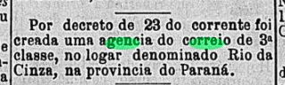
The Imperial Mail Register (Tabella das Agencias do Correio do Império) of 1885 lists a post office in Rio das Cinzas in the Paraná province, which was created in 1882. This is corroborated by the press in Rio:
Gazeta da Tarde/RJ, June 26, 1882
So far, no cancel from the Empire has appeared.
Google Maps
Aktualisierung der Buchausgabe, am 17. Mai 2021
Andere Namen: Rio da Cinza, Thomazina
Nach Ribeira (Iguape, RSP-1076) und Ribeirão Preto (Faxina, RSP-1097), dieses ist das dritte kaiserliche Postamt, das nach der Erscheinung der Carimbologia (Q-R) vor 6 Monaten entdeckt wurde. Rio das Cinzas – gelegentlich auch Rio da Cinza (= Fluss der Asche) – genannt, wurde im April 1879 als Distrikt im Verwaltungsgebiet von São José da Boa Vista (früher São José da Christandade) gegründet. Laut der brasilianischen Behörde für Geografie und Statistik (IBGE) hieß der Gründer Joaquim Thomaz Pereira da Silva, ein Major aus Minas Gerais, der in 1865 große Ländereien um den Rio das Cinzas – einen Nebenfluss des Paranapanema – etwa 300 km nordwestlich von Curitiba erwarb. Zwei Jahre später startete die Besiedlung, und als der Ort in 1882 zu einer Freguesia aufstieg, erhielt er offiziell den Namen des Gründers. Seit Mai 1889 ist es der Municipio von Tomazina in Paraná.
Das Verzeichnis der kaiserlichen Postämter (Tabella das Agencias do Correio do Império) von 1885 listet ein im Jahr 1882 gegründetes Postamt in Rio das Cinzas in der Provinz Paraná auf. Dies kann durch die Rio Presse bestätigt werden:
Gazeta da Tarde/RJ, 26. Juni 1882
Bisher ist kein Poststempel aus dieser Zeit aufgetaucht.
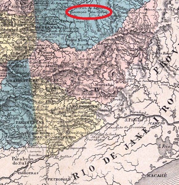
The municipality of Rio Casca was established in August 1911, after having been a district of Ponte Nova in southeast Minas Gerais for almost 50 years, under the name Nossa Senhora da Conceição do Casca. Originally, it was called povoação dos Bicudos, (i.e. the Settlements of the Pointed), allegedly an allusion to the big noses for which the first colonist’s family was known. Reinhold Koester (Carimbologia IV) writes the post office was created in October 1879, which is confirmed by the Imperial Mail Register (Tabella das Agencias do Correio do Império) of 1885. Paula Sobrinho, on the other hand, writes October 1878, which is probably a misprint.
Koester also presented an imperial manuscript cancellation featuring Bicudos with date May 1885 and a double circle cancel with CONCEIÇÃO DO CASCA, dated February 88. So it is quite improbable that a third toponym was used in the local post office within such a short time, and that would be the reason why no cancel with RIO CASCA has been found until now.
Buchtext-Korrektur vom 9. April 2020
Andere Namen: Bicudos, Conceição do Casca
Siehe auch: Bicudos/MG (Koester: Carimbologia IV)
Rio Casca erlangte den Status eines Município im August 1911, nach fast 50 Jahren als Distrikt von Ponte Nova im Südosten von Minas Gerais. Ursprünglich hieß der Ort Povoação dos Bicudos (i.e. Siedlung der Langschnäbel), angeblich als Anspielung auf die langen Nasen der ersten Kolonistenfamilie. Reinhold Koester (Carimbologia IV) nennt als Entstehungsdatum fürs örtliche Postamt den Oktober 1879, was vom Verzeichnis der kaiserlichen Postämter (Tabella das Agencias do Correio do Império) von 1885 bestätigt wird. Paula Sobrinho schreibt andererseits, das Postamt sei im Oktober 1878 entstanden, was wohl ein Tippfehler ist.
Koester präsentierte auch eine Entwertung per Hand, mit der Inschrift Bicudos und dem Datum Mai 1885, dazu auch einen Stempel mit Doppelkreis und der Inschrift CONCEIÇÃO DO CASCA, diese mit Datum Februar 1888. Somit ist es ziemlich unwahrscheinlich, dass ein dritter Ortsname in diesem Postamt binnen so kurzer Zeit im Umlauf war, und das wäre der Grund, warum keine Abstempelung mit RIO CASCA bisher aufgetaucht ist.
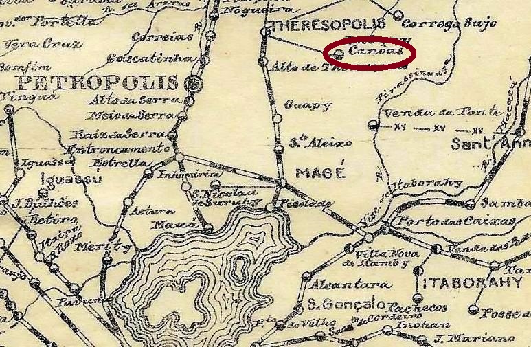
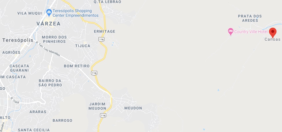
One might wonder why Rio das Canôas has ever got a post office, for it is barely visible even in detailed maps, actual or ancient. This tiny locality is hidden in a narrow valley in an eastern suburb of the touristic town Teresópolis, about 100 km north of Rio de Janeiro. Originally it belonged as a freguesia to the municipality of Magé, changing in 1891 to Santo Antonio de Paquequer and, in the next year, to Teresópolis.
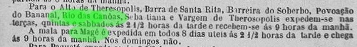
The first mention about a local post office was found in the regional press of January 1884. Possibly the agency was installed the year before:
Almanak Laemmert 1884
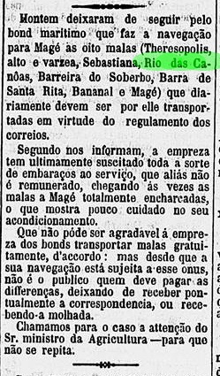
According to this mailing schedule, the mail to an from Rio das Canôas was transported three times a week through Magé. But soon serious problems have appeared on the shipway between Rio and Magé, and reclamations about damaged correspondence were made public. Since mail transportation through the Guanabara Bay had to proceed free of charge for the government, it seems that the personnel in charge has worked quite carelessly:
Diario de Noticias, November 15, 1885
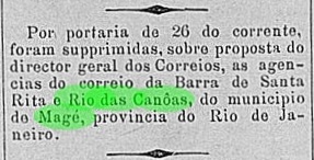
The Rio das Canôas post office had apparently no financial success and closed on February 26, 1886:
A Vanguarda, February 27, 1886
No imperial cancel of Rio das Canôas has come to light until now. Given the short operation period of such a little office, local postmarks must be very rare.
Wikimedia – OpenStreetMap
Es ist schon verwunderlich, wie Rio das Canôas zu einem eigenen Postamt kam, wenn man den Ort schon kaum auf einer detaillierten Karte findet, egal wie alt diese sein mag. Diese winzige Ortschaft liegt versteckt in einem engen Tal bei einem Vorort östlich von Teresópolis, gut 100 km nördlich von Rio de Janeiro entfernt. Ursprünglich eine unbedeutende freguesia von Magé, ging Rio das Canôas in 1891 zum neu gegründeten município von Santo Antonio de Paquequer, und im darauf folgenden Jahr zu Teresópolis.
Die bisher früheste Erwähnung eines Postamtes in Rio das Canôas findet man in der regionalen Presse in Januar 1884, so dass die Agentur möglicherweise im Jahr zuvor entstand:
Almanak Laemmert
Dem Postfahrplan nach wurden die Sendungen von und nach Rio das Canôas dreimal wöchentlich über Magé befördert. Da die Postverbindung zwischen Rio und Magé per Schiff entlang der Bucht von Guanabara alles andere als unproblematisch war, wurden bald Kundenbeschwerden über beschädigte Postsendungen veröffentlicht. Über die kostenlose Pflichtbeförderung der Post waren die Matrosen wohl nicht erfreut und ließen offenbar Sorgfalt vermissen:
Diario de Noticias, 15. November 1885
Dem kleinen Postamt in Rio das Canôas war kein finanzieller Erfolg gegönnt, es musste bereits am 26. Februar 1886 schließen:
A Vanguarda, 27. Februar 1886
Kein imperialer Stempel aus Rio das Canôas war bisher zu sehen. Bei einer so kurzen Betriebszeit eines so kleinen Orts müssen Abstempelungen von dort sehr selten sein.
Carta da Republica dos Estados Unidos do Brazil, 1892
See also: Presídio, S. João Batista do (Koester: Carimbologia XXXII, 1992)
Other names: Presídio, Presídio de Ubá, São João Baptista do Presídio, Villa do Prezidio, Visconde do Rio Branco
The long rivalry between the neighbour towns of Visconde do Rio Branco and Ubá in southeast of Minas Gerais has historical roots. The former was originally a district of the municipality of Pomba in 1810, with the sonorous name Distrito de São João Baptista dos Índios Coropós. Eventually after that, the locality became an open prison, surrounded by woods and called S. João Baptista do Presídio, which was made a Villa in February or March 1839. Sometime later there must have been an economic decay, for in 1853 it was degraded to a district of the municipality of Ubá and therefore called Presídio de Ubá (= Ubá Prison). It recovered the old name and Villa status only in 1881, and in the following year was elevated to a town named Visconde do Rio Branco. Such measures show understandingly a wish to leave behind both names of prison and Ubá, even though José Maria da Silva Paranhos, the Viscount of Rio Branco (1819-1880), father of the famous Baron of Rio Branco, probably never visited Minas Gerais.
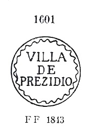
According to Nova Monteiro (Administrações e Agências Postaes do Brasil-Império 1798-1869), a post office was created in December 1839, but seems to have been closed by 1856, for it is absent in Guia do Correio do Brazil of 1857. A famous postal cancel from this early period was used on Bull’s Eyes and already presented by Paulo Ayres (1937) under #1601:
Paulo Ayres (1937) #1601
However, Ayres writes erroneously Villa DE Prezidio, while further research has already confirmed the correct spelling Villa DO Prezidio (see H. B. Ferreira, Catálogo Ilustrado dos Carimbos sobre os Olhos-de-Boi, 4th ed., 2017).
Apparently the post office reopened only in September 1870 (Paula Sobrinho: História Postal de Minas Gerais, Belo Horizonte, 1997). The postmarks from this period were already shown by R. Koester under Presídio (Carimbologia XXXII, Rio, 1992).
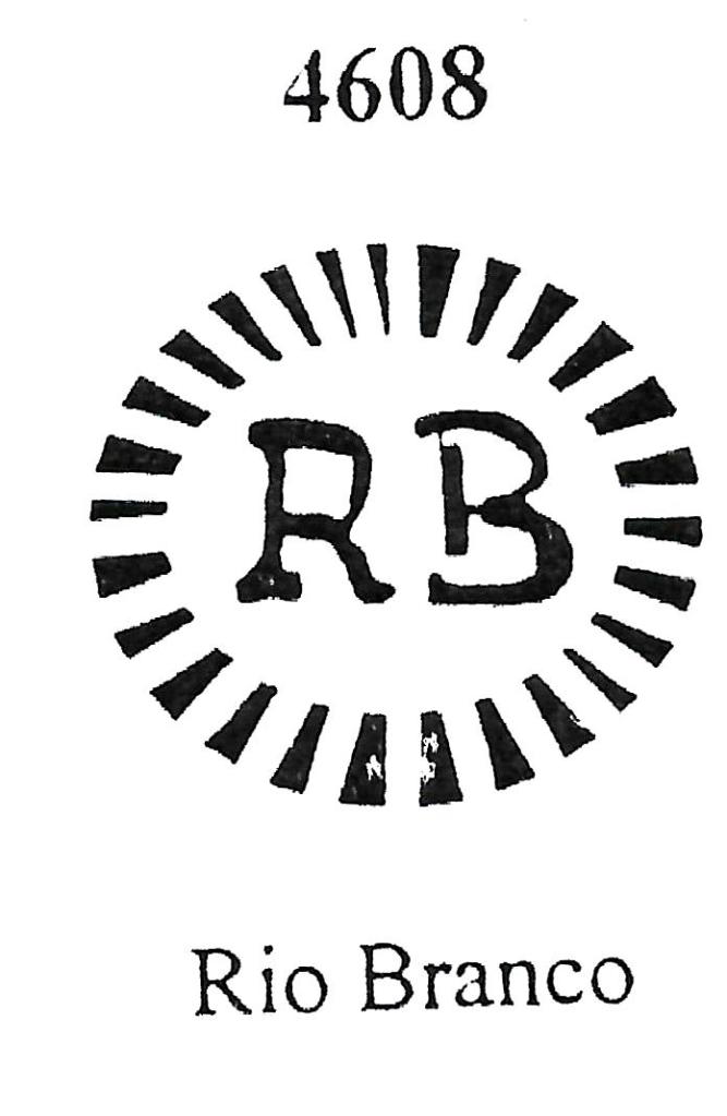
There are to date four different cancels known for Rio Branco from the late imperial period (1882-1889). RMG-2110a corresponds to Paulo Ayres’ #1110, and was used between 1882 and 1883, probably as a stopgap. This cancel was also catalogued by J.A. Dingler and K.W. Lopes (Mute Cancellations of the Brazil Empire, 1865-1889, Rio de Janeiro, 2000) under # 4608. Both images have significant differences, making their comparison interesting:
Paulo Ayres (1937) #1110Dingler/Lopes (2000) #4608
RMG-2110b (Coll. Karlheinz Wittig) is a gorgeous shell-shaped cancel, absent in Paulo Ayres: there is a bowed inscription CORREIO DO RIO BRANCO above, MINAS GERAES below, and the date in the middle. Found between 1884 and 1886 in black, blue, violet and lilac. RMG-2110c (Coll. José A. Junges) has a double circle with the inscriptions RIO BRANCO above, MINAS below, and the date in the inner circle. Found in violet and lilac from 1885 to 1886. Finally, RMG-2110d (Coll. José A. Junges) shows a double circle with bigger letters than the former. The inscriptions are RIO=BRANCO above, (MINAS) below, and date in the inner circle. Found in black and lilac from 1887 until 1892.
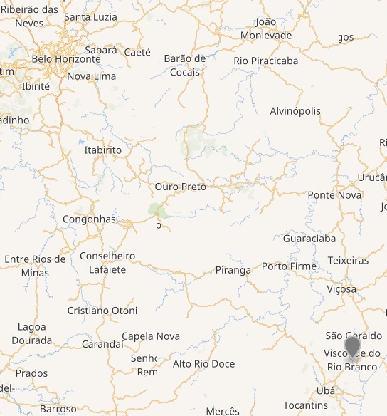
Wikimedia – OpenStreetMap
Siehe auch: Presídio, S. João Batista do (Koester, Carimbologia XXXII, 1992)
Andere Namen: Presídio, Presídio de Ubá, São João Baptista do Presídio, Villa do Prezidio, Visconde do Rio Branco
Die lange Rivalität zwischen den Nachbarstädtchen Visconde do Rio Branco und Ubá im Südosten von Minas Gerais hat eine ebenso lange Vorgeschichte. Erstes war ursprünglich (ab 1810) ein Distrikt im Município von Pomba, mit dem wohlklingenden Namen Distrito de São João Baptista dos Índios Coropós. Irgendwann danach wurde aus der Ortschaft ein offenes Gefängnis mitten im Urwald, das sich S. João Baptista do Presídio nannte, das im Februar oder März 1839 als Villa aufgewertet wurde. Aber später soll es wirtschaftlich so weit bergab gegangen sein, dass die Villa in 1853 zum Distrikt vom Nachbar Ubá degradiert wurde, unter dem – zugegeben nicht sehr schmeichelhaften – Namen Presídio de Ubá (= Ubás Gefängnis). Der Status einer Villa mit eigener Verwaltungsautonomie wurde erst in 1881 wieder erlangt, und ein Jahr später war der Ort zur Stadt Visconde do Rio Branco umbenannt. Die letzten Verwaltungsakte zeigen unmissverständlich den Wunsch, die Bezeichnungen Presídio und Ubá loszuwerden, auch wenn José Maria das Silva Paranhos (1819-1880), der Vicomte von Rio Branco und Vater des berühmten Baron von Rio Branco, womöglich niemals in Minas Gerais unterwegs war.
Laut Nova Monteiro (Administrações e Agências Postaes do Brasil-Império 1798-1869) wurde ein Postamt bereits im Dezember 1839 errichtet, das gleichwohl schon vor 1856 wieder geschlossen war, da es nicht im Guia do Correio do Brazil von 1857 aufgelistet wurde. Von dieser Frühzeit ist ein einziger Stempel überliefert, der auf Ochsenaugen zu finden ist und von Paulo Ayres (1937) unter Nr. 1601 registriert wurde:
Paulo Ayres (1937) Nr. 1601
Ayres schreibt dennoch fälschlicherweise Villa DE Prezidio, aber die spätere Forschung hat den Fehler behoben und die Schreibweise auf Villa DO Prezidio korrigiert (siehe H. B. Ferreira, Catálogo Ilustrado dos Carimbos sobre os Olhos-de-Boi, 4.. Aufl., 2017).
Das Postamt wurde wahrscheinlich erst im September 1870 (Paula Sobrinho: História Postal de Minas Gerais, Belo Horizonte, 1997) wieder eröffnet. Die Stempel aus dieser Zeit wurden bereits von R. Koester unter Presídio (Carimbologia XXXII, Rio, 1992) vorgestellt.
Es sind vier verschiedene Abstempelungen für Rio Branco aus der späteren kaiserlichen Zeit (1882-1889) bekannt. RMG-2110a entspricht Paulo Ayres’ Nr.1110, und wurde in 1882 und 1883 benutzt, wohl als Provisorium. Dieser Stempel wurde auch von J.A. Dingler and K.W. Lopes (Mute Cancellations of the Brazil Empire, 1865-1889, Rio de Janeiro, 2000) unter Nr. 4608 katalogisiert. Die Abbildungen zeigen aber wesentliche Unterschiede, so dass ein Vergleich hier interessant wird:
Paulo Ayres (1937) Nr. 1601Dingler/Lopes (2000) Nr. 4608
RMG-2110b (Samml. Karlheinz Wittig) ist ein wunderbarer Stempel in Muschelform, nicht in Paulo Ayres enthalten: da sehen wir eine gebogene Inschrift CORREIO DO RIO BRANCO oben, MINAS GERAES unten, und das Datum in der Mitte. Einzutreffen zwischen 1884 und 1886 in den Farben schwarz, blau, violett und lila. RMG-2110c (Samml. José A. Junges) hat einen Doppelkreis mit der Inschrift RIO BRANCO oben, MINAS unten und das Datum im Innenkreis. Einzutreffen in den Farben violett und lila von 1885 bis 1886. Schließlich RMG-2110d (Samml. José A. Junges) zeigt einen Doppelkreis mit etwas größere Buchstaben als vorher. Die Inschriften sind RIO=BRANCO oben und (MINAS) unten, mit Datum im Innenkreis. Einzutreffen in schwarz und lila von 1887 bis 1892.
The district of Nossa Senhora da Piedade do Rio Bonito was created in February 1866 in the municipality of Botucatu, some 200 km west from São Paulo. After being elevated to a Villa in 1880 and to a Município in 1882, since December 1921 it is called Bofete. The actual toponym derives from French buffet, which in old Portuguese could also mean “trail guest house”. This suggests that the locality had lodged a groceries store for travellers.
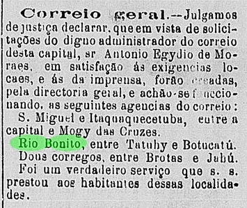
The post office was established in 1872, according to the Imperial Mail Register (Tabella das Agencias do Correio do Império) of 1885, which can be ratified by the regional press:
Diario de São Paulo, March 20, 1872
No imperial postal cancel was found to date.
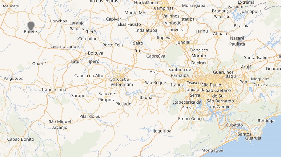
Wikimedia – OpenStreetMap
Der Distrikt von Nossa Senhora da Piedade do Rio Bonito wurde im Februar 1866 gegründet und lag im Verwaltungsbezirk Botucatu knapp 200 km westlich von São Paulo entfernt. Nachdem er in 1880 zur Villa und in 1882 zu einem Município aufstieg, wurde der Ort in Bofete in 1921 umbenannt. Dieser etwas seltsam anmutende Name kommt vom französischen buffet, was im Alt-Portugiesisch auch etwa Landgasthaus bedeuten konnte. Angeblich hat der Ort früher ein Lebensmittelgeschäft für Reisende beherbergt.
Im Verzeichnis der kaiserlichen Postämter (Tabella das Agencias do Correio do Império) von 1885 wird die örtliche Poststelle mit Entstehungsjahr 1872 aufgelistet, was von der regionalen Presse bestätigt wird:
Diario de São Paulo, 20. März 1872
Kein Poststempel aus der Kaiserzeit wurde bisher gefunden.