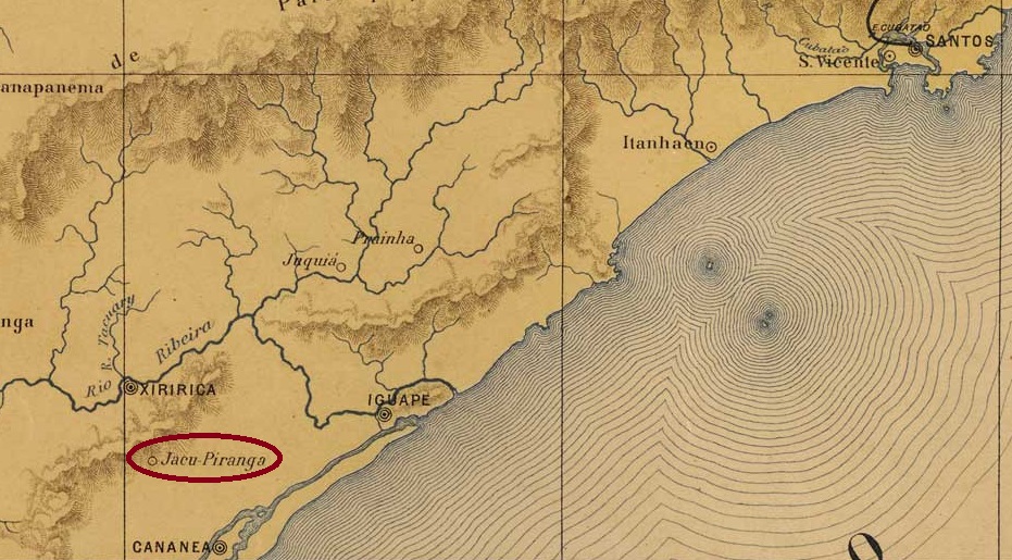
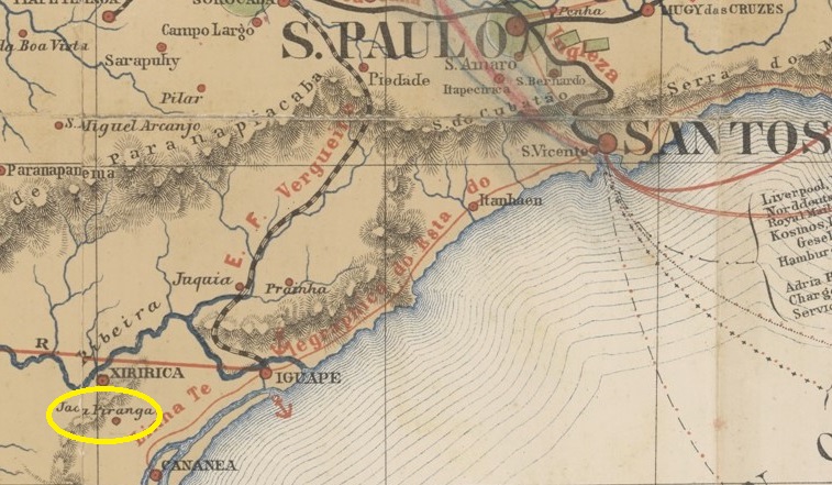
The settlement, which had been known as Botujuru since 1864, belonged to the Vila de Iguape and was located on the south bank of the Jacupiranga, 220 kilometres southwest of the provincial capital of São Paulo. In April 1870, it became the Freguesia de N. Sra. da Conceição do Jacupiranga and has been an independent município since December 1927. The beautiful name comes from the Tupi-guarani and refers to a bird with a red breast of the Cracidae family.
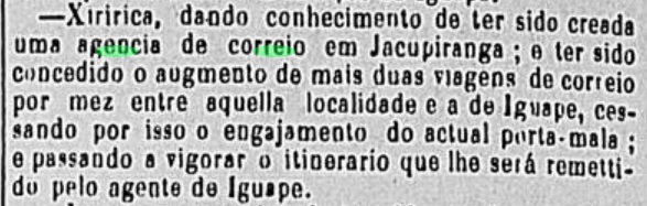
As reported in the local press, the local post office was created in September 1877:
Correio Paulistano, 23/10/1877
However, postal traffic to and from Jacupiranga had already existed two years earlier:
Correio Paulistano, 08/09/1875
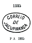
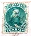
The oldest postmark is JSP-0685a, which was given the no. 1335 by P. Ayres in Catálogo de Carimbos Brasil-Império (S. Paulo, 1937, 1942):
JSP-0685a (P.A. 1335) 1877ff-1885ff
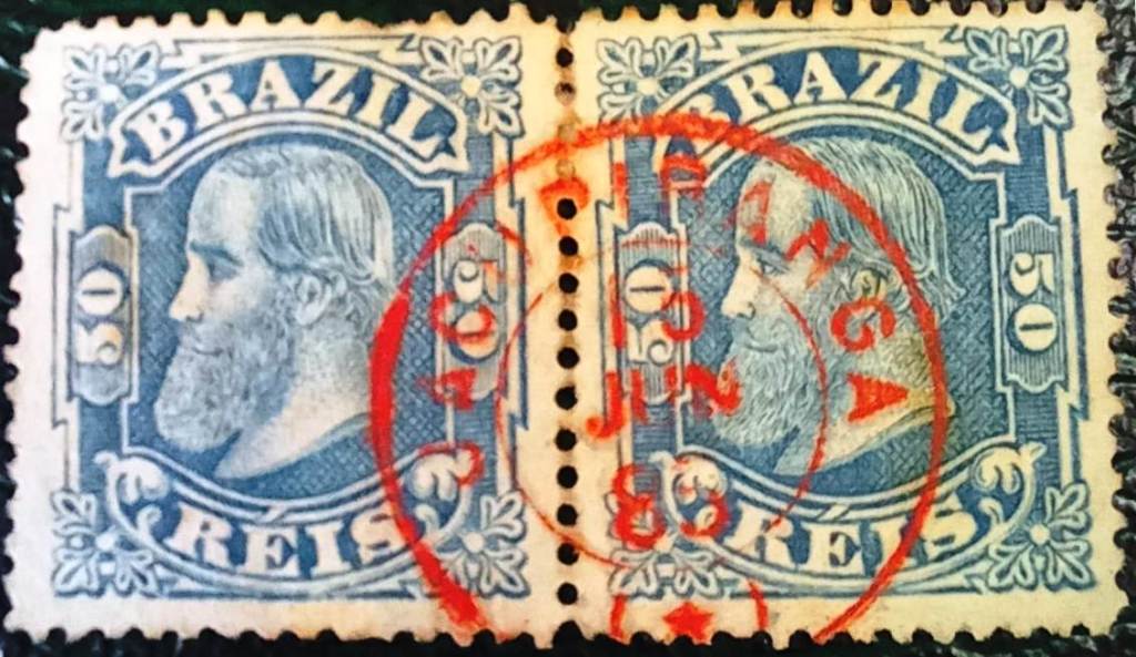
This was followed by JSP-0685b (coll. Fuad Ferreira Fo.), which also occurs in red:
JSP-0685b (FF) 1878ff-1883ffProvincia de São Paulo, 1886
Andere Namen: Botujuru
Die seit 1864 unter dem Namen Botujuru nachweisbare Siedlung gehörte zur Vila de Iguape und lag am Südufer des Jacupiranga, 220 km südwestlich der Provinzhauptstadt São Paulo. Im April 1870 wurde sie zur Freguesia de N. Sra. da Conceição do Jacupiranga und ist seit Dezember 1927 ein eigenständiges Município. Der schöne Name stammt aus dem Tupi-guarani und bezeichnet einen Vogel mit roter Brust der Familie Cracidae.
Villiers de l’Ile Adam: Carta (…) das Provincias de Pernambuco, Alagoas e Sergipe, 1848
Other names: Jacuitinga (1943-1958)
From March 1707, Jacuhipe was an arraial of the Vila de Porto Calvo on the south bank of the Jacuípe on the border with Pernambuco, 130 kilometres north of the later provincial capital of Maceió. In 1890 it was already a district with the name S. Caetano do Jacuhipe. The place name was changed to Jacuitinga in December 1943, but reverted with the spelling Jacuípe in July 1958.
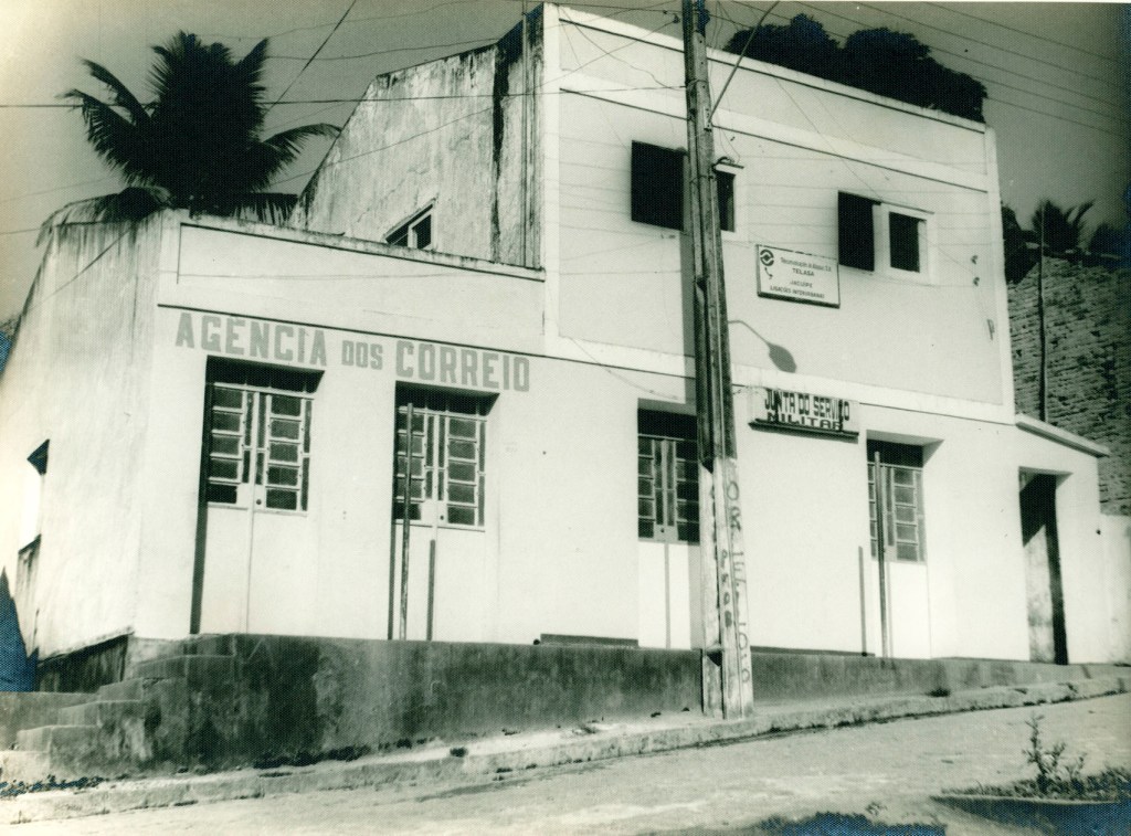
Jacuípe post office, around 1960 (IBGE)
As Aldo Cardoso writes in Contribuição para a História dos Correios de Alagoas (Maceió, 1969), there had been a post office there since October 1886. No imperial postmarks from Jacuhipe have yet been seen.
Atlas do Imperio do Brasil, 1868
Andere Namen: Jacuitinga (1943-1958)
Seit März 1707 war Jacuhipe ein Arraial der Vila de Porto Calvo am Südufer des Jacuípe an der Grenze zu Pernambuco, 130 km nördlich der späteren Provinzhauptstadt Maceió. Im Jahre 1890 war es bereits ein Bezirk mit dem Namen S. Caetano do Jacuhipe. Der Ortsname wurde im Dezember 1943 in Jacuitinga geändert, kehrte aber im Juli 1958 zur Schreibweise Jacuípe zurück.
Postamt Jacuípe, um 1960 (IBGE)
Wie Aldo Cardoso in Contribuição para a História dos Correios de Alagoas (Maceió, 1969) schreibt, gab es dort seit Oktober 1886 ein Postamt. Bisher wurden keine kaiserlichen Poststempel aus Jacuhipe gesehen.
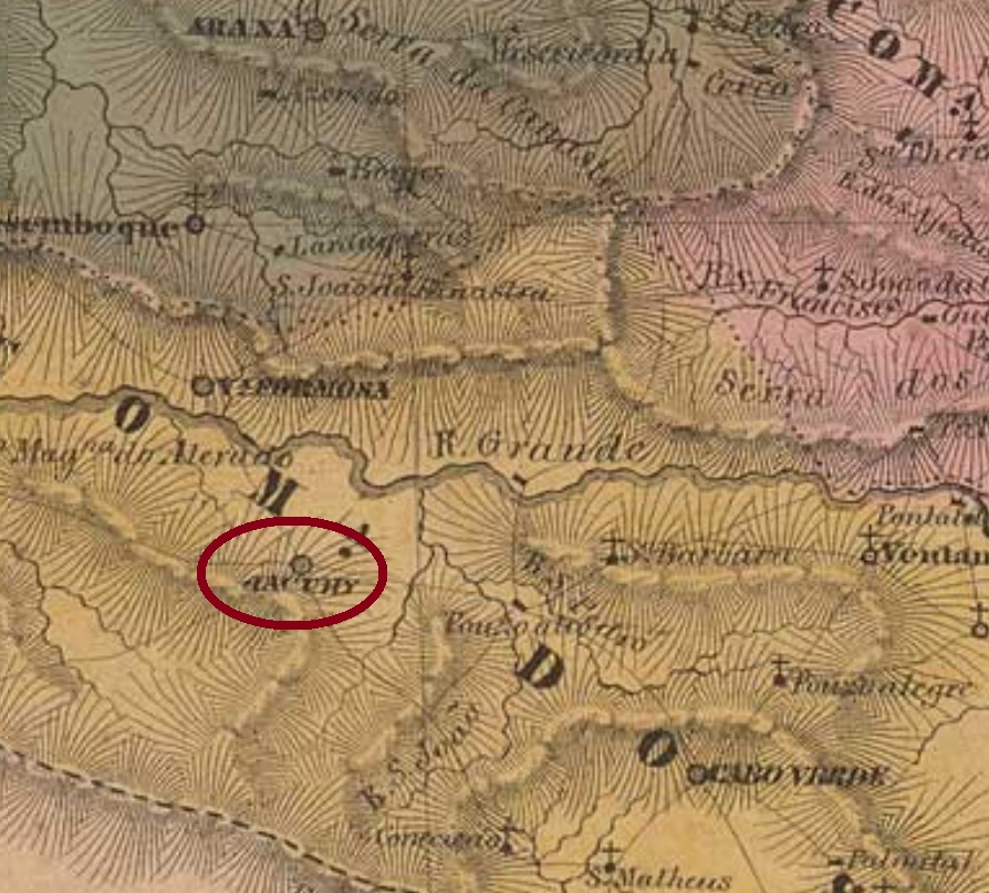
Villiers de l’Ile Adam: Carta (…) da Provincia de Minas Geraes, 1849
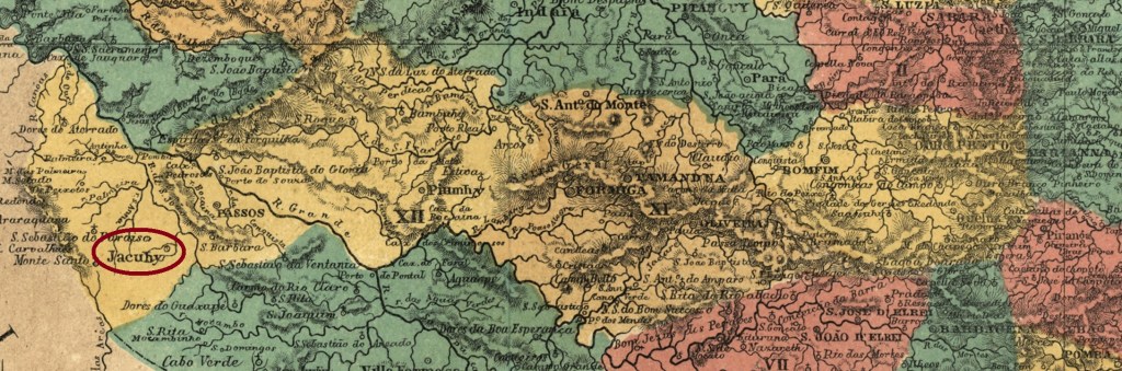
Other names: Descoberto de N.S. da Conceição do Rio Grande, Ribeirão de S. Pedro de Alcântara e Almas
See also São Carlos de Jacuhy (SMG-1405)
This is another locality in the Minas Gerais province whose turbulent history reflects in many dates, although its earliest names (see above) apparently were never official. A former freguesia of Campanha, it arose to a villa as soon as July 1814 and to a town in October 1869. At that time, the local economy must have been already in trouble, for less than a year later it became a simple district of São Sebastião do Paraizo. In September 1881 it recovered the villa status, and in the early republic, in May 1892, it was a town again. Since September 1923 it is called simply Jacuhy, now spelled Jacuí.
Accordingly, three different years were found for the creation of the local post office. Nova Monteiro (Administrações e Agencias Postaes do Brasil Imperio, in Brasil Filatelico/RJ, 1934-5; Reprint SPP 1994-1999) writes the earliest date: March 5, 1829. Paula Sobrinho (História Postal de Minas Gerais, Belo Horizonte, 1997) asserts it took place on September 12, 1833. This could be a misprint, for both R. Koester (Carimbologia XXV) and the Imperial Mail Register (Tabella das Agencias do Correio do Imperio, Rio de Janeiro, 1885) list this agency with the same date, but now within the year 1883.
As this post office still appears in the agency list of 1869, but no longer in the list of 1872, it can be assumed that it was closed around the time Jacuhy lost its status as a Vila.
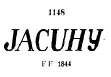
The postmark JMG-1405a, which also appears in red, dates from the agency’s first period of operation and was given the no. 1148 by P. Ayres in the Catálogo de Carimbos Brasil-Império (S. Paulo, 1937, 1942), here also in an illustration by Marcio Duarte:
JMG-1405a (P.A. 1148 – MD) 1839-1847
R. Koester showed the rare cancel JMG-1405b in Carimbologia XXV:
JMG-1405b (RK) 1854ff
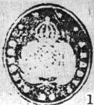
Koester (op. cit.) also presented the postmark with the imperial seal JMG-1405c:
JMG-1405c (RK)
For cancels with São Carlos de Jacuhy (from 1883) see SMG-1405.
Atlas do Imperio do Brasil, 1868
Andere Namen: Descoberto de N.S. da Conceição do Rio Grande, Ribeirão de S. Pedro de Alcântara e Almas
Siehe auch São Carlos de Jacuhy (SMG-1405)
Diese ist wieder eine Ortschaft in der Provinz Minas Gerais, deren turbulente Geschichte sich in vielen Daten widerspiegelt, obwohl die ersten Ortsbezeichnungen (siehe oben) scheinbar nicht registriert wurden. Die ehemalige Freguesia der Gemeinde Campanha stieg bereits im Juli 1814 zur Villa auf, und im Oktober 1869 zu einer Stadt. Allerdings scheint die damalige Wirtschaftslage bereits schwer unter Beschuss gewesen zu sein, denn weniger als ein Jahr später wurde aus dem Ort ein einfacher Distrikt von São Sebastião do Paraizo. Im September 1881 wurde der Villa-Status wieder erreicht, und im Mai 1892, also schon in der Republik, wurde die Ortschaft wieder eine Stadt, die seit September 1923 einfach Jacuhy heißt, heute Jacuí geschrieben.
Der Geschichte entsprechend sind drei verschiedene Jahresangaben fürs örtliche Postamt überliefert. Nova Monteiro (Administrações e Agencias Postaes do Brasil Imperio, in Brasil Filatelico/RJ, 1934-5; Reprint SPP 1994-1999) schreibt davon das früheste, den 5. März 1829. Paula Sobrinho (História Postal de Minas Gerais, Belo Horizonte, 1997) behauptet, die Postamtsentstehung fand erst am 12. September 1833 statt. Das könnte aber auch ein Druckfehler sein, da sowohl R. Koester (Carimbologia XXV) als auch das Verzeichnis der kaiserlichen Postämter (Tabella das Agencias do Correio do Imperio) von 1885 listen diese Agentur – mit gleichem Datum – ab dem Jahr 1883 auf.
Da dieses Postamt noch in der Agenturliste von 1869, aber nicht mehr in der Liste von 1872 auftaucht, kann man davon ausgehen, dass es um die Zeit geschlossen wurde, als Jacuhy den Status einer Vila verlor.
Aus der ersten Betriebsperiode der Agentur stammt der Poststempel JMG-1405a, der auch in rot vorkommt und die Nr. 1148 von P. Ayres im Catálogo de Carimbos Brasil-Império (S. Paulo, 1937, 1942) erhielt, hier auch in einer Abbildung von Marcio Duarte:
JMG-1405a (P.A. 1148 – MD) 1839-1847
R. Koester zeigte den seltenen Stempel JMG-1405b in Carimbologia XXV:
JMG-1405b (RK) 1854ff
Koester (op. cit.) zeigt auch den Stempel mit dem kaiserlichen Siegel JMG-1405c:
JMG-1405c (RK)
Für Stempel mit São Carlos de Jacuhy (ab 1883) siehe SMG-1405.
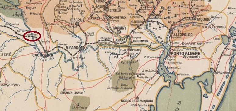
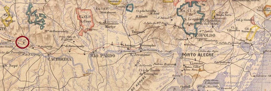
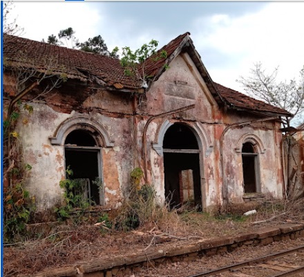
Jacuhy station was opened in December 1883 by the railway company E.F. Porto Alegre a Uruguayana (main line) and was located near the west bank of the Jacuí in the Município de Cachoeira (today Cachoeira do Sul). The line then changed hands three times: in 1898 it went to the Cie. Auxiliaire des Chemins de Fer du Brésil, in 1920 to the V. F. do Rio Grande do Sul and from 1975 until its closure in 1996 it belonged to Rede Ferroviária Federal S.A. (estacoesferroviarias.com.br). Today, the tracks are still there, but the station building is in ruins.
In April 2024 (Photo: Vaner Boaratti, on Google Maps)
Since March 1959, the railway station has been in the Município de Restinga Seca.
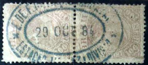
The station post office was opened around 1884, the oldest postmark JRS-0585a (collector André Matzenbacher) was used in this year:
JRS-0585a (André Matzenbacher) 1884
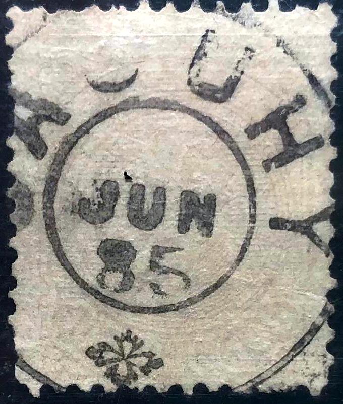
The successor postmark JRS-0585b also comes from the Matzenbacher collection:
JRS-0585b (André Matzenbacher) 1885Estado do Rio Grande do Sul, 1891
Der Bahnhof Jacuhy wurde im Dezember 1883 von der Eisenbahngesellschaft E.F. Porto Alegre a Uruguayana (Hauptlinie) eröffnet und lag nahe dem Westufer des Jacuí im Município de Cachoeira (heute Cachoeira do Sul). Danach wechselte die Strecke dreimal den Besitzer: 1898 ging sie an die Cie. Auxiliaire des Chemins de Fer du Brésil, 1920 an die V. F. do Rio Grande do Sul und von 1975 bis zu ihrer Stilllegung 1996 gehörte sie der Rede Ferroviária Federal S.A. (estacoesferroviarias.com.br). Heute sind die Gleise noch vorhanden, das Bahnhofsgebäude ist eine Ruine.
Im April 2024 (Foto: Vaner Boaratti, auf Google Maps)
Seit März 1959 befindet sich der Bahnhof im Município de Restinga Seca.
Das Bahnhofspostamt wurde um 1884 eröffnet, der älteste Poststempel JRS-0585a (Samml. André Matzenbacher) wurde in diesem Jahr verwendet:
JRS-0585a (André Matzenbacher) 1884
Der Nachfolgestempel JRS-0585b stammt ebenfalls aus der Sammlung Matzenbacher:
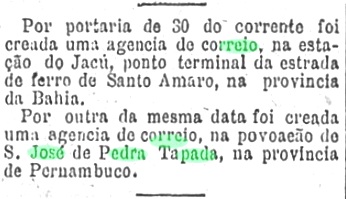
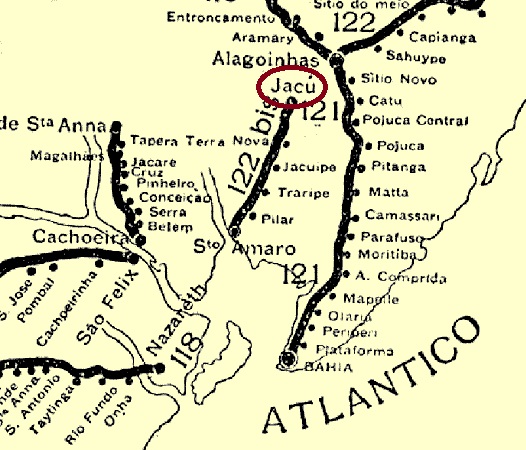
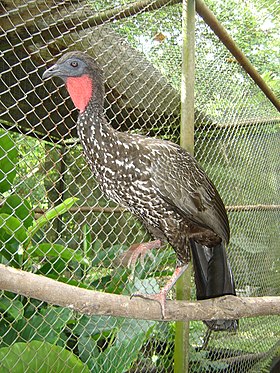
Jacú station was opened in December 1883 by the railway company E.F. de Sto. Amaro (Bom Jardim branch) in the Município de Sto. Amaro, 90 kilometres north of the provincial capital Salvador da Bahia. The line belonged to V.F.F. Leste Brasileiro from 1939 until it was closed in 1964. Since October 1961, the station has been in the Distrito de Jacu, which belongs to the Município de Terra Nova. Today, the station building has presumably been demolished and the tracks have also disappeared (estacoesferroviarias.com.br). The name from the Tupi-guarani refers to many bird species of the Penelope genus:
Penelope purpurascens (Photo: Autosafari, CC BY-SA 3.0)
In May 1884, the Rio press decided to set up a post office at the railway station:
Gazeta de Noticias/RJ, 31/05/1884
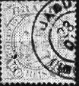
As imperial postmark R. Koester has shown in Carimbologia XXV an image, which might be wrong:
1884 (RK)
The philatelist Cesar Bolzan also presented a handwritten cancellation from this post office:
1889 (Cesar Bolzan)Rede Ferroviária da Bahia, 1898 (IBGE)
Der Bahnhof Jacú wurde im Dezember 1883 von der Eisenbahngesellschaft E.F. de Sto. Amaro (Zweig Bom Jardim) eröffnet und lag im Município de Sto. Amaro, 90 km nördlich der Provinzhauptstadt Salvador da Bahia. Die Strecke gehörte von 1939 bis zu ihrer Stilllegung 1964 der V.F.F. Leste Brasileiro. Seit Oktober 1961 befindet sich der Bahnhof im Distrito de Jacu, der zum Município de Terra Nova gehört. Heute ist das Bahnhofsgebäude vermutlich abgerissen, auch die Gleise sind verschwunden (estacoesferroviarias.com.br). Der Name aus dem Tupi-guarani bezeichnet viele Vogelarten der Gattung Penelope:
Penelope purpurascens (Foto: Autosafari, CC BY-SA 3.0)
Im Mai 1884 wurde in der Presse von Rio der Beschluss gefasst, am Bahnhof ein Postamt einzurichten:
Gazeta de Noticias/RJ, 31.05.1884
Als Reichspoststempel hat R. Koester in Carimbologia XXV ein Bild gezeigt, das falsch sein könnte:
(RK) 1884ff
Der Philatelist Cesar Bolzan zeigte auch eine handschriftliche Entwertung aus diesem Postamt:
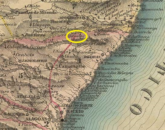
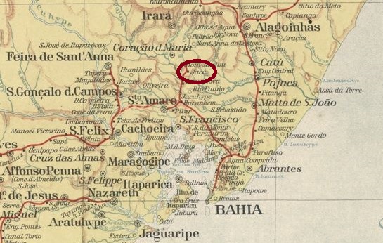
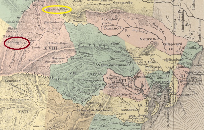
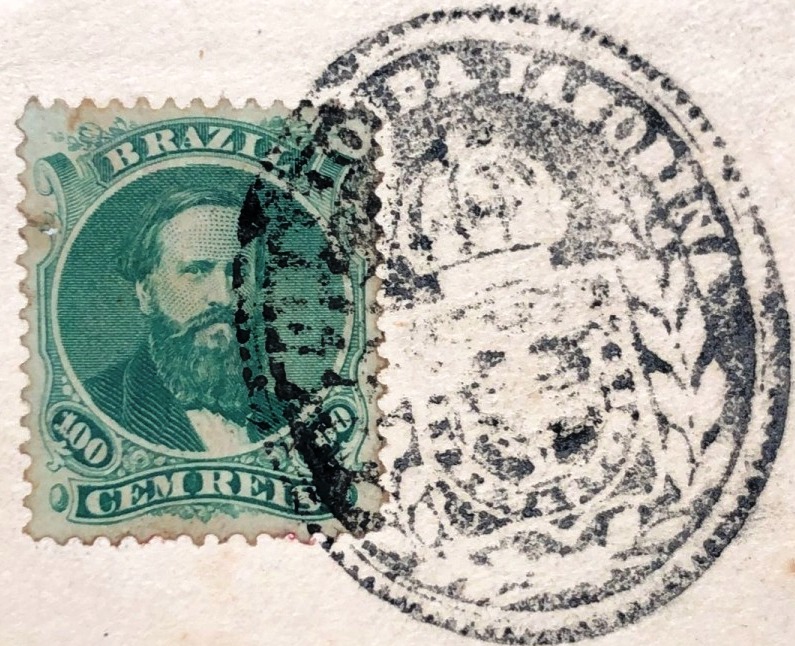
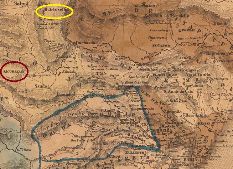
Founded in 1677, the Freguesia de Sto. Antonio da Jacobina was originally located in N. Sra. das Neves do Say, today Município de Senhor do Bonfim, 390 km north-west of the colonial capital Salvador da Bahia (yellow oval in the map above). It was elevated to a Vila in August 1720 and in February 1724 moved approx. 100 km south to the north bank of the Itapicuru-Mirim, where the village of Bom Jesus da Glória was located (red oval in the map above). Jacobina has been a town since July 1880.
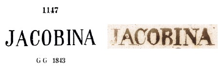
Two creation dates were found for the local post office. Firstly in March 1832, as Nova Monteiro writes in Administrações e Agencias Postaes do Brasil Imperio (Brasil Filatelico/RJ, 1934-5; reprint SPP 1994-1999). Then in 1868, as can be seen from the Directory of Imperial Post Offices (Tabella das Agencias do Correio do Imperio, Rio de Janeiro, 1885). As the agency is still listed in the postal guide (Guia do Correio do Brasil) of 1857, it was subsequently closed.
The oldest postmark to date is the pre-philatelic JBA-0420a, which also exists in brown. However, the illustration in P. Ayres’ Catálogo de Carimbos Brasil-Império (S. Paulo, 1937, 1942) should be corrected; as another image shows (D. Feldman Auctions):
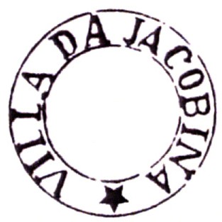
Then came JBA-0420b. This cancel was previously seen without a star at the bottom, which was corrected in the Catálogo ilustrado dos carimbos sobre os olhos-de-boi (Porto Alegre, 2017) by Henrique B. Ferreira:
JBA-0420b (HBF) 1843ff-1850ff
After 1866, a cancel with the imperial seal JBA-0420c (fig. Felipe Piccinini) was used:
JBA-0420c (FP) 1866ff
This was followed by the French type JBA-0420d (fig. Roberto Assef Jr.):
JBA-0420d (RA) 1876ff-1881ff
At the end of the Empire, JBA-0420e also appeared (ill. Felipe Piccinini):
JBA-0420e (FP) 1877ff-1893
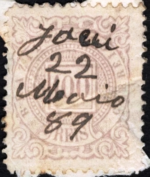
From the Fuad Ferreira Fo. collection comes a mute cancel in blue from the imperial Jacobina:
1879 (FF)Villiers de l’Ile Adam: Carta (…) da Provincia da Bahia, 1848
Die 1677 gegründete Freguesia de Sto. Antonio da Jacobina lag ursprünglich in N. Sra. das Neves do Say, im heutigen Município de Senhor do Bonfim, 390 km nordwestlich der Kolonialhauptstadt Salvador da Bahia (gelb auf der Karte oben). Sie wurde im August 1720 zur Vila erhoben und im Februar 1724 ca. 100 km südlich an das Nordufer des Itapicuru-Mirim verlegt, wo sich das Dorf Bom Jesus da Glória befand (rot auf der Karte). Seit Juli 1880 ist Jacobina eine Stadt.
Für das örtliche Postamt wurden zwei Gründungsdaten gefunden. Zuerst im März 1832, wie Nova Monteiro in Administrações e Agencias Postaes do Brasil Imperio (Brasil Filatelico/RJ, 1934-5; Nachdruck SPP 1994-1999) schreibt. Dann 1868, wie aus dem Verzeichnis der kaiserlichen Postämter (Tabella das Agencias do Correio do Imperio, Rio de Janeiro, 1885) hervorgeht. Da die Agentur noch im Postführer (Guia do Correio do Brasil) von 1857 aufgeführt ist, wurde sie danach geschlossen.
Der bisher älteste Poststempel ist der vorphilatelistische JBA-0420a, der auch in Braun existiert. Die Abbildung in P. Ayres‘ Catálogo de Carimbos Brasil-Império (S. Paulo, 1937, 1942) muss jedoch korrigiert werden; wie das andere Bild zeigt (D. Feldman Auctions):
Dann kam JBA-0420b. Dieser Stempel wurde bisher ohne den Stern unten gesehen, was durch den Catálogo ilustrado dos carimbos sobre os olhos-de-boi (Porto Alegre, 2017) von Henrique B. Ferreira korrigiert werden konnte:
JBA-0420b (HBF) 1843ff-1850ff
Nach 1866 wurde der Stempel mit dem kaiserlichen Siegel JBA-0420c (Abb. Felipe Piccinini) verwendet:
JBA-0420c (FP) 1866ff
Es folgte der französische Typ JBA-0420d (Abb. Roberto Assef Jr.):
JBA-0420d (RA) 1876ff-1881ff
Am Ende des Kaiserreichs erschien auch JBA-0420e (Abb. Felipe Piccinini):
JBA-0420e (FP) 1877ff-1893
Aus der Sammlung Fuad Ferreira Fo. kennen wir auch einen stummen Stempel in Blau aus der kaiserlichen Jacobina:
Colton & Colton: Provincia do Rio de Janeiro, 1880
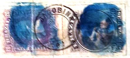
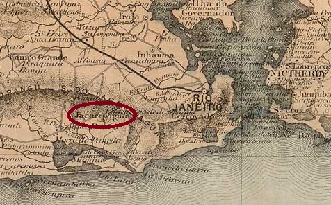
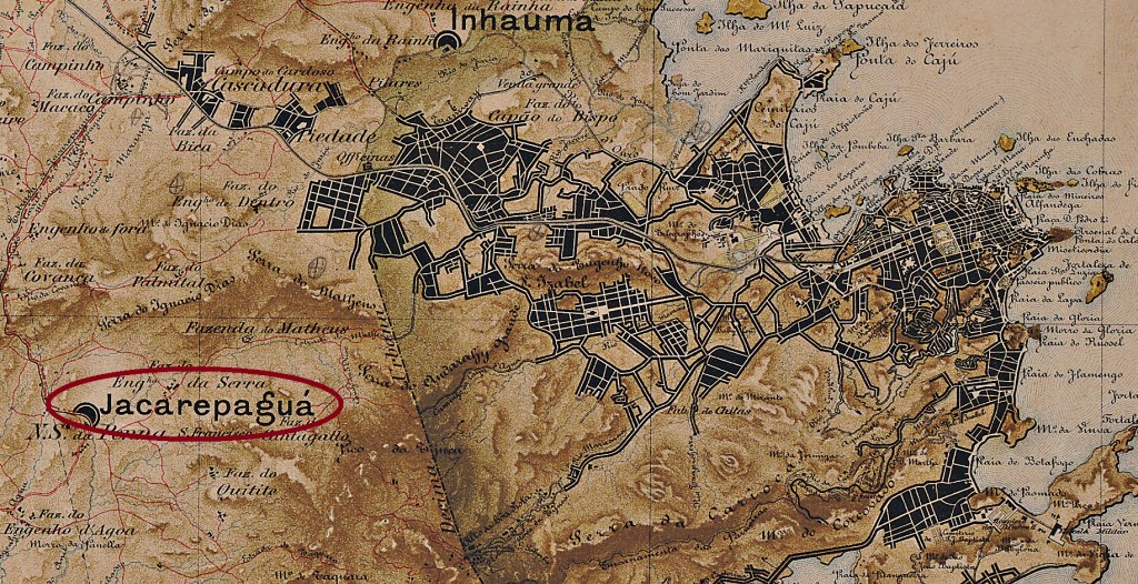
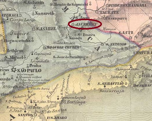
The Freguesia de N. Sra. de Loreto de Jacarepaguá, located 30 kilometres west of the capital Rio de Janeiro and since July 1981 an administrative district (Região Administrativa) of the Município do Rio de Janeiro, has been documented since 1661. The place name comes from the Tupi-guarani and means bay of crocodiles.
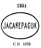
According to the list of imperial post offices (Tabella das Agencias do Correio do Imperio, Rio de Janeiro, 1885), there had been a post office there since 1878, which was closed around 1937 according to P. Novaes (agenciaspostais.com.br). The oldest postmark is JMN-2315a, which was given the no. 1334 by P. Ayres in Catálogo de Carimbos Brasil-Império (S. Paulo, 1937, 1942):
JMN-2315a (P.A. 1334) 1878ff
This was followed by the double circle JMN-2315b (fig. R. Koester, in Carimbologia XXV):
JMN-2315b (RK) 1882-1885Mappa do Municipio Neutro, ca. 1880
Seit 1661 ist die Freguesia de N. Sra. de Loreto de Jacarepaguá, 30 km westlich der Hauptstadt Rio de Janeiro gelegen und seit Juli 1981 ein Verwaltungsbezirk (Região Administrativa) des Município do Rio de Janeiro, bezeugt. Der Ortsname kommt aus dem Tupi-guarani und bedeutet Bucht der Krokodile.
Wie aus dem Verzeichnis der kaiserlichen Postämter (Tabella das Agencias do Correio do Imperio, Rio de Janeiro, 1885) hervorgeht, gab es dort seit 1878 ein Postamt, das nach P. Novaes (agenciaspostais.com.br) um 1937 geschlossen wurde. Der älteste Poststempel ist JMN-2315a, der von P. Ayres in Catálogo de Carimbos Brasil-Império (S. Paulo, 1937, 1942) die Nr. 1334 erhielt:
JMN-2315a (P.A. 1334) 1878ff
Es folgte der Doppelkreis JMN-2315b (Abb. R. Koester, in Carimbologia XXV):
Villiers de l’Ile Adam: Carta (…) da Provincia de São Paulo, 1847
Other names: Conceição da Parahyba
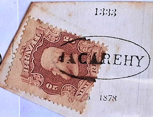
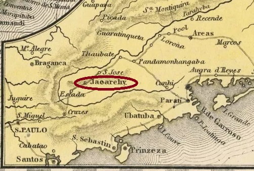
A settlement N. Sra. da Conceição da Parahyba, which belonged to the Vila de Mogy das Cruzes and was located on the east bank of the Paraíba do Sul, 80 km north-east of the later provincial capital of São Paulo, has been documented since 1652. It was probably renamed Conceição do Jacarehy when it was elevated to a vila in November 1653 and has been a town since April 1849 (as it is spelt today).
Three periods of operation have been established for the local post office. The first is said to have started in September 1827, according to the regional press:
O Farol Paulistano, 01/09/1827
Accordingly, the post office was founded by the government and the economic elite of the province of São Paulo on their own initiative. The imperial postal service began in 1844, as can be read in the directory of imperial post offices (Tabella das Agencias do Correio do Imperio, Rio de Janeiro, 1885). The third founding date of the postal agency in December 1864 was given by the philatelist Mário Celso Orsi Jr, unfortunately without a source.
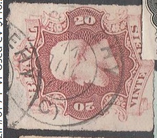
The oldest postmarks to date are similar, as can be seen. JSP-0680a (fig. Henrique B. Ferreira) also occurs in brown and red, while JSP-0680b in P. Ayres Catálogo de Carimbos Brasil-Império (S. Paulo, 1937, 1942) received the no. 1146:
Then came JSP-0680c, also known by P. Ayres, this time under no. 1333:
JSP-0680c (P.A. 1333) 1850ff-1878ff
This was followed by the French type JSP-0680d (coll. Fuad Ferreira Fo.):
JSP-0680d (FF) 1869-1884
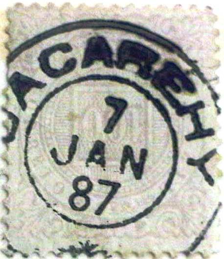
At the end of the Empire, the double circle JSP-0680e (fig. R. Koester in Carimbologia XXV) with the typical ornament at the bottom also appeared:
JSP-0680e (RK) 1885-1895
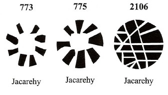
James Dingler and Klerman W. Lopes have listed three mute cancels of Jacarehy in Mute Cancellations of the Brazil Empire/Carimbos Mudos do Brasil Império (Brazil Philatelic Association, Rio de Janeiro, 2000):
BPA 773 – 775 (1866ff-1884) – 2106
Another mute cancellation is shown by Rodrigo Baldassare:
1878 (RB)Samuel A. Mitchell: Map of the Brazil, 1854
Andere Namen: Conceição da Parahyba
Seit 1652 ist eine Siedlung N. Sra. da Conceição da Parahyba belegt, die zur Vila de Mogy das Cruzes gehörte und am Ostufer des Paraíba do Sul, 80 km nordöstlich der späteren Provinzhauptstadt São Paulo, lag. Die Umbenennung in Conceição do Jacarehy erfolgte wahrscheinlich bei der Erhebung zur Vila im November 1653. Seit April 1849 ist Jacareí (wie es heute geschrieben wird) eine Stadt.
Für das örtliche Postamt wurden drei Betriebszeiten festgestellt. Die erste soll im September 1827 begonnen haben, wie aus der regionalen Presse hervorgeht:
O Farol Paulistano, 01.09.1827
Demnach wurde die Post von der Regierung und der wirtschaftlichen Elite der Provinz São Paulo in Eigenregie gegründet. 1844 begann der kaiserliche Postdienst, wie im Verzeichnis der kaiserlichen Postämter (Tabella das Agencias do Correio do Imperio, Rio de Janeiro, 1885) nachzulesen ist. Das dritte Gründungsdatum der Postagentur im Dezember 1864 wurde von dem Philatelisten Mário Celso Orsi Jr. angegeben, leider ohne Quellenangabe.
Die bisher ältesten Poststempel ähneln sich, wie man sieht. JSP-0680a (Abb. Henrique B. Ferreira) kommt auch in braun und rot vor, während JSP-0680b in P. Ayres Catálogo de Carimbos Brasil-Império (S. Paulo, 1937, 1942) die Nr. 1146 erhielt:
Danach kam JSP-0680c, ebenfalls durch P. Ayres, diesmal unter Nr. 1333, bekannt:
JSP-0680c (P.A. 1333) 1850ff-1878ff
Es folgte der französische Typ JSP-0680d (Samml. Fuad Ferreira Fo.):
JSP-0680d (FF) 1869-1884
Am Ende des Kaiserreichs erschien auch der Doppelkreis JSP-0680e (Abb. R. Koester in Carimbologia XXV) mit dem typischen Ornament unten:
JSP-0680e (RK) 1885-1895
James Dingler und Klerman W. Lopes haben in Mute Cancellations of the Brazil Empire/Carimbos Mudos do Brasil Império (Brazil Philatelic Association, Rio de Janeiro, 2000) drei stumme Stempel von Jacarehy aufgeführt:
BPA 773 – 775 (1866ff-1884) – 2106
Ein weiterer stummer Stempel zeigt Rodrigo Baldassare:
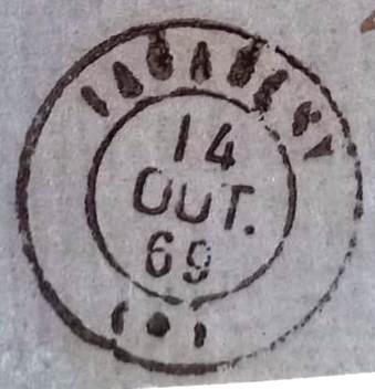
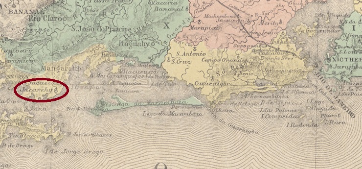
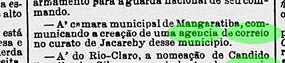
This curato of the Vila de Mangaratiba, idyllically situated on the beach, 120 kilometres west of the capital Rio de Janeiro, had existed since October 1856. In January 1859, it became the Freguesia de N. Sra. da Conceição de Jacarehy, which has been the Distrito de Conceição de Jacareí in the Município de Mangaratiba since December 1943.
The establishment of a local post office was decided in September 1858, as reported in the Rio press:
Correio Mercantil, 15/10/1858
The oldest postmark is the very rare JRJ-0680a (collect. Fuad Ferreira Fo.):
JRJ-0680a (FF) 1869
At that time, the stamps there were also cancelled by hand, as the example of the collector above shows:
1869 (FF)
Its successor has yet to be definitively confirmed, as R. Koester writes in Carimbologia XXV that the cancel JRJ-0680b (here an image from the Internet) comes from Jacarehy in São Paulo (JSP-0680):
JRJ-0680b (EB) 1877-1878
According to Koester, the lower (C) should mean Cidade (city). However, this distinguishing feature would only have made sense if the city status had been new or to distinguish Jacarehy in S. Paulo from the smaller Jacarehy in the province of Rio de Janeiro. However, Jacarehy in São Paulo had already been a town since April 1849, while Jacarehy in Rio became a curato in 1856 (as also legible on JRJ-0680a). This means that the designation as a city would have appeared on the postmark with a delay of almost 30 years.
Since the post office in the small Jacarehy of Rio was also at least 30 years younger than its namesake in São Paulo, it would be more conceivable that the (C) stands for Curato, precisely to distinguish it from the larger Jacarehy. The small number of existing examples of JRJ-0680b and the fact that two other postmarks (JSP-0680c and JSP-0680d) were used in Jacarehy/SP in 1877-1878 indirectly support that JRJ-0680b originates from Jacarehy in Rio.
Colton & Colton: Prinvicia do Rio de Janeiro, 1866
Andere Namen: Conceição de Jacareí (1943)
Seit Oktober 1856 bestand dieser Curato der idyllisch am Strand gelegenen Vila de Mangaratiba, 120 km westlich der Hauptstadt Rio de Janeiro. Im Januar 1859 wurde daraus die Freguesia de N. Sra. da Conceição de Jacarehy, die seit Dezember 1943 der Distrito de Conceição de Jacareí im Município de Mangaratiba ist.
Die Einrichtung eines örtlichen Postamtes wurde im September 1858 beschlossen, wie die Presse von Rio berichtete:
Correio Mercantil, 15.10.1858
Der älteste Poststempel ist der sehr seltene JRJ-0680a (Samml. Fuad Ferreira Fo.):
JRJ-0680a (FF) 1869
Damals wurden die Marken dort auch von Hand entwertet, wie das Beispiel des obigen Sammlers zeigt:
1869 (FF)
Sein Nachfolger muss noch endgültig bestätigt werden, denn R. Koester schreibt in Carimbologia XXV, dass folgender Stempel JRJ-0680b (hier eine Abbildung aus dem Internet) aus Jacarehy in São Paulo (JSP-0680) stammt:
JRJ-0680b (EB) 1877-1878
Nach Koester sollte das untere (C) Cidade (Stadt) bedeuten. Dieses Unterscheidungsmerkmal hätte aber nur Sinn gemacht, wenn der Stadtstatus neu gewesen wäre oder zur Unterscheidung von dem kleinen Jacarehy in der Provinz Rio de Janeiro. Jacarehy in São Paulo war aber bereits seit April 1849 eine Stadt, während Jacarehy in Rio 1856 ein Curato wurde (wie auch auf JRJ-0680a vermerkt). Damit wäre die Bezeichnung als Stadt mit einer Verspätung von ca. 30 Jahren auf dem Stempel erschienen.
Da das Postamt im kleinen Jacarehy von Rio auch mindestens 30 Jahre jünger war als sein Namensvetter in São Paulo, wäre es eher denkbar, dass das (C) für Curato steht, eben um es vom größeren Jacarehy zu unterscheiden. Die geringe Anzahl vorhandener Exemplare von JRJ-0680b sowie die Tatsache, dass 1877-1878 zwei weitere Poststempel (JSP-0680c und JSP-0680d) in Jacarehy/SP verwendet wurden, sprechen indirekt dafür, dass JRJ-0680b tatsächlich aus Jacarehy in Rio stammt.
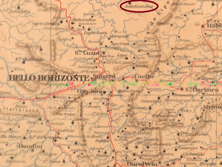
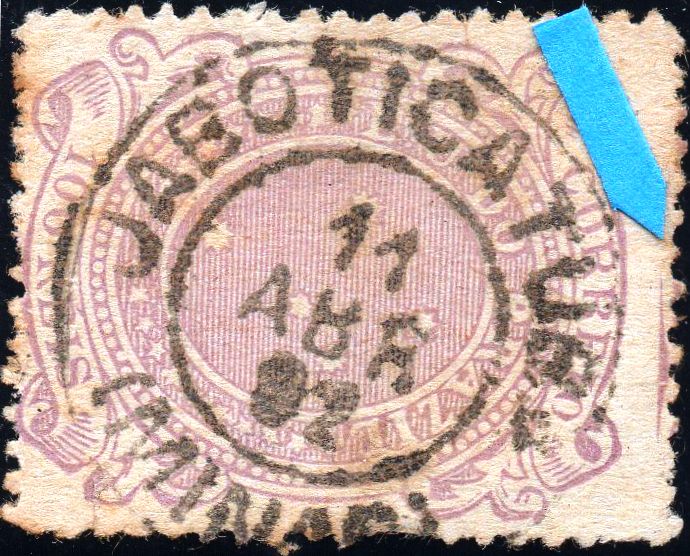
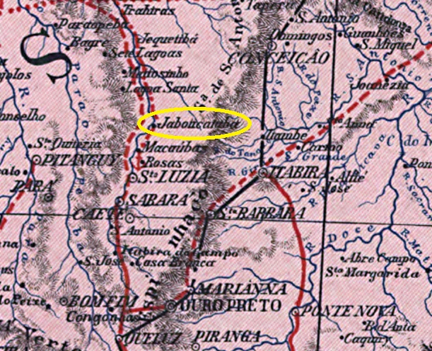
The settlement of Curato do Ribeirão do Raposo, which had existed since 1841, belonged to the Vila de Sabará and was located 160 kilometres north of the provincial capital of Ouro Preto. In June 1858 it became the Freguesia de N. Sra. da Conceição de Jaboticatubas, then belonging to the Vila de Caeté and changed in November 1878 the Vila de Santa Luzia. Jaboticatubas has been an independent município since December 1938. The name comes from the Tupi-guarani and means many Jabuticabeiras.
Paula Sobrinho (História Postal de Minas Gerais, Belo Horizonte, 1997) and R. Koester (Carimbologia XXV) agree that there has been a post office there since November 1883. The only imperial postmark to date is JMG-1395a (image from the Internet):
JMG-1395a (EB) 1888-1892Carta da Republica dos Estados Unidos do Brazil, 1892
Andere Namen: Jaboticatubas, Ribeirão do Raposo
Die seit 1841 bestehende Siedlung Curato do Ribeirão do Raposo gehörte zur Vila de Sabará und lag 160 km nördlich der Provinzhauptstadt Ouro Preto. Im Juni 1858 wurde sie zur Freguesia de N. Sra. da Conceição de Jaboticatubas, dann zur Vila de Caeté und im November 1878 zur Vila de Santa Luzia. Seit Dezember 1938 ist Jaboticatubas ein unabhängiges Município. Der Name stammt aus dem Tupi-guarani und bedeutet viele Jabuticabeiras.
Paula Sobrinho (História Postal de Minas Gerais, Belo Horizonte, 1997) und R. Koester (Carimbologia XXV) sind sich einig, dass es dort seit November 1883 ein Postamt gab. Der bisher einzige kaiserliche Poststempel ist JMG-1395a (Abbildung aus dem Internet):