Categories
Carimbologia H-L

Januaria, Minas Gerais (JMG-1415)

Atlas do Imperio do Brasil, 1868

Other names: Other names: Brejo do Amparo, Brejo do Salgado, Porto do Salgado

See also Villa Januária (VMG-1416)

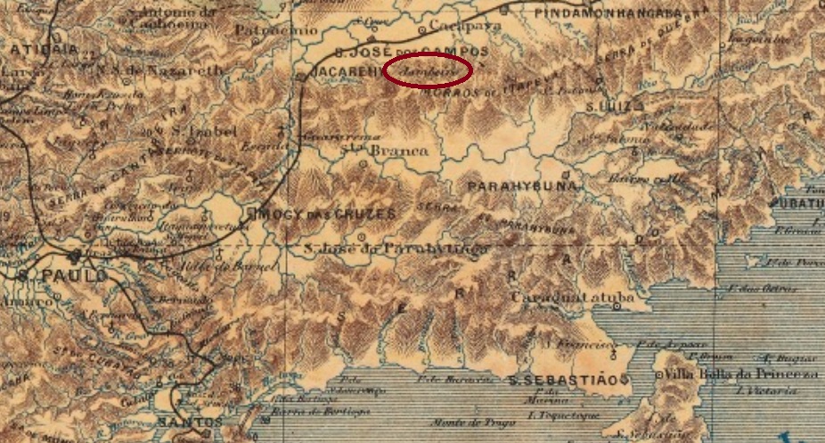
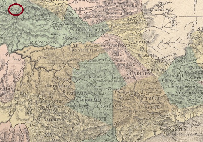
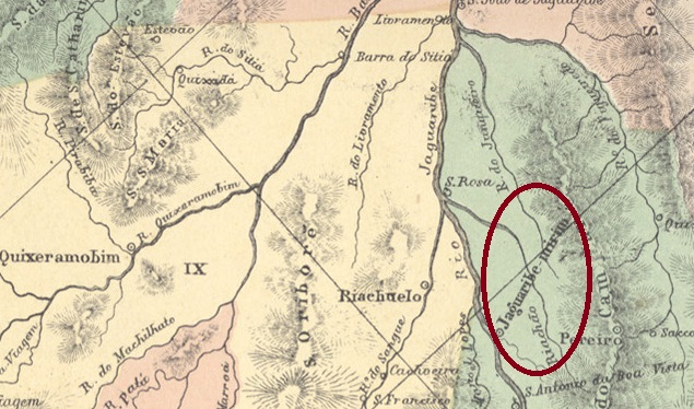
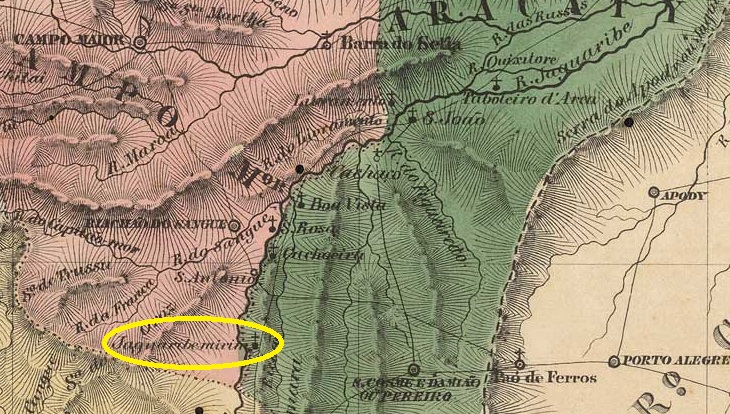
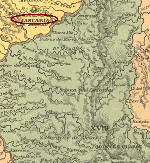
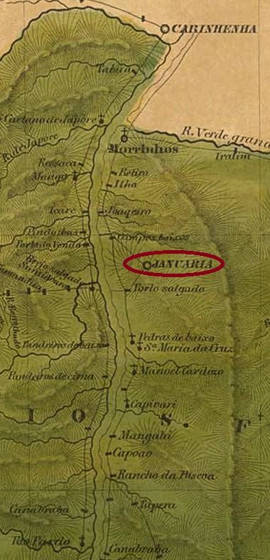
This locality also causes some headaches for researchers, as it has not only been renamed many times, but can also be seen in different places on old maps. What seems certain is that from January 1811 it was the old freguesia of Brejo do Amparo, which belonged to the Vila of Paracatu and was initially located on the right bank of the São Francisco River, about 680 km north of the later provincial capital of Ouro Preto. In June 1833, the place was elevated to a vila, called Villa Januaria de N. Sra. do Amparo do Brejo do Salgado. The Salgado is a tributary of the left bank of the São Francisco, and accordingly the vila was henceforth to be seen on the opposite side of the river. In October 1860, the Vila became a town called Porto do Salgado, but by September 1871, the Município was called Brejo do Amparo, as before. Finally, since September 1884, the municipality has been called Januária, after a daughter of Emperor Pedro I. Presumably, this was the Solomonic solution after a long name dispute between right- and left-bank inhabitants.

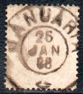
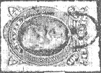
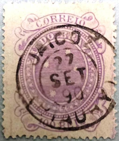
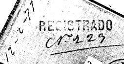
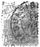
At least as far as the origin of the post office is concerned, there is agreement among researchers. Nova Monteiro (Administrações e Agencias Postaes do Brasil Imperio, in Brasil Filatelico/RJ, 1934-5; Reprint SPP 1994-1999), Paula Sobrinho (História Postal de Minas Gerais, Belo Horizonte, 1997) and Reinhold Koester (Carimbologia XXV) unanimously name October 1833. The oldest postmark is VMG-1416a; it also occurs in sepia with dates of use from 1836 to at least 1850 and has already been presented in the RHM catalogue under P-MG-32:

VMG-1416a (RHM P-MG-32) 1836-1850ff

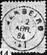
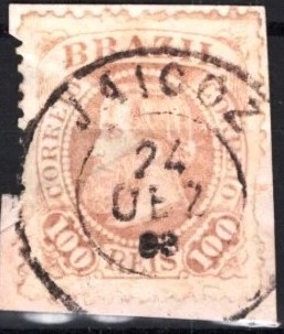
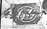
JMG-1415b (fig. Felipe Piccinini) did not appear until around 1887, which suggests that another postmark was used in the meantime, the image of which is still missing:

JMG-1415b (FP) 1887-1889
Villiers de l’Ile Adam: Carta (…) da Provincia de Minas Geraes, 1849

Andere Namen: Brejo do Amparo, Brejo do Salgado, Porto do Salgado

Siehe auch Villa Januária (VMG-1416)

Auch diese Ortschaft bringt einige Kopfzerbrechen für die Forscher, da sie nicht nur oft umbenannt wurde, sondern auch an verschiedenen Stellen auf alten Karten zu sehen ist. Sicher scheint es zu sein, sie war ab Januar 1811 die alte Freguesia von Brejo do Amparo, die der Vila von Paracatu gehörte und zunächst am rechten Ufer des Flusses São Francisco lag, etwa 680 km nördlich der späteren Provinzhauptstadt Ouro Preto entfernt. Im Juni 1833 wurde der Ort zu einer Vila erhoben, die Villa Januaria de N. Sra. do Amparo do Brejo do Salgado hieß. Nun ist der Salgado ein Nebenfluss des linken Ufers vom São Francisco, und dementsprechend war die Vila fortan auf der gegenüberliegenden Flussseite zu sehen. Im Oktober 1860 wurde aus der Vila eine Stadt mit Namen Porto do Salgado, aber schon im September 1871 hieß der Município Brejo do Amparo, wie früher. Schließlich seit September 1884 heißt die Gemeinde Januária, nach einer Tochter des Kaisers Pedro I. Vermutlich war das die salomonische Lösung nach einem langen Namensstreit zwischen Rechts- und Linksufereinwohnern.

Zumindest was die Entstehung des Postamts betrifft, herrscht Einigkeit unter den Forschern. Nova Monteiro (Administrações e Agencias Postaes do Brasil Imperio, in Brasil Filatelico/RJ, 1934-5; Reprint SPP 1994-1999), Paula Sobrinho (História Postal de Minas Gerais, Belo Horizonte, 1997) und Reinhold Koester (Carimbologia XXV) nennen dafür einstimmig den Oktober 1833. Der älteste Poststempel ist VMG-1416a; er kommt auch in sepia mit Verwendungsdaten von 1836 bis in die 50er Jahre vor und wurde bereits im RHM-Katalog unter P-MG-32 vorgestellt:

VMG-1416a (RHM P-MG-32) 1836-1850ff

Erst ab ca. 1887 erschien JMG-1415b (Abb. Felipe Piccinini), was vermuten lässt, dass zwischenzeitlich ein weiterer Poststempel verwendet wurde, dessen Abbildung noch fehlt:

JMG-1415b (FP) 1887-1889
Categories
Carimbologia H-L

Jambeiro, São Paulo (JSP-0710)

Carlos D. Rath: Provincia de São Paulo, 1886

Other names: N. Sra. das Dores de Capivary

The Freguesia de N. Sra. das Dores de Capivary had existed since April 1872. It belonged to the Vila de Caçapava and was located on the Capivari, 120 kilometres east of the provincial capital of São Paulo. In March 1876, it was elevated to a Vila, but changed its name to Jambeiro in May of the following year, presumably to avoid confusion with the other Vila de Capivary in São Paulo. Jambeiro has been a town since July 1898. The name comes from a beautiful tree from the myrtle family (Myrtaceae), which bears juicy, sweet fruit.

Syzygium malaccense (Photo: paraisodasarvores.com.br)

R. Koester writes in Carimbologia XXV that there has been a post office there since around 1878. In fact, it must have already existed in July of the previous year, as can be seen from the regional press:

Correio Paulistano, 17/08/1877

The oldest postmark is the French type JSP-0710a (fig. R. Koester, op. cit.)

JSP-0710a (RK) 1877ff-1884

It was followed by the double circle JSP-0710b (fig. Koester):

JSP-0710b (RK) 1885-1886
J.M. Ribeiro Lisboa: Provincia de São Paulo, 1884

Andere Namen: N. Sra. das Dores de Capivary

Die Freguesia de N. Sra. das Dores de Capivary bestand seit April 1872. Sie gehörte zur Vila de Caçapava und lag am Ufer des Capivari, 120 Kilometer östlich der Provinzhauptstadt São Paulo. Im März 1876 wurde sie zur Vila erhoben, änderte aber im Mai des folgenden Jahres ihren Namen in Jambeiro, vermutlich um Verwechslungen mit der anderen Vila de Capivary in São Paulo zu vermeiden. Jambeiro ist seit Juli 1898 eine Stadt. Der Name stammt von einem schönen Baum aus der Familie der Myrtengewächse (Myrtaceae), der saftige, süße Früchte trägt.

Syzygium malaccense (Foto: paraisodasarvores.com.br)

R. Koester schreibt in Carimbologia XXV, dass es dort seit etwa 1878 ein Postamt gibt. Tatsächlich muss es aber schon im Juli des Vorjahres bestanden haben, wie aus der regionalen Presse hervorgeht:

Correio Paulistano, 17/08/1877

Der älteste Poststempel ist der französische Typ JSP-0710a (Abb. R. Koester, op. cit.)

JSP-0710a (RK) 1877ff-1884

Ihm folgte der Doppelkreis JSP-0710b (Abb. Koester):

JSP-0710b (RK) 1885-1886
Categories
Carimbologia H-L

Jaicoz, Piauí (JPI-0080)

Villiers de l’Ile Adam: Carta (…) da Provincia do Piauhy, 1850

Other spelling: Jaicós

The Jaicós were members of an indigenous tribe in the hinterland of the Capitania de Piauí, after whom the Freguesia de N. Sra. das Mercês de Jaicoz was named in September 1801. It belonged to the Vila de Oeiras and was located on the west bank of the Bonsucesso, almost 400 kilometres south-east of the later provincial capital Teresina. In July 1832 it was elevated to the status of a Vila and since December 1889 Jaicós, as it is spelt today, has been a town.

R. Koester writes in Carimbologia XXV that there had been a post office there since 1882. However, this is probably either a mistake or a reopening, as Nova Monteiro gives a much earlier date – September 1817 – in Administrações e Agencias Postaes do Brasil Imperio (Brasil Filatelico/RJ, 1934-5; reprint SPP 1994-1999). This postal agency is then also listed in the postal guides of 1857 and 1880 and appears repeatedly in the regional press between 1839 and 1874.

Two postmarks were found for the 19th century. The rare JPI-0080b (fig. R. Koester, op. cit.) is shown in an unfortunately poor quality:

JPI-0080b (RK) 1877ff

It was followed by the double circle JPI-0080c (image by Felipe Piccinini):

JPI-0080c (FP) 1883

Later came JPI-0080d (collect. Fuad Ferreira Fo.):

JPI-0080d (FF) 1890-1894
Atlas do Imperio do Brasil, 1868

Textaktualisierung vom 2. Juli 2025

Andere Schreibweise: Jaicós

Die Jaicós waren Angehörige eines indigenen Stammes im Hinterland der Capitania de Piauí, nach dem im September 1801 die Freguesia de N. Sra. das Mercês de Jaicoz benannt wurde. Sie gehörte zur Vila de Oeiras und lag am Westufer des Bonsucesso, knapp 400 km südöstlich der späteren Provinzhauptstadt Teresina. Im Juli 1832 erfolgte die Erhebung zur Vila und seit Dezember 1889 ist Jaicós, wie es heute geschrieben wird, eine Stadt.

R. Koester schreibt in Carimbologia XXV, dass es dort seit 1882 ein Postamt gab. Das dürfte aber entweder ein Irrtum oder eine Wiedereröffnung sein, denn Nova Monteiro gibt in Administrações e Agencias Postaes do Brasil Imperio (Brasil Filatelico/RJ, 1934-5; Reprint SPP 1994-1999) dafür ein viel früheres Datum – September 1817 (NM) – an. Diese Postagentur ist dann auch in den Postführern von 1857 und 1880 verzeichnet und taucht zwischen 1839 und 1874 wiederholt in der regionalen Presse auf.

Für das 19. Jahrhundert wurden zwei Poststempel gefunden. Der seltene JPI-0080b (Abb. R. Koester, op. cit.) ist in einer leider schlechten Abbildung dargestellt:

JPI-0080b (RK) 1877ff

Ihm folgte der Doppelkreis JPI-0080c (Abb. Felipe Piccinini):

JPI-0080c (FP) 1883

Danach kam JPI-0080d (Samml. Fuad Ferreira Fo.):

JPI-0080d (FF) 1890-1894
Categories
Carimbologia H-L

Jahu, São Paulo (JSP-0705)

J.M. Ribeiro Lisboa: Provincia de São Paulo, 1884

Other spelling: Juhu

In March 1859, the Freguesia de N. Sra. do Patrocínio do Jahu was founded on the south bank of the Jaú in the Vila de Brotas, 300 kilometres northwest of the provincial capital of São Paulo. It was declared a vila in April 1866 and a town in February 1889. The indigenous name refers to a large catfish from the Pimelodidae family:

Zungaro zungaro (Humboldt & Valenciennes, 1821)

According to the São Paulo press, in December 1867 it was decided to set up a post office in the Vila:

Diario de São Paulo, 09.01.1868

The first postmark was probably not delivered on time, as early hand cancellations are known:

1867ff (FF)

The beautiful double circle JSP-0705a (fig. Mário Celso Orsi Jr.), which is also available in blue and green, did not appear until the 70s:

JSP-0705a (MO) 1875-1880

Shortly afterwards, JSP-0705b also appeared, with the incorrect spelling JUHU (fig. R. Koester, in Carimbologia XXV):

JSP-0705b (RK) 1878

The French type JSP-0705c (fig. Felipe Piccinini) was also used in the late imperial period:

JSP-0705c (FP) 1885-1892

The railway postmark JSP-0706a (fig. Koester, op. cit.) came at about the same time:

JSP-0706a (RK) 1891

Koester also showed a registered postmark from the 70s:

1877 (RK)

James Dingler and Klerman W. Lopes presented in Mute Cancellations of the Brazil Empire / Carimbos Mudos do Brasil Império (Brazil Philatelic Association, Rio de Janeiro, 2000) the mute cancellation with no. 4087:

BPA 4087

Further mute cancels of Jahú were presented by R. Koester:

1878 (RK)
1878 (RK)
Atlas do Imperio do Brasil, 1868

Andere Schreibweise: Juhu

Im März 1859 wurde die Freguesia de N. Sra. do Patrocínio do Jahu am Südufer des Jaú in der Vila de Brotas, 300 km nordwestlich der Provinzhauptstadt São Paulo, gegründet. Sie wurde im April 1866 zur Vila und im Februar 1889 zur Stadt ernannt. Der indigene Name bezeichnet einen großen Wels aus der Familie Pimelodidae:

Zungaro zungaro (Humboldt & Valenciennes, 1821)

Wie die Presse von São Paulo berichtet, wurde im Dezember 1867 beschlossen, in der Vila ein Postamt einzurichten:

Diario de São Paulo, 09.01.1868

Vermutlich wurde der erste Poststempel nicht rechtzeitig geliefert, da frühe Handentwertungen bekannt sind:

1867ff (FF)

Erst in den 70er Jahren erschien der schöne Doppelkreis JSP-0705a (Abb. Mário Celso Orsi Jr.), den es auch in blau und grün gibt:

JSP-0705a (MO) 1875-1880

Kurz danach erschien auch JSP-0705b, mit der falschen Schreibweise JUHU (Abb. R. Koester, in Carimbologia XXV):

JSP-0705b (RK) 1878

In der späten Kaiserzeit wurde auch der französische Typ JSP-0705c (Abb. Felipe Piccinini) verwendet:

JSP-0705c (FP) 1885-1892

Etwa zur gleichen Zeit kam der Bahnpoststempel JSP-0706a (Abb. Koester, op. cit.) hinzu:

JSP-0706a (RK) 1891

Koester zeigte auch einen Einschreibstempel aus den 70er Jahren:

1877 (RK)

James Dingler und Klerman W. Lopes zeigten in Mute Cancellations of the Brazil Empire / Carimbos Mudos do Brasil Império (Brazil Philatelic Association, Rio de Janeiro, 2000) den stummen Stempel mit Nr. 4087:

BPA 4087

Weitere stumme Stempel von Jahú wurden von R. Koester präsentiert:

1878 (RK)
1878 (RK)
Categories
Carimbologia H-L

Jaguary, Minas Gerais (JMG-1410)

Villiers de l’Ile Adam: Carta (…) da Provincia de Minas Geraes, 1849

Other names: Camanducaia (1925)

The Freguesia de Camanducaia on the north bank of the river of the same name, 500 kilometres southwest of the later provincial capital Ouro Preto, had existed since 1775. In March 1840 it became Vila de Jaguary (River of the Jaguars, in Tupi-guarani) and in July 1868 it was elevated to the status of a town. In September 1930, the original place name Camanducaia returned, probably to distinguish it from other Jaguaris (as it is spelt today). The meaning of the word Camanduacaia is not clear; some believe it means cooked beans, others are in favour of the translation ‘fireplace for hunting’.

In July 1847, it was decided to establish a post office in Jaguary, according to the report of the Imperial Ministry:

Relatorio do Ministerio do Imperio, 1847

R. However, Koester shows in Carimbologia XXV that postal routes were routed via Jaguary (then Camanducaia) at least as early as 1835, as a tax control office (Registro) still existed there.

Initially, the stamps were cancelled by hand, as R. Koester (op. cit.) shows:

1849 (RK)

Then came the unfortunately poorly legible cancel JMG-1410a (fig. Koester). The inscription would read ‘Correio de Jaguary’:

JMG-1410a (RK) 1867

Later, the double circle JMG-1410b (ill. Claudio Neumann) was added, which also exists in blue:

JMG-1410b (CN) 1879-1891

According to Koester, the following mute cancel no. 251 in P. Ayres (Catálogo de Carimbos Brasil-Império, S. Paulo, 1937, 1942) also comes from Jaguary:

P.A. 251 (BPA 1328) 1866ff-1879

At the beginning of the Republic, cancellations were again made by hand, as the following image shows (ill. Cláudio Coelho):

1895 (CC)
Atlas do Imperio do Brasil, 1868

Andere Namen: Camanducaia (1925)

Seit 1775 bestand die Freguesia de Camanducaia am Nordufer des gleichnamigen Flusses, 500 km südwestlich der späteren Provinzhauptstadt Ouro Preto. Im März 1840 wurde sie zur Vila de Jaguary (Fluss der Jaguare, auf Tupi-guarani) und im Juli 1868 zur Stadt erhoben. Im September 1930 kehrte der ursprüngliche Ortsname Camanducaia zurück, wahrscheinlich um sich von anderen Jaguaris (wie es heute geschrieben wird) zu unterscheiden. Die Bedeutung des Wortes Camanduacaia ist nicht eindeutig; einige glauben, dass es gekochte Bohnen bedeutet, andere sind für die Übersetzung “Feuerstelle für die Jagd”.

Im Juli 1847 wurde beschlossen, in Jaguary ein Postamt einzurichten, wie aus dem Bericht des kaiserlichen Ministeriums hervorgeht:

Relatorio do Ministerio do Imperio, 1847

R. Koester weist jedoch in Carimbologia XXV nach, dass zumindest schon 1835 Postrouten über Jaguary (damals Camanducaia) geführt wurden, da dort noch eine Steuerkontrollstelle (Registro) existierte.

Anfangs wurden die Marken noch von Hand entwertet, wie R. Koester (op. cit.) zeigt:

1849 (RK)

Dann kam der leider schlecht lesbare Stempel JMG-1410a (Abb. Koester). Die Inschrift soll “Correio de Jaguary” lauten:

JMG-1410a (RK) 1867

Später kam der Doppelkreis JMG-1410b (Abb. Claudio Neumann) hinzu, den es auch in blau gibt:

JMG-1410b (CN) 1879-1891

Aus Jaguary stammt nach Koester auch der folgende stumme Stempel Nr. 251 in P. Ayres (Catálogo de Carimbos Brasil-Império, S. Paulo, 1937, 1942):

P.A. 251 (BPA 1328) 1866ff-1879

Zu Beginn der Republik wurde wieder von Hand gestempelt, wie das folgende Bild zeigt (Abb. Cláudio Coelho):

1895 (CC)
Categories
Carimbologia H-L

Jaguary (train station/Bahnhof), São Paulo (JSP-0695)

Estrada de Ferro Central do Brasil, 1890

Other names: Jaguariúna (1953)

The Jaguary railway station was built in May 1875 by the E.F. Mogyana railway company (Amparo Branch) on the north bank of the Jaguari in the Município de Mogi-mirim, 150 km north of the provincial capital of São Paulo. The railway line was operated until 1945, and since December 1953 the property has been in the Município de Jaguariúna. The word from the indigenous language means black jaguar.

The original railway station has long since been demolished, the following station building has been restored as a museum and, following the re-routing of 1.2 km of track, tourist train journeys take place at weekends:

Around 1910 (Photo: Album da Mogiana, on estacoesferroviarias.com.br)
In February 2022 (photo: Fernando Weber, on Google Maps)

As reported in the regional press, there had been a post office at the railway station since December 1879:

Correio Paulistano, 27/12/1879

The imperial postmark is the French type JSP-0695a (illustration by Mário Celso Orsi Jr.):

JSP-0695a (MO) 1889-1893
E. F. Mogyana, 1898 (IBGE)

Andere Namen: Jaguariúna (1953)

Der Bahnhof Jaguary wurde im Mai 1875 von der Eisenbahngesellschaft E.F. Mogyana (Amparo-Linie) am Nordufer des Jaguari im Município de Mogi-mirim, 150 km nördlich der Provinzhauptstadt São Paulo, errichtet. Die Bahnlinie wurde bis 1945 betrieben, seit Dezember 1953 befindet sich die Liegenschaft im Município de Jaguariúna. Das Wort aus der indigenen Sprache bedeutet schwarzer Jaguar.

Der ursprüngliche Bahnhof ist längst abgerissen, das anschließende Bahnhofsgebäude wurde als Museum restauriert, und nach der Neuverlegung von 1,2 km Gleisen finden an Wochenenden touristische Zugfahrten statt:

Um 1910 (Foto: Album da Mogiana, auf estacoesferroviarias.com.br)
Im Februar 2022 (Foto: Fernando Weber, auf Google Maps)

Wie die regionale Presse berichtete, gab es seit Dezember 1879 ein Postamt am Bahnhof:

Correio Paulistano, 27.12.1879

Der kaiserliche Poststempel ist der französische Typ JSP-0695a (Abb. Mário Celso Orsi Jr.):

JSP-0695a (MO) 1889-1893
Categories
Carimbologia H-L

Jaguary (Iguape), São Paulo (JSP-0695)

Mappa Geral do Brazil, 1911

Other names: Itaúna, Itapeúna (1944)

A settlement (Sítio) Jaquary was mentioned in documents as early as 1757. It was located on the south bank of the Ribeira de Iguape around Vila de Iguape, 260 kilometres southwest of the later provincial capital of São Paulo. In November 1900 it became a distrito of the Vila de Xiririca (today: Eldorado), and since then the place name has been changed twice: in October 1915 to Itaúna and in November 1944 to Itapeúna.

In July 1883 it was decided to establish a local post office:

Correio Paulistano, 31/07/1883

The imperial postmark is the rare JSP-0695a (fig. Felipe Piccinini):

JSP-0695a (FP) 1884
Arthur D. Ribeiro: Estado de São Paulo, 1924

Andere Namen: Itaúna, Itapeúna (1944)

Bereits 1757 wurde eine Siedlung (Sítio) Jaquary urkundlich erwähnt, sie lag am Südufer der Ribeira de Iguape im Gebiet der Vila de Iguape, 260 km südwestlich der späteren Provinzhauptstadt São Paulo. Im November 1900 wurde es ein Distrito der Vila de Xiririca, und seitdem wurde der Ortsname zweimal geändert: im Oktober 1915 in Itaúna und im November 1944 in Itapeúna.

Im Juli 1883 wurde beschlossen, ein örtliches Postamt einzurichten:

Correio Paulistano, 31.07.1883

Der kaiserliche Poststempel ist der seltene JSP-0695a (Abb. Felipe Piccinini):

JSP-0695a (FP) 1884
Categories
Carimbologia H-L

Jaguaruna, Santa Catarina (JSC-0140)

Atlas do Imperio do Brasil, 1868

See also Campo Bom (CSC-0040)

This Campo Bom of the imperial province of Santa Catarina was a settlement of the Vila de Laguna, 160 km south of the provincial capital Desterro (today: Florianópolis), from about 1869. In March 1880 it was declared a Freguesia de N. Sra. das Dores de Jaguaruna and in January 1891 it was elevated to the status of Vila. Between August 1923 and December 1930, it was downgraded to the District of Laguna, before regaining the Município status.

There was a post office since March 1884, according to the regional press:

Jornal do Commercio/SC, 14/03/1884

It is remarkable that the place was still mentioned as Campo Bom, although at that time the new official name Jaguaruna had already been in force for four years. It is therefore possible that there is an imperial postmark under Campo Bom, for the first Jaguaruna postmark JSC-0140a (image from the internet) is only known from 1890 onwards.

JSC-0140a (EB) 1890ff, in blue
Estado de Santa Catharina, 1907

Siehe auch Campo Bom (CSC-0040)

Dieser Campo Bom der kaiserlichen Provinz Santa Catarina war ab etwa 1869 eine Siedlung der Vila de Laguna, 160 km südlich der Provinzhauptstadt Desterro (heute: Florianópolis). Im März 1880 wurde sie zur Freguesia de N. Sra. das Dores de Jaguaruna erklärt und im Januar 1891 zur Vila erhoben. Zwischen August 1923 und Dezember 1930 wurde sie zum Distrikt von Laguna herabgestuft, bevor sie den Status eines Município wiedererlangte.

Seit März 1884 gab es dort ein Postamt, wie die regionale Presse berichtet:

Jornal do Commercio/SC, 14.03.1884

Bemerkenswert ist, dass der Ort noch als Campo Bom erwähnt wurde, obwohl zu diesem Zeitpunkt der neue offizielle Name Jaguaruna bereits seit vier Jahren in Kraft war. Es ist daher möglich, dass es einen kaiserlichen Poststempel unter Campo Bom gibt, zumal der erste Jaguaruna-Stempel JSC-0140a (Abb. aus dem Internet) erst ab 1890 bekannt ist.

JSC-0140a (EB) 1890ff
Categories
Carimbologia H-L

Jaguaripe, Bahia (JBA-0430)

Villiers de l’Ile Adam: Carta (…) da Provincia da Bahia, 1848

The settlement has been mentioned in documents since 1550 and was located on the south bank of the Jaguaripe, 100 kilometres south of the colonial capital Salvador da Bahia. In 1625 it became the Freguesia de Vela de N. Sra. da Ajuda de Jaguaripe and in December 1693 the first Vila of the Capitania outside the capital. In May 1899, Jaguaripe was declared a town, which it has remained to this day, except for one month, from July to August 1931, when Jaguaripe was downgraded to a distrito in the Município de Aratuípe.

Nova Monteiro writes in Administrações e Agencias Postaes do Brasil Imperio (Brasil Filatelico/RJ, 1934-5; reprint SPP 1994-1999) that the local post office was opened in March 1864, while R. Koester in Carimbologia XXV also mentions the year 1884.

The only imperial postmark to date is JBA-0430b (fig. Felipe Piccinini), which also exists in grey-blue:

JBA-0430b (FP) 1880-1884
Atlas do Imperio do Brasil, 1868

Die Siedlung ist seit 1550 urkundlich erwähnt und lag am Südufer des Jaguaripe, 100 km südlich der Kolonialhauptstadt Salvador da Bahia. 1625 wurde sie zur Freguesia de Vela de N. Sra. da Ajuda de Jaguaripe und im Dezember 1693 zur ersten Vila der Capitania außerhalb der Hauptstadt. Im Mai 1899 wurde Jaguaripe zur Stadt ernannt, was es bis heute geblieben ist, mit Ausnahme eines Monats, von Juli bis August 1931, als Jaguaripe zu einem Distrito im Município de Aratuípe herabgestuft wurde.

Nova Monteiro schreibt in Administrações e Agencias Postaes do Brasil Imperio (Brasil Filatelico/RJ, 1934-5; Reprint SPP 1994-1999), dass das örtliche Postamt im März 1864 eröffnet wurde, während R. Koester in Carimbologia XXV auch das Jahr 1884 erwähnt.

Der bisher einzige kaiserliche Poststempel ist JBA-0430b (Abb. Felipe Piccinini), der auch in graublau existiert:

JBA-0430b (FP) 1880-1884
Categories
Carimbologia H-L

Jaguaribe-Mirim, Ceará (JCE-0180)

Atlas do Imperio do Brasil, 1868

Other names: Jaguaribe (1938)

The Freguesia de N. Sra. da Conceição do Jaguaribe-Mirim, which belonged to the Vila de Cachoeira (later: Solonópole) and was located on the east bank of the Jaguaribe-Mirim, 300 kilometres south of the provincial capital Fortaleza, had existed since August 1850. It became a vila in November 1864 and was elevated to a town in August 1918, which has been called just Jaguaribe since December 1938.

R. Koester writes in Carimbologia XXV that there had been a post office there since September 1865. The only imperial postmark to date is JCE-0180b (fig. Koester, op. cit.):

JCE-0180b (RK) 1883ff
Villiers de l’Ile Adam: Carta (…) da Provincia do Ceara, 1849

Andere Namen: Jaguaribe (1938)

Seit August 1850 bestand die Freguesia de N. Sra. da Conceição do Jaguaribe-Mirim, die zur Vila de Cachoeira (später: Solonópole) gehörte und am Ostufer des Jaguaribe-Mirim, 300 km südlich der Provinzhauptstadt Fortaleza, lag. Es wurde im November 1864 zur Vila und diese im August 1918 zur Stadt erhoben, die seit Dezember 1938 nur noch Jaguaribe heißt.

R. Koester schreibt in Carimbologia XXV, dass es dort seit September 1865 ein Postamt gab. Der bisher einzige kaiserliche Poststempel ist JCE-0180b (Abb. Koester, op. cit.):

JCE-0180b (RK) 1883ff