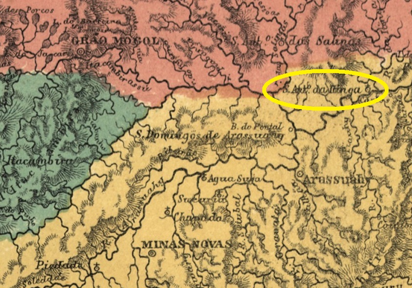
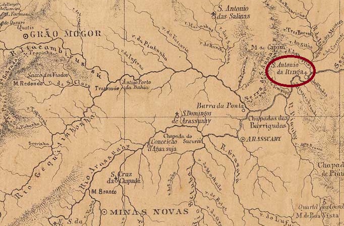
There was since 1805 the settlement of Sto. Antonio do Barreiro de Itinga on the north bank of the Jequitinhonha, 670 kilometres north of the later provincial capital Ouro Preto. In May 1850, it became the Distrito de Sto. Antonio do Itinga, which belonged to Vila de Minas Novas. This was followed in April 1854 by the elevation to a freguesia, this time under the Vila de Arassuahy. Itinga has been an independent município since December 1943. The word comes from the Tupi-guarani and means clear water.
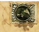
Paula Sobrinho (História Postal de Minas Gerais, Belo Horizonte, 1997) and R. Koester (Carimbologia XXIV) agree that there had been a post office there since January 1879. Initially, the stamps were cancelled by hand, as the illustration in Koester (op. cit.) shows.
1882ff (RK)
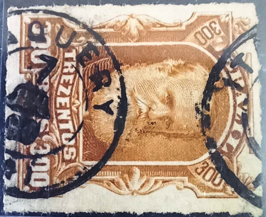
Later, the double circle IMG-1385a (illustration by Claudio Coelho) was added, which also exists in red-brown:
IMG-1385a (CC) 1885ff-1888Provincia de Minas Geraes, 1873
Seit 1805 existierte die Siedlung Sto. Antonio do Barreiro de Itinga am Nordufer des Jequitinhonha, 670 km nördlich der späteren Provinzhauptstadt Ouro Preto. Im Mai 1850 wurde der Distrito de Sto. Antonio do Itinga, der zu Vila de Minas Novas gehörte. Im April 1854 folgte die Erhebung zur Freguesia, diesmal von Vila de Arassuahy aus. Seit Dezember 1943 ist Itinga ein unabhängiges Município. Das Wort stammt aus dem Tupi-guarani und bedeutet klares Wasser.
Paula Sobrinho (História Postal de Minas Gerais, Belo Horizonte, 1997) und R. Koester (Carimbologia XXIV) sind sich einig, dass es dort seit Januar 1879 ein Postamt gab. Anfangs wurden die Briefmarken noch von Hand entwertet, wie die Abbildung bei Koester (a.a.O.) zeigt.
1882ff (RK)
Später kam der Doppelkreis IMG-1385a (Abb. Claudio Coelho) hinzu, der auch in rotbraun existiert:
Villiers de l’Ile Adam: Carta (…) da Provincia de Minas Geraes, 1849
Other names: Itaberaba
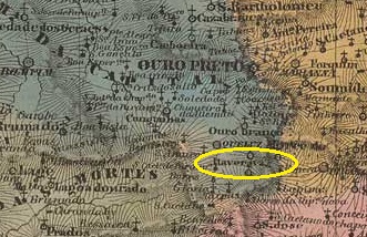
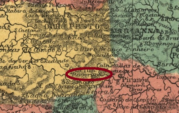
The Freguesia de Sto. Antonio do Itaverava was founded in January 1752, belonged to the Vila de Queluz and was located more than 50 kilometres south of the later provincial capital Ouro Preto. The village became a distrito in the Município de Conselheiro Lafaiete in March 1934 and has been the Município de Itaverava since December 1962. The name from tupi-guarani means shining stone.
Here, too, Paula Sobrinho (História Postal de Minas Gerais, Belo Horizonte, 1997) and R. Koester (Carimbologia XXIV) agree that there had been a local post office since August 1879. The imperial postmark is IMG-1380a (fig. Koester, op. cit.):
IMG-1380a (RK) 1885-1886Atlas do Imperio do Brasil, 1868
Andere Namen: Itaberaba
Die Freguesia de Sto. Antonio do Itaverava wurde im Januar 1752 gegründet, gehörte zur Vila de Queluz und lag mehr als 50 km südlich der späteren Provinzhauptstadt Ouro Preto. Der Ort wurde im März 1934 ein Distrito im Município de Conselheiro Lafaiete und ist seit Dezember 1962 das Município de Itaverava. Der Begriff aus dem Tupi-guarani bedeutet glänzender Stein.
Auch hier sind sich Paula Sobrinho (História Postal de Minas Gerais, Belo Horizonte, 1997) und R. Koester (Carimbologia XXIV) einig, dass es seit August 1879 ein Postamt in Itaverava gab. Der kaiserliche Poststempel ist IMG-1380a (Abb. Koester, op. cit.):
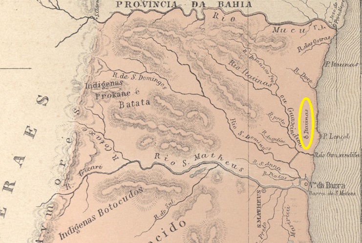
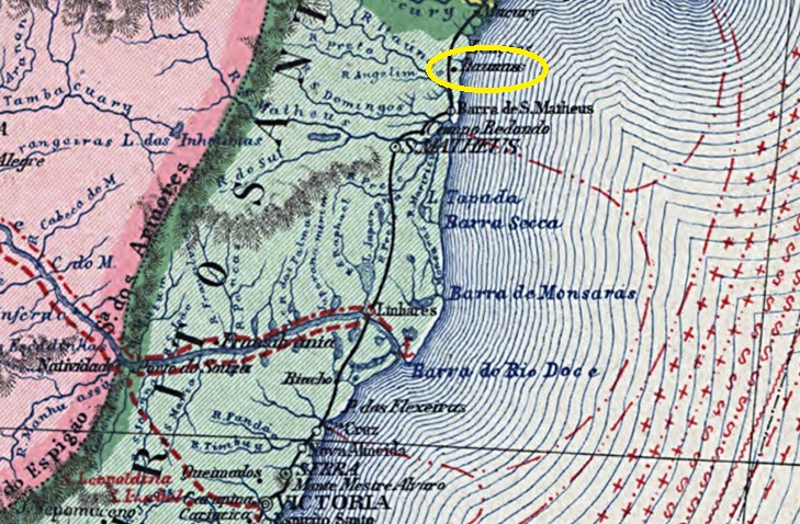
The Freguesia de S. Sebastião das Itaunas, founded in July 1861, belonged to the Vila de Barra de S. Matheus and was located on the west bank of the Itaúnas near its mouth into the Atlantic Ocean. Since September 1891, Itaúnas (current spelling) has been a district in the Município Conceição da Barra. The word comes from the Tupi-guarani and means yellow stones.
In March 1860, the decision was made to create a post office in the area, as reported in the Rio press:
Jornal do Commercio/RJ, 20/04/1860
According to P. Novaes (agenciaspostais.com.br), the postal agency was closed around 1869, and in October 1878 it was no longer listed among the post offices of Espírito Santo, although it was mentioned in the postal guide (Guia Postal do Imperio, Rio de Janeiro, 1880). No imperial postmarks from Itaunas are known to date.
Carta da Republica dos Estados Unidos do Brazil, 1892
Die im Juli 1861 gegründete Freguesia de S. Sebastião das Itaunas gehörte zur Vila de Barra de S. Matheus und lag am Westufer des Itaúnas nahe seiner Mündung in den Atlantik. Seit September 1891 ist Itaúnas (heutige Schreibweise) ein Distrito im Município Conceição da Barra. Das Wort stammt aus dem Tupi-guarani und bedeutet gelbe Steine.
Im März 1860 wurde der Beschluss gefasst, ein Postamt vor Ort einzurichten, wie die Presse in Rio berichtete:
Jornal do Commercio/RJ, 20.04.1860
Laut P. Novaes (agenciaspostais.com.br) wurde die Postagentur um 1869 geschlossen, und im Oktober 1878 war sie nicht mehr unter den Postämtern von Espírito Santo aufgeführt, obwohl sie im Postführer (Guia Postal do Imperio, Rio de Janeiro, 1880) erwähnt wurde. Bis heute sind keine kaiserlichen Poststempel von Itaunas bekannt.
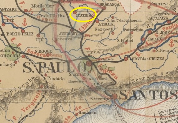
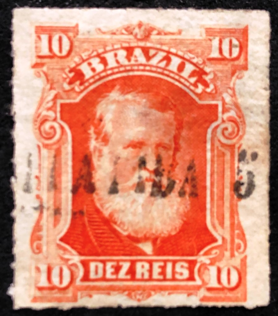
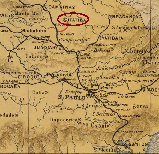
The Freguesia of N. Sra. de Belém was founded in December 1830 in the Município of Jundiaí and was located on the south bank of the river Atibaia, 80 km north of the provincial capital São Paulo. The place became a vila in February 1857 and a town in March 1876, renamed Itatiba a year later, probably to avoid confusion with places of the same name. The word from the Tupi-Guarany language means many stones.
As Nova Monteiro writes in Administrações e Agencias Postaes do Brasil Imperio (Brasil Filatelico/RJ, 1934-5; Reprint SPP 1994-1999), there had been a post office there since November 1859. The first postmark with the new place name is ISP-0140a (fig. Roberto Assef Jr.):
ISP-0140a (RA) 1877ff-1878ff
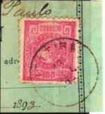
This was followed by the French type ISP-0140b, which was illustrated in P. Ayres’ Catálogo de Carimbos Brasil-Império (S. Paulo, 1937, 1942):
ISP-0140b (P.A. p. 117) 1879-1887
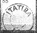
Then came the rare ISP-0140c (fig. R. Koester, in Carimbologia XXIV):
ISP-0140c (RK) 1888ff
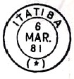
ISP-0140d (ill. Mário Celso Orsi Jr.) also appeared at the beginning of the Republic:
ISP-0140d (MO) 1893-1899
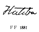
P. Ayres (op. cit.) also showed a handwritten cancellation from there:
1881ff (P.A. p. 147)
And José L. Fevereiro presented a mute cancellation from Itatiba:
1883 (JLF)
For postmarks with Bethlem de Jundiahy (until 1878) see BSP-0560).
J.M. Ribeiro Lisboa: Provincia de São Paulo,1884
Siehe auch Bethlem de Jundiahy (BSP-0560)
Die Freguesia von N. Sra. de Belém wurde im Dezember 1830 im Município von Jundiaí gegründet und lag am Südufer des Flusses Atibaia, 80 km nördlich der Provinzhauptstadt São Paulo entfernt. Der Ort wurde im Februar 1857 eine Vila und im März 1876 eine Stadt, die ein Jahr später zu Itatiba umbenannt wurde, wohl um Verwechslungen mit gleichnamigen Orten zu vermeiden. Das Wort aus der Tupi-Guarany-Sprache bedeutet viele Steine.
Wie Nova Monteiro in Administrações e Agencias Postaes do Brasil Imperio (Brasil Filatelico/RJ, 1934-5; Reprint SPP 1994-1999) schreibt, gab es dort ein Postamt seit November 1859. Der erste Poststempel mit dem neuen Ortsnamen ist ISP-0140a (Abb. Roberto Assef Jr.):
ISP-0140a (RA) 1877ff-1878ff
Es folgte der französischer typ ISP-0140b, der im P. Ayres’ Catálogo de Carimbos Brasil-Império (S. Paulo, 1937, 1942) abgebildet wurde:
ISP-0140b (P.A. S. 117) 1879-1887
Danach kam der seltene ISP-0140c (Abb. R.Koester, in Carimbologia XXIV):
ISP-0140c (RK) 1888ff
Am Anfang der Republik erschien auch ISP-0140d (Abb. Mário Celso Orsi Jr.):
ISP-0140d (MO) 1893-1899
P. Ayres (op. cit.) zeigte auch eine handschriftliche Entwertung von dort:
1881ff (P.A. S. 147)
Und José L. Fevereiro präsentierte einen stummen Stempel aus Itatiba:
1883 (JLF)
Für Poststempel mit Bethlem de Jundiahy (bis 1878) siehe BSP-0560.
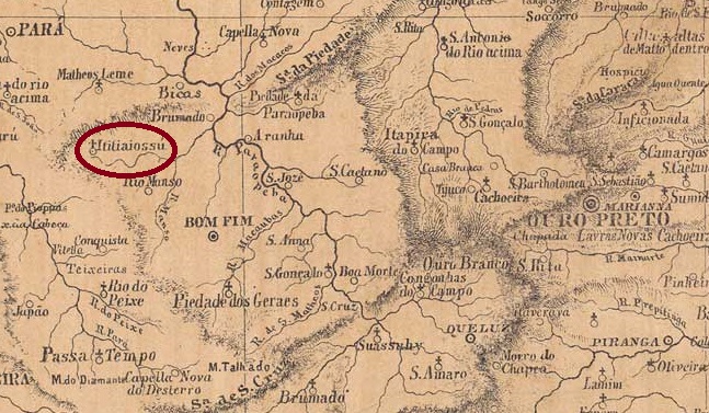
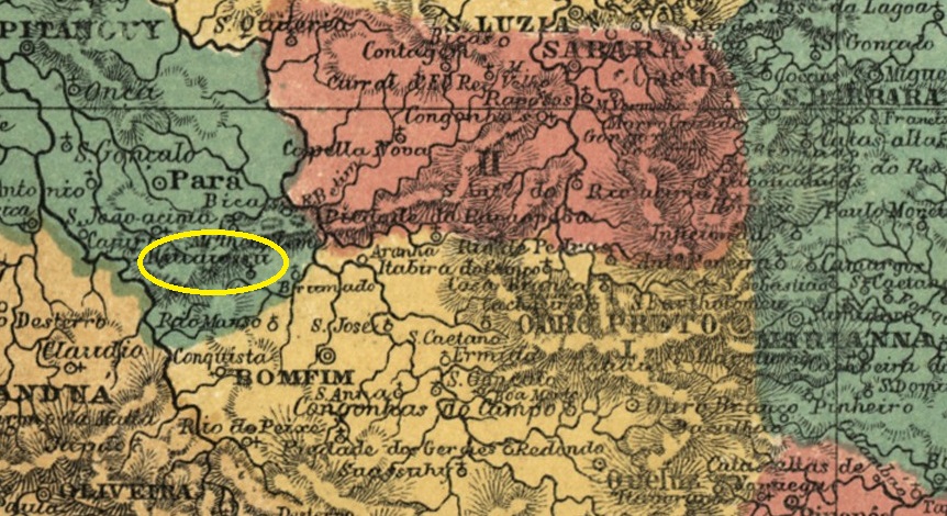
There had been a curato here since July 1832, which belonged to Vila de Bonfim, 160 kilometres west of the provincial capital Ouro Preto. In June 1850, it became the Freguesia de S. Sebastião do Itatiaiussú, which became a Distrito of the Município de Itaúna in September 1901. The spelling Itatiaiuçu has been in use since December 1948 and the village has been an independent município since December 1962.
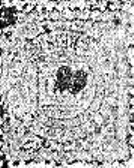
Paula Sobrinho (História Postal de Minas Gerais, Belo Horizonte, 1997) and R. Koester (Carimbologia XXIV) agree that there had been a post office there since May 1889. The imperial postmark is IMG-1375a (fig. Koester, op. cit.):
IMG-1375a (RK) 1889Atlas do Imperio do Brasil, 1868
Andere Namen: Itatiaiuçu (1948)
Seit Juli 1832 bestand hier ein Curato, das zu Vila de Bonfim gehörte, 160 km westlich der Provinzhauptstadt Ouro Preto. Im Juni 1850 wurde daraus die Freguesia de S. Sebastião do Itatiaiussú, die im September 1901 als Distrito zum Município de Itaúna kam. Seit Dezember 1948 ist die Schreibweise Itatiaiuçu gebräuchlich und seit Dezember 1962 ist der Ort ein eigenständiges Município.
Paula Sobrinho (História Postal de Minas Gerais, Belo Horizonte, 1997) und R. Koester (Carimbologia XXIV) sind sich einig, dass es dort seit Mai 1889 ein Postamt gab. Der kaiserliche Poststempel ist IMG-1375a (Abb. Koester, op.cit.):
Estações (…) do Rio de Janeiro, São Paulo e Minas Geraes, 1880
Other names: Est. Nhangapi (1943)
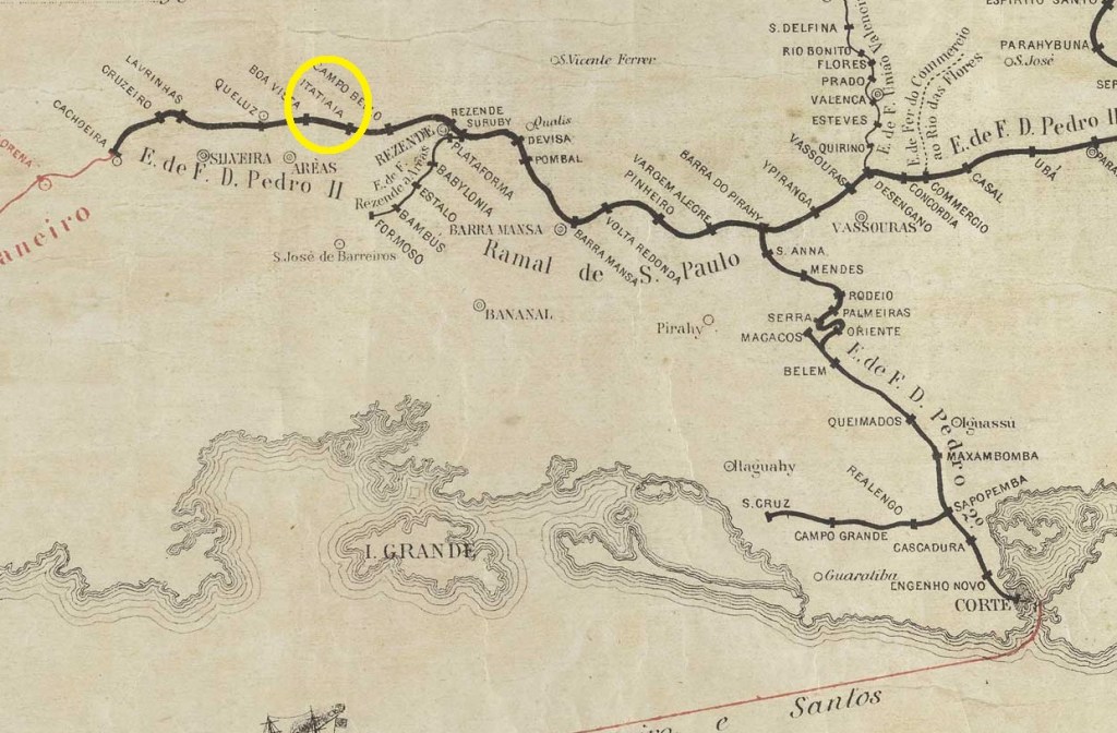
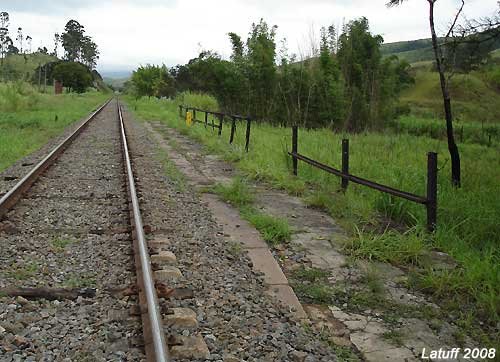
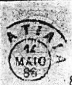
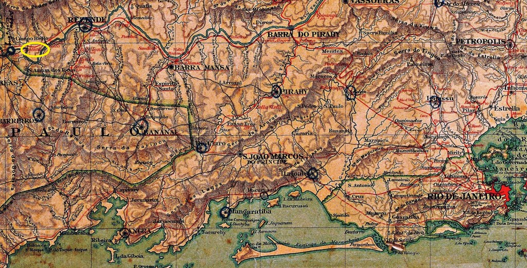
Itaiaia station (also spelt Itatyaia or Itatiaya) was opened in January 1874 by the E.F. D. Pedro II railway company (S. Paulo line) in the Município de Resende, 200 km north-west of the capital Rio de Janeiro. The word from the Tupi-guarani means rock with spikes. The line was transferred to E.F. Central do Brasil in 1889 and belonged to Rede Ferroviária Federal S.A. from 1975 until its closure in 1996 (estacoesferroviarias.com.br). The tracks are still there today, but the station building is no longer there.
In February 2008 (photo Carlos Latuff, on estacoesferroviarias.com.br)
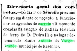
The area around the railway station has belonged to the Distrito de Itatiaia since December 1943, when the station was renamed Nhangapi (Devil’s Path, in tupi-guarani); Itatiaia has been an independent município since July 1988.
There had been a post office at the railway station since January 1874, as reported in the Rio press:
A Reforma, 28/01/1874
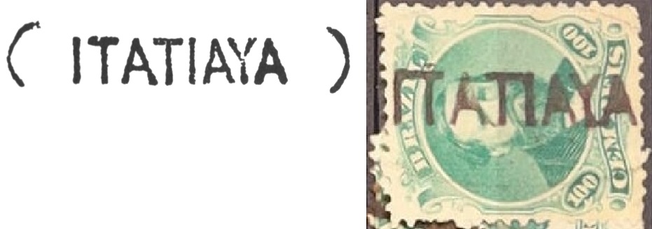
The first postmark is IRJ-1785a, which was given the no. 1145 in P. Ayres’ Catálogo de Carimbos Brasil-Império (S. Paulo, 1937, 1942), here also on an example from the Marcio Duarte collection:
IRJ-1785a (P.A. 1145, MPT 350 – MD) 1874ff
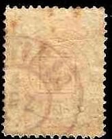
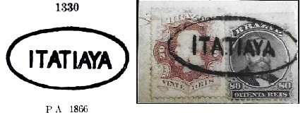
This was followed by IRJ-1785b, which also exists in blue and was given the no. 1330 by P. Ayres, here with a corrected version from agenciaspostais.com.br:
IRJ-1785b (P.A. 1330 – recte PN) 1874ff-1876ff
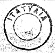
Then came the rare IRJ-1785c (fig. R. Koester, in Carimbologia XXIV):
IRJ-1785c (RK) 1880-1882
Shortly afterwards, IRJ-1785d (fig. Koester) was also used, which also occurs in blue:
IRJ-1785d (RK) 1885-1886
Towards the end of the Empire, IRJ-1785e also appeared (fig. agenciaspostais.com.br):
IRJ-1785e (PN) 1887-1897
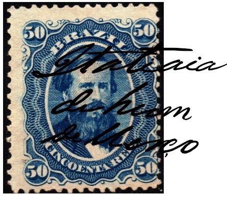
The philatelist Carlos A. Balata also showed a hand-written cancellation from Itatiaia:
1874ff-1877ff (CB)Almanak Laemmert, 1892
Andere Namen: Est. Nhangapi (1943)
Der Bahnhof Itaiaia (auch Itatyaia oder Itatiaya geschrieben) wurde im Januar 1874 von der Eisenbahngesellschaft E.F. D. Pedro II (S. Paulo-Linie) eröffnet und lag im Município de Resende, 200 km nordwestlich der Hauptstadt Rio de Janeiro. Das Wort aus dem Tupi-guarani bedeutet Felsen mit Spitzen. Die Strecke ging 1889 an die E.F. Central do Brasil über und gehörte von 1975 bis zu ihrer Stilllegung 1996 der Rede Ferroviária Federal S.A. (estacoesferroviarias.com.br). Heute sind die Gleise noch vorhanden, das Bahnhofsgebäude jedoch nicht mehr.
Im Februar 2008 (Foto Carlos Latuff, auf estacoesferroviarias.com.br)
Das Gebiet um den Bahnhof gehört seit Dezember 1943 zum Distrito de Itatiaia, als der Bahnhof in Nhangapi (Teufelsweg, in tupi-guarani) umbenannt wurde, seit Juli 1988 ist Itatiaia ein eigenständiges Município.
Seit Januar 1874 gibt es ein Postamt am Bahnhof, wie die Presse von Rio berichtet:
A Reforma, 28.01.1874
Der erste Poststempel ist IRJ-1785a, der in P. Ayres‘ Catálogo de Carimbos Brasil-Império (S. Paulo, 1937, 1942) die Nr. 1145 erhielt, hier auch auf einem Beispiel aus der Sammlung Marcio Duarte:
IRJ-1785a (P.A. 1145, MPT 350 – MD) 1874ff
Es folgte IRJ-1785b, der auch in Blau existiert und von P. Ayres die Nr. 1330 erhielt, hier mit einer korrigierten Version aus agenciaspostais.com.br:
IRJ-1785b (P.A. 1330 – recte PN) 1874ff-1876ff
Danach kam der seltene IRJ-1785c (Abb. R. Koester, in Carimbologia XXIV):
IRJ-1785c (RK) 1880-1882
Kurz darauf wurde auch IRJ-1785d (Abb. Koester) verwendet, der auch in Blau vorkommt:
IRJ-1785d (RK) 1885-1886
Gegen Ende des Kaiserreichs erschien auch IRJ-1785e (Abb. agenciaspostais.com.br):
IRJ-1785e (PN) 1887-1897
Der Philatelist Carlos A. Balata zeigte auch eine handschriftliche Entwertung aus Itatiaia:
Carta da Republica dos Estados Unidos do Brazil, 1892
Other names: Barreira do Itararé
The history of the village begins in 1847 with the founding of the Fazenda de S. Pedro de Itararé on the north bank of the Itararé, close to the border with the province of Paraná, 340 kilometres west of the capital São Paulo. In March 1855 it became a Curato and 30 years later the Freguesia da Capella de N. Sra. da Conceição do Itararé, which belonged to the Vila de Itapeva da Faxina. In August 1893 it was elevated to Vila de S. Pedro de Itararé, in September 1901 it became a town and since December 1922 it has officially been called Itararé. The word comes from the Tupi-guarani language and means stone hollowed out by the river.
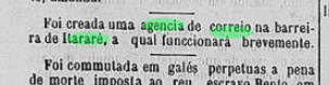
According to the regional press, there has been a post office since January 1880:
Jornal da Tarde, 14.01.1880
The imperial postmark is the French type ISP-0945a (fig. R. Koester, in Carimbologia XXIV):
ISP-0945a (RK) 1882-1899Carlos D. Rath: Provincia de São Paulo, 1886
Andere Namen: Barreira do Itararé
Die Geschichte des Ortes beginnt 1847 mit der Gründung der Fazenda de S. Pedro de Itararé am Nordufer des Itararé, nahe der Grenze zur Provinz Paraná, 340 km westlich der Hauptstadt São Paulo. Im März 1855 wurde sie Curato und 30 Jahre später Freguesia da Capella de N. Sra. da Conceição do Itararé, die zur Vila de Itapeva da Faxina gehörte. Im August 1893 erfolgte die Erhebung zur Vila de S. Pedro de Itararé, im September 1901 wurde sie zur Stadt und seit Dezember 1922 heißt sie einfach Itararé. Das Wort stammt aus der Sprache der Tupi-guarani und bedeutet vom Fluss ausgehöhlter Stein.
Wie aus der regionalen Presse hervorgeht, gab es seit Januar 1880 ein Postamt:
Jornal da Tarde, 14.01.1880
Der kaiserliche Poststempel istder französische Typ ISP-0945a (Abb. R. Koester, in Carimbologia XXIV):
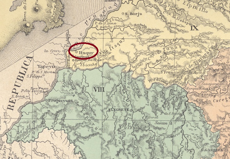
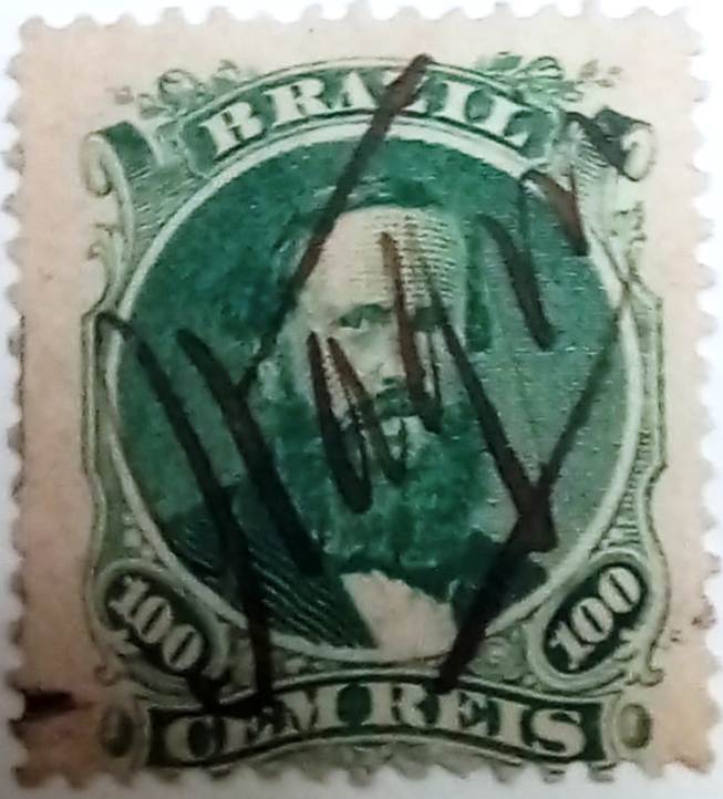
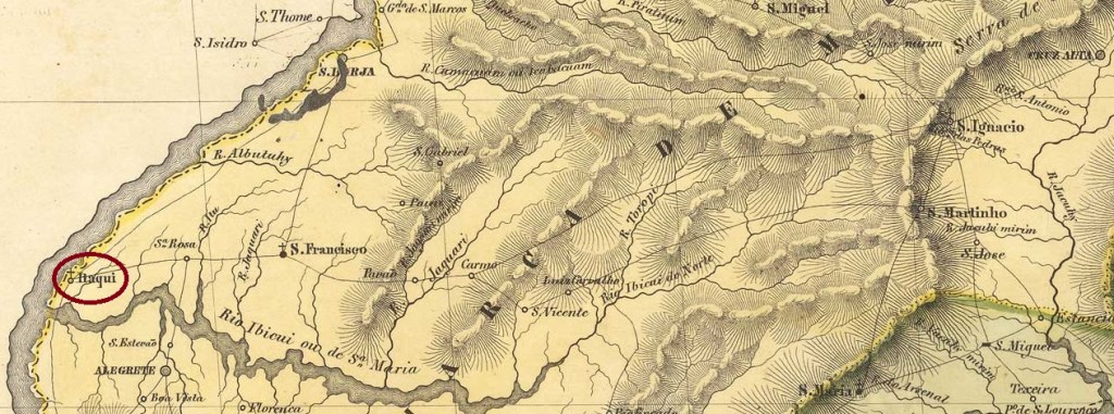
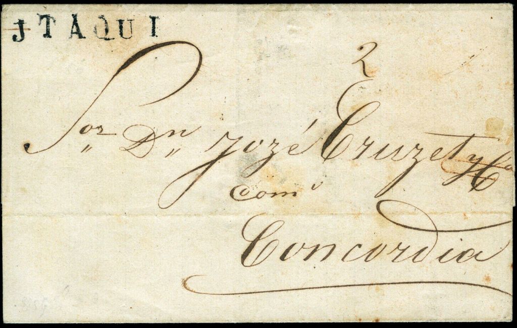
The Freguesia de S. Patricio de Itaqui, in existence since December 1837, belonged to the Vila de S. Borja and was located on the south bank of the Uruguai, 670 kilometres west of the provincial capital Porto Alegre. In December 1858 it became a Vila and in May 1879 a town. The name comes from the Tupi-guarani language and means grinding stone.
Nova Monteiro writes in Administrações e Agencias Postaes do Brasil Imperio (Brasil Filatelico/RJ, 1934-5; reprint SPP 1994-1999) that there had been a post office there since January 1858. This is confirmed by the report of the General Directorate of the Post Office from that year:
Relatorio da Directoria Geral dos Correios, 1858
The oldest postmark was found on a letter to Argentina. As it dates from September 1856 (image from the Internet) and therefore predates the opening of the postal agency, it could be a forgery:
Letter dated 30/09/1856 (HS)
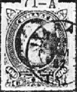
In contrast, IRS-0195a (illustration by Felipe Piccinini) from 1859 is proven to be genuine:
IRS-0195a (FP) 1859
This was followed by a handwritten cancellation (Fuad Ferreira Fo. collection):
1866ff (FF)
The following IRS-0195b also appears in blue and received the no. 1329 in P. Ayres’ Catálogo de Carimbos Brasil-Império (S. Paulo, 1937, 1942):
IRS-0195b (P.A. 1329) 1866ff-1876ff
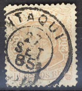
Towards the end of the Empire, the double circle IRS-0195c (collect. FM) also appeared. The inner years have different formats, the cancel also exists in dark violet.
IRS-0195c (FM) 1877-1890Villiers de l’Ile Adam: Carta (…) da Provincia de São Pedro, 1847
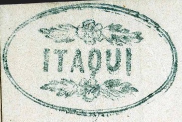
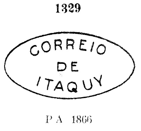
Andere Schreibweise: Itaquy
Die seit Dezember 1837 bestehende Freguesia de S. Patricio de Itaqui gehörte zur Vila de S. Borja und lag am Südufer des Uruguai, 670 km westlich der Provinzhauptstadt Porto Alegre. Im Dezember 1858 wurde es zur Vila und im Mai 1879 zur Stadt erhoben. Der Name stammt aus der Sprache der Tupi-guarani und bedeutet Schleifstein.
Nova Monteiro schreibt in Administrações e Agencias Postaes do Brasil Imperio (Brasil Filatelico/RJ, 1934-5; Reprint SPP 1994-1999), dass es dort seit Januar 1858 ein Postamt gab. Dies wird durch den Bericht der Generaldirektion der Post aus dem Jahr bestätigt:
Relatorio da Directoria Geral dos Correios, 1858
Der älteste Poststempel wurde auf einem Brief nach Argentinien gefunden. Da er vom September 1856 (Abbildung aus dem Internet) und damit vor der Eröffnung der Postagentur stammt, könnte es sich um eine Fälschung handeln:
Brief v. 30.09.1856 (HS)
Sicher als echt belegt ist dagegen IRS-0195a (Abb. Felipe Piccinini) aus dem Jahr 1859:
IRS-0195a (FP) 1859
Es folgte eine handschriftliche Entwertung (Samml. Fuad Ferreira Fo.):
1866ff (FF)
Die folgende IRS-0195b erscheint auch in blau und erhielt die Nr. 1329 in P. Ayres‘ Catálogo de Carimbos Brasil-Império (S. Paulo, 1937, 1942)
IRS-0195b (P.A. 1329) 1866ff-1876ff
Gegen Ende des Kaiserreichs erschien auch der Doppelkreis IRS-0195c (Samml. FM). Die inneren Jahreszahlen haben unterschiedliche Formate, den Stempel gibt es auch in dunkelviolett.
Other names: Itaquery da Várzea, Itaquery de Baixo, Itaqueri Velho
See also Itaquery de Cima da Serra (ISP-0640)
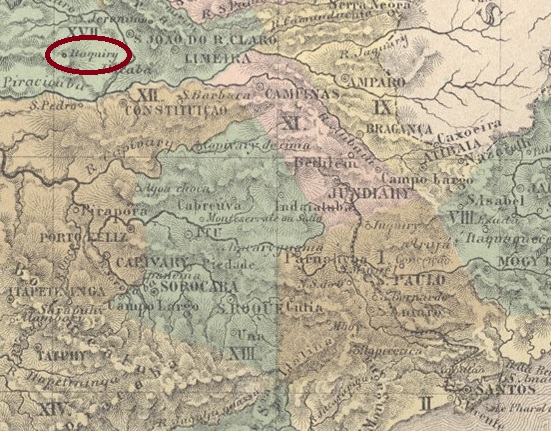
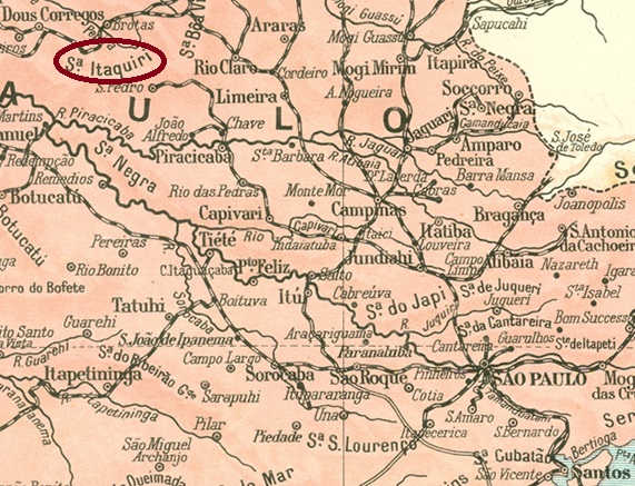
It is not known when and how this village was founded. It was located on the Itaquery River (today probably Jacaré-Guaçu), 220 km north-west of the provincial capital of São Paulo, and became the seat of the Freguesia de Itaquery in the Vila de Rio Claro area in March 1873.
With the construction of the Rio Claro railway line and the establishment of the Morro Pelado station, the Itaquery population began to migrate and the old settlement began to decline from 1885. Today, Itaqueri Velho is a rural suburb of the Município de Itirapina, which was founded in March 1935. In the Tupi-guarani language, Itaquery means river of lying stones and Itirapina means bare mountain (port.: Morro Pelado).
The local post office was probably relocated with the old settlement of Itaquery de Cima in 1873. The imperial postmark is the rare French type ISP-0635a (collect. Fuad Ferreira Fo.):
ISP-0635a (FF) 1880Carta da Republica dos Estados Unidos do Brazil, 1892
Andere Namen: Itaquery da Várzea, Itaquery de Baixo, Itaqueri Velho
Siehe auch Itaquery de Cima da Serra (ISP-0640)
Wann und wie dieser Ort entstanden ist, ist nicht bekannt. Er lag am Fluss Itaquery (heute wahrscheinlich Jacaré-Guaçu), 220 km nordwestlich der Provinzhauptstadt São Paulo, und wurde im März 1873 Sitz der Freguesia de Itaquery im Gebiet der Vila de Rio Claro.
Mit dem Bau der Eisenbahnlinie Rio Claro und der Einrichtung des Bahnhofs Morro Pelado begann ab 1885 die Abwanderung der Bevölkerung und der Verfall der alten Siedlung. Heute ist Itaqueri Velho ein ländlicher Vorort des Município de Itirapina, das im März 1935 gegründet wurde. In der Sprache der Tupi-guarani bedeutet Itaquery Fluss der liegenden Steine und Itirapina kahler Berg (port.: Morro Pelado).
Das örtliche Postamt wurde wahrscheinlich 1873 mit der alten Siedlung Itaquery de Cima verlegt. Der kaiserliche Poststempel ist der seltene französische Typ ISP-0635a (Samml. Fuad Ferreira Fo.):
Other names: Itaquiry, Itaquery de Cima, Itaquery da Serra (1903)
The history of this village is inextricably linked to the neighbouring villages of Itaquery (de Baixo, ISP-0635) and Morro Pelado (MSP-0835, today Itirapina). In May 1839, the chapel of N. Sra. da Conceição da Serra do Itaquery was built on the territory of Vila de Rio Claro, 240 kilometres northwest of the provincial capital of São Paulo, which was elevated to the status of a freguesia in July 1852. As the location in the low mountain range soon proved unfavourable, the community moved to the lower-lying Itaquery de Baixo (also known as Itaquery da Várzea) around 1873 and allowed the old settlement to fall into disrepair.
The situation changed again with the construction of the Rio Clarense railway line: the Morro Pellado (Bald Mountain) station, built nearby in 1885, attracted the population of Itaquery and also initiated the decline of the young settlement.
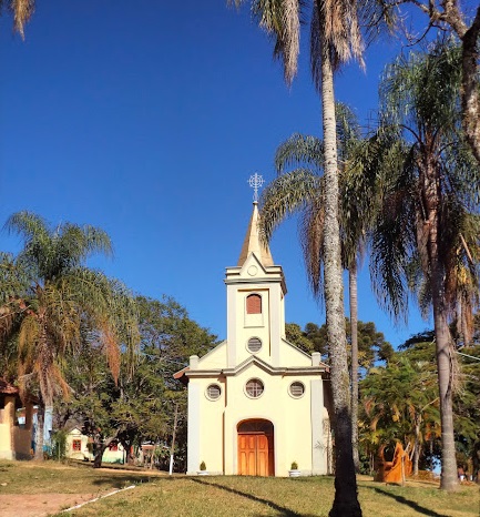
It was not until October 1903 that the old Itaquery de Cima became the Distrito de Itaquery da Serra, which was assigned to the newly founded Município de Itirapina in March 1935. Today, Itaqueri da Serra (as it is now spelt) is a popular tourist destination with the rebuilt chapel of N. Sra. da Conceição.
Photo: Renato Barbosa Melo, on Google Maps
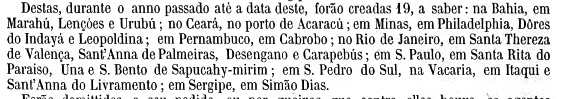
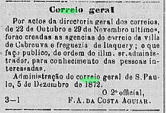
The turmoil of the settlement’s history is reflected in the postal system. In November 1872, a local post office was created, as reported in the regional press:
Diario de S. Paulo, 06/12/1872
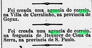
Presumably from 1873, the agency was also moved to Itaquery de Baixo. It was not until August 1888 that a post office was reopened in Itaquery de Cima, as reported in the Rio press:
Diario de Noticias/RJ, 29/08/1888
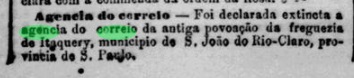
However, as this was already closed again the following October, as reported by the press in Rio, it is questionable whether the agency carried out the second period of operation at all:
Jornal do Commercio/RJ, 04/10/1888
To date, no imperial postmarks from Itaquery de Cima have surfaced, which is not surprising given the narrow time window of its postal operations.
Monteiro & Oliveira: Estado de São Paulo, 1927
Andere Namen: Itaquiry, Itaquery de Cima, Itaquery da Serra (1903)
Die Geschichte dieses Ortes ist untrennbar mit den Nachbarorten Itaquery (de Baixo, ISP-0635) und Morro Pelado (MSP-0835, heute Itirapina) verbunden. Im Mai 1839 wurde die Kapelle N. Sra. da Conceição da Serra do Itaquery auf dem Gebiet der 240 km nordwestlich der Provinzhauptstadt São Paulo gelegenen Vila de Rio Claro errichtet, die im Juli 1852 zur Freguesia erhoben wurde. Da sich die Lage am Mittelgebirge bald als ungünstig erwies, zog die Gemeinde um 1873 in das tiefer gelegene Itaquery de Baixo (auch Itaquery da Várzea genannt) und ließ die alte Siedlung verfallen.
Mit dem Bau der Eisenbahnlinie Rio Clarense änderte sich die Situation erneut: Der 1885 in der Nähe errichtete Bahnhof Morro Pellado (Kahler Berg) zog die junge Siedlung Itaquery an und leitete auch deren Niedergang ein.
Erst im Oktober 1903 wurde aus dem alten Itaquery de Cima der Distrito de Itaquery da Serra, der im März 1935 als Distrito dem damals neu gegründeten Município de Itirapina zugeordnet wurde. Heute ist Itaqueri da Serra (wie es heute geschrieben wird) ein beliebtes Touristenziel mit der wieder aufgebauten Kapelle N. Sra. da Conceição.
Foto: Renato Barbosa Mello, auf Google Maps
Die Wirren der Siedlungsgeschichte spiegeln sich im Postwesen wider. Im November 1872 wurde beschlossen, ein örtliches Postamt einzurichten, wie die regionale Presse berichtete:
Diario de S. Paulo, 06.12.1872
Vermutlich ab 1873 wurde auch die Agentur nach Itaquery de Baixo verlegt. Erst im August 1888 sollte wieder ein Postamt in Itaquery de Cima eröffnet werden, wie aus der Presse in Rio hervorgeht:
Diario de Noticias/RJ 29.08.1888
Da dieses jedoch bereits im darauffolgenden Oktober wieder geschlossen wurde, wie die Presse in Rio berichtete, ist fraglich, ob die Agentur die zweite Betriebsperiode überhaupt durchführte:
Jornal do Commercio/RJ, 04.10.1888
Bisher sind keine kaiserlichen Poststempel aus Itaquery de Cima aufgetaucht, was angesichts des engen Zeitfensters ihres Postbetriebs nicht verwunderlich ist.