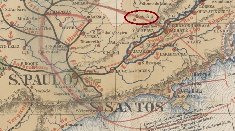
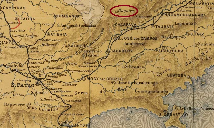
The freguesia of N. Sa. da Piedade do Buquira was founded in April 1857 in the Município of Taubaté on the left bank of the Buquira, 130 km northeast of the provincial capital of São Paulo. It then changed jurisdiction twice: to Caçapava in April 1866 and to S. José dos Campos in July 1867. In April 1880 it became a vila. After a good four years as a district of S. José dos Campos (May 1844 to December 1948), its status as a vila returned, now as the município of Monteiro Lobato. The name commemorates José Bento Monteiro Lobato (1882-1948), a writer whose family owned a fazenda there.
MiNr. 885/Scott 829/RHM C-370
According to the Directory of Imperial Post Offices (Tabella das Agencias do Correio do Imperio, Rio de Janeiro, 1885), there had been a post office there since 1879. The only imperial postmark so far is the French type BSP-0195a, with dates between 1881 and 1903, already shown by R. Koester in Carimbologia VI:
BSP-0195a (RK) 1881-1903J. M. Ribeiro Lisboa: Provincia de São Paulo, 1884
Anderer Name: Monteiro Lobato (1948)
Die Freguesia von N. Sa. da Piedade do Buquira wurde im April 1857 gegründet und lag im Município von Taubaté am linken Ufer des Buquira, 130 km nordöstlich der Provinzhauptstadt São Paulo. Danach wechselte sie zweimal die Zuständigkeit: im April 1866 nach Caçapava und im Juli 1867 nach S. José dos Campos. Im April 1880 wurde es zur Vila. Nach gut vier Jahren als Distrikt von S. José dos Campos (Mai 1844 bis Dezember 1948) kehrte der Status als Vila zurück, nun als Município von Monteiro Lobato. Der Name erinnert an José Bento Monteiro Lobato (1882-1948), einen Schriftsteller, dessen Familie dort eine Fazenda besaß.
MiNr. 885/Scott 829/RHM C-370
Nach dem Verzeichnis der kaiserlichen Postämter (Tabella das Agencias do Correio do Imperio, Rio de Janeiro, 1885) gab es dort seit 1879 ein Postamt. Der einzige kaiserliche Poststempel ist bisher der französische Typ BSP-0195a, mit Daten zwischen 1881 und 1903, der bereits von R. Koester in Carimbologia VI gezeigt wurde:
Other names: Boquinha da Mata, Lagoa Vermelha, Boquim (1938, 1976)
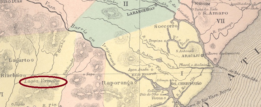
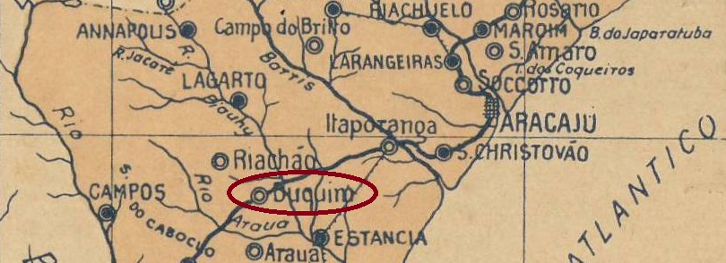
The history of this place is somewhat confusing, as it has changed not only its name but also its location. It was originally called Lagoa Vermelha (Red Lake), a parish on the Piauí River (also called Jacaré) founded in April 1855 and elevated to a vila in February 1857. However, the situation was very unfavourable: in addition to malaria epidemics, there were frequent floods. Therefore, in March 1870, the entire community was moved to neighbouring Boquinha da Mata, 80 km west of the provincial capital Aracaju. It was given the name Sant’Anna do Buquim and became a town in December 1926, spelled Boquim since January 1976.
There had been a post office in Lagoa Vermelha since 1862, as shown in the Directory of Imperial Post Offices (Tabella das Agencias do Correio do Imperio, Rio de Janeiro, 1885). The Buquim post office existed from 1879, as shown in the Imperial Postal Guide (Guia Postal do Imperio) for 1880. No imperial postmarks from Buquim are known so far.
Arthur D. Ribeiro: Estado de Sergipe, 1924
Andere Namen: Boquinha da Mata, Lagoa Vermelha, Boquim (1938, 1976)
Die Geschichte dieses Ortes ist etwas verwirrend, da er nicht nur seinen Namen, sondern auch seinen Sitz wechselte. Ursprünglich hieß er Lagoa Vermelha (Roter See), eine im April 1855 gegründete Pfarrei am Fluss Piauí (auch Jacaré genannt), die im Februar 1857 zur Vila erhoben wurde. Die Lage war jedoch sehr ungünstig: zu den Malariaepidemien kamen häufig Überschwemmungen hinzu. Daher wurde die gesamte Gemeinde im März 1870 in das benachbarte Boquinha da Mata, 80 km westlich der Provinzhauptstadt Aracaju, verlegt. Es erhielt den Namen Sant’Anna do Buquim und wurde im Dezember 1926 eine Stadt, die seit Januar 1976 Boquim geschrieben wird.
In Lagoa Vermelha gab es seit 1862 ein Postamt, wie aus dem Verzeichnis der kaiserlichen Postämter (Tabella das Agencias do Correio do Imperio, Rio de Janeiro, 1885) hervorgeht. Das Postamt Buquim existierte ab 1879, wie aus dem kaiserlichen Postführer (Guia Postal do Imperio) für 1880 hervorgeht. Bisher sind keine kaiserlichen Poststempel aus Buquim bekannt.
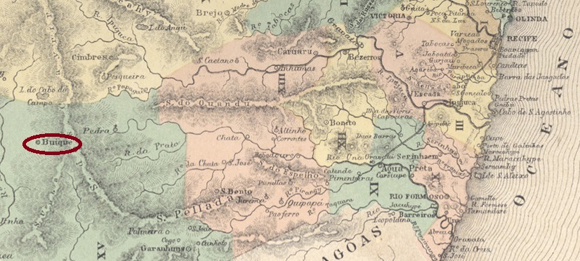
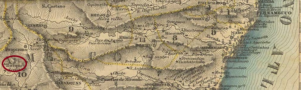
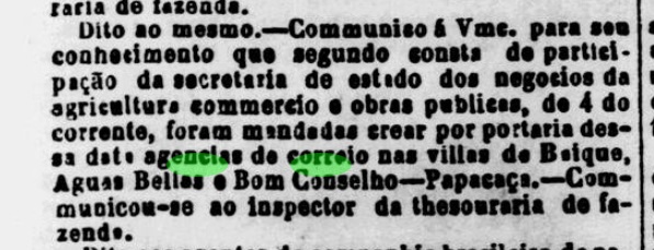
The Freguesia de Villa Nova de Buique was founded in December 1795 and at that time belonged to the Vila de Garanhuns, located 280 km west of the provincial capital Recife. The place was elevated to villa status in May 1854 and to town status ten years later.
There had been a post office there since October 1862, as the regional press reported:
Diário de Pernambuco/18.10.1862
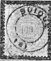
The only postmark so far is BPE-0140b, already presented by R. Koester (Carimbologia VI), with internal dates from 1886 to at least 1888:
BPE-0140b (RK) 1886-1888ffVilliers de l’Ile Adam: Carta (…) das Provincias de Pernambuco, Alagoas e Sergipe, 1848
Die Freguesia namens Villa Nova de Buique wurde im Dezember 1795 gegründet und gehörte damals zur Vila de Garanhuns, 280 km westlich der Provinzhauptstadt Recife gelegen. Der Ort wurde im Mai 1854 zur Villa und zehn Jahre später zur Stadt erhoben.
Seit Oktober 1862 gab es dort ein Postamt, wie die regionale Presse berichtete:
Diário de Pernambuco/18.10.1862
Der bisher einzige Poststempel ist BPE-0140b, der bereits von R. Koester (Carimbologia VI) vorgestellt wurde und interne Daten von 1886 bis mindestens 1888 aufweist:
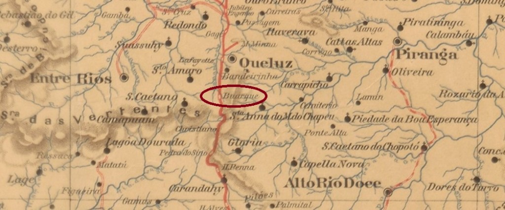
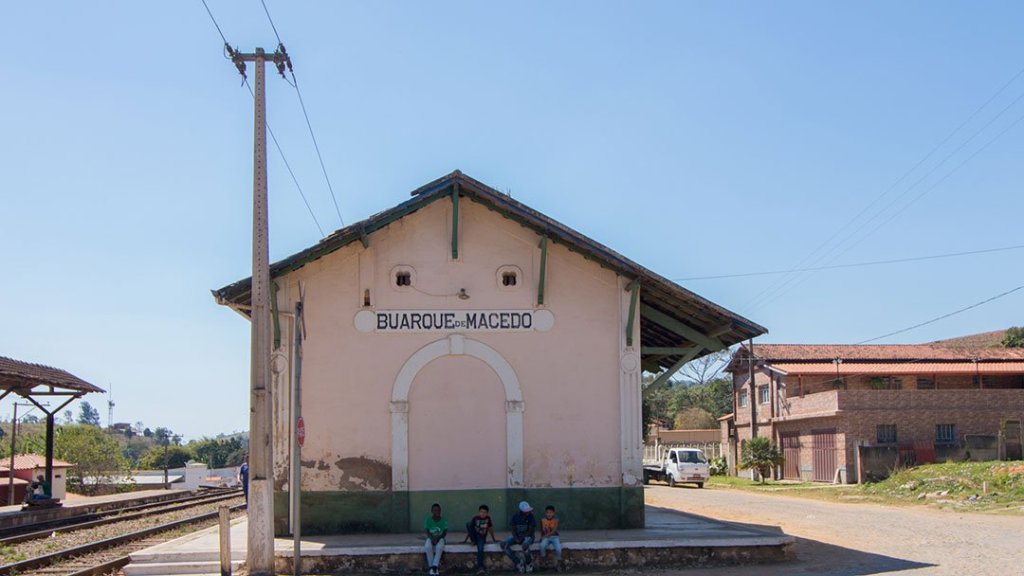
Buarque de Macedo station was opened in December 1883 by the E.F. D. Pedro II (Main Line) and was located in the Município of Queluz, 70 km southwest of the provincial capital Ouro Preto. The line passed to the E.F. Central do Brasil in 1889 and belonged to Rede Ferroviária Federal S.A. (estacoesferroviarias.com.br) from 1975 until its closure in 1996. Today, the tracks are still there, but the station building has fallen into disrepair.
2016 (Photo: Alex de Lima on estacoesferroviarias.com.br)
The name of the station commemorates Manoel Buarque de Macedo (1837-1881), a politician from Pernambuco who was Minister of Transport (Ministro das Obras Públicas) during the Empire and died suddenly while travelling with D. Pedro II.
As Paula Sobrinho writes in História Postal de Minas Gerais (Belo Horizonte, 1997), there was a post office in the station since June 1884 with the cancel BMG-0415a, already made known by R. Koester (Carimbologia VI):
BMG-0415a (RK)Google Maps
Der Bahnhof Buarque de Macedo wurde im Dezember 1883 von der E.F. D. Pedro II (Hauptstrecke) eröffnet und lag im Município von Queluz, 70 km südwestlich der Provinzhauptstadt Ouro Preto. Die Strecke ging 1889 an die E.F. Central do Brasil über und gehörte von 1975 bis zu ihrer Stilllegung 1996 der Rede Ferroviária Federal S.A. (estacoesferroviarias.com.br). Heute sind die Gleise noch vorhanden, das Bahnhofsgebäude ist dem Verfall preisgegeben.
2016 (Foto: Alex de Lima auf estacoesferroviarias.com.br)
Der Name des Bahnhofs erinnert an Manoel Buarque de Macedo (1837-1881), einen Politiker aus Pernambuco, der im Kaiserreich Verkehrsminister (Ministro das Obras Públicas) war und während einer gemeinsamen Reise mit D. Pedro II. plötzlich verstarb.
Wie Paula Sobrinho in História Postal de Minas Gerais (Belo Horizonte, 1997) schreibt, gab es im Bahnhof seit Juni 1884 ein Postamt mit dem Stempel BMG-0415a, der bereits von R. Koester (Carimbologia VI) bekannt gemacht wurde:
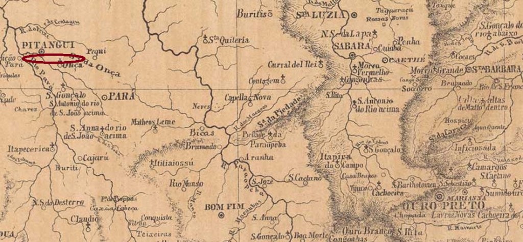
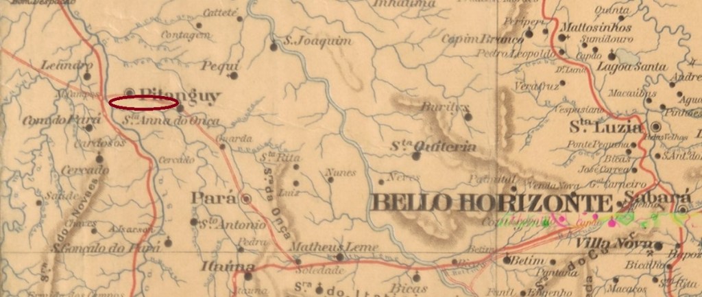
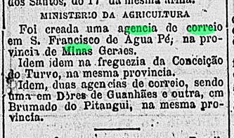
This small village with a small church in honour of S. Gonçalo was located south of the villa of Pitangui, 210 km northwest of the provincial capital Ouro Preto. It apparently never was a freguesia and only became a district in April 1926, but this status was also lost at some point, as today Brumado is merely a rural suburb in the Município of Pitangui.
The local post office was started in February 1881, as one can read in the Rio press:
Gazeta de Noticias/RJ, 21/02/1881
According to the postal guide (Guia Postal do Imperio) of 1880, hardly more than 700 people lived there at that time, many of them working in a fabric factory. The owner of this factory must have had good contacts with the provincial politicians, otherwise it would be difficult to explain the establishment of a postal agency. No imperial postmark from Brumado do Pitangui has yet been found.
Estado de Minas Geraes, 1910
Diese kleine Ortschaft mit einer kleinen Kirche zu Ehren von S. Gonçalo lag südlich der Villa von Pitangui, 210 km nordwestlich der Provinzhauptstadt Ouro Preto entfernt. Sie wurde offenbar nie zu einer Freguesia und erst im April 1926 zu einem Distrikt, aber dieser Status ging auch irgendwann verloren, denn heute ist Brumado lediglich ein ländlicher Vorort im Município von Pitangui.
Das örtliche Postamt wurde im Februar 1881 in Leben gerufen, wie man aus der Rio-Presse erfahren kann:
Gazeta de Noticias/RJ, 21.02.1881
Laut Postführer (Guia Postal do Imperio) von 1880 lebten dort damals kaum mehr als 700 Menschen, davon viele, die in einer Stofffabrik arbeiteten. Deren Besitzer muss also gute Kontakte zu den Provinzpolitikern gehabt haben, sonst wäre die Gründung einer Postagentur schwer zu erklären. Kein kaiserlicher Poststempel von Brumado do Pitangui wurde bisher gefunden.
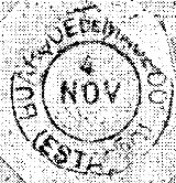
Other names: Entre Rios, João Ribeiro, Entre Rios de Minas (1953)
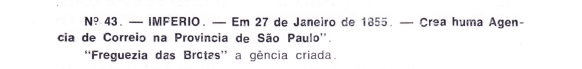
The parish of N. Sra. das Grotas de Brumado was founded in July 1832, belonged to the Vila of Queluz and was located between the rivers Brumado and Camapuã, 90 km southwest of the provincial capital Ouro Preto. In January 1875, it became the Vila of Brumado do Suassuhy, which was renamed Entre Rios in October 1878. In January 1880, it became a town, and has since had two new names: in December 1938, it was called João Ribeiro, and 15 years later, Entre Rios de Minas.
Two dates of origin were found for the local post office. As they are close to each other, the second date could be when the agency started operating. First in March 1867, as can be read in Administrações e Agencias Postaes do Brasil Imperio (Brasil Filatelico/RJ, 1934-5; Reprint SPP 1994-1999). Then again in July of the same year, as Paula Sobrinho writes in História Postal de Minas Gerais (Belo Horizonte, 1997).
The first postmark is probably BMG-0410a (fig. from the Internet):
BMG-0410a (SB) 1867ff
About the same time there was also a handwritten cancellation shown by R. Koester in Carimbologia VI:
1867ff (RK)Villiers de l’Ile Adam: Carta (…) da Provincia de Minas Geraes, 1849
Andere Namen: Entre Rios, João Ribeiro, Entre Rios de Minas (1953)
Die Pfarrei von N. Sra. das Grotas de Brumado wurde im Juli 1832 gegründet, gehörte der Vila von Queluz und lag zwischen den Flüssen Brumado und Camapuã, 90 km südwestlich der Provinzhauptstadt Ouro Preto entfernt. Im Januar 1875 wurde daraus die Vila von Brumado do Suassuhy, die im Oktober 1878 zu Entre Rios umbenannt wurde. Im Januar 1880 erfolgte die Ernennung zu einer Stadt, die seitdem zwei neue Namen bekam: im Dezember 1938 hieß sie João Ribeiro und 15 Jahre später Entre Rios de Minas.
Zwei Entstehungsdaten wurden fürs örtliche Postamt gefunden. Da sie eng bei einander liegen, könnte das zweite Datum die der Inbetriebnahme der Agentur sein. Erstmals im März 1867, wie man im Administrações e Agencias Postaes do Brasil Imperio (Brasil Filatelico/RJ, 1934-5; Reprint SPP 1994-1999) lesen kann. Dann wieder im Juli desselben Jahres, wie Paula Sobrinho in História Postal de Minas Gerais (Belo Horizonte, 1997) schreibt.
Der erste Poststempel wird wohl BMG-0410a (Abb. aus dem Internet) sein:
BMG-0410a (SB) 1867ff
Etwa parallel dazu gab es auch eine handschriftliche Entwertung, die von R. Koester in Carimbologia VI gezeigt wurde:
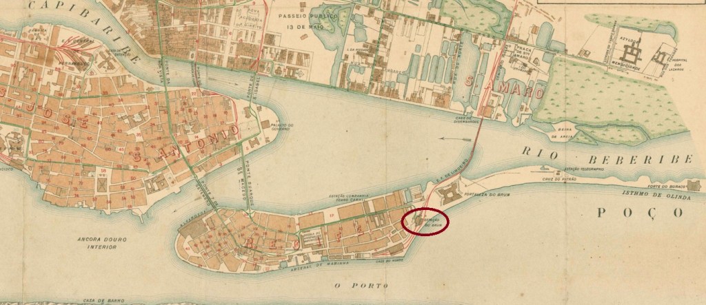
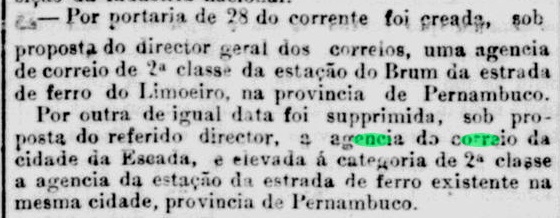
Brum station was inaugurated in October 1881 by the Great Western Railway Co. on Recife Island, opposite the centre of the Pernambuco capital. The railway line belonged to Rede Ferroviária do Nordeste from 1950 until its closure in 1975. The name Brum is said to come from the adjacent Brum fortress from 1630, which in turn was supposedly named after the Dutch governor Johann Bruyne (!). Today the rails are gone, the station building serves as a memorial to justice (Memorial da Justiça).
1906 (Photo: Sidney Correa in estacoesferroviarias.com.br)
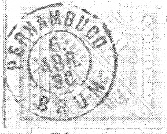
The station post office dates from September 1881 and is thus even slightly older than the station itself, as reported by the Rio press:
Jornal do Commercio/RJ, 30.09.1881
The oldest postmark is said to be BPE-0135a, which was used until about 1887 and is already known through R. Koester (Carimbologia VI):
BPE-0135a (RK) 1881-1887
It was followed by BPE-0135b (fig. from the internet), which was in use from ca. 1883:
BPE-0135b (EB) 1883ff-1885ff
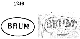
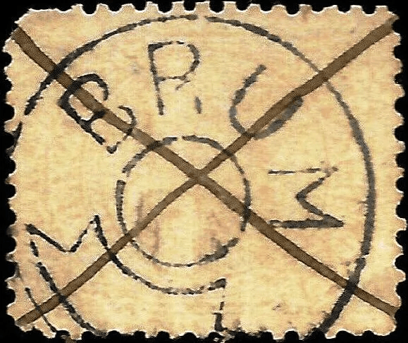
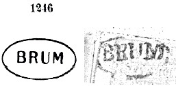
At about the same time BPE-0135c came out, presented by Paulo Ayres (Catálogo de Carimbos Brasil-Império, S. Paulo, 1937, 1942) with no. 1246. However, this image shows considerable differences when compared with Koester’s image:
BPE-0135c (P.A. 1246 – recte RK) 1883ff-1890ff
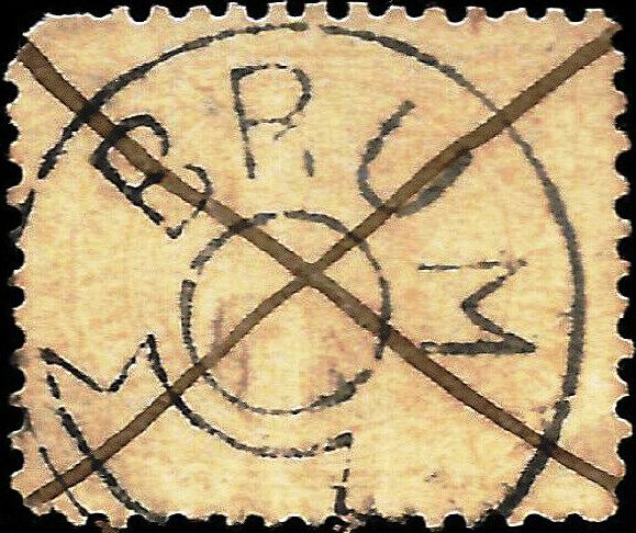
Next came BPE-0135d, used between 1889 and 1893 and also presented by Koester:
BPE-0135d (RK) 1889-1893
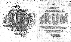
Paulo Ayres (op. cit.) also shows a Brum cancel on p. 120, which could not be confirmed so far:
(P.A. p. 120)Recife, 1856
Der Bahnhof Brum wurde im Oktober 1881 durch die Great Western Railway Co. eingeweiht und lag auf der Recife-Insel, gegenüber dem Zentrum der Pernambuco-Hauptstadt. Die Bahnlinie gehörte 1950 bis zur Stilllegung 1975 der Rede Ferroviária do Nordeste. Der Name Brum soll von der nebenan liegenden Brum-Festung aus 1630 kommen, die wiederum angeblich nach dem holländischen Gouverneur Johann Bruyne (!) genannt wurde. Heute sind die Schienen weg, das Bahnhofsgebäude dient als eine Justiz-Gedenkstätte (Memorial da Justiça).
1906 (Foto: Sidney Correa in estacoesferroviarias.com.br)
Das Bahnhofspostamt ist aus September 1881 und damit sogar etwas älter als der Bahnhof selber, wie die Presse aus Rio berichtete:
Jornal do Commercio/RJ, 30.09.1881
Der älteste Poststempel sollBPE-0135a sein, der bis ca. 1887 verwendet wurde und schon durch R. Koester (Carimbologia VI) bekannt ist:
BPE-0135a (RK) 1881-1887
Ihm folgte BPE-0135b (Abb. aus dem Internet), der ab ca. 1883 in Gebrauch war:
BPE-0135b (EB) 1883ff-1885ff
Etwa gleichzeitig kam BPE-0135c heraus, der durch Paulo Ayres (Catálogo de Carimbos Brasil-Império, S. Paulo, 1937, 1942) mit Nr. 1246 präsentiert wurde. Allerdings zeigt diese Abbildung erhebliche Unterschiede, wenn man sie mit Koesters Bild vergleicht:
BPE-0135c (P.A. 1246 – recte RK) 1883ff-1890ff
Danach kam BPE-0135d, der zwischen 1889 und 1893 verwendet und ebenfalls von Koester vorgestellt wurde:
BPE-0135d (RK) 1889-1893
Paulo Ayres (op. cit.) zeigt darüber hinaus auf S. 120 einen Brum-Stempel, der bisher nicht bestätigt werden konnte:
Villiers de l’Ile Adam: Carta (…) da Provincia de S. Paulo, 1847
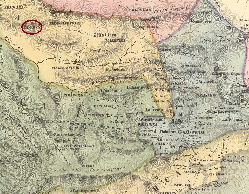
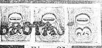
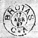
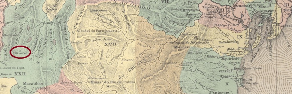
The Freguesia of Nosso Senhor das Dores de Brotas was founded in March 1846 on the north bank of the Jacaré-Pepira River in the Município of Araraquara, 240 km northwest of the provincial capital of São Paulo. In March 1853, the freguesia changed to the Município of Rio Claro, in February 1859 it was promoted to vila, and in March 1894 to town.
As Nova Monteiro writes in Administrações e Agencias Postaes do Brasil Imperio (Brasil Filatelico/RJ, 1934-5; Reprint SPP 1994-1999), there was a post office there since January 1855, which is confirmed by Aureo G. Santos in Agências de Correio Criadas e Suprimidas 1851, 1855, 1856 e 1857 (Brasil Filatélico 181, Rio de Janeiro, 1977):
Aureo G. Santos (op. cit.)
The first postmark is BSP-0190a, used until at least 1878 and known through R. Koester (Carimbologia VI).
BSP-0190a (RK) 1855-1878
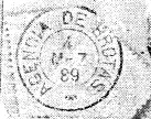
It was followed by the double circle BSP-0190b (image by Mário Celso Orsi Jr.), with the upper inscription BROTAS and inner dates from 1878 to 1881. After that there came the French type BSP-0190c, which was also seen in blue and violet with dates 1883-1889 and already shown by Koester (op. cit.):
BSP-0190c (RK) 1883-1889
Koester also presented the successor stamp BSP-0190d showing inner dates from 1888 to at least 1890:
BSP-0190d (RK)
In July 1885, a train station of the E.F. Rio Claro Railway Company was opened in Brotas. Although no evidence of the existence of a post office at the station has yet surfaced, the railway line was equipped with a postwagon, as the ambulatory postmark BSP-0191a (also known through Koester) can attest:
BSP-0191a (RK) 1887-1890
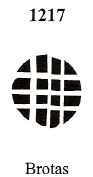
Two mute cancellations and a handwritten one from Brotas are also known. Philatelist Mário Celso Orsi Jr has reported the following mute cancellation on an 1878 item:
1878 (MO)
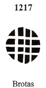
James Dingler and Klerman W. Lopes have recorded this mute cancel under no. 1217 in Mute Cancellations of the Brazil Empire/ Carimbos Mudos do Brasil Império (Brazil Philatelic Association, Rio de Janeiro, 2000):
BPA 1217, 1882ff
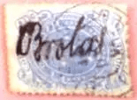
Finally, this handwritten cancellation comes from the Jorge L. Pedreira collection:
1890f (JLP)Atlas do Imperio do Brasil, 1868
Die Freguesia von Nosso Senhor das Dores de Brotas wurde im März 1846 gegründet und lag am Nordufer des Flusses Jacaré-Pepira im Município von Araraquara, 240 km nordwestlich der Provizhauptstadt São Paulo entfernt. Im März 1853 wechselte die Freguesia zum Município von Rio Claro, im Februar 1859 erfolgte der Aufstieg zur Vila, und im März 1894 zur Stadt.
Wie Nova Monteiro in Administrações e Agencias Postaes do Brasil Imperio (Brasil Filatelico/RJ, 1934-5; Reprint SPP 1994-1999) schreibt, gab es dort ein Postamt seit Januar 1855, was durch Aureo G. Santos in Agências de Correio Criadas e Suprimidas 1851, 1855, 1856 e 1857 (Brasil Filatélico 181, Rio de Janeiro, 1977) bestätigt wird:
Aureo G. Santos (op. cit.)
Der erste Poststempel ist BSP-0190a, der bis mindestens 1878 gebraucht wurde und durch R. Koester (Carimbologia VI) bekannt ist.
BSP-0190a (RK) 1855-1878
Ihm folgte der Doppelkreis BSP-0190b (Abb. Mário Celso Orsi Jr.), mit der oberen Inschrift BROTAS und inneren Daten von 1878 bis 1881. Danach kam der französische Typus BSP-0190c (RK), der bisher auch in Blau und Violett mit Daten 1883-1889 zu sehen war und bereits durch Koester (op. cit.) gezeigt wurde:
BSP-0190c (RK) 1883-1889
Koester stellte auch den Nachfolgestempel BSP-0190d vor, der innere Daten von 1888 bis mindestens 1890 aufweist:
BSP-0190d (RK)
Im Juli 1885 wurde in Brotas der Bahnhof der E.F. Rio Claro Bahngesellschaft eingeweiht. Auch wenn bisher kein Nachweis für die Existenz eines Postamts im Bahnhof auftauchte, war die Bahnlinie mit einem Postwagon ausgestattet, wie der ambulante Poststempel BSP-0191a (auch durch Koester bekannt) belegen kann:
BSP-0191a (RK) 1887-1890
Aus Brotas kennen wir auch zwei stumme Abstempelungen und eine handschriftliche postalische Entwertung. Der Philatelist Mário Celso Orsi Jr hat folgende stumme Entwertung auf einem Objekt aus dem Jahr 1878 gemeldet:
1878 (MO)
James Dingler und Klerman W. Lopes haben in Mute Cancellations of the Brazil Empire/ Carimbos Mudos do Brasil Império (Brazil Philatelic Association, Rio de Janeiro, 2000) diesen stummen Stempel unter der Nr. 1217 registriert:
BPA 1217, 1882ff
Schließlich aus der Sammlung Jorge L. Pedreira kommt diese handschriftliche Entwertung:
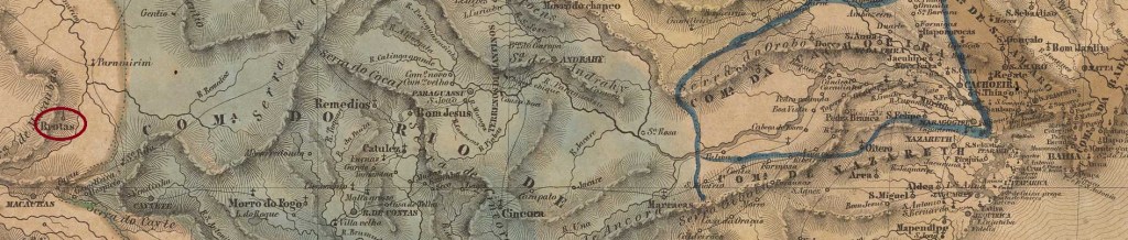
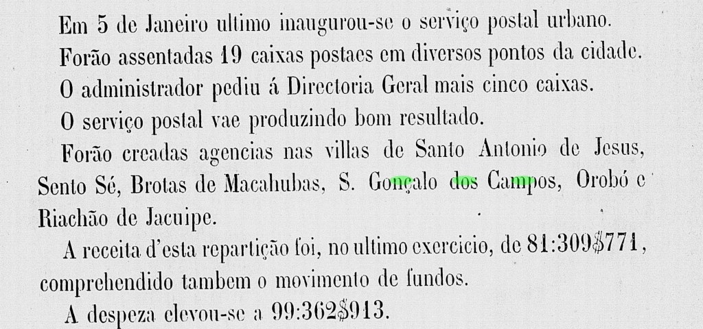
The freguesia of N. Sra.das Brotas was founded in March 1847 in the município of Macaúbas, located on the east bank of the river Riacho das Telhas, 610 km west of the provincial capital Salvador da Bahia. In July 1878, it was promoted to a villa as an agricultural colony, under the name Villa Agricola de N. Sra. das Brotas de Macaúbas. In June 1931 the place name was shortened to Brotas, but in December 1943 the old designation Brotas de Macaúbas returned.
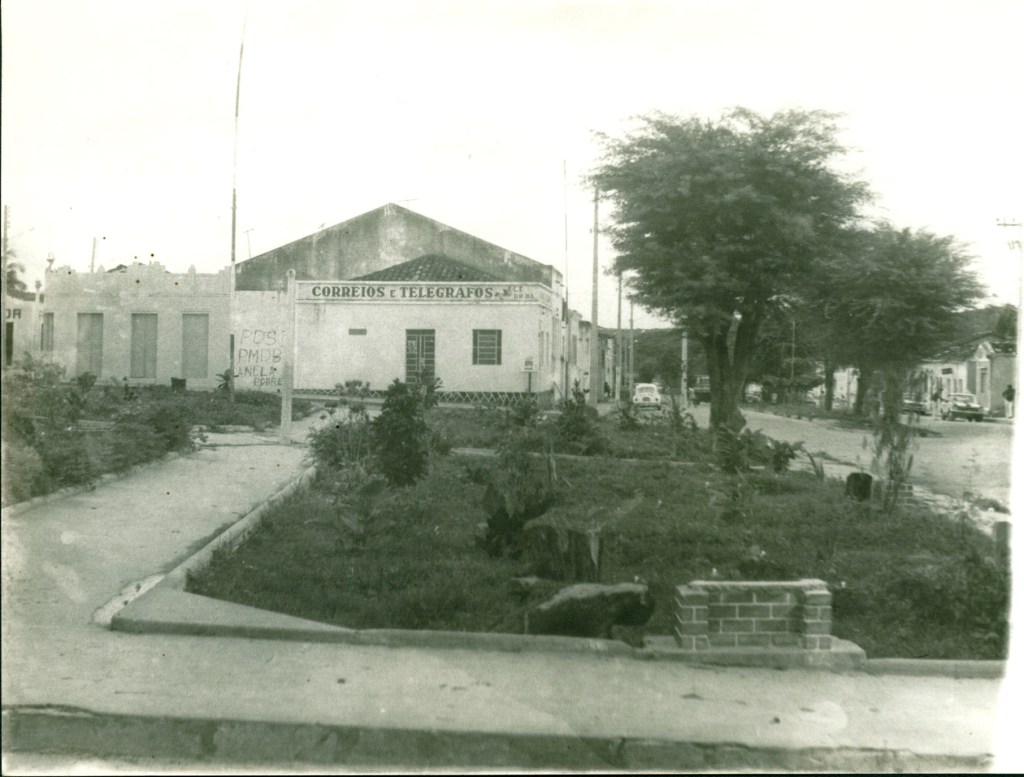
The post office, ca. 1980 (IBGE)
According to R. Koester (Carimbologia VI), there had been a post office there since July 1880, which is confirmed by the provincial president’s report for the following year:
Relatorio do Conselho Interino do Governo da Bahia, 1881
The oldest postmark so far is BBA-0170a (Coll. José L. Fevereiro): a simple double circle with the inscription BROTTAS DE MACAHUBAS on top, with internal dates from about 1888 to 1897.
Villiers de l’Ile Adam: Carta (…) da Provincia da Bahia, 1848
Anderer Name: Brotas
Die Freguesia von N. Sra. das Brotas wurde im März 1847 im Município von Macaúbas gegründet und lag am Ostufer des Flusses Riacho das Telhas, 610 km westlich der Provinzhauptstadt Salvador da Bahia entfernt. Im Juli 1878 erfolgte der Aufstieg zur Villa als Landwirtschaftskolonie, unter dem Namen Vila Agricola de N. Sra. das Brotas de Macaúbas. Im Juni 1931 wurde der Ortsname zu Brotas gekürzt, aber im Dezember 1943 kehrte die alte Bezeichnung Brotas de Macaúbas zurück.
Postamt, ca. 1908 (IBGE)
Laut R. Koester (Carimbologia VI) gab es dort ein Postamt seit Juli 1880. Das wird durch den Bericht des Provinzpräsidenten fürs folgende Jahr bestätigt:
Relatorio do Conselho Interino do Governo da Bahia, 1881
Der bisher älteste Poststempel ist BBA-0170a (Samml. José L. Fevereiro): ein schlichter Doppelkreis mit der Inschrift BROTTAS DE MACAHUBAS oben, mit inneren Daten von ca. 1888 bis 1897.
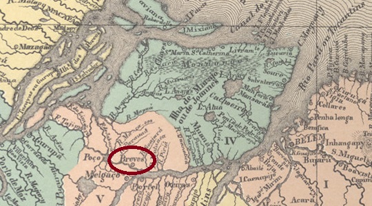
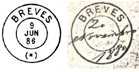
The Freguesia de N. Sra. de Sant’Anna dos Breves was founded in November 1850 on the east bank of the Breves River, 220 km west of the provincial capital Belém do Pará. The village was declared a vila in October 1851 and a town in November 1909. The place name comes from the first Portuguese landowners in the region, the brothers Manuel and Angelo Breves.
Two post office foundations have also been found here. First, in April 1850, as Nova Monteiro writes in Administrações e Agencias Postaes do Brasil Imperio (Brasil Filatelico/RJ, 1934-5; Reprint SPP 1994-1999). Then in 1856, as listed in the Directory of Imperial Post Offices (Tabella das Agencias do Correio do Imperio, Rio de Janeiro, 1885).
The oldest postmark so far is BPA-0055a, shown in R. Koester’s Carimbologia VI:
BPA-0055a (RK) 1876
It was followed by the imitation of a French type BPA-0055b, which was found with dates from about 1877 to 1889. The postmark can be seen in Catálogo de Carimbos Brasil-Império (S. Paulo, 1937, 1942) by Paulo Ayres on p. 120, but the illustration shows small deviations when compared with the picture from the Samml. Jorge L. Pedreira:
BPA-0055b (P.A. p. 120, recte JP) 1877ff-1889Villiers de l’Ile Adam: Carta (…) das Provincias do Gram Para e Alto Amazonas, 1850
Die Freguesia de N. Sra. de Sant’Anna dos Breves wurde im November 1850 gegründet und lag am Ostufer des Flusses Breves, 220 km westlich der Provinzhauptstadt Belem do Pará entfernt. Die Ortschaft wurde im Oktober 1851 zur Vila und im November 1909 zur Stadt erklärt. Der Ortsname kommt von den ersten portugiesischen Landbesitzern der Region, die Brüder Manuel und Angelo Breves.
Auch hier wurden zwei Postamtsgründungen gefunden. Erstens im April 1850, wie Nova Monteiro in Administrações e Agencias Postaes do Brasil Imperio (Brasil Filatelico/RJ, 1934-5; Reprint SPP 1994-1999) schreibt. Dann 1856, wie im Verzeichnis der kaiserlichen Postämter (Tabella das Agencias do Correio do Imperio, Rio de Janeiro, 1885) aufgelistet.
Der bisher älteste Poststempel istBPA-0055a, der in R. Koesters Carimbologia VI gezeigt wurde:
BPA-0055a (RK) 1876
Ihm folgte die Nachahmung eines französischen Typus BPA-0055b, der mit Daten von ca. 1877 bis 1889 zu finden war. Der Poststempel ist zwar in Catálogo de Carimbos Brasil-Império (S. Paulo, 1937, 1942) von Paulo Ayres auf S. 120 zu sehen, die Abbildung zeigt aber kleine Abweichungen, wenn man mit dem Bild aus der Samml. Jorge L. Pedreira vergleicht: