Categories
Carimbologia A-B

Barra de São João, Rio de Janeiro (BRJ-0130)

Atlas do Imperio do Brasil, 1868

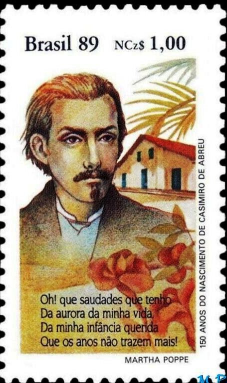
Other names: Indayassú, Casimiro de Abreu (1925)

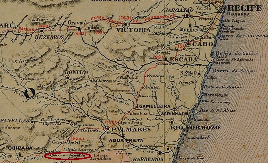
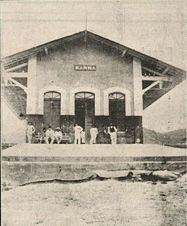
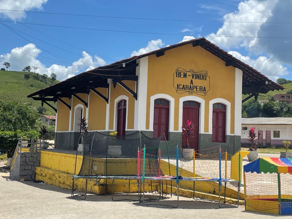
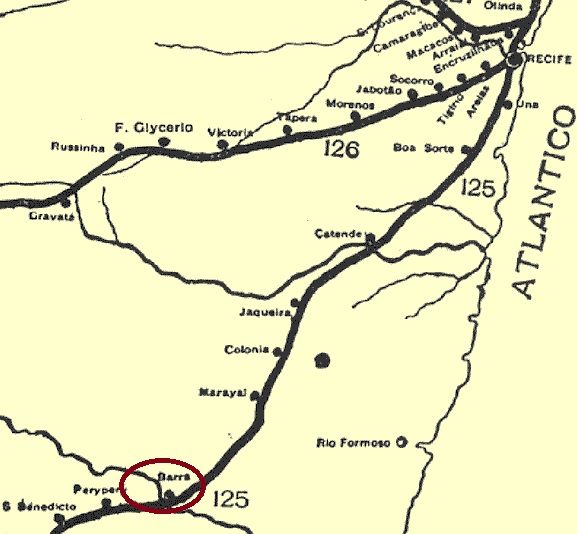
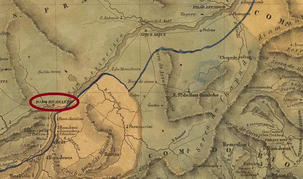
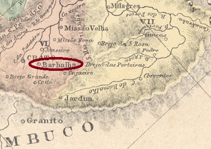
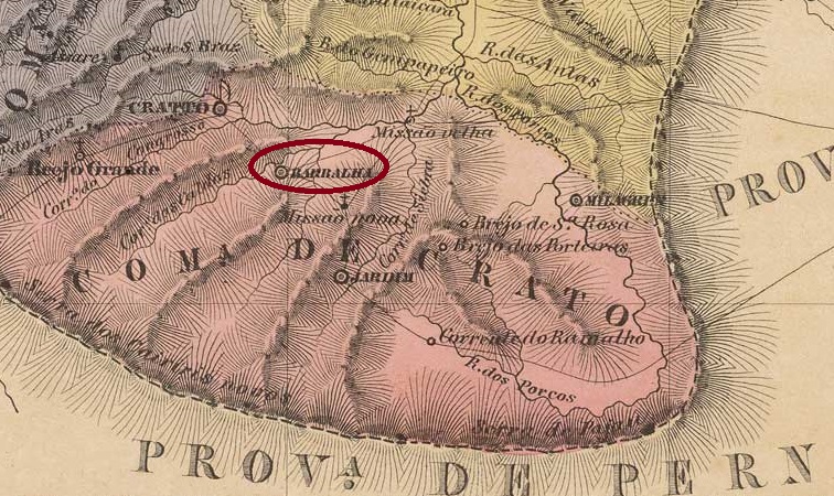
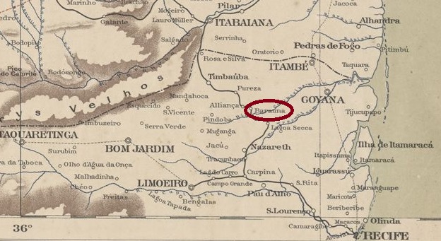
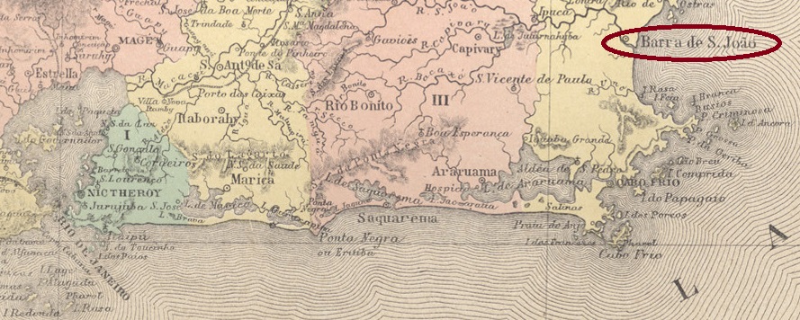
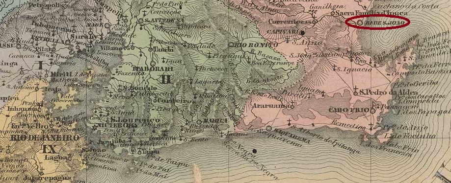
The freguesia of Barra de S. João was founded in 1800 and was located close to the north bank of the São João River in the territory of the Vila of Macaé, 130 km northeast of the capital Rio de Janeiro. In May 1846 it became a vila and in February 1890 a town, which has since changed its name three times: in December 1901 to Indayassú, in September 1904 back to Barra de S. João and in March 1938 to Casimiro de Abreu, which is still current today. The name is to commemorate the poet (1839-1860) who died young and was born in the region.

Scott 2211 Mi 2326 RHM C-1654

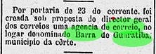
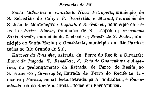
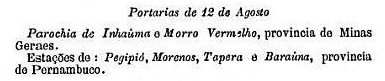
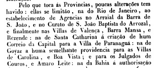
The local post office is dated March 1835, as Nova Monteiro writes in Administrações e Agencias Postaes do Brasil Imperio (Brasil Filatelico/RJ, 1934-5; reprint SPP 1994-1999). However, a local postal agency had already been mentioned a year earlier in the Imperial Ministry’s report:

Relatorio do Ministerio do Imperio, 1834 (p. 32)

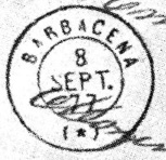
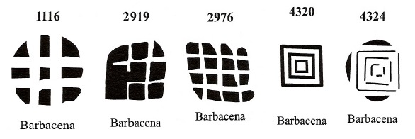
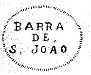
The first postmark is BRJ-0130a, used at least between 1839 and 1844 in the colours orange, blue and red, and known to us through R. Koester (Carimbologia III):

BRJ-0130a (RK)

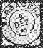
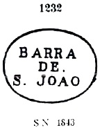
It was followed by the variant BRJ-0130b, with dates from about 1866 to 1871, occurs also in blue and violet, and was already presented by Paulo Ayres (Catálogo de Carimbos Brasil-Império, S. Paulo, 1937, 1942) under no. 1232:

BRJ-0130b (P.A. 1232)

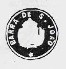
Then came BRJ-0130c, also known through P. Ayres (op.cit.), unfortunately without dates:

BRJ-0130c (P.A. p. 144)

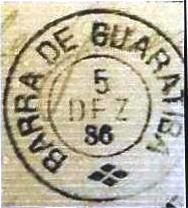
The last local cancel within the Empire is BRJ-0130d (fig. from the internet): a double circle with the inscription B. DE S. JOAO above and internal dates of 1888-1911.

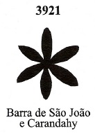
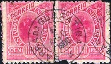
James Dingler and Klerman W. Lopes have also shown in Mute Cancellations of the Brazil Empire / Carimbos Mudos do Brasil Império (Brazil Philatelic Association, Rio de Janeiro, 2000) presented a mute cancellation from Barra de S. João under no. 3921:

BPA 3921, 1866ff
Villiers de l’Ile Adam: Carta (…) da Provincia do Rio de Janeiro, 1850

Andere Namen: Indayassú, Casimiro de Abreu (1925)

Die Freguesia von Barra de S. João wurde 1800 gegründet und lag nah am Nordufer des Flusses São João im Gebiet der Vila von Macaé, 130 km nordöstlich der Hauptstadt Rio de Janeiro entfernt. Im Mai 1846 wurde daraus eine Vila und im Februar 1890 eine Stadt, die ihren Namen seitdem dreimal gewechselt hat: im Dezember 1901 zu Indayassú, im September 1904 zurück zu Barra de S. João und im März 1938 zum heute noch aktuellen Casimiro de Abreu. Der Name soll an den jung verstorbenen Dichter (1839-1860), der in der Region geboren wurde.

Scott 2211 Mi 2326 RHM C-1654

Das örtliche Postamt ist vom März 1835, wie Nova Monteiro in Administrações e Agencias Postaes do Brasil Imperio (Brasil Filatelico/RJ, 1934-5; Reprint SPP 1994-1999) schreibt. Allerdings wurde bereits ein Jahr zuvor eine Postagentur vor Ort im Bericht des Imperialministeriums erwähnt:

Relatorio do Ministerio do Imperio, 1834 (S. 32)

Der erste Poststempel ist BRJ-0130a, der zumindest zwischen 1839 und 1844 in den Farben Orange, Blau und Rot verwendet wurde, und uns durch R. Koester (Carimbologia III) bekannt ist:

BRJ-0130a (RK)

Ihm folgte die Variante BRJ-0130b, die mit Daten von ca. 1866 bis 1871 einzutreffen ist, auch in Blau und Violett, und bereits durch Paulo Ayres (Catálogo de Carimbos Brasil-Império, S. Paulo, 1937, 1942) unter Nr. 1232 vorgestellt wurde:

BRJ-0130b (P.A. 1232)

Danach kam BRJ-0130c, der ebenfalls durch P. Ayres (op.cit.) bekannt ist, leider ohne Datumsangaben:

BRJ-0130c (P.A. S. 144)

Der letzte Ortsstempel aus dem Kaiserreich ist BRJ-0130d (Abb. aus dem Internet): ein Doppelkreis mit der Inschrift B. DE S. JOAO oben und inneren Daten von 1888-1911.

James Dingler und Klerman W. Lopes haben dazu in Mute Cancellations of the Brazil Empire / Carimbos Mudos do Brasil Império, (Brazil Philatelic Association, Rio de Janeiro, 2000) eine stumme Entwertung aus Barra de S. João unter der Nr. 3921 präsentiert :

BPA 3921, 1866ff
Categories
Carimbologia A-B

Barra de Santa Rita, Rio de Janeiro (BRJ-0125)

agenciaspostais.com.br

Barra de Santa Rita was a freguesia in the municipality of Magé, situated round 120 km north of the empire capital Rio de Janeiro. In May 1892 it was declared a district of the recently founded municipality of Theresopolis and has changed its name twice since then: in December 1938 to Paquequer Pequeno, and in April 1990 to Vale do Paquequer.

The local post office came into being in 1879, as can be read in the Directory of Imperial Post Offices (Tabella das Agencias do Correio do Imperio, Rio de Janeiro, 1885), but was closed in February 1886, as reported by the Rio press:

Diario de Noticias, 27.02.1886

So far, no imperial postmark has been seen from Barra de Santa Rita. There had been a post office called Santa Rachel (see SRJ-0883) in this freguesia between January and June 1874.

Mappa Geographico Postal 1906

Barra de Santa Rita war eine Freguesia im Município von Magé, die rund 120 km nördlich der kaiserlichen Hauptstadt Rio de Janeiro entfernt lag. Im Mai 1892 wurde sie ein Distrikt des kurz zuvor gegründeten Município von Theresopolis and hat seitdem den Ortsnamen zweimal gewechselt: im Dezember 1938 zu Paquequer Pequeno und im April 1990 zu Vale do Paquequer.

Das örtliche Postamt entstand 1879, wie im Verzeichnis der kaiserlichen Postämter (Tabella das Agencias do Correio do Imperio, Rio de Janeiro, 1885) zu lesen ist, und wurde allerdings im Februar 1886 geschlossen, wie die Presse aus Rio berichtet:

Diario de Noticias, 27.02.1886

Bisher wurde kein kaiserlicher Poststempel aus Barra de Santa Rita gesehen. In dieser Freguesia hatte es zwischen Januar und Juni 1874 ein Postamt namens Santa Rachel (siehe SRJ-0883) gegeben.

Categories
Carimbologia A-B

Barra de Guaratiba, Município Neutro (BMN-0060)

Mappa do Municipio Neutro, ca. 1875

Around 1750, the chapel of N. Sra. da Saúde da Barra de Guaratiba was built, which still stands between Sepetiba Bay and the Atlantic Ocean, 50 km west of the capital Rio de Janeiro.

literaturaeriodejaneiro.blogspot.com

The settlement around the chapel grew slowly, it belonged to the Freguesia of Guaratiba and has been a district of the administrative region of Guaratiba since July 1981. The name from the Tupi-guarani means many guarás. Guará is the Brazilian name for the Eudocimus ruber (Linnaeus 1758), a beautiful member of the family Threskiornithidae:

Photo: J. Patrick Fischer (CC BY-SA, 2016)

The local post office came into being in October 1883, according to the Rio Press:

Gazeta de Noticias, 25/10/1883

According to Paulo Novaes (agenciaspostais.com.br), the agency closed around 1948. The first postmark is BMN-0060a (Coll. Fuad Ferreira Fo), found so far with dates between 1884 and 1886 and can already be seen in agenciaspostais.com.br:

BMN-0060a (FF)

It was followed by BMN-0060b, which is probably Republican, as its dates go from 1900 to 1902:

BMN-0060b (PN)
Atlas do Imperio do Brasil, 1868

Um 1750 wurde die Kapelle von N. Sra. da Saúde da Barra de Guaratiba errichtet, die bis heute an der Straße zwischen der Bucht von Sepetiba und dem Atlantik liegt, 50 km westlich der Hauptstadt Rio de Janeiro.

literaturaeriodejaneiro.blogspot.com

Die Siedlung um die Kapelle wuchs langsam, sie gehörte der Freguesia von Guaratiba und ist seit Juli 1981 ein Ortsteil der Verwaltungsregion Guaratiba. Der Name aus dem Tupi-guarani bedeutet viele Guarás. Guará ist die bras. Bezeichnung für den Schlarlachsichler (Eudocimus ruber, Linnaeus 1758), ein schönes Mitglied der Familie Threskiornithidae:

Foto J. Patrick Fischer (CC BY-SA, 2016)

Das örtliche Postamt entstand im Oktober 1883, wie in der Rio-Presse zu lesen ist:

Gazeta de Noticias, 25.10.1883

Laut Paulo Novaes (agenciaspostais.com.br) wurde die Agentur um 1948 geschlossen. Der erste Poststempel ist BMN-0060a (Samml. Fuad Ferreira Fo), der bisher mit Daten zwischen 1884 und 1886 gefunden wurde und bereits in agenciaspostais.com.br zu sehen ist:

BMN-0060a (FF)

Ihm folgte BMN-0060b, der wohl in der Republik erschien, da seine Daten von 1900 bis 1902 gehen:

BMN-0060b (PN)

Categories
Carimbologia A-B

Barra da Jangada (train station/Bahnhof), Pernambuco (BPE-0065)

Carta Corographica da Provincia de Pernambuco, 1880

Barra de Jangada station (sometimes spelled “das Jangadas”) was inaugurated in June 1884 on the southern line of the E.F. Recife ao S. Francisco railway company, close to the south bank of the Piranji River in the Município of Quipapá, 160 km southwest of the provincial capital Recife. The railway line passed to the Great Western railway company in 1901 and to Rede Ferroviária do Nordeste in 1950. From 1975 until its closure in 1996, it belonged to Rede Ferroviária Federal S.A. (estacoesferroviarias.com.br). The station building has recently been restored.

Ca. 1916 (Photo: O Malho, in estacoesferroviarias.com.br)
2022 (Photo: Paulo Marconi, in estacoesferroviarias.com.br)

The village of Barra da Jangada was originally in the Freguesia of S. Benedito, which became the District of Iraci in December 1943 and 20 years later the District of Igarapeba in the newly created Município of S. Benedito do Sul.

As can be seen from Boletim Postal No. 7 (November 1889), there had been a station post office since October 1889, and thus just over two weeks before the end of the Empire of Brazil.

Dieses Bild hat ein leeres alt-Attribut; sein Dateiname ist bp_89-7.jpg

Boletim Postal, November 1889

So far, no imperial postmark of this station has been seen. If it exists, it is extremely rare.

Instituto Brasileiro de Geografia e Estatistica, 1898

Der Bahnhof Barra de Jangada (auch mal “das Jangadas” geschrieben) wurde im Juni 1884 auf der Südlinie der Bahngesellschaft E.F. Recife ao S. Francisco eingeweiht und lag nah am Südufer des Flusses Piranji im Município von Quipapá, 160 km südwestlich der Provinzhauptstadt Recife entfernt. Die Bahnlinie ging 1901 zur Great Western-Bahngesellschaft und 1950 zur Rede Ferroviária do Nordeste über. Von 1975 bis zur Stilllegung 1996 gehörte sie der Rede Ferroviária Federal S.A. (estacoesferroviarias.com.br). Das Bahnhofsgebäude wurde vor kurzem restauriert.

Ca. 1916 (Foto: O Malho, in estacoesferroviarias.com.br)
2022 (Foto: Paulo Marconi, in estacoesferroviarias.com.br)

Der Ort Barra da Jangada lag ursprünglich in der Freguesia von S. Benedito, die im Dezember 1943 zum Distrikt von Iraci und 20 Jahre später zum Distrikt von Igarapeba im neu gegründeten Município von S. Benedito do Sul wurde.

Wie aus dem Boletim Postal Nr. 7 (November 1889) hervorgeht, gab es ein Bahnhofspostamt seit Oktober 1889, und damit gut zwei Wochen vor dem Ende des Kaiserreichs Brasilien.

Boletim Postal, November 1889

Bisher wurde kein kaiserlicher Poststempel dieses Bahnhofs gesehen. Falls es ihn gibt, ist er äußerst selten.

Categories
Carimbologia A-B

Barra, Bahia (BBA-0105)

Villiers de l’Ile Adam: Carta (…) da Provincia da Bahia, 1848

Other names: Villa da Barra do Rio Grande, Barra (1931)

See also Villa da Barra (VBA-0775)

The Portuguese word Barra means, among others, a river mouth. This was the case in December 1752, when the freguesia of São Francisco das Chagas da Barra do Rio Grande do Sul was founded, almost 700 km west of the future provincial capital Salvador. One should remember firstly that the locality was still in Pernambuco at that time because the entire left bank of the São Francisco River up to the border with the Capitania of Minas Gerais still belonged to Pernambuco until the failed revolution in 1817. And secondly, Rio Grande do Sul here has nothing to do with the province of the same name in the extreme south of the country, but refers to the Rio Grande, which rises on the border with Goiás and flows into the São Francisco, precisely at its barra.

As early as August 1753, the town was elevated to the status of Vila, but it was not until June 1873 – 120 years later – that Barra do Rio Grande became a town, and since June 1931 it has simply been called Barra.

Barra post office, ca. 1960 (Photo: IBGE)

Two creation years for the local post office have also been identified here. First in May 1832, as Nova Monteiro writes in Administrações e Agencias Postaes do Brasil Imperio (Brasil Filatelico/RJ, 1934-5; Reprint SPP 1994-1999). The next creation took place in September 1858, according to Reinhold Koester in Carimbologia III. The only postmark so far found for the 19. Century is BBA-0105b, (Coll. FM): a double circle with the inscriptions BARRA above and (BAHIA) below. Just one specimen was found, dated 1894ff in the centre.

For postmarks under VILLA DA BARRA see VBA-0775.

Atlas do Imperio do Brasil, 1868

Andere Namen: Villa da Barra do Rio Grande, Barra (1931)

Siehe auch Villa da Barra (VBA-0775)

Das portugiesische Wort Barra bedeutet unter anderen eine Flussmündung. So in diesem Fall, als im Dezember 1752 die Freguesia von São Francisco das Chagas da Barra do Rio Grande do Sul gegründet wurde, fast 700 km westlich der künftigen Provinzhauptstadt Salvador entfernt. Wobei erstens lag der Ort damals noch in Pernambuco, denn das gesamte linke Ufer des Flusses São Francisco bis zur Grenze zur Capitania von Minas Gerais gehörte bis zur missglückten Revolution 1817 noch zu Pernambuco. Und zweitens hat hier Rio Grande do Sul nichts mit der gleichnamigen Provinz in äußersten Süden des Landes zu tun, sondern bezieht sich auf den Rio Grande, der an der Grenze zu Goiás entspringt und in den São Francisco hineinfließt, eben an seiner Barra.

Bereits im August 1753 wurde der Ort zur Vila erhoben, aber erst im Juni 1873 – also 120 Jahre später – wurde Barra do Rio Grande eine Stadt, die seit Juni 1931 lediglich Barra heißt.

Postamt Barra, ca. 1960 (Foto: IBGE)

Zwei Gründungsjahre fürs örtliche Postamt wurden auch hier ermittelt. Erstmals im Mai 1832, wie Nova Monteiro in Administrações e Agencias Postaes do Brasil Imperio (Brasil Filatelico/RJ, 1934-5; Reprint SPP 1994-1999) schreibt. Dann wieder im September 1858, laut Reinhold Koester in Carimbologia III. Der bisher einzige Poststempel im 19. Jahrhundert ist BBA-0105b, (Samml. FM): ein Doppelkreis mit den Inschriften BARRA oben und (BAHIA) unten. Ein Exemplar gefunden, datiert 1894ff in der Mitte.

Für Poststempel unter VILLA DA BARRA siehe VBA-0775.

Categories
Carimbologia A-B

Barcellos, Bahia (BBA-0100)

Villers de l’Ile Adam: Carta (…) da Provincia da Bahia, 1848

This old village was a Jesuit colony in the 17th century, beautifully situated on the Bay of Camamu, 220 km south of the later provincial capital Salvador da Bahia. In May 1758 it became a freguesia and vila called N. Sra. de Candeias de Barcellos, but towards the end of the 18th century it was demoted as a freguesia of the Vila of Camamu. It was promoted again to Vila until 1840, but after 1911 it was downgraded again, this time as a district, first called Santa Cruz e Barcellos, which since Novermber 1938 has been called Barcelos do Sul.

As Nova Monteiro points out in Administrações e Agencias Postaes do Brasil Imperio (Brasil Filatelico/RJ, 1934-5; Reprint SPP 1994-1999), there was a post office there since June 1856. So far, no Imperial postmark from this locality has appeared.

Atlas do Imperio do Brasil, 1868

Diese alte Ortschaft war im 17. Jahrhundert ein Jesuitendorf, wunderschön an der Bucht von Camamu gelegen, 220 km südlich der späteren Provinzhauptstadt Salvador da Bahia. Im Mai 1758 wurde daraus eine Freguesia und Vila namens N. Sra. de Candeias de Barcellos, die aber gegen Ende des 18. Jahrhunderts als Freguesia der Vila von Camamu degradiert wurde. Der Wiederaufstieg zur Vila erfolgte bis 1840, allerdings nach 1911 wurde der Ort nochmals herabgestuft, diesmal als ein Distrikt, der zunächst Santa Cruz e Barcellos hieß, seit Novermber 1938 heißt er Barcelos do Sul.

Wie Nova Monteiro in Administrações e Agencias Postaes do Brasil Imperio (Brasil Filatelico/RJ, 1934-5; Reprint SPP 1994-1999), gab es dort ein Postamt seit Juni 1856. Bisher ist kein kaiserlicher Poststempel aus dieser Ortschaft aufgetaucht.

Categories
Carimbologia A-B

Barcellos, Pará/Amazonas (BAM-0010)

Atlas do Imperio do Brasil, 1868

This locality was already declared a Vila in May 1758 and functioned as the capital of the former Capitania of Rio Negro until 1790. It was located on the south bank of the Rio Negro, 400 km northwest of the later capital Manaus. After Brazil’s independence in 1822, it belonged to the province of Grão-Pará until 1850, when the province of Amazonas was created. After that, Barcellos was twice downgraded as a freguesia or district of the Vila of Moura: in October 1878 and in November 1930. Subsequently came two upgrades as a vila in its own município: in June 1881 and in September 1931. Since August 1938, Barcelos (as it is written today) has been a city.

The post office in Barcelos, ca. 1970 (IBGE)

Three dates have been found for the emergence of the local post office, yet no imperial postmark. First in March 1829, as R. Koester writes in Carimbologia III. Then in March 1846, as one can read in Nova Monteiro’s Administrações e Agencias Postaes do Brasil Imperio (Brasil Filatelico/RJ, 1934-5; Reprint SPP 1994-1999). And finally in 1884 – that is, for the first time in the province of Amazonas, as can be seen from the Directory of Imperial Post Offices (Tabella das Agencias do Correio do Imperio, Rio de Janeiro, 1885).

So far, no postmark of the imperial period could be assigned to this locality.

Villiers de l’Ile Adam: Carta (…) das Provincias do Grão-Para e Alto Amazonas, 1850

Diese Ortschaft war bereits im Mai 1758 zur Vila erklärt und fungierte als Hauptstadt der ehemaligen Capitania von Rio Negro bis 1790. Sie lag am Südufer des Rio Negro, 400 km nordwestlich der späteren Hauptstadt Manaus entfernt. Nach der Unabhängigkeit Brasiliens 1822 gehörte sie der Provinz Grão-Pará bis 1850, als die Provinz Amazonas entstand. Danach wurde Barcellos zweimal als Freguesia bzw. Distrikt der Vila von Moura herabgestuft: im Oktober 1878 und im November 1930. In der Folge kamen zwei Aufstiege als Vila im eigenen Município: im Juni 1881 und im September 1931. Seit August 1938 ist Barcelos (wie man es heute schreibt) eine Stadt.

Das Postamt in Barcelos, ca. 1970 (IBGE)

Es wurden drei Zeitpunkte zur Entstehung des örtlichen Postamts gefunden, aber noch kein kaiserlicher Poststempel. Erstmals im März 1829, wie R. Koester in Carimbologia III schreibt. Dann im März 1846, wie man in Nova Monteiros Administrações e Agencias Postaes do Brasil Imperio (Brasil Filatelico/RJ, 1934-5; Reprint SPP 1994-1999) lesen kann. Und schließlich 1884 – also erstmals unter der Provinz Amazonas, wie aus dem Verzeichnis der kaiserlichen Postämter (Tabella das Agencias do Correio do Imperio, Rio de Janeiro, 1885) entnommen werden kann.

Bisher konnte kein Poststempel der Kaiserzeit dieser Ortschaft zugeordnet werden.

Categories
Carimbologia A-B

Barbalha, Ceará (BCE-0040)

Atlas do Imperio do Brasil, 1868

The parish of Santo Antonio da Barbalha was founded in August 1838 and was located near the Vila of Crato, 500 km south of the provincial capital Fortaleza. The place rose to the status of vila in August 1846 and town in August 1876.

As Nova Monteiro writes in Administrações e Agencias Postaes do Brasil Imperio (Brasil Filatelico/RJ, 1934-5; Reprint SPP 1994-1999), there was a post office there since August 1866, but regional press reports postal routes had passed through Barbalha even before that date, at least between October 1849 and April 1865:

O Cearense, 15.10.1849
O Cearense, 18.04.1865

Since it is hard to imagine an honorary post office clerk at work for over 15 years, it could well be that a post office has operated there, however.

The only imperial postmark from Barbalha so far is BCE-0040a, already shown by Paulo Ayres in Catálogo de Carimbos Brasil-Império, (S. Paulo, 1937, 1942):

BCE-0040a (P.A. p. 145)

Later, BCE-0040c (fig. from the internet) also appeared: a double circle with the inscriptions BARBALHO (sic!) above and (CEARÁ) below. The dates so far come from the period 1902-1903.

Villiers de l’Ile Adam: Carta (…) da Provincia do Ceara, 1849

Die Pfarrei von Santo Antonio da Barbalha wurde im August 1838 gegründet und lag bei der Vila von Crato, 500 km südlich der Provinzhauptstadt Fortaleza entfernt. Der Ort stieg im August 1846 zur Vila und im August 1876 zur Stadt auf.

Wie Nova Monteiro in Administrações e Agencias Postaes do Brasil Imperio (Brasil Filatelico/RJ, 1934-5; Reprint SPP 1994-1999) schreibt, gab es ein Postamt dort seit August 1866. In der Regionalpresse liest man aber, dass Postrouten durch Barbalha schon vorher, zumindest zwischen Oktober 1849 und April 1865 gingen:

O Cearense, 15.10.1849
O Cearense, 18.04.1865

Da es ein Ehrenamt als Postangestellter über 15 Jahre lang schwer vorstellbar ist, könnte es gut sein, dass ein Postamt dort wie auch immer betrieben wurde.

Der bisher einzige kaiserliche Poststempel aus Barbalha ist BCE-0040a, der bereits durch Paulo Ayres in Catálogo de Carimbos Brasil-Império, (S. Paulo, 1937, 1942) gezeigt wurde:

BCE-0040a (P.A. S. 145)

Später erschien auch BCE-0040c (Abb. aus dem Internet): ein Doppelkreis mit den Inschriften BARBALHO (sic!) oben und (CEARÁ) unten. Die Daten kommen bisher aus dem Zeitraum 1902-1903.

Categories
Carimbologia A-B

Barbacena, Minas Gerais (BMG-0220)

Atlas do Imperio do Brasil, 1868

Other names: Capela da Borda do Campo, Igreja Nova

The freguesia of N. Sa. da Piedade da Borda do Campo was created by royal decree in 1725, located 130 km south of the Capitania capital Vila Rica (later: Ouro Preto). Between 1748 and 1752 (sources disagree), the parish moved to the neighbouring Igreja Nova, which at that time belonged to the Vilas of S. José and S. João d’El-Rei. Then, in August 1791, the ascension to a vila took place, called Barbacena, as the then governor of the Capitania of Minas Gerais was the Vicomte de Barbacena. Its name in turn came from a small town in the upper Alentejo in Portugal (662 inhabitants in 2011). Barbacena has been a town in Minas Gerais since March 1840.

Four dates have been found for the creation of the local post office, a sure indication that it was closed in between. First in May 1809, as Paula Sobrinho writes in História Postal de Minas Gerais (Belo Horizonte, 1997). Then in March 1829, as one can read in Nova Monteiro’s Administrações e Agencias Postaes do Brasil Imperio (Brasil Filatelico/RJ, 1934-5; Reprint SPP 1994-1999). Then again in October 1833, as noted both in the Postal Report (Relatorio Postal) for 1887 and in the Directory of Imperial Post Offices (Tabella das Agencias do Correio do Imperio, Rio de Janeiro, 1885). And finally in June 1838, as Paula Sobrinho (op. cit.) also noted.

The first postmark is BMG-0220a, which also occurs in sepia and was used between 1818 and at least 1843. A frameless variant of this cancel is also said to exist. However, all illustrations so far show clear remnants of the cancel frame. The postmark became known through the RHM catalogue, under P-MG-09:

BMG-0220a (RHM P-MG-09)

It was followed by BMG-0220b, in use around 1843, also occurring in sepia and listed both in the Paulo Ayres’s Catálogo de Carimbos Brasil-Império (S. Paulo, 1937, 1942) under no. 1228 and in the RHM catalogue as well:

BMG-0220b (P.A. 1228, RHM P-MG-07)

The next three postmarks are double circles, as presented by R. Koester in Carimbologia III:

BMG-0220c (RK) 1874-1886, which also exists in green
BMG-0220d (RK) 1883-1884
BMG-0220e (RK) 1887-1891

In Mute Cancellations of the Brazil Empire / Carimbos Mudos do Brasil Império (Brazil Philatelic Association, Rio de Janeiro, 2000) James Dingler and Klerman W. Lopes presented ten mute cancellations from the imperial Barbacena:

BPA 855 (P.A. 171) – 868 (P.A. 173, 1866ff-1878) – 1045 – 1104 – 1113 (P.A. 265)
BPA 1116 – 2919 – 2976 (P.A. 245) – 4320 (P.A. 526, 1866ff-1867) – 4324

Another mute cancellation was shown by R. Koester (op. cit.):

1867 (RK)
Villiers de l’Ile Adam: Carta (…) da Provincia de Minas Geraes, 1849

Andere Namen: Capela da Borda do Campo, Igreja Nova

Die Freguesia von N. Sa. da Piedade da Borda do Campo entstand 1725 durch königliche Verfügung und lag 130 km südlich der Capitania-Hauptstadt Vila Rica (später: Ouro Preto). Zwischen 1748 und 1752 (die Quellen sind sich nicht einig) wechselte die Pfarrei zur benachbarten Igreja Nova, die damals den Vilas von S. José und S. João d’El-Rei angehörte. Im August 1791 erfolgte dann der Aufstieg zu einer Vila, die Barbacena hieß, da der damalige Gouverneur der Capitania von Minas Gerais der Vicomte de Barbacena war. Sein Name wiederum kam von einer kleinen Gemeinde am oberen Alentejo in Portugal (662 Einwohner im Jahr 2011). Seit März 1840 ist Barbacena in Minas Gerais eine Stadt.

Es wurden vier Daten für die Entstehung des örtlichen Postamts gefunden, ein sicheres Indiz dafür, dass es zwischendurch geschlossen war. Erstmals im Mai 1809, wie Paula Sobrinho in História Postal de Minas Gerais (Belo Horizonte, 1997) schreibt. Dann im März 1829, wie man im Nova Monteiros Administrações e Agencias Postaes do Brasil Imperio (Brasil Filatelico/RJ, 1934-5; Reprint SPP 1994-1999) lesen kann. Dann wieder im Oktober 1833, wie sowohl im Postbericht (Relatorio Postal) für 1887 als auch im Verzeichnis der kaiserlichen Postämter (Tabella das Agencias do Correio do Imperio, Rio de Janeiro, 1885) vermerkt. Und schließlich im Juni 1838, wie Paula Sobrinho (op. cit.) ebenfalls notierte.

Der erste Poststempel ist BMG-0220a, der auch in sepia vorkommt und zwischen 1818 und mindestens 1843 verwendet wurde. Von diesem Stempel soll auch eine rahmenlose Variante vorkommen. Allerdings zeigen bisher alle Abbildungen deutliche Reste des Stempelrahmens. Bekannt wurde der Poststempel durch den RHM-Katalog, unter P-MG-09:

BMG-0220a (RHM P-MG-09)

Ihm folgte BMG-0220b, der wohl um 1843 in Gebrauch war, auch in sepia vorkommt und sowohl im Paulo Ayres Catálogo de Carimbos Brasil-Império (S. Paulo, 1937, 1942) unter Nr. 1228 als auch im RHM-Katalog aufgelistet wurde:

BMG-0220b (P.A. 1228, RHM P-MG-07)

Die nächsten drei Poststempel sind Doppelkreise, die allesamt durch R. Koester in Carimbologia III vorgestellt wurden:

BMG-0220c (RK) 1874-1886, existiert auch in grün
BMG-0220d (RK) 1883-1884
BMG-0220e (RK) 1887-1891

In Mute Cancellations of the Brazil Empire / Carimbos Mudos do Brasil Império (Brazil Philatelic Association, Rio de Janeiro, 2000) haben James Dingler und Klerman W. Lopes zehn stumme Abstempelungen aus dem kaiserlichen Barbacena präsentiert :

BPA 855 (P.A. 171) – 868 (P.A. 173, 1866ff-1878) – 1045 – 1104 – 1113 (P.A. 265)
BPA 1116 – 2919 – 2976 (P.A. 245) – 4320 (P.A. 526, 1866ff-1867) – 4324

Eine weitere stumme Entwertung zeigte R. Koester (op. cit.):

1867 (RK)
Categories
Carimbologia A-B

Baraúna (train station/Bahnhof), Pernambuco (BPE-0060)

Sociedade Geológica e Mineralógica, 1910

Baraúna station was inaugurated in January 1883 by the Great Western Railway Company and was located close to the banks of the Sirgi River in the Município of Nazaré, 90 km northwest of the provincial capital Recife. Since July 1909, the surrounding area has belonged to the Município of Aliança. The railway line went to Rede Ferroviária do Nordeste in 1950, and from 1975 until its closure in 1996 it belonged to Rede Ferroviária Federal S.A. (estacoesferroviarias.com.br).  Today the station building is demolished, the rails are still there.

Photo Sidney Correia (estacoesferroviarias.com.br)

A station post office existed from August 1889, as can be read in the Boletim Postal of the following month:

Boletim Postal No. 5, September 1889

No imperial postmark from this station has been seen so far.

Rede Ferroviaria, 1898

Der Bahnhof Baraúna wurde im Januar 1883 durch die Great Western Bahngesellschaft eingeweiht und lag nah am Ufer des Flusses Sirgi im Município von Nazaré, 90 km nordwestlich der Provinzhauptstadt Recife entfernt. Seit Juli 1909 gehört die Umgebung zum Município von Aliança. Die Bahnlinie ging 1950 zur Rede Ferroviária do Nordeste, und von 1975 bis zur Stilllegung 1996 gehörte sie der Rede Ferroviária Federal S.A. (estacoesferroviarias.com.br).  Heute ist das Bahnhofsgebäude abgerissen, die Schienen sind noch da.

Foto Sidney Correia (estacoesferroviarias.com.br)

Ein Bahnhofspostamt gab es seit August 1889, wie im Boletim Postal des Folgemonats zu lesen ist:

Boletim Postal Nr. 5, September 1889

Bisher war kein kaiserlicher Poststempel aus diesem Bahnhof zu sehen.