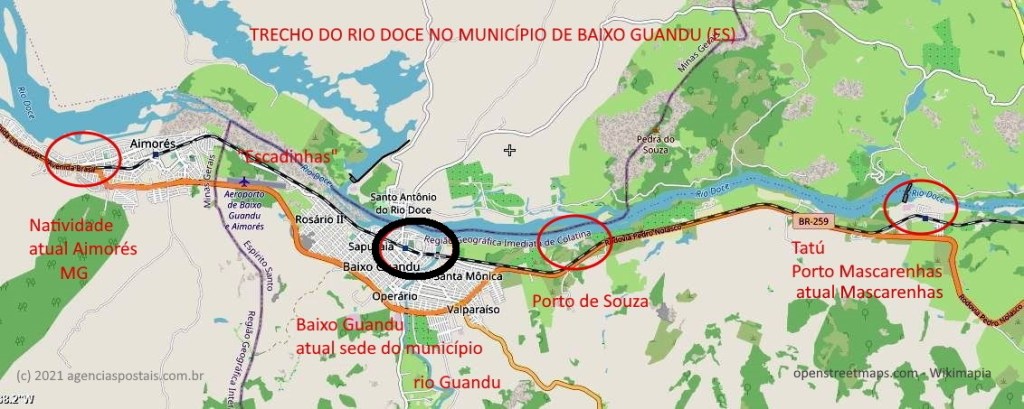
The settlement of Baixo Guandu was established around 1875 in the Município of Linhares and was located on the south bank of the Doce River, 180 km northwest of the provincial capital Vitória. The place officially became a colony in 1905 and a district in December 1915, changing to the município of Colatina six years later. Since April 1935, Baixo Guandu has been an independent município.
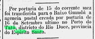
Reinhold Koester believed that the local post office was identical with Tatu (TES-0183). Recent research has nevertheless revealed that Baixo Guandu’s postal agency was Tatu’s successor when this agency was closed in December 1884, according to the Rio press:
O Paiz/RJ, 16.12.1884
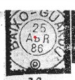
The imperial postmark is BES-0030a and was already presented by Koester in Carimbologia III:
BES-0030a (RK) 1886agenciaspostais.com.br
Die Siedlung Baixo Guandu entstand um 1875 im Município von Linhares und lag am Südufer des Flusses Doce, 180 km nordwestlich der Provinzhauptstadt Vitória entfernt. Der Ort wurde 1905 offiziell zu einer Kolonie und im Dezember 1915 zu einem Distrikt ernannt, der sechs Jahre später zum Município von Colatina wechselte. Seit April 1935 ist Baixo Guandu ein eigenständiger Município.
Reinhold Koester glaubte, dass das örtliche Postamt identisch mit Tatu (TES-0183) wäre. Neuere Forschungen haben dennoch ergeben, dass Baixo Guandus Postagentur die Nachfolgerin von Tatu war, als diese Agentur im Dezember 1884 geschlossen wurde, wie aus der Rio-Presse hervorgeht:
O Paiz/RJ, 16.12.1884
Der kaiserliche Poststempel ist BES-0030a und wurde bereits durch Koester im Carimbologia III vorgestellt:
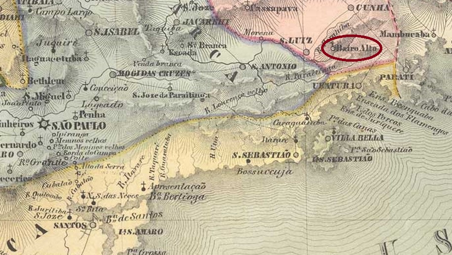
The settlement of N. Sra. da Conceição da Apparecida do Bairro Alto was located on the south bank of the Paraibuna River, 180 km east of the provincial capital of São Paulo. In March 1842, it became a freguesia in the Município of S. Luís do Paraitinga. This freguesia later changed jurisdiction twice: in June 1850 to Parahybuna and in April 1863 to Natividade, which has been called Natividade da Serra since November 1944.
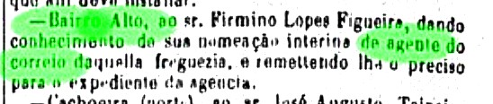
So far, it has not been possible to determine when a decision was made to establish a post office locally. However, this probably took place before April 1877, when the first postal employee was introduced by the regional press:
Correio Paulistano, 04.04.1877
No imperial postmark had yet been seen from this locality.
Villiers de l’Ile Adam: Carta (…) da Provincia de São Paulo, 1847
Die Siedlung N. Sra. da Conceição da Apparecida do Bairro Alto lag am Südufer des Flusses Paraibuna, 180 km östlich der Provinzhauptstadt São Paulo entfernt. Im März 1842 wurde daraus eine Freguesia im Município von S. Luís do Paraitinga. Diese Freguesia wechselte später zweimal die Zuständigkeit: im Juni 1850 zu Parahybuna und im April 1863 zu Natividade, der seit November 1944 Natividade da Serra heißt.
Bisher konnte nicht ermittelt werden, wann über die Einrichtung eines Postamts vor Ort entschieden wurde. Dies dürfte aber vor April 1877 stattgefunden haben, als der erste Postangestellter durch die Regionalpresse vorgestellt wurde:
Correio Paulistano, 04.04.1877
Noch war kein kaiserlicher Poststempel aus dieser Ortschaft gesehen.
Villiers de l’Ile Adam: Carta (…) das Provincias do Grão-Pará e Alto Amazonas, 1850
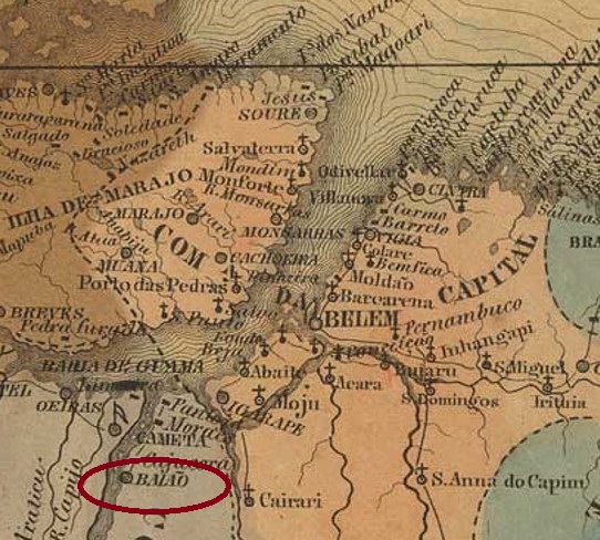
Another name: Vila Nova de Sto. Antonio do Tocantins
This village is said to have been a freguesia as early as 1758, called Tocantins and situated on the east bank of the river of the same name, 270 km southwest of the later provincial capital of Belém do Pará. In May 1833, the ascent to Vila Nova de Sto. Antonio do Tocantins, but its name was changed to Sto. Antonio de Baião, to pay homage to a village in the north of Portugal. Baião has been a town in the state of Pará since June 1895.
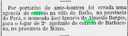
Two dates close to each other have been found for the origin of the local post office. Nova Monteiro writes April 1865 for it in Administrações e Agencias Postaes do Brasil Imperio (Brasil Filatelico/RJ, 1934-5; Reprint SPP 1994-1999), while the Rio press published the corresponding news three months later:
Correio Mercantil/RJ, 26.07.1865
So far, no imperial postmark from this locality has appeared.
Atlas do Imperio do Brasil, 1868
Anderer Name: Vila Nova de Sto. Antonio do Tocantins
Diese Ortschaft soll bereits 1758 eine Freguesia gewesen sein, die Tocantins hieß und am Ostufer des gleichnamigen Flusses lag, 270 km südwestlich der späteren Provinzhauptstadt Belém do Pará. Im Mai 1833 wurde der Aufstieg zur Vila Nova de Sto. Antonio do Tocantins verfügt, dessen Name aber im April 1841 zu Sto. Antonio de Baião wechselte, um einer Gemeinde im Norden Portugals die Ehre zu erweisen. Baião ist seit Juni 1895 eine Stadt im Bundesstaat Pará.
Zwei nah aneinander liegende Datum für die Entstehung des örtlichen Postamts wurden gefunden. Nova Monteiro schreibt dafür den April 1865 in Administrações e Agencias Postaes do Brasil Imperio (Brasil Filatelico/RJ, 1934-5; Reprint SPP 1994-1999), während die Presse aus Rio die dementsprechende Meldung drei Monate später veröffentlichte:
Correio Mercantil/RJ, 26.07.1865
Bisher ist kein kaiserlicher Poststempel aus dieser Ortschaft aufgetaucht.
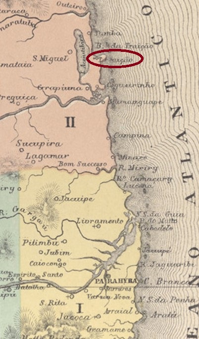
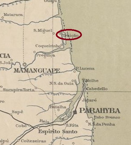
Other names: Bahia de Acajutibiró, Baía da Traição (1962)
See also São Miguel da Bahia da Traição (SPB-0215)
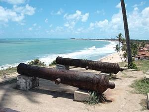
This village with the dramatic name (Bay of Treason) was as early as 1762 a freguesia of Mamanguape, which was located about 80 km north of the provincial capital Parahyba (today João Pessoa). The betrayal refers to the French invaders in the 16th century, who were apparently better able to deal with the Indians than the Portuguese. The Dutch later built a fortress there, of which today only a few cannons can be seen, which rust peacefully on the beach. Only in December 1908 the place became a district of Mamaguape, and since January 1962 it is the municipality of Baía da Traição.
Photo: Marcelo
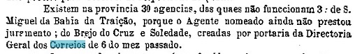
Two years of origin for the local post office were found. First in November 1882, as noted in the postal report (Relatorio dos Correios) for 1887. Then in 1884, as stated in the Directory of Imperial Post Offices (Tabella das Agencias do Correio do Imperio, Rio de Janeiro, 1885). It is possible that both dates are correct; the second is probably the date when the agency was put into operation. For as late as October 1883, the post office was still vacant, as the provincial president’s report tells us:
Relatorio do Presidente da Provincia, October 1883
Unfortunately, no imperial postmark has been sighted so far.
Serviço Geologico e Mineralogico do Brasil, 1910
Andere Namen: Bahia de Acajutibiró, Baía da Traição (1962)
Siehe auch São Miguel da Bahia da Traição (SPB-0215)
Diese Ortschaft mit dem dramatischen Namen (Bucht des Verrats) war bereits 1762 eine Freguesia von Mamanguape, die ca. 80 km nördlich der Provinzhauptstadt Parahyba (heute João Pessoa) entfernt lag. Der Verrat bezieht sich auf die französischen Invasoren im 16. Jahrhundert, die offenbar besser als die Portugiesen mit den Indianern umgehen konnten. Die Niederländer haben später dort eine Festung gebaut, von der heute nur noch ein paar Kanonen zu sehen sind, die friedlich am Strand vor sich hin rosten. Erst im Dezember 1908 stieg der Ort zum Distrikt von Mamaguape, und seit Januar 1962 ist er der Município von Baía da Traição.
Foto: Marcelo
Zwei Entstehungsjahre fürs örtliche Postamt wurden gefunden. Erstmals im November 1882, wie im Postbericht (Relatorio dos Correios) fürs Jahr 1887 vermerkt. Dann 1884, wie im Verzeichnis der kaiserlichen Postämter (Tabella das Agencias do Correio do Imperio, Rio de Janeiro, 1885) zu lesen ist. Möglicherweise sind beide Daten korrekt, das zweite dürfte die Inbetriebnahme der Agentur sein. Denn noch im Oktober 1883 war das Postamt vakant, wie der Bericht des Provinzpräsidenten uns sagt:
Relatorio do Presidente da Provincia, Oktober 1883
Bisher wurde leider kein Poststempel des Kaiserreichs gesichtet.
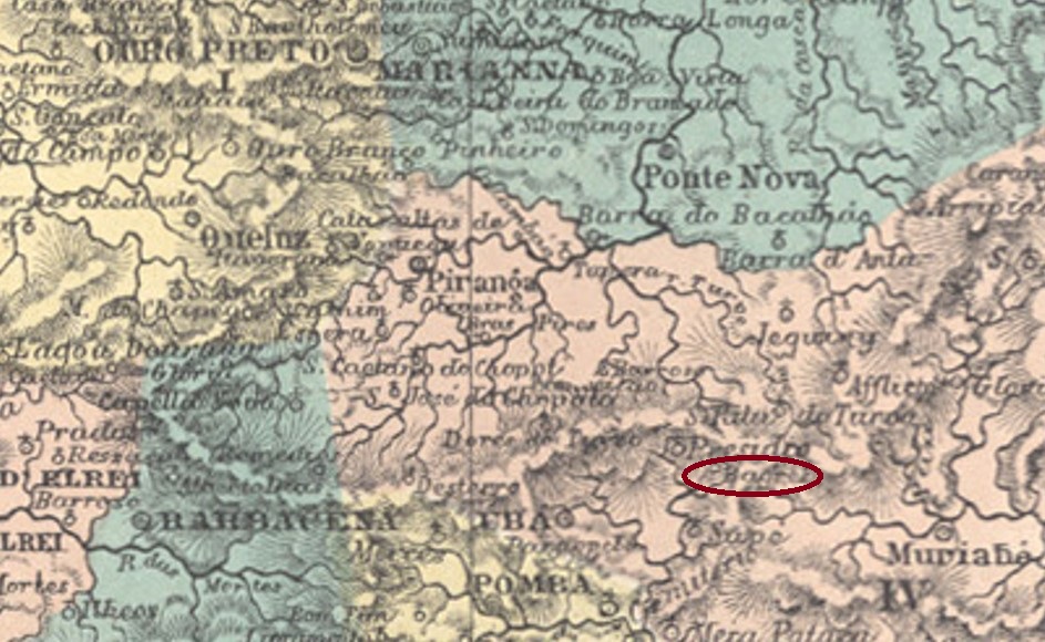
Other names: Sant’Anna de Bagres, Bagres do Rio Branco, Guiricema (1895)
The parish of N. Sa. da Encarnação dos Bagres (Our Lady of the Incarnation of the Catfish) was established in May 1856 in the Município of Ubá, located on the west bank of the Bagres River – a tributary of the Xopotó – 180 km southwest of the provincial capital Ouro Preto. In July 1872, the village was elevated to a district, which was assigned to the newly created município of Rio Branco in September 1881. In November 1895, the place name changed to Guiricema, which has been an independent município since December 1938. The name from the Tupi-Guarani language means many catfishes.
At least three dates of origin have been found for the local post office, the first two being close together. Paula Sobrinho writes May 1880 for it in História Postal de Minas Gerais (Belo Horizonte, 1997), while the postal report (Relatório Postal) indicates June of the same year. And Reinhold Koester (Carimbologia III) suggests a founding date of either March 1883 or March 1885.
The imperial postmark is BMG-0180a, which was in use between 1886 and 1891 and has already been shown by Paulo Ayres in Catálogo de Carimbos Brasil-Império (S. Paulo, 1937, 1942):
BMG-0180a (P.A. p. 120)
In the Republic came the successor stamp with the inscription BAGRES DO RIO BRANCO.
Provincia de Minas Geraes, 1873
Andere Namen: Sant’Anna de Bagres, Bagres do Rio Branco, Guiricema (1895)
Die Pfarrei von N. Sa. da Encarnação dos Bagres (Unsere Liebe Frau der Fleischwerdung der Welse) wurde im Mai 1856 im Município von Ubá errichtet und lag am Westufer des Flusses Bagres – einem Zufluss de Xopotó – 180 km südwestlich der Provinzhauptstadt Ouro Preto entfernt. Im Juli 1872 wurde die Ortschaft zu einem Distrikt erhoben, der im September 1881 dem neu gegründeten Município von Rio Branco zugewiesen wurde. Im November 1895 änderte sich der Ortsname zu Guiricema, der seit Dezember 1938 ein eigenständiger Município ist. Der Name aus der Tupi-Guarani-Sprache bedeutet viele Welse.
Es wurden mindestens drei Entstehungszeitpunkte fürs örtliche Postamt gefunden, wobei die ersten beiden eng beieinander liegen. Paula Sobrinho schreibt dafür den Mai 1880 in História Postal de Minas Gerais (Belo Horizonte, 1997), während der Postbericht (Relatório Postal) den Juni desselben Jahres angibt. Und Reinhold Koester (Carimbologia III) vermutet einen Gründungstermin entweder im März 1883 oder im März 1885.
Der kaiserliche Poststempel ist BMG-0180a, der zwischen 1886 und 1891 in Verwendung war und bereits durch Paulo Ayres in Catálogo de Carimbos Brasil-Império (S. Paulo, 1937, 1942) gezeigt wurde:
BMG-0180a (P.A. S. 120)
In der Republik kam der Nachfolgestempel mit der Inschrift BAGRES DO RIO BRANCO.
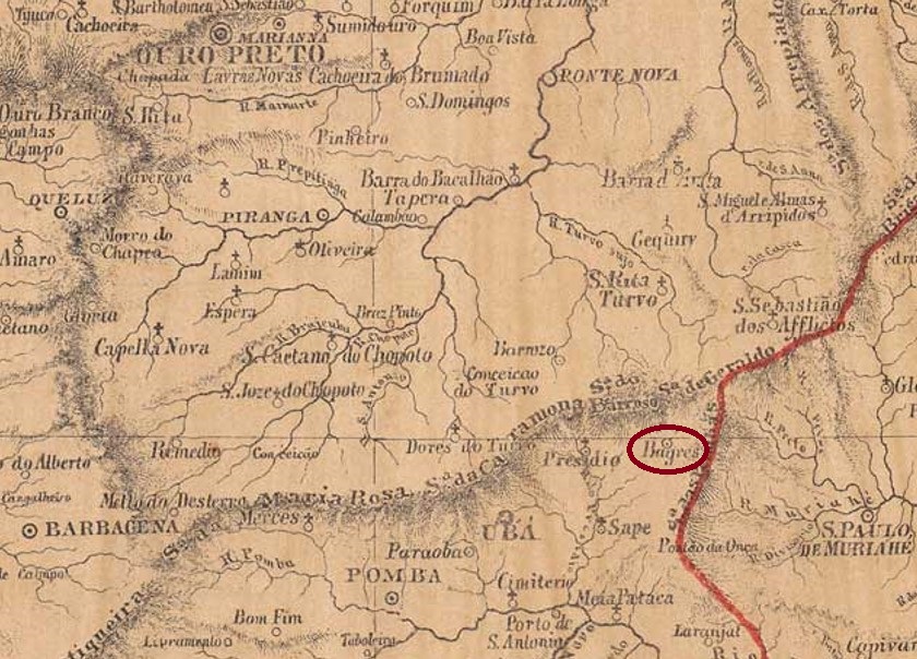
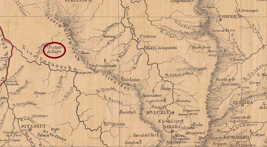
The parish of N. Sa. da Piedade do Bagre (Our Lady of the Piety of the Catfish) was established in April 1858 in the Município of Curvelo and was located on the north bank of the Bagre River, 280 km northwest of the provincial capital of Ouro Preto. Since December 1948, the village has been the municipal seat of Felixlândia. The name commemorates the priest Felix Ferreira da Rocha, who is said to have helped build a local chapel as early as April 1762.
The local post office was established in October 1880, as can be read in the postal report (Relatório dos Correios) for 1887. The agency was closed in April 1893 (Boletim Postal) and did not reopen until December 1903, as Paula Sobrinho writes in História Postal de Minas Gerais (Belo Horizonte, 1997). So far, no imperial postmark has been seen from this locality.
Provincia de Minas Geraes, 1873
Andere Namen: Piedade do Bagre, Felixlândia
Die Pfarrei von N. Sa. da Piedade do Bagre (Unsere Liebe Frau der Pietät des Welses) wurde im April 1858 im Município von Curvelo errichtet und lag am Nordufer des Flusses Bagre, 280 km nordwestlich der Provinzhauptstadt Ouro Preto entfernt. Seit Dezember 1948 ist der Ort Gemeindesitz von Felixlândia. Der Name erinnert an den Pfarrer Felix Ferreira da Rocha, der bereits im April 1762 eine Kapelle vor Ort mit gebaut haben soll.
Das örtliche Postamt entstand im Oktober 1880, wie man im Postbericht (Relatório dos Correios) für 1887 lesen kann. Die Agentur wurde im April 1893 geschlossen (Boletim Postal) und eröffnete erst im Dezember 1903 wieder, wie Paula Sobrinho in História Postal de Minas Gerais (Belo Horizonte, 1997) schreibt. Bisher wurde kein kaiserlicher Poststempel aus dieser Ortschaft gesehen.
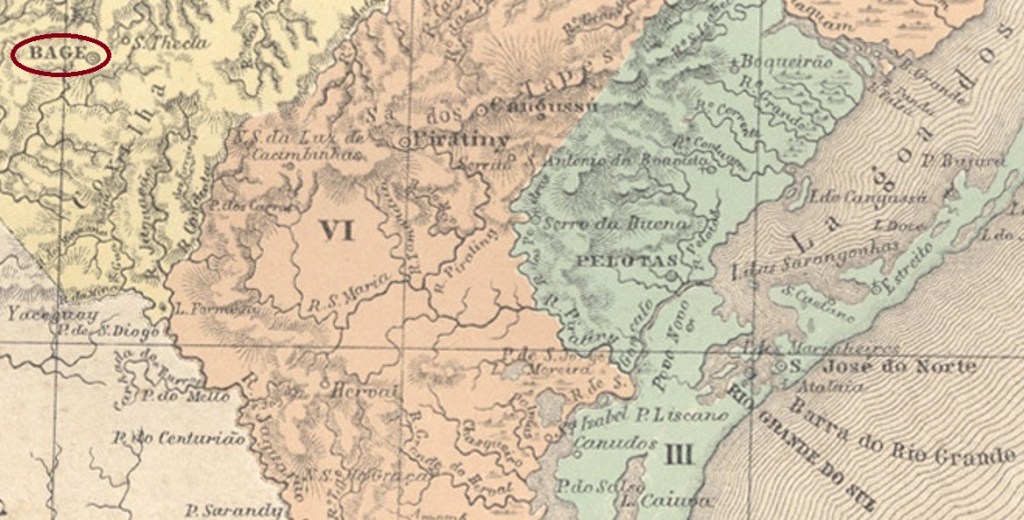
The settlement of Bagé began – as so often in border areas – as a soldiers’ camp, this time in July 1811 on the west bank of the Bagé stream, 380 km southwest of the later provincial capital Porto Alegre. Then, in January 1813, the chapel of S. Sebastião de Bagé was built, and by September 1815, the village had become a district to the Vila of Piratini. In June 1846 it was promoted to the status of Vila, and in December 1859 to the status of town.
Three dates for the emergence of the local post office have been found. First in October 1831, as Nova Monteiro writes in Administrações e Agencias Postaes do Brasil Imperio (Brasil Filatelico/RJ, 1934-5; reprint SPP 1994-1999). Then in 1833, as one can read in the Directory of Imperial Post Offices (Tabella das Agencias do Correio do Imperio, Rio de Janeiro, 1885). And finally, around 1845 – that is, after the end of the Farroupilha Revolution, as can be seen in the Annuario Politico, Historico e Estatistico (Yearbook of Politics, History and Statistics, 1846):
Annuario 1846, pp. 53-54
The first postmarks were therefore from the pre-philatelic period. BRS-0020a was already registered in the RHM catalogue under P-RS-01, unfortunately without giving the exact period of use:
BRS-0020a (RHM P-RS-01)
Its successor BRS-0020b (was also registered in the RHM, this time under P-RS-02, and was used from 1841 to at least 1843:
BRS-0020b (RHM P-RS-02)
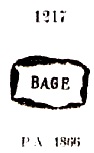
This was followed by a longer period without founded postmarks, and BRS-0020c was not registered until around 1866, then with dates until at least 1883. This postmark can be seen in Paulo Ayres’ Catálogo de Carimbos Brasil-Império, (S. Paulo, 1937, 1942) under no. 1217:
BRS-0020c (P.A. 1217)
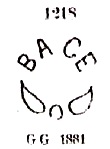
Then came the French type BRS-0020d (Fig. Fuad Ferreira Fo.): a double circle with the inscription BAGÉ above and the star between brackets below. A specimen found on a letter from 1879.From about 1881 also came the enigmatic BRS-0020e, also known through Ayres (op. cit.), this time under no. 1218:
BRS-0020e (P.A. 1218)
Bagé’s following postmarks were introduced to us by R Koester in Carimbologia III. BRS-0020f also occurs in dark purple and shows dates from 1881 to 1893:
BRS-0020f (RK)
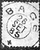
BRS-0020g was used between 1881 and 1885 and consists of two separated stamp lines, as the relative position of these is variable:
BRS-0020g (RK)
BRS-0020h (Collect. FM) is again a double circle with the inscription BAGÉ at the top, but compared to BRS-0020e, here the letters are smaller and there is no ornament at the bottom. Dates in the middle from 1889 to 1891. And BRS-0020i (fig. from the internet) should already be republican, as its inner dates so far are between 1891 and 1894. In this double circle one reads below (S. PEDRO DO SUL).
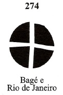
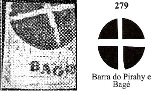
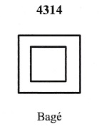
Four mute postmarks from Imperial Bagé were listed in Mute Cancellations of the Brazil Empire / Carimbos Mudos do Brasil Império (Brazil Philatelic Association, Rio de Janeiro, 2000) by James Dingler and Klerman W. Lopes:
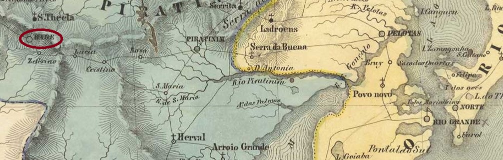
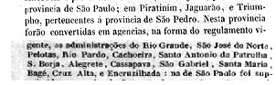
BPA 274BPA 279 (+ BRS-0020f/RK)BPA 4314 (1876ff-1879)BPA 4478 (P.A. 1041) 1883ffVilliers de l’Ile Adam: Carta (…) da Provincia de S. Pedro do Sul, 1847
Textaktualisierung am 6. Februar 2023
Die Siedlung Bagés begann – wie so oft in Grenzgebieten – als ein Soldatenlager, diesmal im Juli 1811 am Westufer des Bachs Bagé, 380 km südwestlich der späteren Provinzhauptstadt Porto Alegre. Im Januar 1813 wurde dann die Kapelle von S. Sebastião de Bagé errichtet, und schon im September 1815 war die Ortschaft ein Distrikt zur Vila von Piratini geworden. Im Juni 1846 erfolgte der Aufstieg zur Vila, und im Dezember 1859 zur Stadt.
Drei Zeitpunkte zur Entstehung des örtlichen Postamts wurden gefunden. Erstmals im Oktober 1831, wie Nova Monteiro in Administrações e Agencias Postaes do Brasil Imperio (Brasil Filatelico/RJ, 1934-5; Reprint SPP 1994-1999) schreibt. Dann 1833, wie man im Verzeichnis der kaiserlichen Postämter (Tabella das Agencias do Correio do Imperio, Rio de Janeiro, 1885) lesen kann. Und schließlich ca. 1845 – also nach dem Ende der Farroupilha-Revolution, wie aus dem Jahrbuch für Politik, Geschichte und Statistik (AnnuarioPolitico, Historico e Estatistico, 1846) hervorgeht:
Annuario 1846, S. 53-54
Die ersten Poststempel waren demnach aus der Vorphila-Zeit. BRS-0020a wurde bereits im RHM- Katalog unter P-RS-01 registriert, leider ohne den genauen Verwendungszeitpunkt zu nennen:
BRS-0020a (RHM P-RS-01)
Sein Nachfolger BRS-0020b (wurde ebenfalls im RHM eingetragen, diesmal unter P-RS-02, und wurde von 1841 bis mindestens 1843 gebraucht:
BRS-0020b (RHM P-RS-02)
Es folgte eine längere Zeit noch ohne gefundene Poststempel, und BRS-0020c wurde erst um 1866 registriert, dann mit Daten bis mindestens 1883. Dieser Stempel ist im Paulo Ayres‘ Catálogo de Carimbos Brasil-Império, (S. Paulo, 1937, 1942) unter Nr.1217 zu sehen:
BRS-0020c (P.A. 1217)
Danach kam der französischer Typ BRS-0020d (Abb. Fuad Ferreira Fo.): ein Dopplkreis mit der Inschrift BAGÉ oben und dem Stern zwischen Klammern unten. Ein Exemplar auf einem Brief aus 1879 gefunden. Ab ca. 1881 kam auch der rätselhafte BRS-0020e, der auch durch Ayres (op. cit.) bekannt ist, diesmal mit Nr. 1218:
BRS-0020e (P.A. 1218)
Die nächsten Poststempel Bagés wurden uns durch R Koester in Carimbologia III vorgestellt. BRS-0020f kommt auch in dunkellila vor und zeigt Daten von 1881 bis 1893:
BRS-0020f (RK)
BRS-0020g wurde zwischen 1881 und 1885 verwendet und besteht eigentlich aus zwei Stempelzeilen, da die relative Position derselben variabel ist:
BRS-0020g (RK)
BRS-0020h (Samml. FM) ist wieder ein Doppelkreis mit der Inschrift BAGÉ oben, aber im Vergleich zu BRS-0020e sind hier die Buchstaben kleiner, und unten ist kein Ornament zu sehen. Daten in der Mitte von 1889 bis 1891. Und BRS-0020i (Abb. aus dem Internet) dürfte bereits republikanisch sein, da seine inneren Daten bisher zwischen 1891 und 1894 liegen. In diesem Doppelkreis liest man unten (S. PEDRO DO SUL).
Vier stumme Poststempel aus dem kaiserlichen Bagé wurden im Mute Cancellations of the Brazil Empire / Carimbos Mudos do Brasil Império (Brazil Philatelic Association, Rio de Janeiro, 2000) von James Dingler und Klerman W. Lopes aufgelistet:
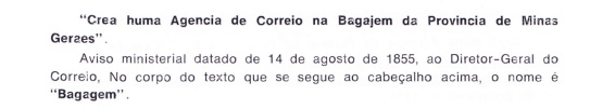
Other names: Diamantino da Bagagem, Estrela do Sul (1901)
The freguesia of Diamantino de N. Sra. Mãe dos Homens da Bagagem was founded in April 1854 on the west bank of the Bagagem River in the Município of Patrocínio, 590 km west of the provincial capital Ouro Preto. The place became a vila in May 1856 and a town in September 1861, which was named Estrela do Sul (South Star) exactly 40 years later. This was the name of the famous diamond that was discovered in the Bagagem River in July 1853 with over 250 carats. In the meantime, it has only barely 130 carats, but no less beautiful:
The Star of the South (copy: Reich der Kristalle Museum, Munich)
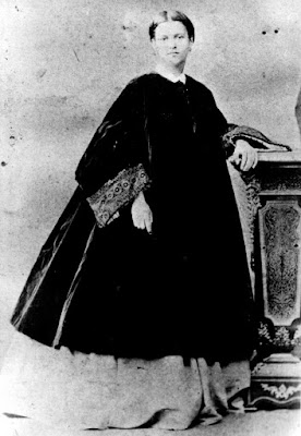
At least as famous and shrouded in mystery as the diamond is the most famous resident of Bagagem, the courtesan Ana Jacinta de São José (1800-1873), called Dona Beja:
Unknown photographer
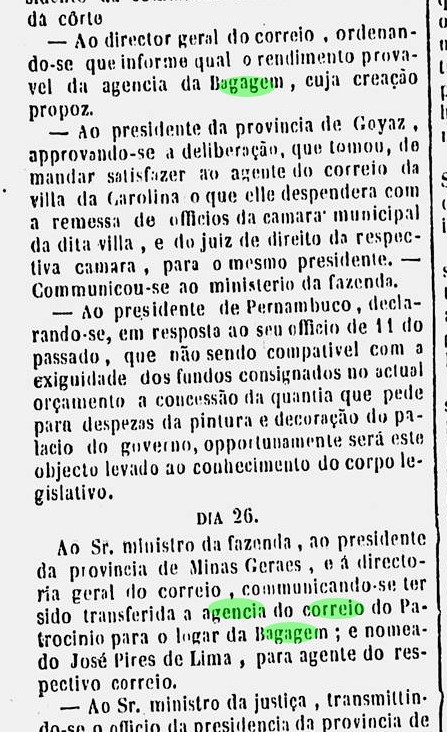
Four periods of operation for the local post office have been found so far, although it is not yet known when the first period began. However, it ended around 1851, when the agency was probably moved to the neighboring Patrocinio, as the official press announced the following year:
Relatorio do Ministerio do Imperio/1852
The reopening of the post office in Bagagem, however, was immediately detrmined in January 1852. Diamonds were discovered in the river and the post office moved back from Patrocínio’s villa to Bagagem, which was not even a freguesia at the time:
Diario do Rio de Janeiro, 24.02.1852
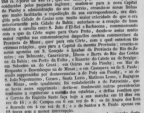
It is not known exactly when the second postal period ended, but it is likely to be after the discovery of the South Star. However, the third postal opening was decided in August 1855, as Aureo G. Santos writes in Agências de Correio Criadas e Suprimidas 1851, 1855, 1856 e 1857 (Brasil Filatélico 181, Rio de Janeiro, 1977):
Aureo G. Santos (op. cit.)
Finally, a fourth post opening was arranged in October 1860, as noted in the postal report (Relatorio Postal) for 1887.
The turbulent history of the town is reflected in its postmarks. The first one, for example, has not yet been found; it could even be that people had to make do without a postmark for decades. For Paulo Ayres shows in Catálogo de Carimbos Brasil-Império (S. Paulo, 1937, 1942) on p. 146 a handwritten cancellation that was in use from about 1866 until at least 1879:
P.A. p. 146
In the meantime, this cancellation even appeared on a stamp issue from 1844, but in connection with an unidentifiable postmark.
Coll. Paulo Corchaki
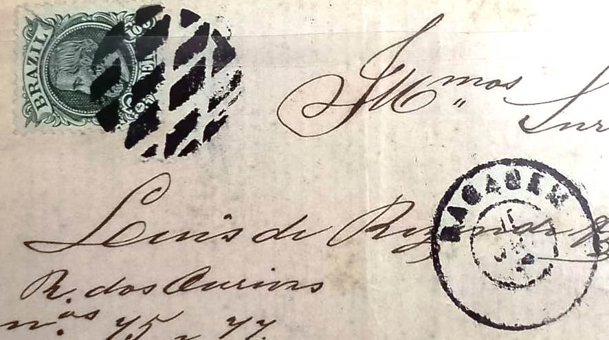
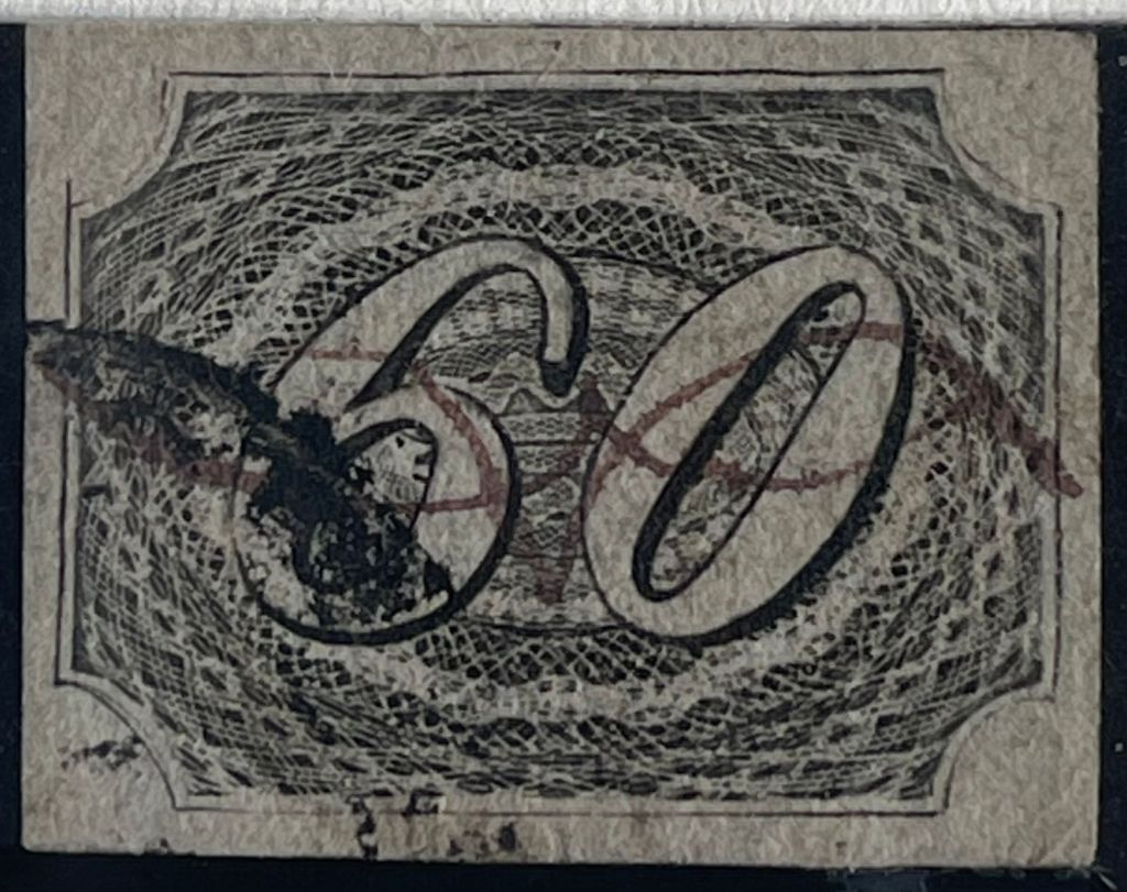
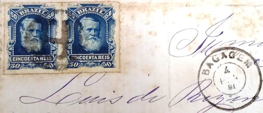
Whether this cancellation is a genuine one from Bagagem has yet to be verified. In any case, BMG-0175b (image from the Internet) is no fake: a double circle with the inscription BAGAGEM at the top, plus dates from 1878 to 1888. It was followed by BMG-0175c (coll. FM); in this double circle the inscription at the top is CID. DA BAGAGEM at the bottom, reading (M.G.), with dates from 1890 to 1893.
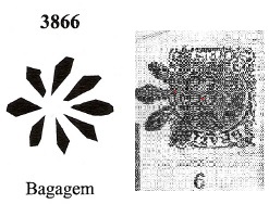
From Mute Cancellations of the Brazil Empire/ Carimbos Mudos do Brasil Império (Brazil Philatelic Association, Rio de Janeiro, 2000) from James Dingler and Klerman W. Lopes come two mute cancellations from Bagagem, with nos. 1793 and 3866:
BPA 1793 (FF) 1882BPA 3866 (RK) 1883
The philatelist Fuad Ferreira Fo. found two more mute cancellations, both from 1881, the first of which had already been made known by R. Koester (Carimbologia III) and could represent the initials of the postal agent:
And finally, Koester found another example of initials as mute cancel:
1881ff (RK)Estado de Minas Geraes, 1910
Andere Namen: Diamantino da Bagagem, Estrela do Sul (1901)
Die Freguesia von Diamantino de N. Sra. Mãe dos Homens da Bagagem wurde im April 1854 am Westufer de Flusses Bagagem (Gepäck) im Município von Patrocínio, 590 km westlich der Provinzhauptstadt Ouro Preto entfernt. Der Ort wurde im Mai 1856 eine Vila und im September 1861 eine Stadt, die genau 40 Jahre später Estrela do Sul (Südstern) genannt wurde. So hieß der berühmte Diamant, der im Juli 1853 mit über 250 Karat im Fluss Bagagem entdeckt wurde. Inzwischen ist er nur knapp 130 Karat groß, aber nicht weniger schön:
Der Stern des Südens (Kopie: Reich der Kristalle Museum, München)
Mindestens so berühmt und geheimnisumwittert wie der Diamant ist die bekannteste Bewohnerin von Bagagem, die Kurtisane Ana Jacinta de São José (1800-1873), genannt Dona Beja:
Unbekannter Fotograph
Es wurden bisher vier Betriebsperioden fürs örtliche Postamt gefunden, wobei noch nicht bekannt ist, wann die erste Periode begann. Sie endete aber um 1851, als die Agentur wohl zum benachbarten Patrocinio verlegt wurde, wie die Amtspresse im folgenden Jahr bekannt gab:
Relatorio do Ministerio do Imperio/1852
Die Wiedereröffnung des Postamts in Bagagem wurde aber gleich im Januar 1852 veranlasst. Da wurden Diamanten im Fluss entdeckt, und die Post zog von der Villa von Patrocínio zum Ort Bagagem zurück, der damals nicht einmal eine Freguesia war:
Diario do RJ, 24.02.1852
Es ist nicht bekannt, wann genau die zweite Postperiode endete, es dürfte aber erst nach der Entdeckung des Südsterns sein. Über die dritte Posteröffnung wurde aber im August 1855 entschieden, wie Aureo G. Santos in Agências de Correio Criadas e Suprimidas 1851, 1855, 1856 e 1857 (Brasil Filatélico 181, Rio de Janeiro, 1977) schreibt:
Aureo G. Santos (op. cit.)
Schließlich wurde eine vierte Posteröffnung im Oktober 1860 veranlasst, wie der Postbericht (Relatorio Postal) für 1887 notierte.
Die bewegte Geschichte des Orts spiegelt sich in seinen Poststempeln wider. So wurde der erste darunter bisher noch nicht gefunden; es könnte sogar sein, dass man jahrzehntelang ohne Poststempel auskommen musste. Denn Paulo Ayres zeigt in Catálogo de Carimbos Brasil-Império (S. Paulo, 1937, 1942) auf S. 146 eine handschriftliche Entwertung, die ab ca. 1866 bis mindestens 1879 Verwendung fand:
P.A. p/S. 146
Und inzwischen tauchte diese Entwertung sogar auf einer Markenausgabe aus 1844 auf, aber in Verbindung mit einem nicht identifizierbaren Stempel.
Samml. Paulo Corchaki
Ob diese Entwertung eine echte aus Bagagem ist, muss noch geprüft werden. Echt ist jedenfalls BMG-0175b (Abb. aus dem Internet): ein Doppelkreis mit der Inschrift BAGAGEM oben, dazu Daten von 1878 bis 1888. Ihm folgte BMG-0175c (Samml. FM); in diesem Doppelkreis lautet die Inschrift oben CID. DA BAGAGEM, unten liest man (M.G.), die bisherigen Daten gehen von 1890 bis 1893.
Aus Mute Cancellations of the Brazil Empire/ Carimbos Mudos do Brasil Império (Brazil Philatelic Association, Rio de Janeiro, 2000) von James Dingler und Klerman W. Lopes kommen zwei stumme Entwertungen aus Bagagem, mit Nr. 1793 und 3866:
BPA 1793 (FF) 1882BPA 3866 (RK) 1883
Dann fand der Philatelist Fuad Ferreira Fo. zwei weitere stumme Stempel, beide aus 1881. Der erste davon war schon durch R. Koester (Carimbologia III) bekannt gemacht und könnte die Initialen des Postagenten darstellen:
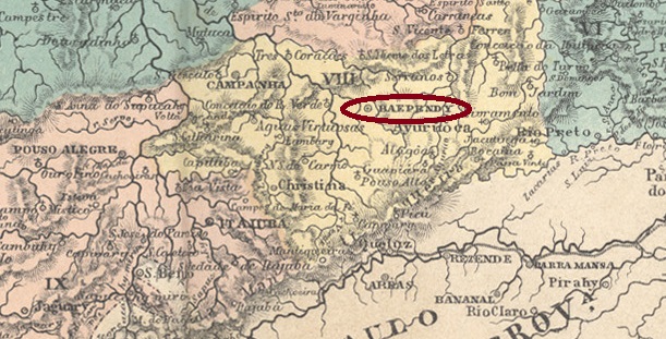
In August 1752, the freguesia called Sta. Maria de Baependi came into being, located at the Vila of Campanha da Princesa on the south bank of the Baependi River, more than 30 km southwest of the provincial capital Ouro Preto. It became a vila in July 1814 and a town in May 1856.
Two dates of origin for the local post office have been found. First in March 1829, as Nova Monteiro writes in Administrações e Agencias Postaes do Brasil Imperio (Brasil Filatelico/RJ, 1934-5; Reprint SPP 1994-1999). Then again in October 1833, as can be read both in the postal report (Relatorio dos Correios) for 1887 and in Paula Sobrinho (História Postal de Minas Gerais, Belo Horizonte, 1997).
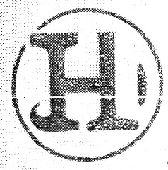
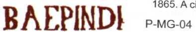
The first postmark is BMG-0170a, which was in use from 1829 and can already be found in the RHM catalogue under P-MG-04:
BMG-0170a (RHM P-MG-04)
Its successor BMG-0170b is very similar and was also presented in the RHM catalogue:
BMG-0170b (RHM P-MG-05) 1835-1837
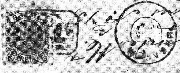
After that there came BMG-0170c, used from 1837 to at least 1877, also occurring in brown, crimson and green-blue and already shown by Paulo Ayres in Catálogo de Carimbos Brasil-Império, (S. Paulo, 1937, 1942) under No. 1216. However, his illustration has some inaccuracies, as can be seen by comparison:
BMG-0170c (P.A. 1216, RHM P-MG-06, recte JLF)
The last postmark in the Empire was BMG-0170d (illustration from the internet): a plain double circle with the inscription BAEPENDY at the top. The dates in the middle go from 1877 to 1895.
Villiers de l’Ile Adam: Carta (…) da Provincia de Minas Gerais, 1849
Im August 1752 entstand die Freguesia namens Sta. Maria de Baependi, die bei der Vila von Campanha da Princesa am Südufer des Flusses Baependi lag, über 30 km südwestlich der Provinzhauptstadt Ouro Preto entfernt. Im Juli 1814 wurde der Ort eine Vila und bereits im Mai 1856 eine Stadt.
Zwei Entstehungstermine fürs örtliche Postamt wurden gefunden. Erstmals im März 1829, wie Nova Monteiro in Administrações e Agencias Postaes do Brasil Imperio (Brasil Filatelico/RJ, 1934-5; Reprint SPP 1994-1999) schreibt. Dann wieder im Oktober 1833, wie sowohl im Postbericht (Relatorio dos Correios) für 1887 als auch bei Paula Sobrinho (História Postal de Minas Gerais, Belo Horizonte, 1997) zu lesen ist.
Der erste Poststempel ist BMG-0170a, der ab 1829 in Gebrauch war und bereits im RHM-Katalog unter P-MG-04 zu finden ist:
BMG-0170a (RHM P-MG-04) 1829
Sein Nachfolger BMG-0170b ist ihm sehr ähnlich und wurde ebenfalls im RHM-Katalog präsentiert:
BMG-0170b (RHM P-MG-05) 1835-1837
Danach kam BMG-0170c, der von 1837 bis mindestens 1877 verwendet wurde, auch in braun, karminrot und grünblau vorkommt und schon von Paulo Ayres in Catálogo de Carimbos Brasil-Império, (S. Paulo, 1937, 1942) unter Nr. 1216 gezeigt wurde. Allerdings hat seine Abbildung einige Ungenauigkeiten, wie man beim Vergleich feststellen kann:
BMG-0170c (P.A. 1216, RHM P-MG-06, recte JLF)
Der letzte Poststempel im Kaiserreich war BMG-0170d (Abb. aus dem Internet): ein schlichter Doppelkreis mit der Inschrift BAEPENDYoben. Die Daten in der Mitte gehen von 1877 bis 1895.
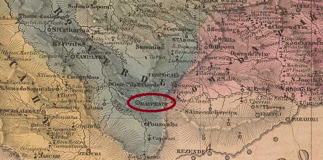
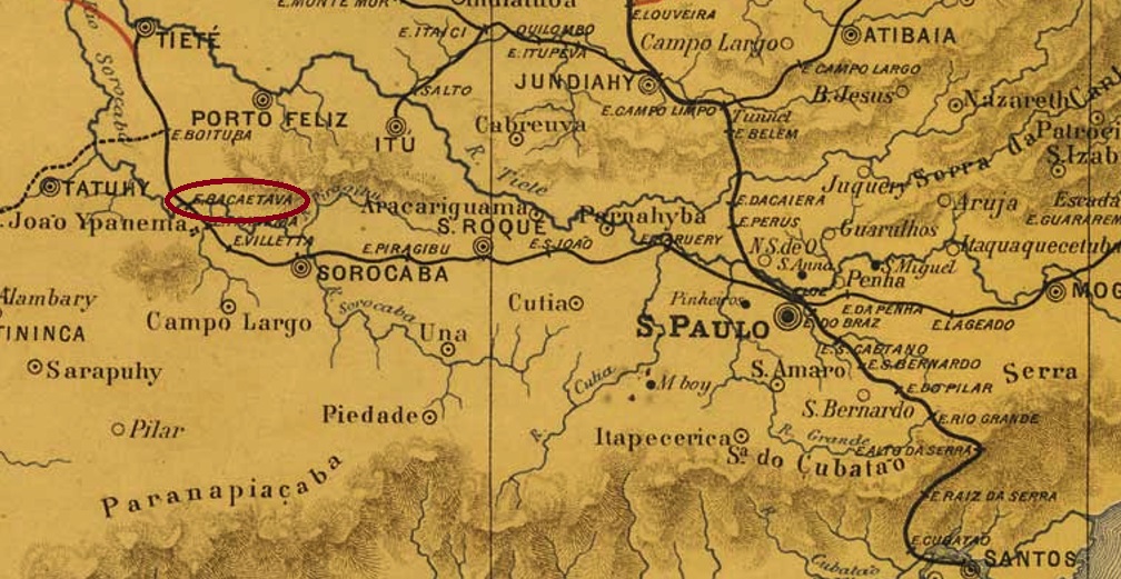
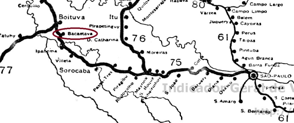
Bacaetava station was inaugurated in August 1880 by the E.F. Sorocabana Railway Company, Main Line, located in the Município of Porto Feliz, 130 km west of the provincial capital São Paulo. The railway line changed hands in 1892 to the Cia. União Sorocabana e Ytuana and from 1905 to 1928 it belonged to the E.F. Sorocabana e Ytuana. Then the station was deactivated, as the new company Sorocabana built a new railway line that relocated the station.
There was a station post office from August 1880 on, as reported by the regional press:
Jornal da Tarde, 01.09.1880
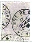
The imperial postmark BSP-0075a (image: F. Piccinini) is a French type:
BSP-0075a (FP) 1880ff-1891Cia. Sorocabana e Ytuana, 1898
Textaktualisierung am 2. Mai 2024
Der Bahnhof Bacaetava wurde im August 1880 durch die E.F. Sorocabana-Bahngesellschaft, Hauptlinie, eingeweiht und lag im Município von Porto Feliz, 130 km westich der Provinzhauptstadt São Paulo entfernt. Die Bahnlinie wechselte 1892 zur Cia. União Sorocabana e Ytuana und von 1905 bis 1928 gehörte sie der E.F. Sorocabana e Ytuana. Dann wurde der Bahnhof deaktiviert, da die neue Gesellschaft Sorocabana eine neue Bahntrasse baute, die den Bahnhof verlegt hat.
Ein Bahnhofspostamt gab es ab August 1880, wie die Regionalpresse meldete:
Jornal da Tarde, 01.09.1880
Der kaiserliche Poststempel BSP-0075a (Abb. Felipe Piccinini) ist ein französischer Typus: