Categories
Carimbologia A-B

Assunguy de Cima, Paraná (APR-0020)

Estado do Paraná, 1896

Text update of January 1st, 2026

Another name: Açungui (1951)

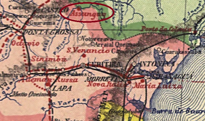
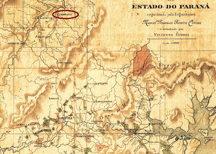
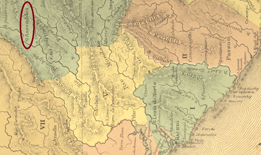
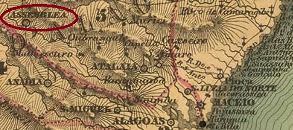
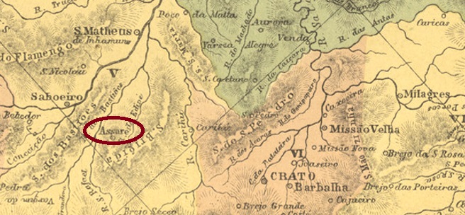
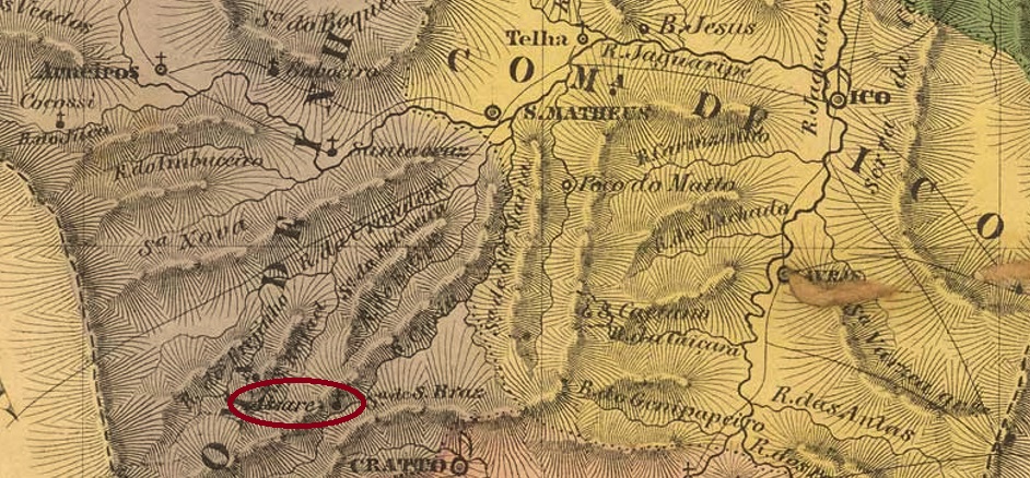
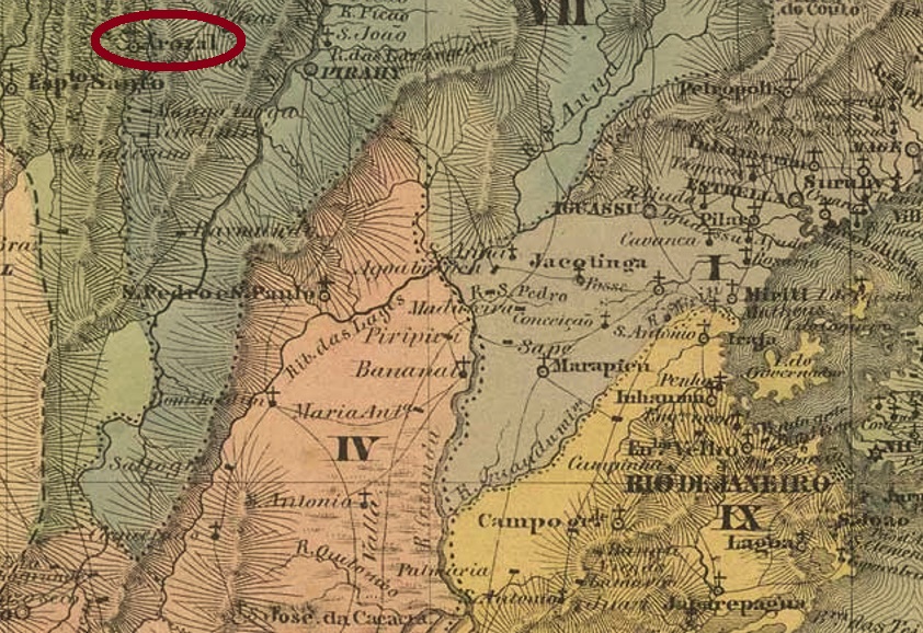
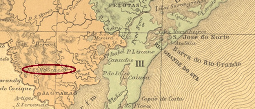
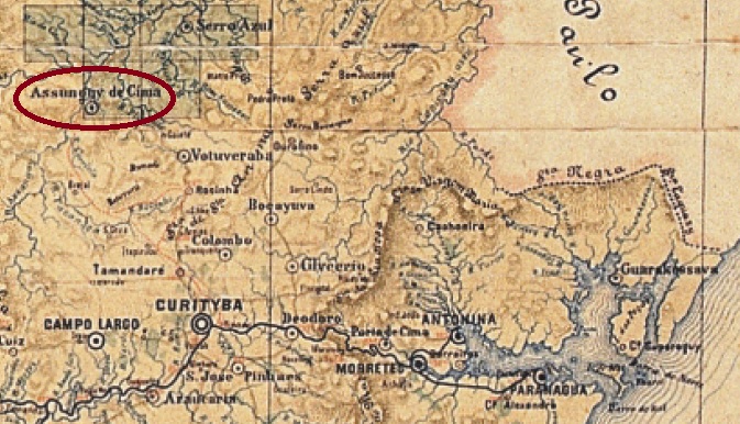
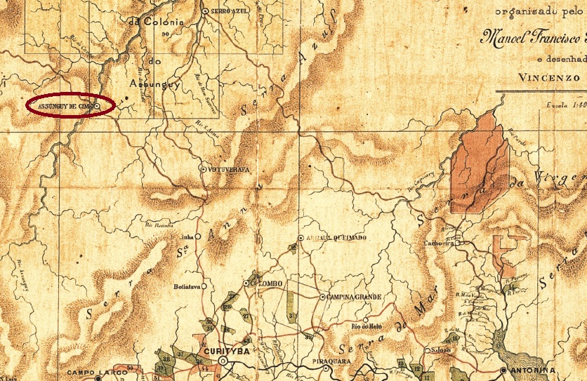
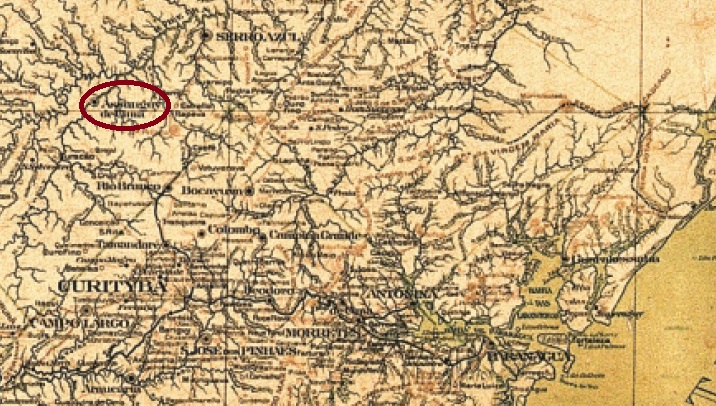
The colony of Assunguy de Cima (= Upper Assunguy) was founded in 1860 in the freguesia of Votuverava on the west bank of the Assunguy River, 70 km north of the provincial capital Curitiba. The place was declared a freguesia of N. Sra. do Amparo de Assunguy de Cima in 1876 and subsequently changed jurisdiction as a district three times: in February 1908 to the Município of Rio Branco, in October 1938 to Cerro Azul and in November 1951 to Rio Branco do Sul. This has remained until today, although the village is now written Açungui.

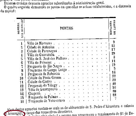
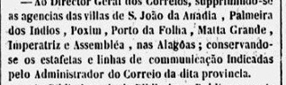
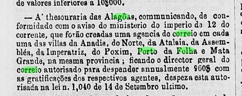
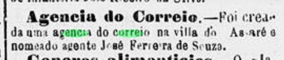
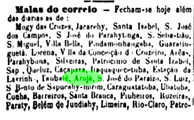
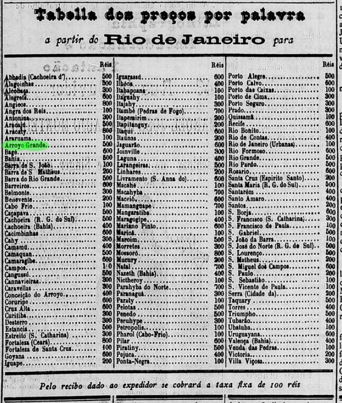
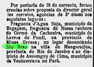
The local post office was created in February 1882, as the Rio press writes:

Gazeta de Noticias/RJ, 19.02.1882

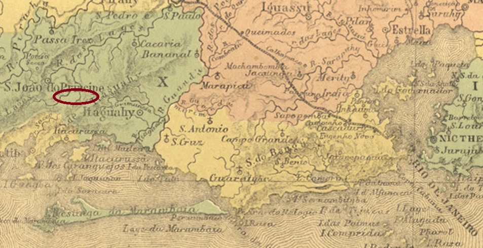
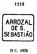
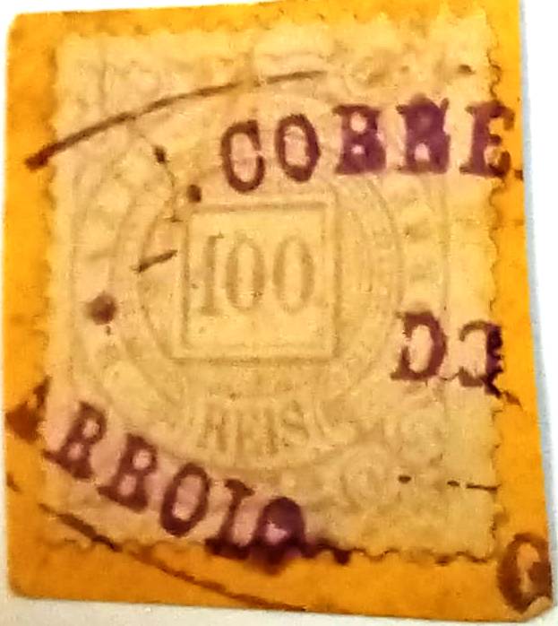
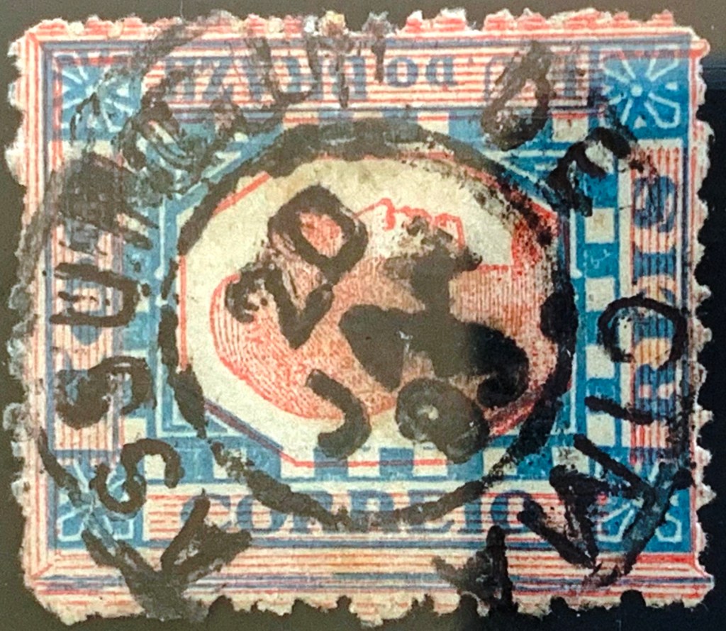
The oldest postmark to date is APR-0020a (Fig. Alexandre Andrade):

APR-0020a (AA) 1893
Estado do Paraná, 1892

Texto atualizado em 13 de janeiro de 2026

Outro nome: Açungui (1951)

A colônia de Assunguy de Cima foi fundada em 1860 na freguesia de Votuverava e estava localizada na margem oeste do rio Assunguy, 70 km ao norte da capital provincial Curitiba. O local foi declarado freguesia de N. Sra. do Amparo de Assunguy de Cima em 1876 e posteriormente mudou de jurisdição como distrito três vezes: em fevereiro de 1908 para o município de Rio Branco, em outubro de 1938 para Cerro Azul e em novembro de 1951 para Rio Branco do Sul. Foi assim que ficou até hoje, embora agora escrito Açungui.

A agência postal local foi criada em fevereiro de 1882, de acordo com a imprensa carioca:

Gazeta de Noticias/RJ, 19.02.1882

O carimbo postal mais antigo até agora é o APR-0020a (fig. Alexandre Andrade):

APR-0020a (AA) 1893
Mappa do Estado do Paraná,1922

Textaktualisierung am 13.01.2026

Anderer Name: Açungui (1951)

Die Kolonie von Assunguy de Cima (= am Oberlauf des Assunguy) wurde 1860 an der Freguesia von Votuverava gegründet und lag am Westufer des Flusses Assunguy, 70 km nördlich der Provinzhauptstadt Curitiba entfernt. Der Ort wurde 1876 zur Freguesia von N. Sra. do Amparo de Assunguy de Cima erklärt und wechselte danach als Distrikt dreimal seine Zuständigkeit: im Februar 1908 zum Município von Rio Branco, im Oktober 1938 zu Cerro Azul und im November 1951 zu Rio Branco do Sul. So ist es bis heute geblieben, wobei sich der Ort inzwischen Açungui schreibt.

Das örtliche Postamt wurde im Februar 1882 ins Leben gerufen, wie die Presse aus Rio schreibt:

Gazeta de Noticias/RJ, 19.02.1882

Der bisher ältester Poststempel ist APR-0020a (Abb. Alexandre Andrade):

APR-0020a (AA) 1893
Categories
Carimbologia A-B

Assunguy, Paraná (APR-0019)

Carta da Republica dos Estados Unidos do Brazil, 1892

Text update on January 16, 2023

Other names: Colonia do Assunguy, Nossa Senhora da Guia do Serro Azul, Cerro Azul (1929)

See also Assunguy (R. Koester: Carimbologia II) and Serro Azul (SPR-0120)

There were two villages called Assunguy in the imperial province of Paraná. This one was established around 1860, when the colony of Assunguy was founded on the east bank of the Ponta Grossa RIver, 90 km north of the provincial capital Curitiba. Assunguy is a Tupi-Guarani language term meaning Blue River. In April 1872, the village rose to become a freguesia in the município of Votuverava, in October 1882, a vila called Serro Azul, and in December 1897, a town. Since 1929, Cerro Azul – as it is now written – has been an independent município.

According to the Imperial Mail Register (Tabella das Agencias do Correio do Império, Rio de Janeiro, 1885), there has been a post office there since 1875. However, the Report of the President of the Province of February 1868 reveals that previously there was already a post office in that colony, managed by its director:

Report of the President of the Province of Paraná, February 1868 (p. 53)

The only postmark of the 19th century so far is APR-0019b (image: Mário Celso Orsi Jr.): a circle with the inscriptions ASSUNGUY. The only specimen found is from 1885 and does not show details of the lower arch. Later cancels from 1889 already show the name Serro Azul (see SPR-0120).

Estado do Paraná, 1892

Textaktualisierung am 16. Januar 2023

Andere Namen: Colonia do Assunguy, Nossa Senhora da Guia do Serro Azul, Cerro Azul (1929)

Siehe auch Assunguy (R. Koester: Carimbologia II) und Serro Azul (SPR-0120)

Es gab zwei Ortschaften in der kaiserlichen Provinz Paraná, die Assunguy hießen. Diese entstand um 1860, als die Kolonie Assunguy am Ostufer des Flusses Ponta Grossa gegründet wurde, 90 km nördlich der Provinzhauptstadt Curitiba entfernt. Assunguy ist ein Begriff der Tupi-Guarani Sprache und bedeutet Blauer Fluss. Im April 1872 stieg der Ort zur Freguesia im Município von Votuverava, im Oktober 1882 zur Vila namens Serro Azul und im Dezember 1897 zur Stadt. Seit 1929 ist Cerro Azul – wie man jetzt schreibt – ein eigenständiger Município.

Laut Verzeichnis der kaiserlichen Postämter (Tabella das Agencias do Correio do Imperio, Rio de Janeiro, 1885) gibt es dort ein Postamt seit 1875.

Aus dem Bericht des Provinzpräsidenten vom Februar 1868 geht jedoch hervor, dass es in dieser Kolonie bereits ein Postamt gab, das von seinem Direktor geleitet wurde:

Bericht des Präsidenten der Provinz Paraná, Februar 1868 (S. 53)

Der bisher einzige Stempel des 19. Jahrhunderts ist APR-0019b (Bild: Mário Celso Orsi Jr.): ein Kreis mit der Inschrift ASSUNGUY. Das einzige gefundene Exemplar stammt aus dem Jahr 1885 und zeigt keine Details des unteren Bogens. Spätere Stempel von 1889 zeigen bereits den Namen Serro Azul (siehe SPR-0120).

Categories
Carimbologia A-B

Assú, Rio Grande do Norte (ARN-0030)

Atlas do Imperio do Brasil, 1868

Other names: Arraial de N. Sra. dos Prazeres, Vila Nova da Princesa

This village was founded in April 1696 under the name Arraial de N. Sa. dos Prazeres and was located on the west bank of the river Piranhas, also called Açu (large, in Tupi), 210 km west of the later provincial capital Natal. In August 1788, the place rose to vila status, with the name Villa Nova da Princesa, and since October 1845 has been the town of Assú, now spelled Açu.

As Nova Monteiro writes in Administrações e Agencias Postaes do Brasil Imperio (Brasil Filatelico/RJ, 1934-5; Reprint SPP 1994-1999), there was a post office there from April 1818, which means there could be a local postmark under Princesa. So far, however, only one 19th century postmark has been found: ARN-0030c (Coll. Roberto Assef Jr.) is a double circle with the inscription ASSÚ. It also occurs in purple and has internal dates from 1891 to at least 1894.

Villiers de l’Ile Adam: Carta (…) das Provincias do Rio Grande do Norte e Parahiba, 1848

Andere Namen: Arraial de N. Sra. dos Prazeres, Vila Nova da Princesa

Diese Ortschaft wurde im April 1696 unter dem Namen Arraial de N. Sa. dos Prazeres gegründet und lag am Westufer des Flusses Piranhas, der auch Açu (groß, in Tupi) genannt wird, 210 km westlich der späteren Provinzhauptstadt Natal entfernt. Im August 1788 stieg der Ort zur Vila-Status auf, mit Namen Villa Nova da Princesa, und ist seit Oktober 1845 die Stadt Assú, heute Açu geschrieben.

Wie Nova Monteiro in Administrações e Agencias Postaes do Brasil Imperio (Brasil Filatelico/RJ, 1934-5; Reprint SPP 1994-1999) schreibt, gab es dort ein Postamt seit April 1818. Das bedeutet, es könnte ein lokaler Poststempel unter Princesa existieren. Bisher wurde aber nur ein Stempel im 19. Jahrhundert gefunden: ARN-0030c (Samml. Roberto Assef Jr.) ist ein Doppelkreis mit der Inschrift ASSÚ. Er kommt auch in lila vor und hat innere Daten von 1891 bis mindestens 1894.

Categories
Carimbologia A-B

Assemblea, Alagoas (AAL-0020)

Atlas do Imperio do Brasil, 1868

Other names: Riacho do Meio, Viçosa (1890-1943, 1949).

This settlement originated around 1809 under the name of Riacho do Meio (Middle Brook) and belonged at that time to the Villa of Atalaia, 90 km northwest of the later provincial capital Maceió. The place was declared a vila in October 1831, three and a half years before it became a freguesia. In November 1890 – in the early Republic – the place name changed to Villa Viçosa, which was declared a town in May 1892. Between December 1943 and September 1949, the old name Assembléia returned, before the Município was finally called Viçosa.

Two periods of operation were found for the local post office. The first began in 1845, as shown in the Directory of Imperial Post Offices (Tabella das Agencias do Correio do Imperio, Rio de Janeiro, 1885), and ended in October 1847, as announced by the official press in Rio:

Gazeta Official/RJ, 13/10/1847

In November 1859, the order to reopen the post office came out:

Boletim do Ministerio do Imperio, 14.11.1859

So far only one imperial postmark from this locality has been seen, unfortunately not the oldest. AAL-0020b (Coll. Karlheinz Wittig) is a plain double circle with the inscription ASSEMBLEA at the top. The dates in the middle go from 1880 to 1890.

Villiers de l’Ile Adam: Carta (…) das Provincias de Pernambuco, Alagoas e Sergipe, 1848

Andere Namen: Riacho do Meio, Viçosa (1890-1943, 1949)

Diese Siedlung entstand um 1809 unter dem Namen Riacho do Meio (Mittelbach) und gehörte damals der Villa von Atalaia, 90 km nordwestlich der späteren Provinzhauptstadt Maceió entfernt. Der Ort wurde im Oktober 1831 zur Vila erklärt und damit dreieinhalb Jahre bevor er eine Freguesia wurde. Im November 1890 – also in der frühen Republik – wechselte der Ortsname zu Villa Viçosa, die im Mai 1892 zur Stadt erklärt wurde. Zwischen Dezember 1943 und September 1949 kehrte der alte Name Assembléia zurück, bevor der Município endgültig Viçosa hieß.

Es wurden zwei Betriebsperioden fürs örtliche Postamt gefunden. Die erste begann 1845, wie aus demVerzeichnis der kaiserlichen Postämter (Tabella das Agencias do Correio do Imperio, Rio de Janeiro, 1885) hervorgeht, und endete im Oktober 1847, wie die Amtspresse in Rio angekündigt hat:

Gazeta Official/RJ, 13.10.1847

Im November 1859 kam die Anordnung zur Wiedereröffnung des Postamtes heraus:

Boletim do Ministerio do Imperio, 14.11.1859

Bisher war nur ein kaiserlicher Poststempel aus dieser Ortschaft zu sehen, leider nicht der älteste. AAL-0020b (Samml. Karlheinz Wittig) ist ein schlichter Doppelkreis mit der Inschrift ASSEMBLEA oben. Die Daten in der Mitte gehen von 1880 bis 1890.

Categories
Carimbologia A-B

Assaré, Ceará (ACE-0035)

Atlas do Imperio do Brasil, 1868

The Freguesia of N. Sra. das Dores de Assaré was founded in December 1850 at the Vila of Saboeiro, 480 km south of the provincial capital Fortaleza. In July 1865, the place was declared a vila in its own município.

The local post office was established in January 1877, according to the regional press:

Cearense, 25.01.1877

No imperial postmark from this locality has yet appeared.

Villiers de l’Ile Adam: Carta (…) da Provincia do Ceara, 1849

Die Freguesia von N. Sra. das Dores de Assaré wurde im Dezember 1850 bei der Vila von Saboeiro gegründet und lag 480 km südlich der Provinzhauptstadt Fortaleza. Im Juli 1865 wurde der Ort zur Vila im eigenen Município erklärt.

Das örtliche Postamt wurde im Januar 1877 ins Leben gerufen, wie aus der Regionalpresse hervorgeht:

Cearense, 25.01.1877

Bisher ist kein kaiserlicher Poststempel aus dieser Ortschaft aufgetaucht.

Categories
Carimbologia A-B

Arujá, São Paulo (ASP-0060)

Atlas do Imperio do Brasil, 1868

The Freguesia of Senhor Bom Jesus de Arujá originated in June 1852 in the Vila of Mogy das Cruzes and was located 40 km northeast of the provincial capital of São Paulo. The village only became a district of Santa Isabel in November 1938 and has been an independent município since February 1959. The name clearly has its origins in the Tupi language, but its meaning is not clear: according to some sources it means owner of the sky. Others say it means home of the frogs

Also, still unclear is when the local post office was established. It is not even listed in the Imperial Postal Guide (Guia Postal do Imperio, 1880). Yet the regional press regularly reported postal traffic via Arujá from August 1875 onwards:

Correio Paulistano, 29.08.1875

The imperial postmark is the French type ASP-0060a (coll. Mario Nacimovic): a small double circle with the inscription ARUJA above and the small star between brackets below. The dates in the middle so far go from 1880 to 1886.

J.M. Ribeiro Lisboa: Provincia de São Paulo, 1884

Die Freguesia von Senhor Bom Jesus de Arujá entstand im Juni 1852 in der Vila von Mogy das Cruzes und lag 40 km nordöstlich der Provinzhauptstadt São Paulo entfernt. Der Ort wurde erst im November 1938 zu einem Distrikt von Santa Isabel und ist seit Februar 1959 ein eigenständiger Município. Der Name hat eindeutig seinen Ursprung in der Tupi-Sprache, aber seine Bedeutung ist nicht klar: nach einigen Quellen heißt er Besitzer des Himmels. Andere sagen, es bedeutet Heimat der Frösche

Ebenfalls noch unklar ist, wann das örtliche Postamt entstanden ist. Im Kaiserlichen Postführer (Guia Postal do Imperio, 1880) ist es gar nicht aufgelistet. Dabei wurde in der Regionalpresse ab August 1875 regelmäßig über Postverkehr über Arujá gemeldet:

Correio Paulistano, 29.08.1875

Der kaiserliche Poststempel ist der französische Typus ASP-0060a (Samml. Mario Nacimovic): ein kleiner Doppelkreis mit der Inschrift ARUJA oben und dem kleinen Stern zwischen Klammern unten. Die Daten in der Mitte gehen bisher von 1880 bis 1886.

Categories
Carimbologia A-B

Arrozal (Pirahy), Rio de Janeiro (ARJ-0080)

Atlas do Imperio do Brasil, 1868

Other name: São João Baptista do Arrozal

The parish of S. João Baptista do Arrozal originally belonged to the Vila of S. João do Príncipe but changed to the Vila of Pirahy as a freguesia in April 1839, located 115 km northwest of the capital Rio de Janeiro. Since December 1938, the place has been a district.

The local post office was established as early as December 1832, as Nova Monteiro writes in Administrações e Agencias Postaes do Brasil Imperio (Brasil Filatelico/RJ, 1934-5; Reprint SPP 1994-1999). The first postmark is probably ARJ-0080a, which was in use at least until 1848 and is known to us through the RHM catalogue:

ARJ-0080a (RHM) 1843ff-1848

It was followed by ARJ-0080b, which occurs in two versions. The better known of these is the one by Paulo Ayres (Catálogo de Carimbos Brasil-Império, S. Paulo, 1937, 1942) with the no. 1212. The RHM catalogue shows a variant of it, which seems a bit strange:

ARJ-0080b (P.A. 1212-recte RHM) 1843ff-1866ff

From about 1850 there came ARJ-0080c (coll. Klerman Lopes), with features the seal of the Empire. And towards the end of this period, we have ARJ-0080d (agenciaspostais.com.br): a simple double circle with the inscription ARROZAL on top and internal dates so far between 1885 and 1887.

From Arrozal we also have, thanks to James Dingler and Klerman Lopes (Mute Cancellations of the Brazil Empire / Carimbos Mudos do Brasil Império, Brazil Philatelic Association, Rio de Janeiro, 2000), a mute postmark with no. 915:

BPA 915
Villiers de l’Ile Adam: Carta (…) da Provincia do Rio de Janeiro, 1850

Anderer Name: São João Baptista do Arrozal

Die Pfarrei von S. João Baptista do Arrozal gehörte ursprünglich der Vila von S. João do Príncipe, wechselte aber im April 1839 als Freguesia zur Vila von Pirahy und lag 115 km nordwestlich der Hauptstadt Rio de Janeiro entfernt. Seit Dezember 1938 ist der Ort ein Distrikt.

Das lokale Postamt wurde bereits im Dezember 1832 ins Leben gerufen, wie Nova Monteiro in Administrações e Agencias Postaes do Brasil Imperio (Brasil Filatelico/RJ, 1934-5; Reprint SPP 1994-1999) schreibt. Der erste Poststempel dürfte ARJ-0080a sein, der zumindest bis 1848 in Gebrauch war und uns durch den RHM-Katalog bekannt ist:

ARJ-0080a (RHM) 1843ff-1848

Ihm folgte ARJ-0080b, der in zwei Versionen vorkommt. Die bekanntere davon ist die von Paulo Ayres (Catálogo de Carimbos Brasil-Império, S. Paulo, 1937, 1942) mit der Nr. 1212. Der RHM-Katalog zeigt eine Variante davon, die etwas merkwürdig vorkommt:

ARJ-0080b (P.A. 1212-recte RHM) 1843ff-1866ff

Ab ca. 1850 kam ARJ-0080c (Samml. Klerman Lopes), mit dem Siegel des Kaiserreiches. Und gegen Ende dieser Zeit haben wir ARJ-0080d (agenciaspostais.com.br): ein einfacher Doppelkreis mit der Inschrift ARROZAL oben und inneren Daten bisher zwischen 1885 und 1887.

Aus Arrozal haben wir auch dank James Dingler und Klerman Lopes (Mute Cancellations of the Brazil Empire / Carimbos Mudos do Brasil Império, Brazil Philatelic Association, Rio de Janeiro, 2000) einen stummen Poststempel mit Nr. 915:

BPA 915
Categories
Carimbologia A-B

Arrozal de São Sebastião, Rio de Janeiro (ARJ-0085)

Atlas do Imperio do Brasil, 1868

Another name: Arraial do Principe (1939-1943).

This locality is another one that has literally disappeared from the map. The former settlement of the Vila of S. João Marcos became a district in 1890, changing to the newly created Município of Rio Claro the following year. In 1939 came a new place name: Arrozal do Principe (The Prince’s Rice Fields), which lasted only 4 years. Then the whole place was flooded by the Ribeirão das Lajes reservoir.

The local post office was established in August 1877, but the Rio press mistakenly assigned it to the Municipio of Pirahy. This seems to be confusion with the other place Arrozal (ARJ-0080):

Jornal do Commercio, 24.08.1877

The first postmark is ARJ-0085a, which also exists in blue, and was presented by Paulo Ayres (Catálogo de Carimbos Brasil-Império, S. Paulo, 1937, 1942) under no. 1213:

ARJ-0085a (P.A. 1213) 1877ff

It was followed by ARJ-0085b (Coll. José A. Junges): a double circle with the inscription A. DE S: SEBASTIÃO above and an ornament in lozenge below. It also occurs in blue and has inner dates between 1882 and 1887.

agenciaspostais.com.br

Anderer Name: Arraial do Principe (1939-1943)

Diese Ortschaft ist eine weitere, die buchstäblich aus der Landkarte verschwunden ist. Die ehemalige Siedlung der Vila von S. João Marcos wurde 1890 zu einem Distrikt, der im darauf folgenden Jahr zum neu gegründeten Município von Rio Claro wechselte. Im Jahre 1939 kam ein neuer Ortsname: Arrozal do Principe (Des Prinzen Reisfelder), der nur 4 Jahre andauerte. Dann wurde der ganze Ort durch den Stausee Ribeirão das Lajes überschwemmt.

Das örtliche Postamt entstand im August 1877, dabei wurde es durch die Presse aus Rio irrtümlicherweise dem Municipio von Pirahy zugeordnet. Hier liegt offenbar eine Verwechslung mit dem anderen Ort Arrozal (ARJ-0080) vor:

Jornal do Commercio, 24.08.1877

Der erste Poststempel ist ARJ-0085a, den es auch in Blau gibt, und der durch Paulo Ayres (Catálogo de Carimbos Brasil-Império, S. Paulo, 1937, 1942) unter Nr. 1213 vorgestellt wurde:

ARJ-0085a (P.A. 1213) 1877ff

Ihm folgte ARJ-0085b (Samml. José A. Junges): ein Doppelkreis mit der Inschrift A. DE S: SEBASTIÃO oben und einem Ornament in Raute unten. Er kommt auch in blau vor und hat innere Daten zwischen 1882 und 1887.

Categories
Carimbologia A-B

Arroio Grande, Rio Grande do Sul (ARS-0015)

Villiers de l’Ile Adam: Carta (…) da Provincia de São Pedro do Sul, 1847

Text update on January 10, 2023

Another name: Federação

The Freguesia of N. Sra. da Graça do Arroio Grande was founded in January 1812 and was on the north bank of the Arroio Grande River at the Vila of Jaguarão, 340 km southwest of the future provincial capital Porto Alegre. The place was declared a vila in March 1873 and a town called Federação in December 1890. This name apparently did not go down well, and as early as July 1891 the old place name Arroio Grande definitively returned.

It has not yet been possible to determine the exact date of origin of the local post office, but it must have been between 1880 and 1882. The agency was not yet listed in the postal guide (Guia Postal do Imperio) of 1880, but was already offering telegraph services in June 1882:

Diario do Brazil/RJ, 04.06.1882

The first postmark is ARS-0015a and was already presented by R. Koester in Carimbologia II:

ARS-0015a (RK) 1884ff-1889

ARS-0015b (Coll. Fuad Ferreira Fo.) seems to be older, but it appeared in lilac on an 1888 issue:

ARS-0015b (FF)
Atlas do Imperio do Brasil, 1868

Textaktualisierung am 10. Januar 2023

Anderer Name: Federação

Die Freguesia von N. Sra. da Graça do Arroio Grande wurde im Januar 1812 gegründet und lag am Nordufer des Flusses Arroio Grande bei der Vila von Jaguarão, 340 km südwestlich der späteren Provinzhauptstadt Porto Alegre entfernt. Der Ort wurde im März 1873 zur Vila und im Dezember 1890 zur Stadt Federação erklärt. Dieser Name kam offenbar nicht gut an, der schon im Juli 1891 kehrte der alte Ortsname Arroio Grande endgültig zurück.

Es war bisher nicht möglich, den genauen Enstehungszeitpunkt fürs örtliche Postamt zu ermitteln, muss aber zwischen 1880 und 1882 gewesen sein. Denn die Agentur war noch nicht im Postführer (Guia Postal do Imperio) von 1880 aufgelistet, hatte aber bereits im Juni 1882 Telegraphie-Dienste anzubieten:

Diario do Brazil/RJ, 04.06.1882

Der erste Poststempel ist ARS-0015a und wurde bereits durch R. Koester in Carimbologia II vorgestellt:

ARS-0015a (RK) 1884ff-1889

ARS-0015b (Samml. Fuad Ferreira Fo.) scheint älter zu sein, erschien aber in Lila auf einer Ausgabe von 1888:

ARS-0015b (FF)
Categories
Carimbologia A-B

Arraias, Goiás (AGO-0015)

Atlas do Imperio do Brasil, 1868

Other names: Arraial da Chapada dos Negros, Arrayas

This place was originally called Arraial de N. Sra. dos Remédios de Arraias and was located on the east bank of the Arraias River, 700 km northeast of the former provincial capital Goyaz (now Goiás Velho). Although it was declared a vila in April 1833, it was downgraded again as a district, first to Cavalcante, then to the município of Monte Alegre in July 1852. In July 1861, it was promoted again to Vila, and in August 1914 to a town, which has been in the state of Tocantins since 1988. Arraia is the generic name of various freshwater rays (Potamotrygon sp.) in Brazil:

Potamotrygon sp. (Wikimedia commons)

As Nova Monteiro writes in Administrações e Agencias Postaes do Brasil Imperio (Brasil Filatelico/RJ, 1934-5; Reprint SPP 1994-1999), there was a post office there from January 1851. So far, no imperial postmark of Arraias has been seen.

Provincia de Goyaz, 1875

Andere Namen: Arraial da Chapada dos Negros, Arrayas

Dieser Ort hieß ursprünglich Arraial de N. Sra. dos Remédios de Arraias und lag am Ostufer des Flusses Arraias, 700 km nordöstlich der ehemaligen Provinzhauptstadt Goyaz (heute: Goiás Velho) entfernt. Er wurde zwar im April 1833 zur Vila ernannt, wurde aber wieder als Distrikt herabgestuft, zunächst zu Cavalcante, dann im Juli 1852 zum Município von Monte Alegre. Im Juli 1861 erfolgte der Wiederaufstieg zu Vila, und im August 1914 zu einer Stadt, die seit 1988 im Bundesstaat Tocantins liegt. Arraia ist der generische Name von diversen Süßwasserrochen (Potamotrygon sp.) in Brasilien:

Potamotrygon sp. (Wikimedia commons)

Wie Nova Monteiro in Administrações e Agencias Postaes do Brasil Imperio (Brasil Filatelico/RJ, 1934-5; Reprint SPP 1994-1999) schreibt, gab es ein Postamt dort seit Januar 1851. Bisher war kein kaiserlicher Poststempel von Arraias zu sehen.