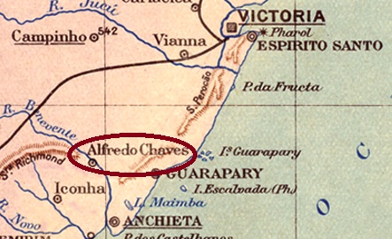
Alfredo Chaves was a colony of European immigrants – mostly Italians – who settled on the west bank of the Benevente River, over 80 km southwest of the provincial capital Vitória, from 1877. The place grew rapidly, receiving the status of Município in January 1891 and becoming a town in May 1924. The name commemorates the engineer and politician Alfredo Rodrigues Fernandes Chaves (1844-1894), who strongly promoted Italian immigration. Another colony in Rio Grande do Sul was also named after him, the present-day city of Veranópolis.
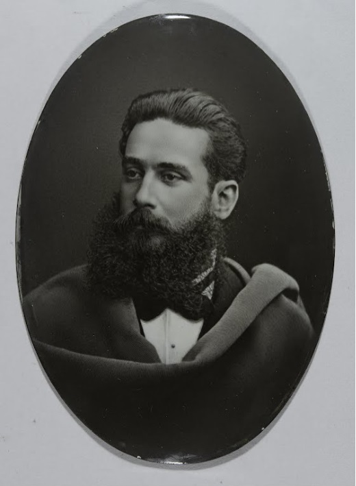
Photo: José Ferreira Guimarães, 1886
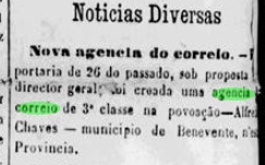
The local post office was created by an order in October 1882, as reported in the regional press:
A Provincia do Espirito Santo, 05.11.1882
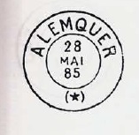
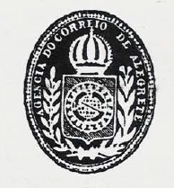
The imperial postmark is AES-0010a (image from the internet): a double circle with the inscription CORRO DE ALFREDO CHAVES at the top and an ornament in the shape of a Maltese Cross at the bottom. The dates in the middle have so far been found for the period 1886-1888.
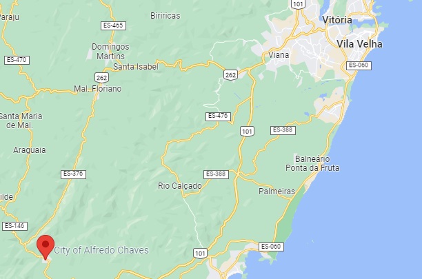
Google Maps
Alfredo Chaves war ab 1877 eine Kolonie von europäischen Einwanderern – meistens Italiener – die sich am Westufer des Flusses Benevente niedergelassen haben, über 80 km südwestlich der Provinzhauptstadt Vitória entfernt. Der Ort wuchs schnell, erhielt im Januar 1891 den Status eines Município und wurde im Mai 1924 eine Stadt. Der Name soll an den Ingenieur und Politiker Alfredo Rodrigues Fernandes Chaves (1844-1894) erinnern, der sich stark für die italienische Einwanderung machte. Nach ihm wurde auch eine weitere Kolonie in Rio Grande do Sul genannt, die heutige Stadt Veranópolis.
Foto: José Ferreira Guimarães, 1886
Das örtliche Postamt entstand durch eine Anordnung vom Oktober 1882, wie die Regionalpresse berichtet:
A Provincia do Espirito Santo, 05.11.1882
Der kaiserliche Poststempel ist AES-0010a (Abb. aus dem Internet): ein Doppelkreis mit der Inschrift CORRO DE ALFREDO CHAVES oben und einem Ornament in Form eines Malteser Kreuzes unten. Die Daten in der Mitte wurden bisher für den Zeitraum 1886-1888 gefunden.
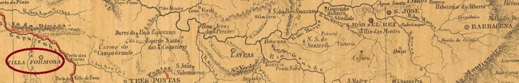
See also Alfenas and Formosa de Alfenas (R. Koester: Carimbologia I and XIX)
The freguesia of São José de Alfenas was established in July 1832 in the município of Caldas and was situated between the São Tomé and Sapucaí rivers, about 390 km southwest of the provincial capital Ouro Preto. In October 1860, it was promoted to Villa Formosa de Alfenas, and exactly nine years later it became a town whose name was shortened to Alfenas in September 1871. Reinhard Koester (Carimbologia XIX) states that this name change was to avoid confusion with the older Villa Formosa (da Imperatriz) in Goiás.
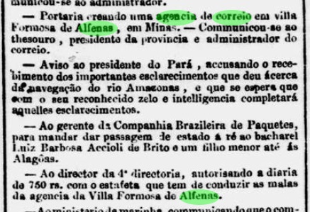
Three dates have been established for the birth of the post office from 1862. Nova Monteiro, in Administrações e Agencias Postaes do Brasil Imperio (Brasil Filatelico/RJ, 1934-5; Reprint SPP 1994-1999) writes the month of March for it, while Paula Sobrinho (História Postal de Minas Gerais, Belo Horizonte, 1997) and Koester (op.cit.) prefer June. The third date is in April 1862 as reported by the Rio press:
Jornal do Commercio/RJ, 25.04.1862, exped. 09.04.
Consequently, Nova Monteiro’s indication could be a transcription error, whereas the date mentioned by Paula Sobrinho and Koester would be the start of operation of the agency. So far, no postmark with Villa Formosa (or de Alfenas) has appeared. Koester (op.cit.) lists AMG-0065b as the oldest postmark with Alfenas: a double circle with the inscription ALFENAS at the top, with internal dates between 1880 and 1884. Its successor AMG-0065c (image from the internet) is very similar, but has an ornament in lozenge at the bottom, formed by four small lozenges. The dates in the centre so far go from 1888 to 1894.
Provincia de Minas Geraes, 1873
Siehe auch Alfenas und Formosa de Alfenas (R. Koester: Carimbologia I und XIX)
Die Freguesia von São José de Alfenas wurde im Juli 1832 im Município von Caldas errichtet und lag zwischen den Flüssen São Tomé und Sapucaí, ca. 390 km südwestlich der Provinzhauptstadt Ouro Preto entfernt. Im Oktober 1860 erfolgte der Aufstieg zur Villa Formosa de Alfenas, und genau neun Jahre später wurde daraus eine Stadt, deren Name im September 1871 zu Alfenas verkürzt wurde. Reinhard Koester (Carimbologia XIX) meint, diese Namensänderung sollte Verwechslungen mit der älteren Villa Formosa (da Imperatriz) in Goiás vermeiden.
Aus dem Jahr 1862 wurden drei Daten für die Entstehung des Postamtes ermittelt. Nova Monteiro schreibt dafür im Administrações e Agencias Postaes do Brasil Imperio (Brasil Filatelico/RJ, 1934-5; Reprint SPP 1994-1999) den Monat März, während Paula Sobrinho (História Postal de Minas Gerais, Belo Horizonte, 1997) und Koester (op.cit.) den Juni bevorzugen. Der dritte Zeitpunkt liegt im April 1862 und wurde in der Presse aus Rio bekannt gemacht:
Jornal do Commercio/RJ, 25.04.1862, exped. 09.04.
Folglich könnte Nova Monteiros Angabe ein Abschreibfehler sein, während das durch Paula Sobrinho und Koester erwähnte Datum den Betriebsbeginn der Agentur wäre. Bisher ist kein Poststempel mit Villa Formosa (bzw. de Alfenas) erschienen. Koester (op.cit.) listet AMG-0065b als ältesten Poststempel mit Alfenas: ein Doppelkreis mit der Inschrift ALFENAS oben, mit inneren Daten zwischen 1880 und 1884. Sein Nachfolger AMG-0065c (Abb. aus dem Internet) ist sehr ähnlich, hat aber unten ein Ornament in Raute, das aus vier kleinen Rauten gebildet wird. Die Daten in der Mitte gehen bisher von 1888 bis 1894.
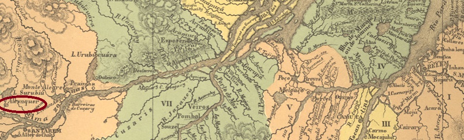
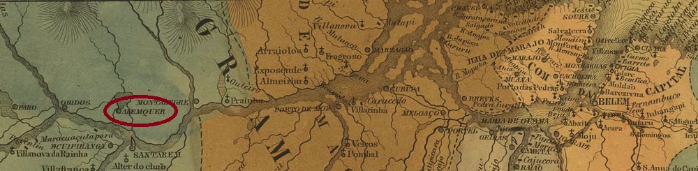
The former settlement called Surubiú (crocodile’s head, in the Indian language Tupi) was founded in June 1729 on the north bank of the Amazon, 700 km as the crow flies west of the later provincial capital Belém do Pará. The place is said to have been elevated to the status of a vila as early as 1758. In May 1833, it was downgraded as a district of Santarém, only to rise again as a vila in June 1848. Since June 1881, Alenquer (as it is written today) has been a town.
Two dates of origin for the local post office have been found. Firstly in 1877, as stated in the Directory of Imperial Post Offices (Tabella das Agencias do Correio do Imperio, Rio de Janeiro, 1885). Then R. Koester writes in Carimbologia I a date of January 1881. This is probably a mistake, because according to the provincial president’s report, the agency had already been in operation for 3 years at that time:
Relatorio do Presidente da Provincia, February 1881
Two 19th century postmarks are also known. APA-0015a will be the oldest of these, according to the illustration it could also be a French type, as shown in Paulo Ayres (Catálogo de Carimbos Brasil-Império, S. Paulo, 1937, 1942) on p. 120:
APA-0015a (P.A. p/S. 120) 1885
It was followed by APA-0015b (image from the internet): a double circle with the inscriptions ALENQUER above and (PARÁ) below. The only specimen so far bears a date from 1899 in the centre.
Villiers de l’Ile Adam: Carta (…) das Provincias de Grão Pará e Alto Amazonas, 1850
Anderer Name: Surubiú
Die ehemalige Siedlung namens Surubiú (Krokodilkopf, in der Indianersprache Tupi) entstand im Juni 1729 am Nordufer des Amazonas, 700 km Luftlinie westlich der späteren Provinzhauptstadt Belém do Pará entfernt. Der Ort soll bereits 1758 zur Vila erhoben worden sein. Im Mai 1833 wurde er als Distrikt von Santarém herabgestuft, um im Juni 1848 wieder als Vila aufzusteigen. Seit Juni 1881 ist Alenquer (wie es heute geschrieben wird) eine Stadt.
Zwei Entstehungsdaten fürs örtliche Postamt wurden gefunden. Erstmals 1877, wie im Verzeichnis der kaiserlichen Postämter (Tabella das Agencias do Correio do Imperio, Rio de Janeiro, 1885) zu lesen ist. Dann schreibt R. Koester in Carimbologia I ein Datum vom Januar 1881. Das dürfte ein Fehler sein, denn laut Bericht des Provinzpräsidenten war die Agentur zu diesem Zeitpunkt bereits 3 Jahre in Betrieb:
Relatorio do Presidente da Provincia, Februar 1881
Zwei Poststempel für das 19. Jahrhundert sind auch bekannt. APA-0015a wird der älteste davon sein, nach der Abbildung könnte es auch ein Französischer Typus sein, wie in Paulo Ayres (Catálogo de Carimbos Brasil-Império, S. Paulo, 1937, 1942) auf S. 120 zu sehen ist:
APA-0015a (P.A. p/S. 120) 1885
Ihm folgte APA-0015b (Abb. aus dem Internet): ein Doppelkreis mit den Inschriften ALENQUER oben und (PARÁ) unten. Das bisher einzige Exemplar trägt ein Datum aus 1899 in der Mitte.
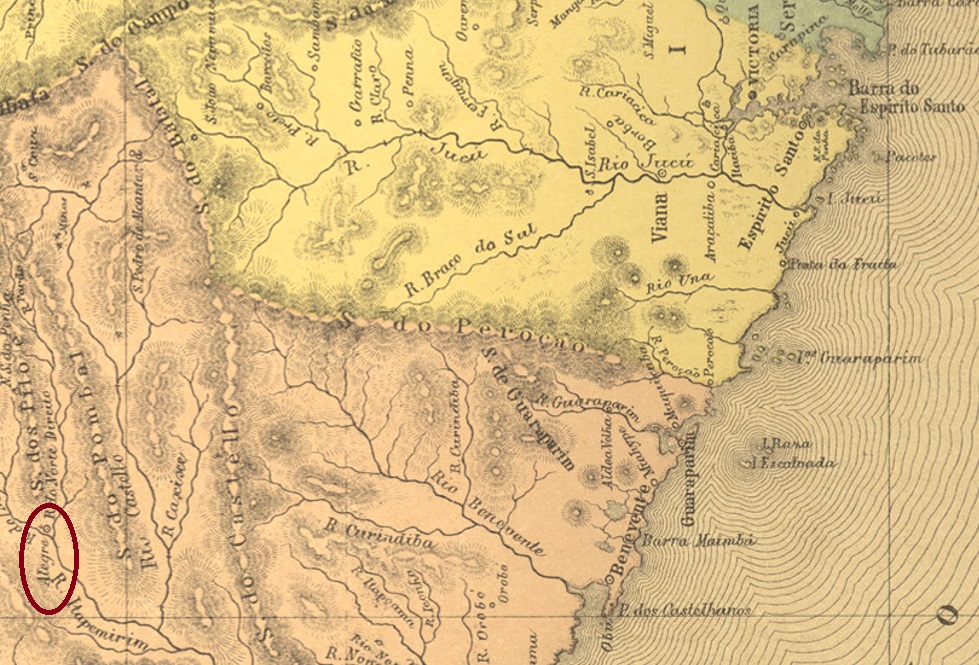
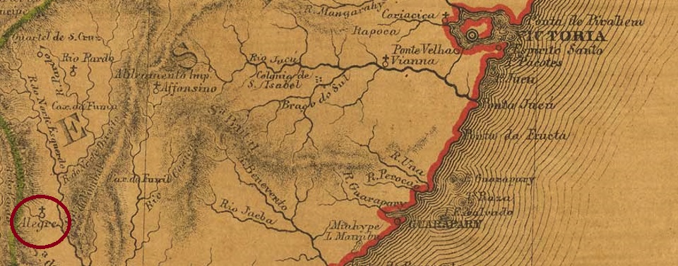
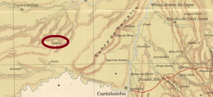
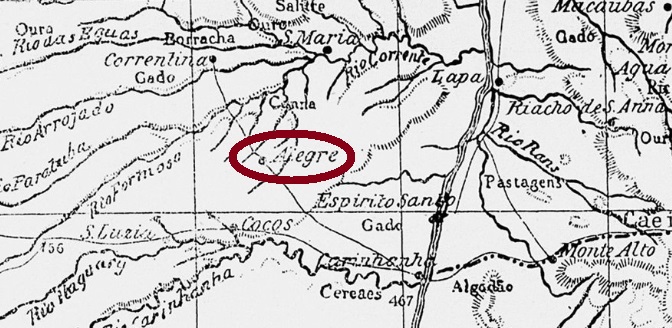
The Freguesia of N. Sra. da Conceição do Alegre was founded in July 1858 in the Município of Cachoeiro do Itapemirim and was located on the river Alegre, a tributary of the Itapemirim, 180 km southwest of the state capital Vitória. The place rose to the Vila of N. Sra. da Penha do Alegre in April 1884.
As Paulo Novaes writes in agenciaspostais.com.br, the local post office was created in November 1875. This is confirmed by the Directory of Imperial Post Offices (Tabella das Agencias do Correio do Imperio, Rio de Janeiro, 1885). The oldest postmark is AES-0005a (image: Filatélica Brasília), found on a D. Pedro issue from 1876:
AES-0005a (Fil. Brasilia) 1876ff
It was followed by AES-0005b (image from the internet): a double circle with the inscription ALEGRE above and an ornament in lozenge below. Dates in the centre come from the period 1887-1893.
Provincia do Espirito Santo, 1873
Die Freguesia von N. Sra. da Conceição do Alegre wurde im Juli 1858 im Município von Cachoeiro do Itapemirim gegründet und lag am Fluss Alegre, einem Zufluss des Itapemirim, 180 km südwestlich der Landeshauptstadt Vitória entfernt. Der Ort stieg im April 1884 zur Vila von N. Sra. da Penha do Alegre auf.
Wie Paulo Novaes in agenciaspostais.com.br schreibt, wurde das örtliche Postamt im November 1875 ins Leben gerufen. Das bestätigt das Verzeichnis der kaiserlichen Postämter (Tabella das Agencias do Correio do Imperio, Rio de Janeiro, 1885). Der älteste Poststempel ist AES-0005a (Abb. Filatélica Brasília), gefunden auf einer D.-Pedro-Ausgabe von 1876:
AES-0005a (Fil. Brasilia) 1876ff
Ihm folgte AES-0005b (Abb. aus dem Internet): ein Doppelkreis mit der Inschrift ALEGRE oben und einem Ornament in Raute unten. Die Daten in der Mitte entstammen dem Zeitraum 1887-1893.
Villiers de l’Ile Adam: Carta (…) da Provincia de São Pedro do Sul, 1847
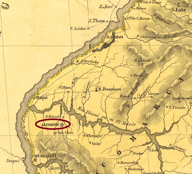
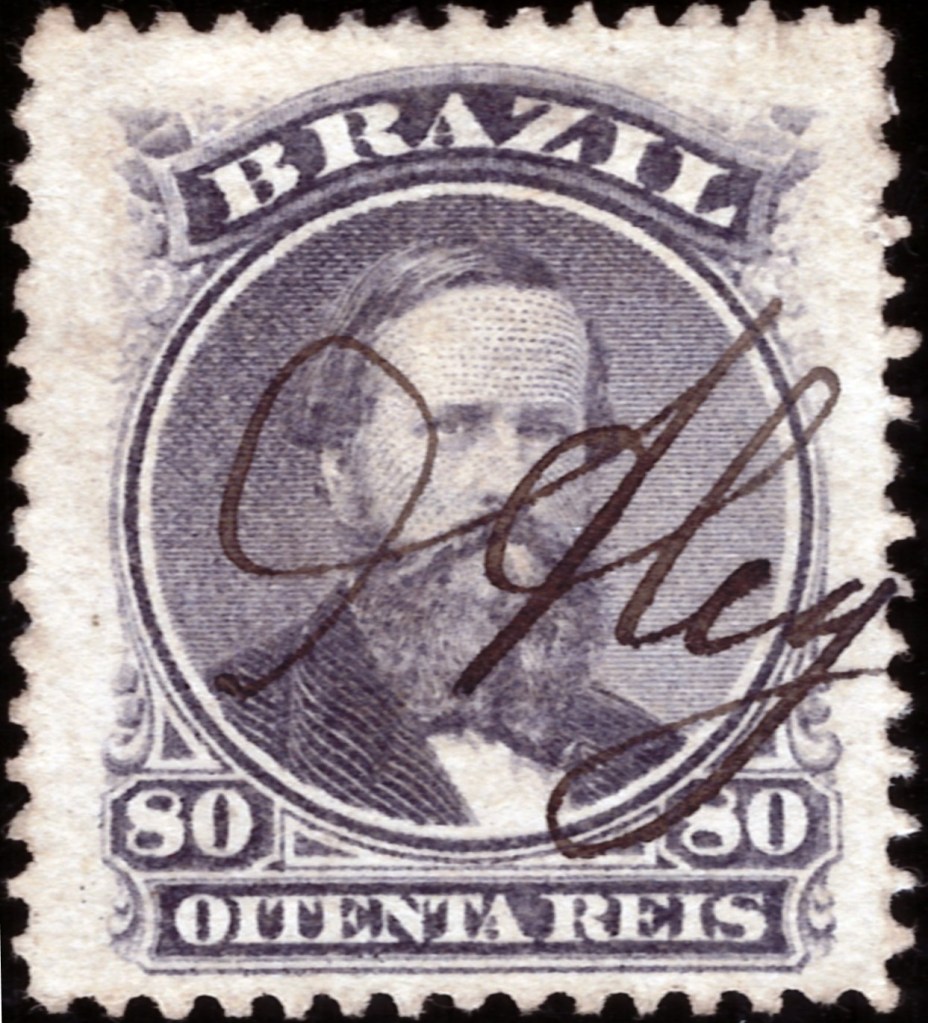
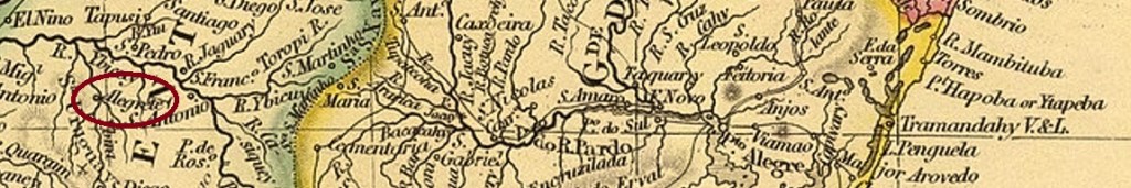
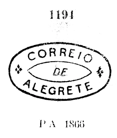
Around 1812, the settlement called Capela Queimada (Burnt Chapel) is said to have been established, located on the left bank of the river Ibirapuitã, 500 km west of the later provincial capital of Porto Alegre. In January 1817, it became the chapel of N. Sra. da Conceição Aparecida de Alegrete, which belonged to the Vila of São Borja. Alegrete has been a vila since October 1831 and a town since January 1857.
The local post office was established twice. First in October 1831, as Nova Monteiro writes in Administrações e Agencias Postaes do Brasil Imperio (Brasil Filatelico/RJ, 1934-5; Reprint SPP 1994-1999). Then again in 1848, after the end of the Farroupilha Revolution (1835-1845). All the postmarks known so far are from the second period of operation. ARS-0005b was used from about 1866 until after 1876 and was already made known by Paulo Ayres in Catálogo de Carimbos Brasil-Império (S. Paulo, 1937, 1942) under no. 1194:
ARS-0005b (P.A. 1194)
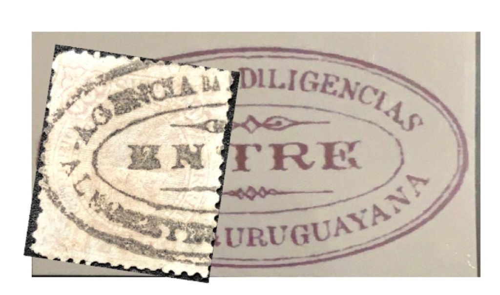
In the period after that came at least three Diligencia cancels, which have already been presented:
Between ca. 1877 and 1888 we have the French type ARS-0005c (image from the internet): a double circle with the inscription ALEGRETE above and the star between brackets below. Around this time ARS-0005d must also have been used, which we know from P. Ayres (op. cit. p.145):
ARS-0005d (P.A. p. 145)
At the end of the imperial period also came ARS-0005e (image from the internet): a double circle with the inscription ALEGRETE at the top. One known copy, dated 1890 in the centre.
In addition, there are many handwritten cancellations in the period from about 1866 onwards, a sure indication that the official postmark was a long time coming.
1866ff (AD)1866ff (FF)John Arrowsmith: Provincia do Rio Grande, 1844
Um 1812 soll die Siedlung namens Capela Queimada (Verbrannte Kapelle) entstanden sein, die am linken Ufer des Flusses Ibirapuitã lag, 500 km westlich der späteren Provinzhauptstadt Porto Alegre entfernt. Im Januar 1817 wurde daraus die Kapelle von N. Sra. da Conceição Aparecida de Alegrete, die zur Vila von São Borja gehörte. Seit Oktober 1831 ist Alegrete eine Vila und seit Januar 1857 eine Stadt.
Das örtliche Postamt wurde zweimal errichtet. Erstmals im Oktober 1831, wie Nova Monteiro in Administrações e Agencias Postaes do Brasil Imperio (Brasil Filatelico/RJ, 1934-5; Reprint SPP 1994-1999) schreibt. Dann wieder 1848, nach dem Ende der Farroupilha-Revolution (1835-1845). Alle bisher bekannten Poststempel kommen aus der zweiten Betriebsperiode. ARS-0005b war im Umlauf von ca. 1866 bis nach 1876 und wurde bereits durch Paulo Ayres in Catálogo de Carimbos Brasil-Império (S. Paulo, 1937, 1942) unter Nr. 1194 bekannt gemacht:
ARS-0005b (P.A. 1194)
In der Zeit danach kamen mindestens drei Diligencia-Stempel, die bereits vorgestellt wurden:
Zwischen ca. 1877 und 1888 haben wir den Französischen Typus ARS-0005c (Abb. aus dem Internet): ein Doppelkreis mit der Inschrift ALEGRETE oben und dem Stern zwischen Klammern unten. Um diese Zeit muss auch ARS-0005d verwendet worden sein, den wir von P. Ayres (op. cit. S.145) kennen:
ARS-0005d (P.A. p. 145)
Am Ende der Kaiserzeit kam auch ARS-0005e (Abb. aus dem Internet): ein Doppelkreis mit der Inschrift ALEGRETE oben. Ein Exemplar bekannt, datiert 1890 in der Mitte.
Darüber hinaus sind viele handschriftliche Entwertungen in der Zeit ab ca. 1866 zu sehen, ein sicheres Indiz dafür, dass der offizielle Poststempel auf sich warten ließ.
Other names: São João dos Geraes (SBA-0050), Coribe (1938)
This locality was an Arraial (settlement) in the municipality of Carinhanha, situated more than 900 km west of the provincial capital Salvador da Bahia. In August 1880 it rose to a Freguesia and in August 1923, to a Villa called do Rio Alegre, but eight years later it was downgraded to the district of Santa Maria da Vitória. In 1938, the new name Coribe was added, and since August 1958 Coribe has been a municipality. The name is said to mean Merry River (Rio Alegre) in the Tupi-Guarani language.
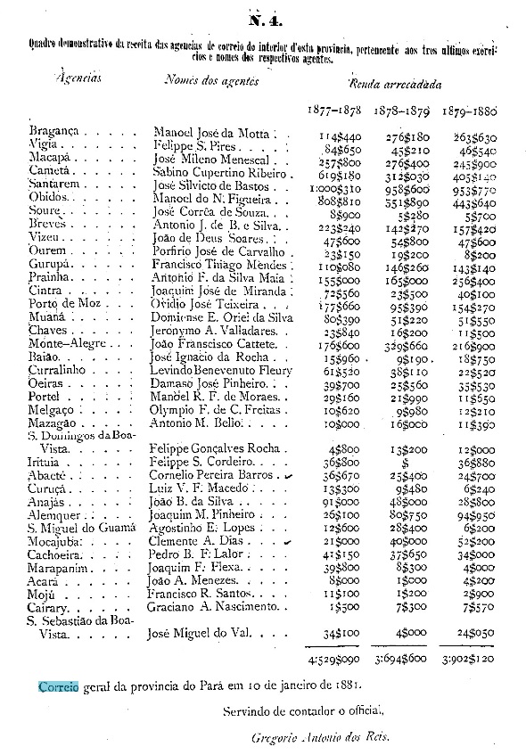
The local post office was established in 1883, as can be read in the provincial president’s report for the following year:
Relatório do Presidente da Provincia, 1884
So far, no imperial postmark has appeared. For cancels with S. João dos Geraes, see SBA-0050.
Almanak Laemmert, 1913
Andere Namen: São João dos Geraes (SBA-0050), Coribe (1938)
São João dos Geraes war ein Arraial (Weiler) im Município von Carinhanha, der über 900 km westlich der Provinzhauptstadt Salvador da Bahia entfernt lag. Im August 1880 stieg er zur Freguesia und im August 1923 zur Vila do Rio Alegre auf, aber acht Jahre später wurde der Ort als Distrikt von Santa Maria da Vitória rückgestuft. 1938 kam der neue Name Coribe dazu, und seit August 1958 ist Coribe ein Município. Der Name soll in der Tupi-Guarani-Sprache Fröhlicher Fluss (Rio Alegre) bedeuten.
Das örtliche Postamt entstand 1883, wie im Bericht des Provinzpräsidenten fürs folgende Jahr zu lesen ist:
Relatório do Presidente da Provincia, 1884
Bisher wurde kein Poststempel der Kaiserzeit gesichtet. Für Stempel mit S. João dos Geraes siehe SBA-0050.
Villiers de l’Ile Adam: Carta (…) da Provincia do Espirito Santo, 1850
Other names: Santa Cruz, Aracruz (1943)
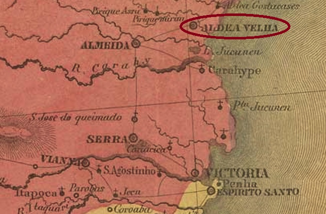
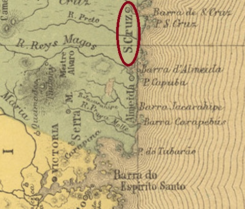
The former Freguesia of Aldeia Velha (= Old Village) was established in December 1837 in the municipality of Nova Almeida, situated 75 km north of the province capital Vitoria. In April 1848 it ascended to a villa in own municipality, named Santa Cruz, which became a town in March 1891. In December 1943 the toponym was changed to the actual Aracruz.
According to Nova Monteiro (Administrações e Agencias Postaes do Brasil Imperio, in Brasil Filatelico/RJ, 1934-5; Reprint SPP 1994-1999), the local post office was created in October 1831. This would mean there is a possible cancel featuring Aldeia Velha, which apparently has yet never appeared. Since Paulo Novaes (agenciaspostais.com.br) lists this agency with creation date “ca. 1856”, it may have been closed in the meantime. For cancels featuring Santa Cruz see SES-0165.
Atlas do Imperio do Brasil, 1868
Andere Namen: Santa Cruz, Aracruz (1943)
Die alte Freguesia von Aldeia Velha (= Altes Dorf) entstand im Dezember 1837 im Município von Nova Almeida und lag 75 km nördlich der Provinzhauptstadt Vitoria. Im April 1848 wurde sie zu einer eigenständigen Villa unter dem Namen Santa Cruz, die im März 1891 zur Stadt wurde. Im Dezember 1943 wechselte der Ortsnamen zum heutigen Aracruz.
Laut Nova Monteiro (Administrações e Agencias Postaes do Brasil Imperio, in Brasil Filatelico/RJ, 1934-5; Reprint SPP 1994-1999) entstand das örtliche Postamt im Oktober 1831. Dadurch wäre die Existenz eines Stempels mit Aldeia Velha möglich, der allerdings bisher nicht aufgetaucht ist. Da Paulo Novaes (agenciaspostais.com.br) diese Agentur mit Entstehungsjahr “ca. 1856” auflistet, könnte sie zwischendurch mal geschlossen gewesen sein. Für Poststempel mit Santa Cruz siehe SES-0165.
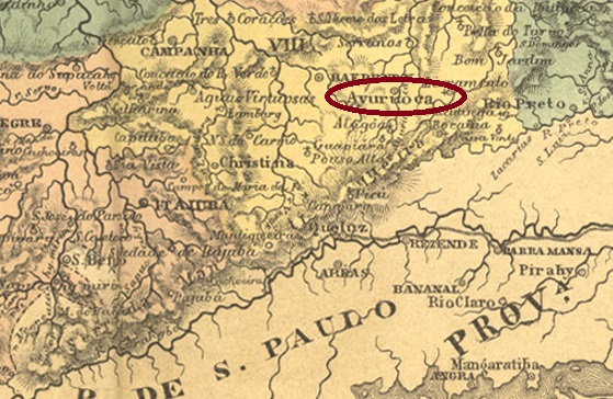
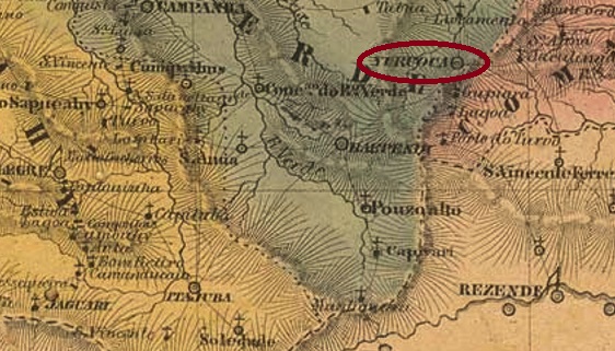
The Freguesia of N. Sra. da Conceição de Ayuruoca was founded in February 1724 at the Vila of Baependi and was located on the west bank of the river Aiuruoca, over 270 km from the future provincial capital Ouro Preto. The place name has its origin in the Tupi-guarani language and means house of the purple parrot. Aiuruoca (as it is written today) became a vila in August 1834 and a town in July 1868.
Three dates of origin for the local post office have been found. First in June 1833, as Nova Monteiro writes in Administrações e Agencias Postaes do Brasil Imperio (Brasil Filatelico/RJ, 1934-5; Reprint SPP 1994-1999). Then in 1838, as listed in the Directory of Imperial Post Offices (Tabella das Agencias do Correio do Imperio, Rio de Janeiro, 1885). And lastly in July 1847, as listed in the postal report (Relatório Postal) for the year 1887.
Three postmarks were also found for the 19th century. The oldest of them is AMG-3760a, which occurs in sepia, was probably in circulation from the beginning until at least 1843 and was already presented in the RHM catalogue under P-MG-01:
AMG-3760a (RHM P-MG-01)
It was followed by AMG-3335a, listed in Paulo Ayres’ Catálogo de Carimbos Brasil-Império, (S. Paulo, 1937, 1942) under no. 1555 and used on D. Pedro issues from 1866:
AMG-3335a (P.A. 1555)
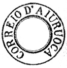
The third postmark is AMG-0165a (image from the internet): A double circle with the inscription AYURUOCA at the top. The dates in the middle have so far been found for the period 1889-1896.
Villiers de l’Ile Adam: Carta (…) da Provincia de Minas Geraes, 1849
Die Freguesia von N. Sra. da Conceição de Ayuruoca wurde im Februar 1724 bei der Vila von Baependi gegründet und lag am Westufer des Flusses Aiuruoca, über 270 km der späteren Provinzhauptstadt Ouro Preto entfernt. Der Ortsname hat seinen Ursprung in der Tupi-guarani-Sprache und bedeutet Haus des violetten Papageis. Aiuruoca (wie man heute schreibt) wurde im August 1834 zur Vila und im Juli 1868 zur Stadt erhoben.
Drei Entstehungstermine fürs örtliche Postamt wurden gefunden. Erstmals im Juni 1833, wie Nova Monteiro in Administrações e Agencias Postaes do Brasil Imperio (Brasil Filatelico/RJ, 1934-5; Reprint SPP 1994-1999) schreibt. Dann 1838, wie im Verzeichnis der kaiserlichen Postämter (Tabella das Agencias do Correio do Imperio, Rio de Janeiro, 1885) aufgelistet wurde. Und zuletzt im Juli 1847, wie im Postbericht (Relatório Postal) fürs Jahr 1887 zu lesen ist.
Auch drei Poststempel wurden fürs 19. Jahrhundert gefunden. Der älteste davon ist AMG-3760a, der in Sepia vorkommt, wohl vom Anfang an bis mindestens 1843 im Umlauf war und bereits im RHM-Katalog unter P-MG-01 vorgestellt wurde:
AMG-3760a (RHM P-MG-01)
Ihm folgte AMG-3335a, der im Paulo Ayres’ Catálogo de Carimbos Brasil-Império, (S. Paulo, 1937, 1942) unter Nr. 1555 aufgelistet wurde und auf D. Pedro-Ausgaben von 1866 zu finden ist:
AMG-3335a (P.A. 1555)
Der dritte Poststempel ist AMG-0165a (Abb. aus dem Internet): Ein Doppelkreis mit der Inschrift AYURUOCA oben. Die Daten in der Mitte wurden bisher für den Zeitraum 1889-1896 gefunden.
Villiers de l’Ile Adam: Carta (…) da Provincia do Rio de Janeiro, 1850
Other names: São Pedro da Aldeia (see also SRJ-0020), Sapiatiba
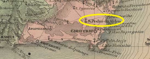
The history of this settlement, which is very old by Brazilian standards, began as early as May 1617, when the Aldeia de São Pedro was founded on the northeastern shore of Lake Araruama near Cabo Frio, about 140 east of the future capital Rio de Janeiro. In December 1795, it became a freguesia, which rose to become a villa called Sapiatiba in September 1890. However, the Tupi word meaning rich in clay did not find favour, and a good two years later the old place name returned. São Pedro da Aldeia has been a town since December 1929.
There are two dates for the origin of the local post office. The Imperial Mail Register (Tabella das Agencias do Correio do Imperio) of 1885 gives the year 1820 for it, while Nova Monteiro (Administrações e Agencias Postaes do Brasil Imperio, in Brasil Filatelico/RJ, 1934-5; Reprint SPP 1994-1999) lists the agency from June 1829.
Both postmarks of the imperial period found so far bear the place name Aldeia de S. Pedro and were already rpesented under SRJ-0020. They are also presented here. ARJ-0020a/SRJ-0200a also occurs in blue, was in use from about 1829 to 1884 and was already presented by Paulo Ayres (Catálogo de Carimbos Brasil-Império, S. Paulo, 1937, 1942) under no. 1193:
ARJ-0020a/SRJ-0200a (P. A. 1193)
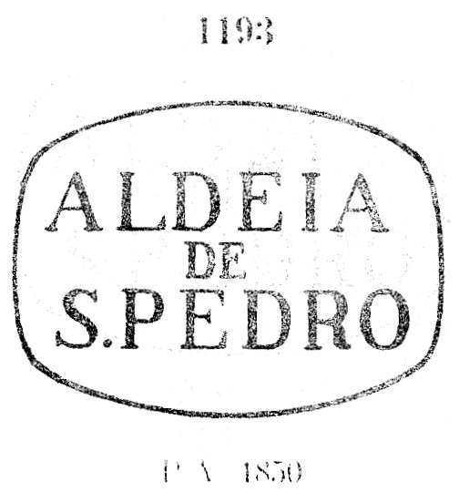
ARJ-0020b/SRJ-0200b (agenciaspostais.com.br) is a simple double circle with the inscription A. DE S. PEDRO at the top. The only known copy is dated 1884 in the centre.
Atlas do Imperio do Brasil, 1868
Andere Namen: Aldeia de São Pedro, Sapiatiba
Die Geschichte dieser für brasilianische Verhältnisse sehr alten Siedlung fing bereits im Mai 1617 an, als die Aldeia de São Pedro am Nordostufer des Araruama-Sees bei Cabo Frio gegründet wurde, ca. 140 östlich der künftigen Hauptstadt Rio de Janeiro entfernt. Im Dezember 1795 wurde daraus eine Freguesia, die im September 1890 zu einer Villa namens Sapiatiba aufstieg. Das Tupi-Wort, das reich an Lehm bedeutet, fand jedoch kein Gefallen, und gut zwei Jahre später kam der alte Ortsname zurück. Seit Dezember 1929 ist São Pedro da Aldeia eine Stadt.
Hier gibt es zwei Jahresangaben für die Entstehung des örtlichen Postamts. Das Verzeichnis der kaiserlichen Postämter (Tabella das Agencias do Correio do Imperio) von 1885 nennt dafür das Jahr 1820, während Nova Monteiro (Administrações e Agencias Postaes do Brasil Imperio, in Brasil Filatelico/RJ, 1934-5; Reprint SPP 1994-1999) die Agentur ab dem Juni 1829 auflistet.
Beide bisher gefundenen Poststempel der Kaiserzeit tragen den Ortsnamen Aldeia de S. Pedro und wurden bereits unter São Pedro da Aldeia (SRJ-0020) besprochen. Sie werden hier nochmals vorgestellt. ARJ-0020a/SRJ-0200akommt auch in blau vor, war von ca. 1829 bis 1884 in Gebrauch und wurde bereits durch Paulo Ayres(Catálogo de Carimbos Brasil-Império, S. Paulo, 1937, 1942) unter Nr. 1193 bekannt gemacht:
ARJ-0020a/SRJ-0200a (P. A. 1193)
ARJ-0020b/SRJ-0200b (agenciaspostais.com.br) ist ein einfacher Doppelkreis mit der Inschrift A. DE S. PEDRO oben. Das einzige Exemplar ist 1884 in der Mitte datiert.
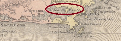
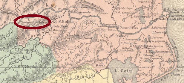
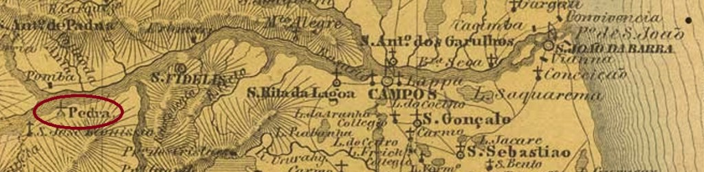
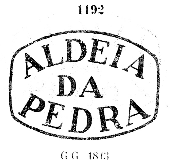
Other names: São José de Leonissa (SRJ-1425), Itaocara (1891)
See also Pedra (R. Koester: Carimbologia XXX)
This village was from March 1850 the district of S. José de Leonissa da Aldeia da Pedra, located on the south bank of the river Paraíba do Sul in the municipality of S. Fidélis, about 260 km northwest of the imperial capital Rio de Janeiro. In October 1890, it became the Villa of Itaocara, since then in own municipality. The word Itaocara comes from the Tupi language and means village of stones (Aldeia da Pedra).
According to Nova Monteiro (Administrações e Agencias Postaes do Brasil Imperio, in Brasil Filatelico/RJ, 1934-5; Reprint SPP 1994-1999), the local post office was created in November 1833 under the name Aldeia da Pedra. The imperial postmark ARJ-0015a also occurs in blue and was already presented by Paulo Ayres in Catálogo de Carimbos Brasil-Império (S. Paulo, 1937, 1942) under no. 1192:
ARJ-0015a (P.A. 1192) 1843-1869
The toponym changed to S. José de Leonissa around 1866. For cancels under this name see SRJ-1425.
Villiers de l’Ile Adam: Carta (…) da Provincia do Rio de Janeiro, 1850
Andere Namen: São José de Leonissa (SRJ-1425), Itaocara (1891)
Siehe auch Pedra (R. Koester: Carimbologia XXX)
Diese Ortschaft war ab März 1850 der Distrikt von S. José de Leonissa da Aldeia da Pedra, am Südufer des Flusses Paraíba do Sul im Município von S. Fidélis gelegen, ca. 260 km nordwestlich der kaiserlichen Hauptstadt Rio de Janeiro entfernt. Im Oktober 1890 stieg sie zur Villa von Itaocara, seitdem auch ein eigener Município. Das Wort Itaocarastammt aus der Tupi-Sprache und bedeutet Dorf der Steine (Aldeia da Pedra).
Laut Nova Monteiro (Administrações e Agencias Postaes do Brasil Imperio, in Brasil Filatelico/RJ, 1934-5; Reprint SPP 1994-1999) wurde das örtliche Postamt im November 1833 unter dem Namen Aldeia da Pedra gegründet. Der kaiserliche Poststempel ARJ-0015a kommt auch in blau vor und wurde bereits durch Paulo Ayres in Catálogo de Carimbos Brasil-Império (S. Paulo, 1937, 1942) unter Nr. 1192 vorgestellt:
ARJ-0015a (P.A. 1192) 1843-1869
Der Namenswechsel zu S. José de Leonissa erfolgte ca. 1866. Für Stempel unter diesem Namen siehe SRJ-1425.