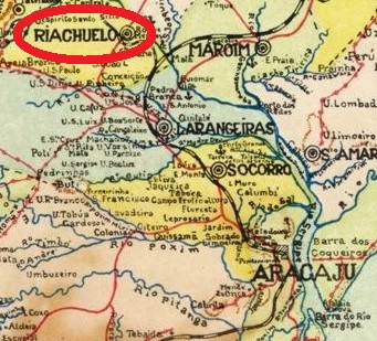
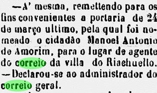
The Villa of Riachuelo was created in March 1874 through the emancipation from the municipality of Laranjeiras, of which it had been the district of Nossa Senhora dos Pintos. The new name obviously intended to celebrate the victory in the Riachuelo naval battle (1865) in the war against Paraguay (1864-1870). The region was relatively wealthy, due to prospering sugar cane farms, so the new political leaders soon began exert pressure to have a post office created. And this was already installed in March 1877:
Jornal do Aracaju, April 14, 1877
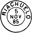
Two early cancels are known. RSE-0140a, which has dates between 1885 and 1890, was already described by Paulo Ayres in 1937 and is easily recognizable through a somewhat offside placed final O:
Paulo Ayres, 1937
RSE-0140b (Coll. Karlheinz Wittig) also presents a double circle with locality name and date like the former, but shows in addition a rhombus ornament below. The using dates, between 1895 and 1899, indicate a possible republican origin.
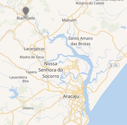
Wikimedia – OpenStreetMap
Die Villa von Riachuelo wurde im März 1874 nach der Emanzipierung von Laranjeiras gegründet, davor war sie der Distrikt von Nossa Senhora dos Pintos. Der neue Ortsname sollte natürlich wieder an den Sieg der brasilianischen Flotte gegen Paraguay (im Tripel-Allianz-Krieg 1864-1870) bei der Riachuelo-Schlacht im Fluss Paraná in 1865 erinnern.
Die Gegend war durch prosperierende Zuckerplantagen relativ wohlhabend, also begannen die neuen Politikführer der Region bei der Provinzregierung Druck auszuüben, damit ein neues Postamt dort eingerichtet werden konnte. Das war dann im März 1877 soweit:
Jornal do Aracaju, 14. April 1877
Zwei frühe Abstempelungen sind überliefert. RSE-0140a hat Verwendungsdaten zwischen 1885 und 1890, wurde bereits von Paulo Ayres in 1937 vorgestellt und ist durch eine merkwürdig hängende Buchstabe O (am Ende) leicht erkennbar:
Paulo Ayres, 1937
RSE-0140b (Samml. Karlheinz Wittig) hat ebenfalls den Doppelkreis mit Name und Datum wie vor, zeigt aber zusätzlich ein rautenförmiges Ornament im unteren Bogen. Die Verwendungsdaten (bisher gefunden: zwischen 1895 und 1899) können eventuell auf einen republikanischen Ursprung hinweisen.
The Município Neutro (= Neutral Municipality) “was an administrative unit created in the Empire of Brazil, that existed in the territory corresponding to the current location of the municipality of Rio de Janeiro between August 12, 1834 (when it was proclaimed the Additional Act to the Constitution of 1824) and November 15, 1889, when was proclaimed the republic in Brazil. But it only officially ceased to exist with the promulgation of the 1891 Constitution. By the republican constitution, this administrative unit became the Federal District in 1891, whose political situation changed again when it became the state of Guanabara in 1960, and later, with the fusion of this with the state of Rio de Janeiro in 1975.”(Wikipedia)
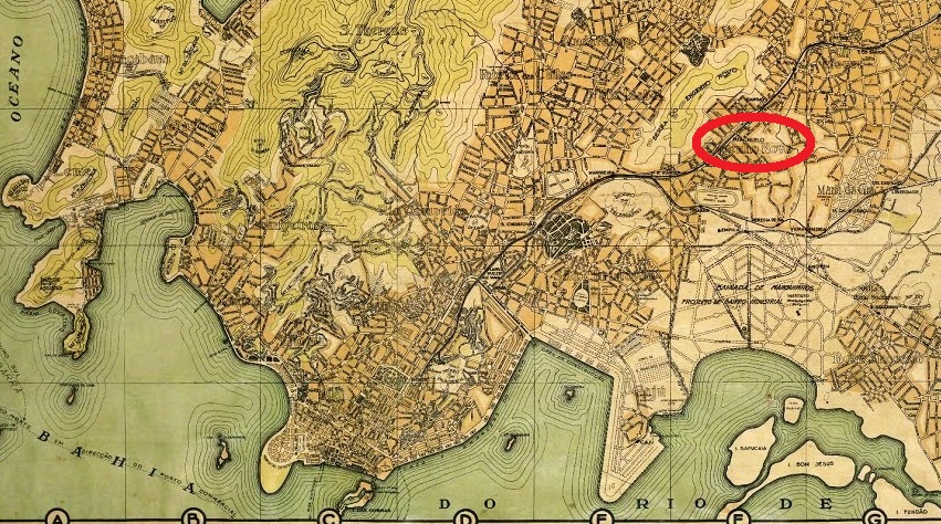
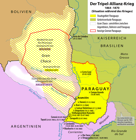
According to Ralph Giesbrecht (estacoesferroviarias.com.br), the Riachuelo station of the Estrada de Ferro D. Pedro II was installed in 1869, ca. 7 km away from the Central Line start. The name celebrates the famous naval battle of June 1865 around the Riachuelo brook in Argentina, in which the Brazilian fleet defeated the Paraguay forces, a turning point in the War of the Triple Alliance (1864-1870):
Paulo Novaes (agenciaspostais.com.br) asserts that the local post office was created on November 12, 1870, shortly after the end of the war. To date we have found three different imperial cancels; possibly, there may also be an earlier one. RMN-2035a (Coll. Paulo Novaes) presents a double circle with inscriptions RIACHUELO (above) and EST (below), separated by asterisks, and the date in the inner circle. Used 1887-1888. RMN-2035b (Coll. José A. Junges) has a double circle with the inscription EST. DE RIACHUELO above and the date in the inner circle. One single copy was found, with date 1887. RMN-2035c (Coll. José A. Junges) is similar to RMN-2035a, but now the inscription below shows (EST.), and the asterisks disappeared. Copies found for 1893-4, but possibly also used in the Empire.
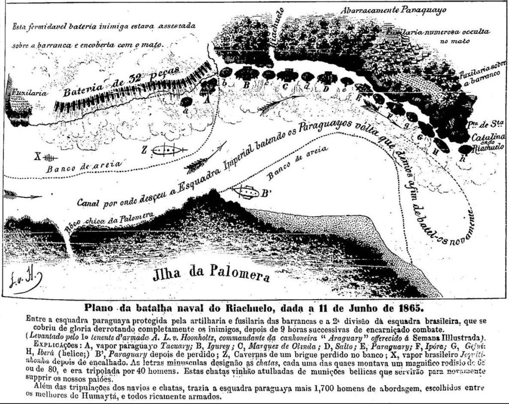
Antonio Luis v. Hoonholtz, Semana Illustrada 244, 1865
Der Município Neutro (= Neutraler Stadtbezirk) war ein kaiserliches Verwaltungsgebiet in Brasilien, der dem heutigen Município von Rio de Janeiro entspricht. Er existierte vom August 1834 bis zum Ende des Kaiserreichs im November 1889. Offiziell aber wurde die Bezeichnung erst mit dem Inkrafttreten der ersten republikanischen Verfassung in 1891 in Distrito Federal geändert, und der nächsten Wechsel erfolgte in 1960, als das Gebiet zum Bundesstaat Guanabara erklärt wurde. In 1975 fusionierten schließlich die Staaten Guanabara und Rio de Janeiro.
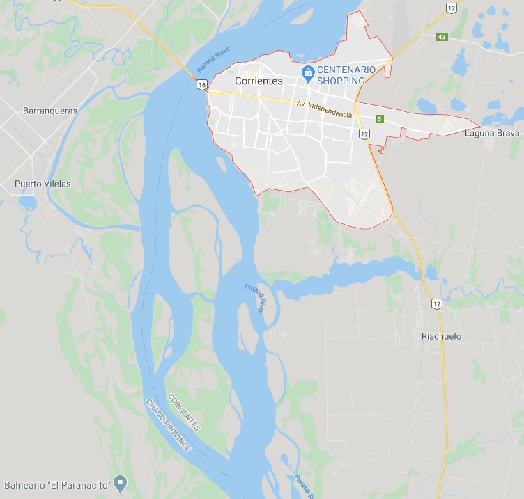
Laut Ralph Giesbrecht (estacoesferroviarias.com.br) wurde der Bahnhof Riachuelo der Estrada de Ferro D. Pedro II in 1869 in Betrieb genommen; er liegt ca. 7 km vom Startbahnhof der Linha do Centro (= Zentrale Linie) entfernt. Der Name Riachuelo soll an die berühmte Schlacht des Tripel-Allianz-Krieges um den gleichnamigen Fluss bei Corrientes in Argentinien im Juni 1865 erinnern, bei der die brasilianische Flotte die Gegner aus Paraguay geschlagen hat und damit einen Wendepunkt im Krieg einleitete:
Maximilian Dörrbecker (CC BY-SA), leider mit falscher Jahresangabe für die Riachuelo-Schlacht
Paulo Novaes (agenciaspostais.com.br) schreibt, dass das Bahnhofspostamt am 12. November 1870 entstanden ist, also kurz nach Ende des Kriegs. Bisher wurden drei verschiedene Stempel des Kaiserreichs gefunden, vermutlich gab es auch einen vierten, der in der Frühzeit des Postbetriebs verwendet wurde. RMN-2035a (Samml. Paulo Novaes) zeigt einen Doppelkreis mit den Inschriften RIACHUELO (oben) und EST (unten), von Asterisken getrennt, dazu das Datum im Innenkreis. Benutzt 1887-1888. RMN-2035b (Samml. José A. Junges) hat einen Doppelkreis mit der Inschrift EST. DE RIACHUELO oben und dem Datum, im Innenkreis. Nur ein Exemplar aus dem Jahr 1887 gefunden. RMN-2035c (Samml. José A. Junges) ähnelt RMN-2035a, nun aber sieht man hier die Inschrift in Klammern (EST.) unten, und die Asterisken sind verschwunden.
Carta da República dos Estados Unidos do Brazil, 1892
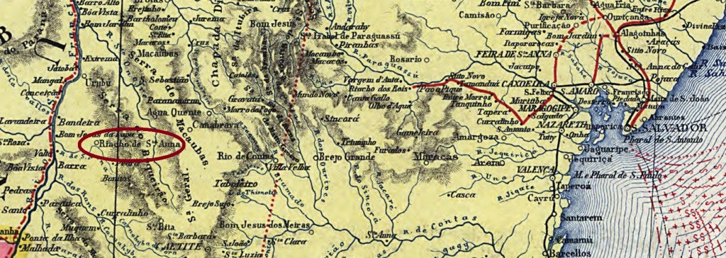
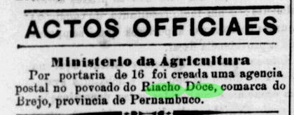
The Sant’Anna is a pacific affluent on the east bank of the São Francisco River in Bahia that has its source in the slopes of the Serra do Boqueirão. The same name was given to the Arraial de Nossa Senhora do Rosário do Riacho de Sant’Anna in 1861, a small village founded by niter miners and subordinated to Monte Alto. It is since August 1878 Villa and Município of Riacho de Sant’Anna.
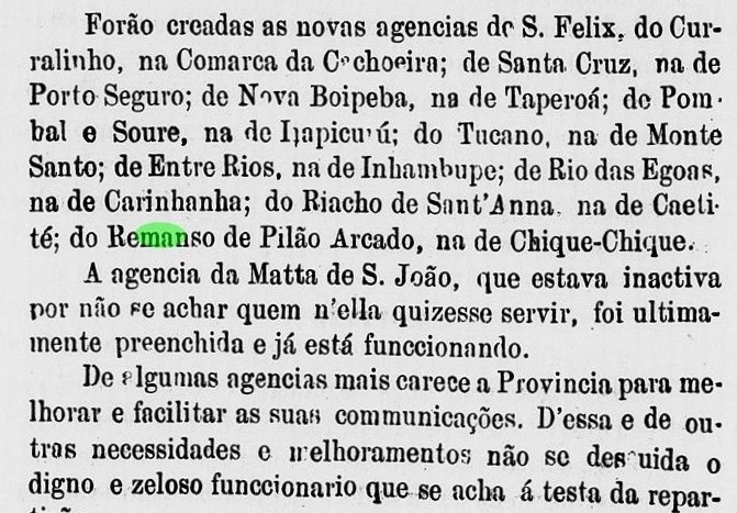
A new post office was announced in the 1876 report by the Bahia government:
Relatório do Conselho Interino do Governo da Bahia, 1876
No imperial cancel has yet appeared.
Wikiwand
Der kleiner Fluss Sant’Anna entspringt den Hängen der Serra do Boqueirão in Bahia und fließt friedlich gegen Westen bis zur Mündung in den mächtigen Rio São Francisco. Nach ihm wurde der Arraial de Nossa Senhora do Rosário do Riacho de Sant’Anna in 1861 genannt, ein von Salpeter-Bergleuten gegründetes Dorf bei Monte Alto. Seit August 1878 ist Riacho de Sant’Anna eine eigenständige Villa mit Município-Status.
Das erste Postamt wurde im Jahresbericht für 1876 der Regierung von Bahia erwähnt:
Relatório do Conselho Interino do Governo da Bahia, 1876
Bisher konnte keine Abstempelung der Kaiserzeit gefunden werden.
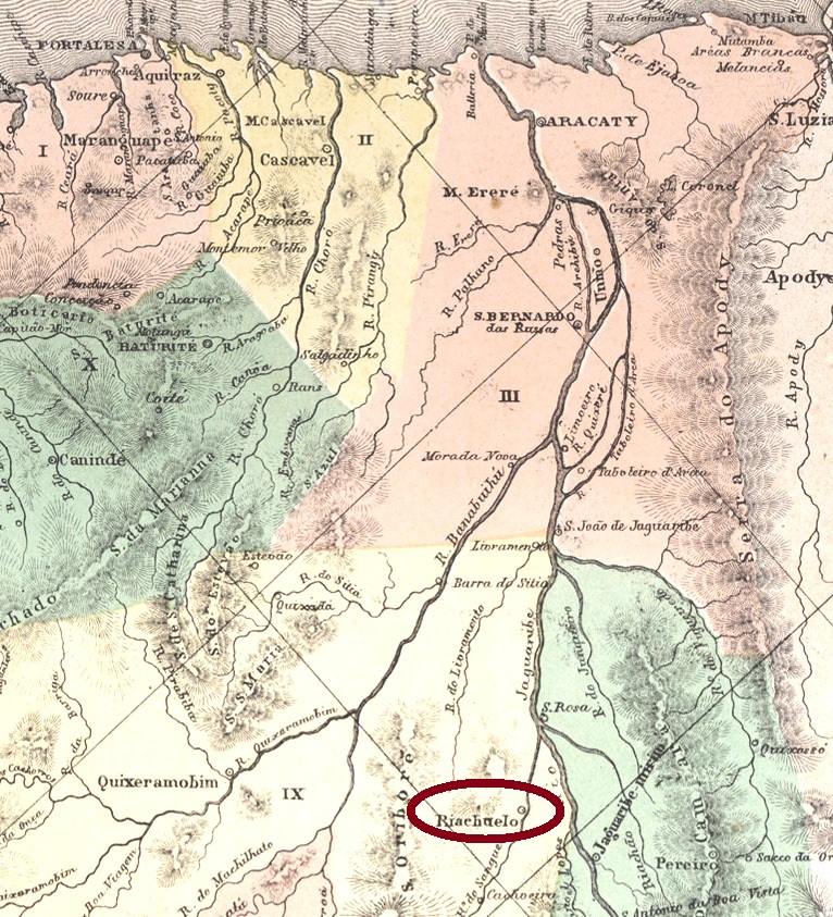
According to a local legend, the name Riacho de Sangue (= Sanguinary Brook) originated from a bloody family tragedy in the village on the homonymous stream. There might be something true in this story, because both village, since 1956 the municipality of Jaguaretama (= Homeland of the Jaguar), and brook, now Riacho Velho, have changed their names. But the artificial lake upstream which serves as water reservoir for the neighbour town of Cachoeira (since 1943: Solonópole) is still now known as Açude Riacho de Sangue, despite its official name of Boqueirão.
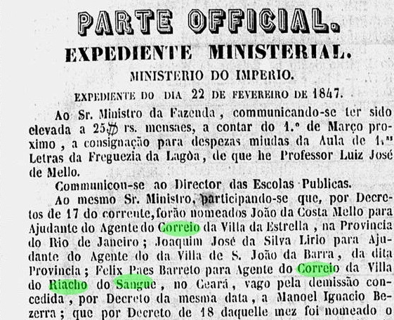
Riacho de Sangue was from 1784 on a district of the Icó municipality and was elevated to a Villa in 1833. A local post office must have been established before 1847, for at that time the postal clerk was replaced:
Gazeta Official, March 1, 1847
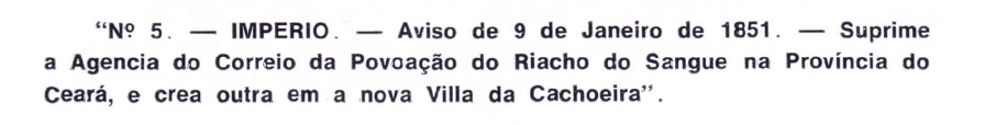
But in January 1851 the office was closed:
Aureo G. Santos: Agências dos Correios Criadas e Suprimidas em 1851, 1855, 1956 e 1857, in Brasil Filatélico #181, Rio de Janeiro, 1977
By that time, the municipality had been cancelled, and Riacho de Sangue was degraded as a district of Cachoeira in 1850.
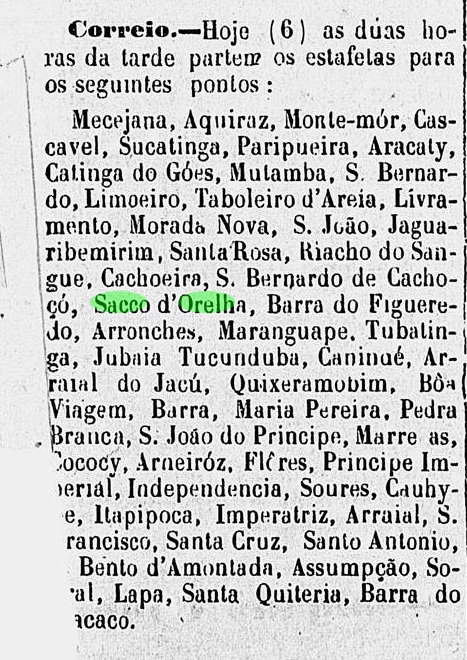
In August 1865, the village was hastily upgraded as the Município of Riachuelo, to celebrate the Riachuelo naval battle won by the Brazilian fleet two months before, during the war against Paraguay. But the deficient infrastructure could not improve so fast as political wish: by July 1870, the ancient name of Riacho de Sangue has re-emerged in the regional press, and three years later it was again a district of Cachoeira:
Pedro II, July 6, 1870
Only in September 1879 could Riacho de Sangue recover the municipality status, but the post office reopening took place only in 1884, according to the Imperial Mail Register (Tabella das Agencias do Correio do Império) of 1885.
No imperial cancel has been found to date.
Wikimedia – OpenStreetMap
Buchtest-Aktualisierung vom 22. April 2020
Die Einheimischen verbreiten gerne die Legende, nach der die Bezeichnung Riacho de Sangue (= Blutiger Bach) einer Familientragödie entstammt, die in der Ortschaft am gleichnamigen Fluss stattgefunden haben soll. Es kann durchaus Wahres daran sein, da sowohl der Ort – der seit 1956 als Município von Jaguaretama (= Heimat des Jaguars) fungiert, als auch der Bach (jetzt: Riacho Velho), ihre Namen geändert haben. Dennoch: der Stausee flussaufwärts, der als Wasserspeicher für den Nachbarort Cachoeira (der wiederum seit 1943 Solonópole heißt) ist nach wie vor als Açude Riacho de Sangue bekannt, obwohl er den offiziellen Namen Boqueirão trägt.
Riacho de Sangue war ab 1784 ein Distrikt von Icó, wurde dann eine Villa und auch ein eigener Município in 1833. Das örtliche Postamt muss noch vor 1847 entstanden sein, da in diesem Jahr der Postagent ersetzt wurde:
Gazeta Official, 1. März 1847
Das Postamt wurde aber gleich am Anfang 1851 geschlossen:
Aureo G. Santos: Agências dos Correios Criadas e Suprimidas em 1851, 1855, 1956 e 1857, in Brasil Filatélico #181, Rio de Janeiro, 1977
Zu diesem Zeitpunkt war Riacho de Sangue kein Município mehr, denn schon im Vorjahr wurde der Ort als ein Distrikt von Cachoeira abgewertet.
Im August 1865 hat man plötzlich sehr rasch gehandelt, und aus dem Distrikt von Riacho de Sangue wurde der Município von Riachuelo. So hieß die Schlacht am Fluss Paraná in Argentinien, bei der zwei Monate zuvor die brasilianische Flotte die Kriegsgegner aus Paraguay vernichtend geschlagen hatte. Leider konnte die Infrastruktur im ländlichen Ceará mit dem politischen Wunschdenken nicht mithalten, und so ab 1870 tauchte der alte Name Riacho de Sangue in der Regionalpresse wieder auf. Drei Jahre später war er wieder ein Distrikt von Cachoeira:
Pedro II, 6. Juli 1870
Erst im September 1879 konnte Riacho de Sangue den Status eines Município wieder erlangen, aber bis zur Neuröffnung eines Postamtes dauerte es dann doch bis 1884, wie das Verzeichnis der kaiserlichen Postämter (Tabella das Agencias do Correio do Império) von 1885 informiert.
Bis heute war leider kein Stempel aus der Kaiserzeit zu sehen.
Esboço da Carta Corographica da Provincia de Pernambuco, 1880
The amazing history of this small locality near the Alagoas border in Southern Pernambuco is still to be told. Until around 1870 it was an Indian reserve. Then, a dispute between Indians and farmers began, after the local government had started a land surveying project. Two years later, numerous sugar cane farmers went in clash with the indigenous population, at the end of which a new land demarcation project was set in motion.
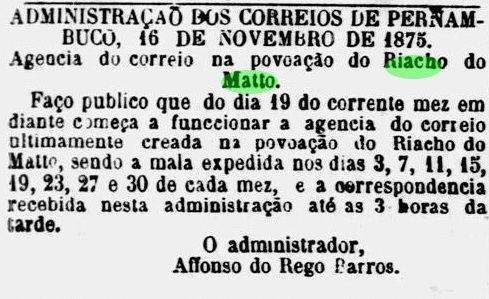
By July 1875, the former indigenous reserve had already disappeared, giving place to colonization projects, and – oddly enough- a post office was created three months later, starting operation shortly after:
A Provincia, October 6, 1875Diario de Pernambuco, November 18, 1875
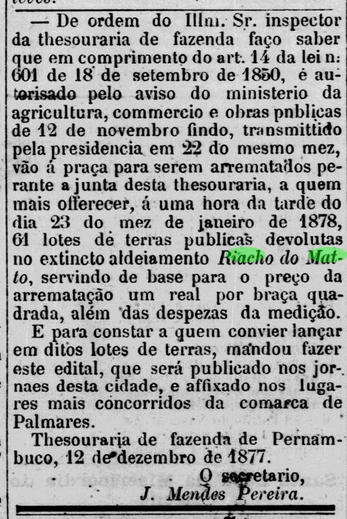
In December 1877, an allotment plan was offered for public sale through auction:
Diario de Pernambuco, December 16, 1877
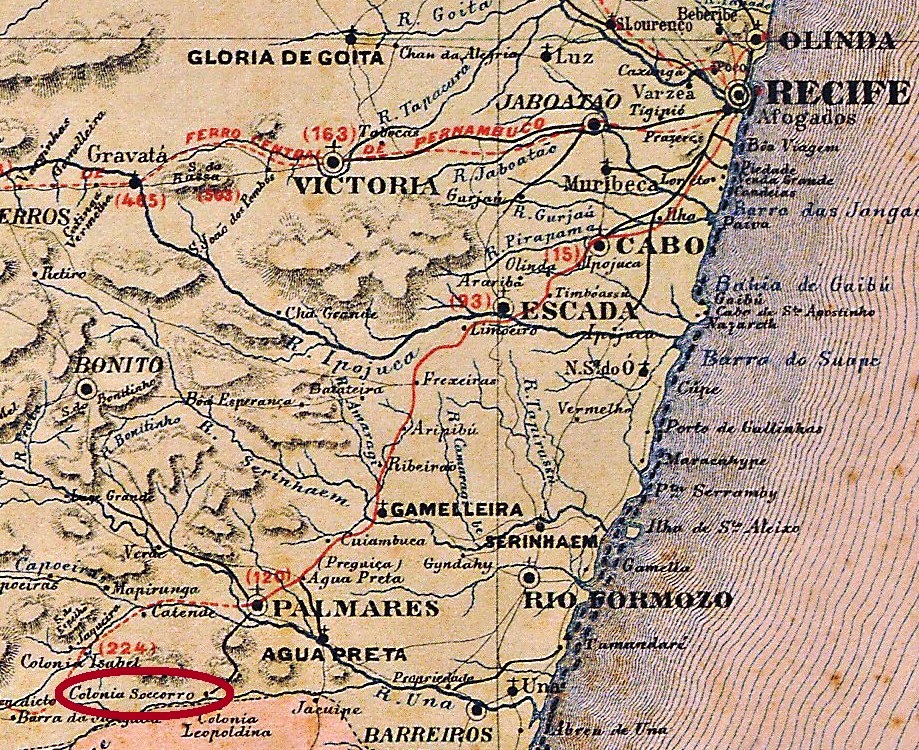
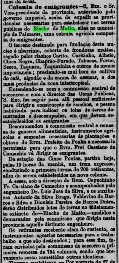
In April 1878, the first train arrived at the Cinco Pontas station, bringing ca. 700 colonists to settle down in Riacho Do Matto, about 30 km away. Most of them were refugees from the drought regions in Brazilian Northeast, but there were also poor people from Recife, who accepted to leave the province capital in change of some land. At the occasion, the new colony was renamed Colonia Soccorro (= Assistance Colony), located between two other ones, Colonia Isabel (see Koester, Carimbologia XII) and Colonia Leopoldina (see map above):
Jornal de Recife, April 5, 1878
One month later, the local population has grown to over 3,000 inhabitants, bringing many conflicts to the new community. In the eighties, even homecoming Pernambuco veterans of the war against Paraguay claimed for land in the locality.
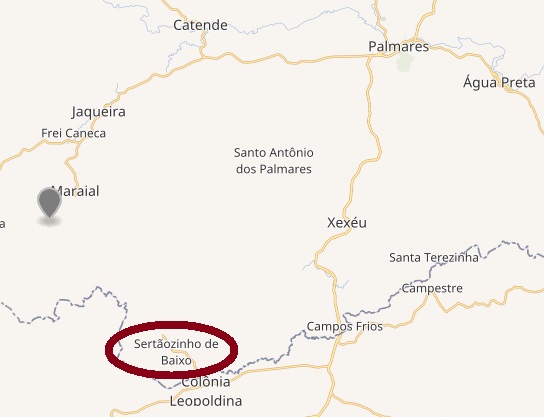
From February 1893 on this settlement, now a district of Agua Preta, was called Sertãozinho, after an ancient farm in the region, and since 1930 it was named Sertãozinho de Baixo (= Lower Sertãozinho). In 1938 Sertãozinho de Baixo became a district of the municipality of Maraial.
No imperial cancellation could be found to date for this village.
Wikimedia – OpenStreetMap
Die erstaunliche Geschichte dieser kleinen Ortschaft nahe der Alagoas-Grenze im südlichen Pernambuco wurde noch nicht erzählt. Bis ca. 1870 war sie noch ein Indianerreservat. Um diese Zeit entfachte sich ein Disput zwischen Indianern und Farmern, am dessen Ende ein Landvermessungsprojekt von der Provinzregierung entstand. In 1872 eskalierte der Streit zum offenen Konflikt, und das ganze Gebiet wurde anschließend neu demarkiert.
Bis Juli 1875 war das Indianerreservat bereits Geschichte und machte Platz einem ehrgeizigen Siedlungsplan der Regierung, der drei Kolonien vorsah. Ein Paar Monate später kündigte man schon das neue Postamt für Riacho do Matto an:
A Provincia, 6. Oktober 1875Diario de Pernambuco, 18. November 1875
Die Landparzellen wurden gleichwohl erst im Dezember 1877 zur Versteigerung öffentlich ausgeschrieben:
Diario de Pernambuco, 16. Dezember 1877
In April 1878 kam der erste Kolonistenzug am ca. 30 km entfernten Bahnhof Cinco Pontas an, um die Neubesiedlung von Riacho do Matto feierlich einzuleiten. Die meisten der neuen Einwohner waren Flüchtlinge aus den Dürregebieten in Brasiliens Nordosten. Dazu kamen aber auch viele Arme aus Recife, die überredet worden waren, mit der Aussicht auf ein Stück Land die Provinzhauptstadt zu verlassen. Diese neue Kolonie wurde Colonia Soccorro genannt, und lag zwischen Colonia Isabel (s.a. Koester, Carimbologia XII) und Colonia Leopoldina. (s. Karte zu Beginn des englischen Textes):
Jornal de Recife, 5. April 1878
Binnen eines Monates erreichte die Bevölkerungszahl über 3.000 Einwohner, was große Probleme ins soziale Gefüge der neuen Gemeinde mit sich brachte. In den 80er Jahren haben sogar Veteranen aus der Region, die zurück aus dem Krieg gegen Paraguay zurückgekehrt waren, auch ihre Landesparzellen bei der Pernambuco-Regierung beantragt.
Die Siedlung wurde in 1893 in Sertãozinho umbenannt – nach einer alten Fazenda der Region – und war nun der Villa von Água Preta unterstellt. In 1930 erhielt sie nun die aktuelle Bezeichnung, Sertãozinho de Baixo (= Untere Sertãozinho), und wurde ab 1938 ein Distrikt des neu gegründeten Município von Maraial.
Bisher konnte kein Stempel aus der Kaiserzeit für diese Ortschaft gefunden werden.
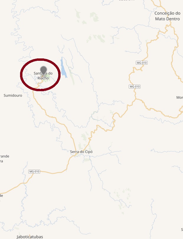
Santo Antonio do Riacho Fundo was a district of the municipality of Conceição do Mato Dentro (later Conceição do Serro) in Minas Gerais until 1911, when it passed to Santa Luzia. In 1938 it became a district of Jaboticatubas, emancipating with an own municipality in 1962.
Paula Sobrinho (História Postal de Minas Gerais, Belo Horizonte, 1997) has found two dates for the creation of the post office: October 23, 1879 (apud Relatório dos Correios of 1890) and November 23, 1889 (according to the Boletim Postal), and states that the first mail agent was nominated only in July 1894.
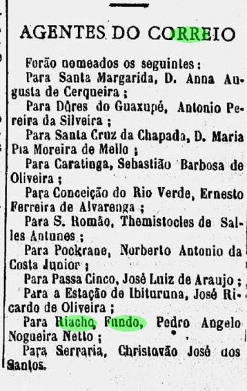
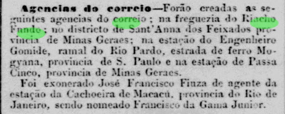
Further research in the regional press could confirm neither a creation in 1879 nor the 1894 first agent. Already in 1891, a postal agent was nominated for Riacho Fundo:
A Ordem, December 5, 1891
He was possibly not the first one, for the earliest note on the creation of the post office dates back to 1889:
Jornal do Commercio, Rio de Janeiro, October 25, 1889
Since no earlier record neither a cancel from the Empire period have been found to date, possibly the year 1879 in Relatório dos Correios (1890) would be a misprint. And a Riacho Fundo cancel with date before November 15, 1889 must be very rare, if it exists.
Wikimedia – Open Street Map
Santo Antonio do Riacho Fundo war bis 1911 ein Distrikt der Gemeinde (Município) Conceição do Mato Dentro (später: Conceição do Serro) in Minas Gerais. Danach gehörte dieser Ort zu Santa Luzia bis 1938, als er ein Distrikt von Jaboticatubas wurde, bevor er 1962 eigenständig und ein eigener Município wurde.
Paula Sobrinho (História Postal de Minas Gerais, Belo Horizonte, 1997) nannte gleich zwei Daten für die Entstehung des dortigen Postamtes: den 23.10.1879 (apudRelatório dos Correios von 1890) und den 23.11.1889 (laut Boletim Postal) und schrieb, der erste Postangestellte wurde erst im Juli 1894 eingesetzt.
Eine Suche in der Regionalpresse konnte weder die Entstehung in 1879 noch den ersten Agenten in 1894 bestätigen. Allerdings wurde ein Postangestellter bereits in 1891 dorthin abkommandiert:
A Ordem, 5. Dezember 1891
Dieser war vermutlich nicht der erste, da über die Entstehung eines Postamtes in Riacho Fundo schon im Jahr 1889 berichtet wurde:
Jornal do Commercio, Rio de Janeiro, 25. Oktober 1889
Die Suche nach einem früheren Datum fürs Postamt hat bisher kein Ergebnis gebracht. Daher könnte es sein, dass die Jahresangabe 1879 im Relatório dos Correios (1890) einen Druckfehler hat. Und ein Stempel aus Riacho Fundo mit Datum vor dem 15. November 1889 muss sehr selten sein, sofern existent.
Arthur Duarte Ribeiro: Mapa do Estado de Pernambuco, 1924
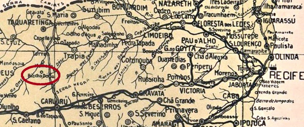
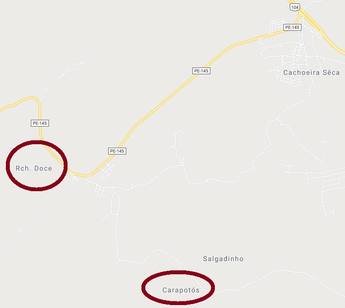
The old locality named Nossa Senhora da Conceição do Riacho Doce was a district of the municipality of Brejo da Madre de Deus, which was a Villa from 1833 on. Since 1892 it is a northern district to Caruaru, the most important town in the Pernambuco hinterland, near the Capibaribe River. In the last two centuries, it switched frequently its name between Riacho Doce and Carapotós (or Coropotós, or also Caropotós). The coropotós were an Indian tribe of this region, who also named an affluent of the Capibaribe River. Actually, one can find both villages Riacho Doce and Carapotós side by side on the map, to rise the toponymic confusion. (See map below)
A postal office was created on April 16, 1885:
Jornal de Recife, April 24, 1885
The only imperial cancel of Riacho Doce found to date is quite doubtful, for RPE-0500a (Coll. José A. Junges) shows barely one third of the total cancel surface, and another cancel (from Brum/PE, cancelled May 5, 1885) was applied at least twice on the same stamp. There is a double circle with a legible RIAC inscription, but no further indication.
Google Maps
Die alte Ortschaft Nossa Senhora da Conceição do Riacho Doce war früher ein Distrikt der Gemeinde Brejo da Madre de Deus, und diese seit 1833 eine Villa. Seit 1892 ist Riacho Doce ein Distrikt nah am Fluss Capibaribe im Norden von Caruaru, der zweitwichtigsten Stadt im Pernambuco. In den letzten beiden Jahrhunderten hat diese Gemeinde immer wieder den Namen gewechselt, von Riacho Doce nach Carapotós (ou Coropotós, oder auch Caropotós) und zurück. Die Coropotós waren ein Indianerstamm im Nordosten Brasiliens, die auch einem kleinen Fluss den Namen gaben, der in den Capibaribe fließt. Heutzutage findet man sowohl den Ort Riacho Doce als auch Carapotós neben einander auf der Karte, was die Verwirrung größer macht (siehe oben).
Das dortige Postamt entstand am 16. April 1885:
Jornal de Recife, 24. April 1885
Der einzige bisher gefundene kaiserliche Stempel von Riacho Doce ist ziemlich zweifelhaft, da RPE-0500a (Samml. José A. Junges) lediglich knapp einen Drittel seiner Gesamtfläche auf der Marke hat, die wiederum mindestens zweimal einen Stempel aufweist, der woanders verpasst wurde: in Brum/PE in Mai 1885. Man sieht hier einen Doppelkreis mit der Inschrift RIAC, sonst nichts.
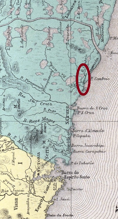
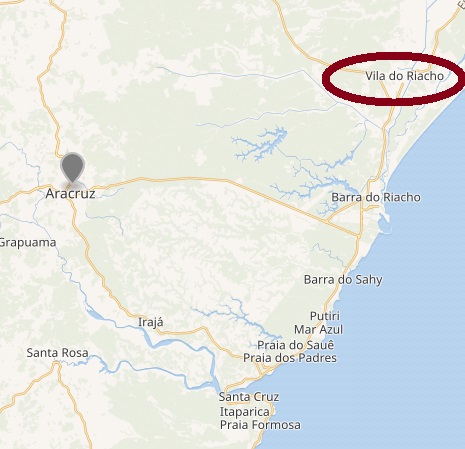
This small village with such a humble name has a remarkably long history for Brazilian standards. It began in 1557 as the Aldeia do Campos do Riacho, became an Intendência in 1828, was declared a district of Santa Cruz in 1848, was elevated to a Villa with own municipality in 1891 and returned in 1931 until now as a district of Santa Cruz, which is today called Aracruz.
The search for a date for the creation of the post office has been unsuccessful. Paulo Novaes (agenciaspostais.com.br) writes only ca. 1886, but it might also be the beginning of 1887, as the regional press reports:
A Provinica do Espirito Santo, April 14, 1887
No imperial cancellation has been found so far.
Wikimedia – Open Street Map
Andere Namen: Campos do Riacho, Vila do Riacho.
Der unscheinbare Name dieser kleinen Ortschaft lässt nicht vermuten, dass sie für brasilianische Verhältnisse ganz schön alt ist. Ihre Geschichte begann bereits 1557 mit der Gründung der Aldeia do Campos do Riacho. In 1828 bekam sie eine eigene Intendência (Ortsverwaltung), dann wurde sie in 1848 ein Distrikt von Santa Cruz (heute: Aracruz), und in 1891 wurde sie sogar eine Villa mit dem Status eines Município. Aber in 1931 kehrte sie dann doch zurück als Distrikt von Santa Cruz.
Ein genaues Datum fürs Postamt konnte bisher nicht ermittelt werden. Paulo Novaes (agenciaspostais.com.br) schreibt dazu lediglich ca. 1886, aber es könnte auch Anfang 1887 gewesen sein, wie man von der Regionalpresse erfahren kann:
A Provincia do Espirito Santo, 14. April 1887
Keine kaiserliche Abstempelung wurde bisher gefunden.
A riacho is a small rio, i.e. a brook, whereas a riachão is supposed to be a bigger riacho, but not so big as a real river. These shades are meaningful in Brazil, a land with huge rivers but also with streams that eventually disappear during drought periods in the Northeast.
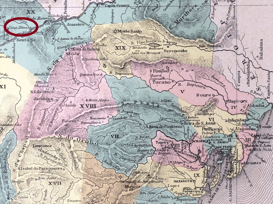
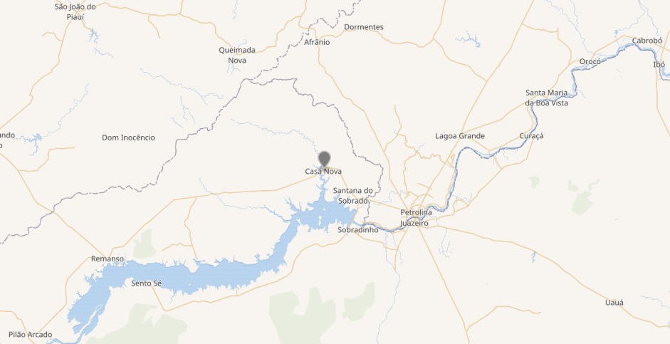
The district of São José do Riacho da Casa Nova was established 1873 in the municipality of Remanso de Pilão Arcado (see RBA-0800). It became the Município of São José da Casa Nova in 1879 and simplified the toponymy to Casa Nova in 1931. Originally, Casa Nova was not the famous Italian seducer, but a riacho, an affluent to the São Francisco River, which has given its name to the locality. Since 1976, the original village was relocated due to the flood by the Sobradinho barrage of the São Francisco, just like the old towns of Remanso, Pilão Arcado and Sento Sé (see actual map below).
The Bahia Interim Government Council reports in 1877 the creation of a post office in Casa Nova the year before:
Relatorio do Conselho Interino do Governo da Bahia, 1877
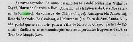
This information can be confirmed by the regional press:
O Monitor, November 30, 1876
We are looking forward to seeing the first imperial cancel from this post office.
Wikimedia – Open Street Map
Anderer Name: Casa Nova
Ein riacho ist ein kleiner rio, also ein Bach, während ein riachão zwar ein größer riacho sein sollte, allerdings nicht so groß wie ein richtiger Fluss. Diese Abstufungen ergeben ihren Sinn in einem Land wie Brasilien, mit gigantischen Strömen aber auch mit kleinen Wasserwegen, die während der Dürreperioden im Nordosten des Landes eventuell verschwinden können.
Der Distrikt von São José do Riacho da Casa Nova entstand 1873 innerhalb der Gemeindeverwaltung von Remanso de Pilão Arcado (s. a. RBA-0800). In 1879 wurde daraus ein eigener município, São José da Casa Nova, der in 1931 seinen Namen in Casa Nova vereinfachte. Und Casa Nova war nicht der berüchtigte venezianischer Verführer, sondern eben ein Nebenfluss des Rio São Francisco, der seinen Namen der Ortschaft gab. In 1976 ein von der brasilianischen Militärdiktatur gebauter Staudamm bei Sobradinho am São Francisco überflutete die ganze Region und siedelte dabei mindestens vier historische Gemeinden um: Pilão Arcado, Remanso, Sento Sé und auch Casa Nova (s. aktuelle Karte oben).
Der Bericht des Provisorischen Regierungsrates für 1877 in Bahia erwähnte ein im Jahr zuvor entstandenes Postamt:
Relatorio do Conselho Interino do Governo da Bahia, 1877
Das wiederum wird von der Regionalpresse bestätigt:
O Monitor, 30. November 1876
Wir freuen uns schon auf den ersten kaiserlichen Stempel von Riacho da Casa Nova. Hoffentlich überstand er die Überflutung.
Carta da República dos Estados Unidos do Brasil, 1892
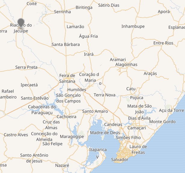
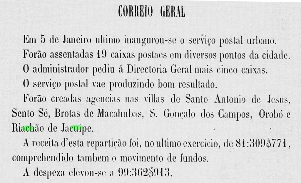
Riachão do Jacuípe is a town of some 35 thousand inhabitants on the Jacuípe River about 200 km northwest of Salvador da Bahia. It was the parish of Nossa Senhora da Conceição do Riachão de Jacuípe (founded 1847), that became a Vila in 1878. According to the Bahia Provisory Government Report for 1881, a post office had been recently created at that time:
Relatório dos Trabalhos do Conselho Interino do Governo da Bahia, 1881
RBA-0590a (Coll. José A. Junges) is the only imperial cancel found to date: a double circle with the inscription RIACHÃO DE JACUIPE above and the date in the inner circle. A single copy found for 1890.
Wikimedia – Open Street Map
Riachão do Jacuípe ist eine kleine Stadt mit ca. 35 tausend Einwohnern am Fluss Jacuípe etwa 200 km nordwestlich der Landeshauptstadt Salvador da Bahia. Sie war früher die Pfarrei Nossa Senhora da Conceição do Riachão de Jacuípe (gegründet 1847), dann wurde sie eine Vila in 1878. Der Bericht des Provisorischen Rats an der Regierung von Bahia für 1881 erwähnt ein kurz davor entstandenes Postamt der Vila:
Relatório dos Trabalhos do Conselho Interino do Governo da Bahia, 1881
RBA-0590a (Samml. José A. Junges) bleibt bisher die einzige kaiserliche Abstempelung von dort: ein Doppelkreis mit der Inschrift RIACHÃO DE JACUIPE oben und dem Datum im Innenkreis. Ein einziges Exemplar aus dem Jahr 1890 gefunden.