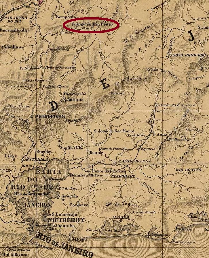
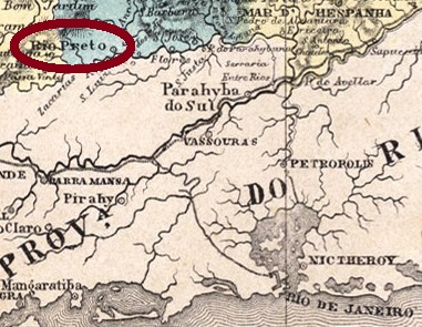
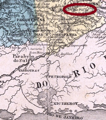
This Rio Preto (= Black River) emerges from the Serra with the same name, in northern Rio de Janeiro province. Recent researches have brought into light that this locality may be identical with São José do Rio Preto (RRJ-1460). So will the post office and its cancels be discussed there, as long as no cancels appears featuring only RIO PRETO.
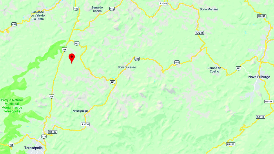
Google Maps
Buchausgabe-Textaktualisierung vom 16. Mai 2020
Dieser Rio Preto (= Schwarzer Fluss) entspringt dem gleichnamigen Gebirge im Norden der Provinz Rio de Janeiro. Aktuelle Forschungsergebnisse deuten darauf an, dass diese Ortschaft identisch mit São José do Rio Preto (RRJ-1460) sein kann. Dadurch werden Postamt und Stempel dort besprochen, solange kein Stempel auftaucht, wo nur RIO PRETO zu lesen ist.
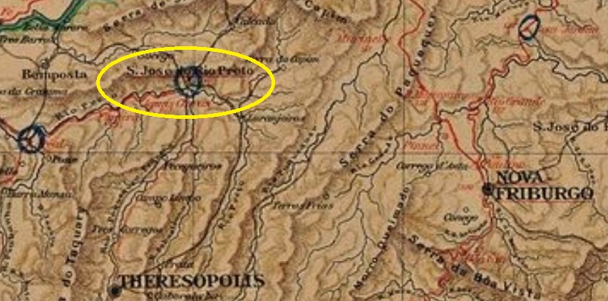
This is another mysterious post office at the end of the Brazilian Empire which appeared after the publishing of Carimbologia (Q-R) and apparently remained active only for a short time. The Rio Preto station of the Estrada de Ferro Príncipe do Grão-Pará (not the Rio Preto station of the Companhia Estrada de Ferro União Valenciana, at the border with Minas Gerais) was built in November 1886 as the final stop of the Areal-S. José do Rio Preto Branch. As the name reveals, it was located on the east bank of the Rio Preto, which flows from the mountains between Teresópolis and Nova Friburgo into the Piabanha River. The railroad went in 1890 to the Estrada de Ferro Leopoldina and stopped operations in 1947. Now both tracks and station are removed (estacoesferroviarias.com.br).
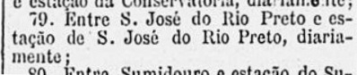
The earliest mention of a post office in the station was found in the Rio press in November 1888. A mail courier line (#79) was supposed to operate between the Rio Preto train station and the Villa of São José do Rio Preto. This could mean the station post office was opened around that time:
Gazeta de Noticias, November 6, 1888
Thanks to the philatelist Paulo Novaes, who provided the image above and helped decisively on the disambiguation of the Rio Preto train stations in Rio de Janeiro.
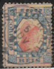
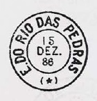
We don’t know either when it was closed, but since a single cancel, RRJ-2044a (image: Filatélica Minas Gerais-stamp auction) has been found with date November 5, 1891, we presume the post office has operated at least two years long:
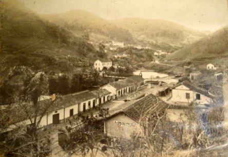
RRJ-2044aca.1940 (Photo P.P. Resende, apud estacoesferroviarias.com.br)
Textaktualisierung vom 16. Juni 2020
Hier haben wir wieder ein rätselhaftes Postamt aus der Spätzeit des Kaiserreichs, das nach dem Erscheinen von Carimbologia (Q-R) aufgetaucht ist und scheinbar eine kurze Betriebsdauer erlebte. Der Bahnhof Rio Preto der Estrada de Ferro Príncipe do Grão-Pará (nicht der Bahnhof Rio Preto der Companhia Estrada de Ferro União Valenciana, an der Grenze zu Minas Gerais) wurde im November 1886 gebaut, als Endstation der Areal-S. José do Rio Preto-Abzweigung. Wie der Name schon sagt, lag er am Ostufer des Rio Preto, der in den Bergen zwischen Teresópolis und Nova Friburgo entspringt und in den Fluss Piabanha mündet. Die Bahnlinie ging 1890 in Besitz der Estrada de Ferro Leopoldina über und beendete den Betrieb in 1947. Nun sind Schienen und Bahnhaus entfernt (estacoesferroviarias.com.br).
Die früheste Erwähnung eines Bahnhofspostamts in Rio Preto wurde in der Rio-Presse mit Datum November 1888. Eine Post-Stafettenlinie sollte die Strecke zwischen dem Bahnhof Rio Preto und die Villa von São José do Rio Preto übernehmen. Das könnte bedeuten, das Bahnhofspostamt entstand um diese Zeit:
Gazeta de Noticias, 6. November 1888
Dank an den Philatelisten Paulo Novaes, der durch die obige Abbildung bei der Klärung des Sachverhalts entscheidend helfen konnte.
Wir wissen zwar weder das genaue Öffnungs- noch das Schließungsdatum, aber ein Stempel mit Datum 5. November 1891 ist inzwischen aufgetaucht: RRJ-2044a (Abb.: Filatélica Minas Gerais-Briefmarkenauktion) deutet an, das Postamt hatte mindestens zwei Jahre lang geöffnet:
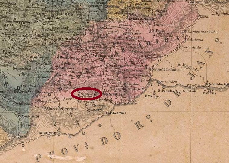
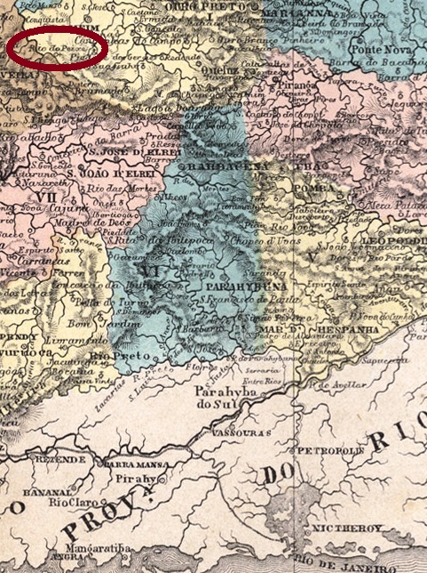
The parish of Nosso Senhor dos Passos de Rio Preto do Presídio was founded in July 1832 in southern Minas Gerais, near the Serra da Mantiqueira and about 300 km away from the province capital Ouro Preto. Presidio suggests the intention of making the settlement as an open prison.
Within 26 years Rio Preto was elevated four times to a villa: in 1844, 1850, 1857 and 1870. In-between, it lost the political autonomy in 1846, 1854 and 1864, a sign of political and economic instability. Finally, in September 1871 it achieved the status of a town. At that time, Rio Preto must have been more important than now. The Imperial Mail Guide (Guia Postal do Império) of 1880 lists it with over 15 thousand inhabitants, the triple of nowadays.
Reflecting the political changes, the local post office was created at least twice: in September 1846 (acc. to Nova Monteiro) and in August 1855, as stated by Paula Sobrinho (História Postal de Minas Gerais, Belo Horizonte, 1997) and the Imperial Mail Register (Tabella das Agencias do Correio do Império) of 1885. Two imperial cancels are known: the earlier one, RMG-2160a, was already presented by Paulo Ayres (Catálogo de Carimbos – Brasil Imperio, São Paulo, 1937), under #1439, and can be found with dates until 1876:
RMG-2160a, Paulo Ayres #1439
It was followed by RMG-2160b (Coll. José A. Junges), a double circle with the inscription RIO PRETO above and the date inside. Exemplars found are dated 1885-1898.
Villiers de l’Ile Adam: Mappa (…) da Provincia de Minas Geraes, 1849
Die Pfarrei Nosso Senhor dos Passos de Rio Preto do Presídio wurde im Juli 1832 im südlichen Minas Gerais gegründet, nahe der Serra da Mantiqueira und etwa 300 km von der Provinzhauptstadt Ouro Preto entfernt. Das Wort Presídio deutet an, die Siedlung sollte als offene Vollzuganstalt dienen.
Binnen 26 Jahren stieg Rio Preto viermal zur Villa auf: in 1844, 1850, 1857 und 1870. Zwischendurch ging dreimal die politische Autonomie verloren: in 1846, 1854 und in 1864, was man als ein Zeichen von politischen und wirtschaftlichen Unruhen deuten kann. Schließlich bekam Rio Preto in 1871 das Stadtrecht. Zu der Zeit war die Stadt wohl wichtiger als heute: der kaiserliche Postführer (Guia Postal do Império) von 1880 listet sie mit über 15 tausend Einwohnern auf, das Dreifache als jetzt.
So instabil wie die politischen Verhältnisse war wohl auch das Postwesen. Das örtliche Postamt wurde mindestens zweimal gegründet: Im September 1846 (laut Nova Monteiro) und im August 1855, wie Paula Sobrinho (História Postal de Minas Gerais, Belo Horizonte, 1997) und die Tabelle der kaiserlichen Postämter vom 1885 (Tabella das Agencias do Correio do Império) berichten. Zwei Stempel aus dieser Zeit sind überliefert. Der frühere ist RMG-2160a, der bereits durch Paulo Ayres (Catálogo de Carimbos – Brasil Imperio, São Paulo, 1937) unter Nr. 1439 vorgestellt wurde, und mit Daten bis 1876 gefunden wurde:
RMG-2160a, Paulo Ayres 1439
Sein Nachfolger ist RMG-2160b (Samml. José A. Junges), ein Doppelkreis mit der Inschrift RIO PRETO oben und dem Datum im Innenkreis. Die gefundenen Exemplare tragen Daten zwischen 1885 und 1898.
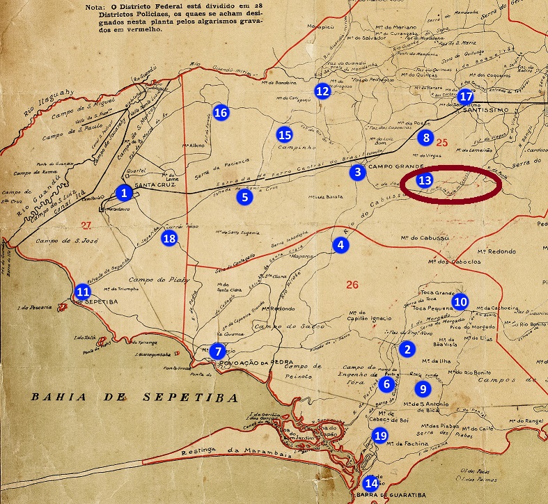
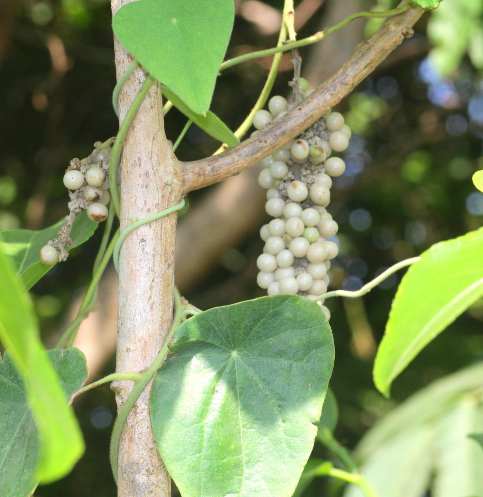
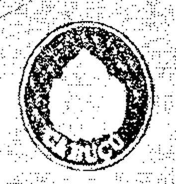
The word Cabuçu with its multiple spelling variants has undoubtedly tupi Indian origin and two main meanings. The botanical one would describe a Brazilian bush plant also called Guajabara (Coccoloba peltata, family Polygonaceae, see below); whereas the zoological interpretation would be the common name for a big wasp.
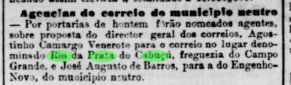
Rio da Prata do Cabuçu (= Silver River of Cabuçu) was a small village in the Campo Grande west outskirts of Rio, which originated from a big coffee and sugar cane farm. According to Paulo Novaes (agenciaspostais.com.br), there were three post offices related to Cabuçu in the Rio province, including the Município Neutro (=neutral municipality), but Rio da Prata do Cabuçu was the only one among them which operated in the Empire. It was given a post office in May 1882, and the first clerk was soon presented by the local press:
Jornal do Commercio, May 16, 1882
Although this agency remained active until ca. 1963, the only cancel, RMN-0065a, was reported by R. Koester in Carimbologia VII, and presents the imperial seal:
Das Wort Cabuçu in ihren unterschiedlichen Schreibvarianten hat zweifellos indianischen (tupi) Ursprung und zwei Hauptdeutungen. Die botanische davon wäre ein Busch, in Brasilien auch Guajabara genannt (Coccoloba peltata, Familie Polygonaceae, Abb. siehe oben); während die zoologische Deutung eine große Wespe wäre.
Rio da Prata do Cabuçu (= Silberner Fluss von Cabuçu) war eine kleine Siedlung bei Campo Grande am westlichen Rand des Município Neutro (= Neutraler Bezirk) in der Provinz von Rio de Janeiro, die aus einer großen Kaffee- und Zuckerrohrplantage entstanden war. Laut Paulo Novaes (agenciaspostais.com.br) gab es drei Postämter mit Cabuçu in der Provinz Rio, aber Rio da Prata do Cabuçu war das einzige davon, das bereits im Kaiserreich aktiv war. Das Postamt entstand im Mai 1882, und der erste Angestellte wurde gleich in der Presse vorgestellt:
Jornal do Commercio, 16. Mai 1882
Obwohl die Agentur bis ca. 1963 in Betrieb blieb, wurde der einzige Stempel, RMN-0065a, mit dem kaiserlichen Siegel, von R. Koester in Carimbologia VII gezeigt:
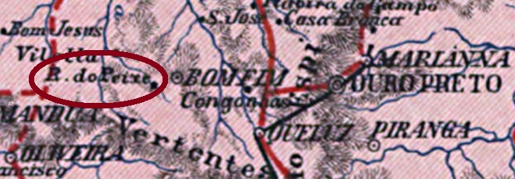
Other name: Nossa Senhora das Necessidades do Rio do Peixe (see also R. Koester: Carimbologia XXVIII)
The freguesia of Nossa Senhora das Necessidades do Rio do Peixe (= Our Lady of the Necessity of the Fish River) was founded in May 1855 in the municipality of Entre Rios, about 150 km west of the provincial capital Ouro Preto. In December 1938 it passed to the municipality of Passa Tempo (=Pastime), before acquiring political autonomy in December 1953, as the municipality of Piracema. This tupi-guarani word means “upstream fish migration”.
Reinhold Koester and Paula Sobrinho agree that the post office was established in December 1881. One sole cancel is known: RMG-3812a (Coll. José A. Junges) has a double circle with the inscription RIO DO PEIXE DE ENTRE RIOS above and a cross ornament below, which is formed by four leaflets. Dates, between 1886 and 1890, are in the centre.
Carta da Republica dos Estados Unidos do Brazil, 1892
Anderer Name: Nossa Senhora das Necessidades do Rio do Peixe (siehe auch R. Koester: Carimbologia XXVIII)
Die Freguesia von Nossa Senhora das Necessidades do Rio do Peixe (= Unsere Liebe Frau des Elends vom Fisch-Fluss) wurde im Mai 1855 im Município von Entre Rios gegründet, ca. 150 westlich von der Provinzhauptstadt Ouro Preto entfernt. In Dezember 1938 ging sie in den Município von Passa Tempo (= Zeitvertreib) über, bevor die politische Emanzipierung im Dezember 1953 stattfand. Da wurde aus Rio de Peixe der Município von Piracema, ein Wort der tupi-guarani- Sprache, das „Fischwanderung flussaufwärts“ bedeutet.
Reinhold Koester und Paula Sobrinho sind sich darüber einig, dass das Postamt im Dezember 1881 entstand. Ein einziger Stempel ist bisher bekannt: RMG-3812a (Samml. José A. Junges) hat einen Doppelkreis mit der Inschrift RIO DO PEIXE DE ENTRE RIOS oben und einem Ornament in Kreuzform unten, das aus vier Blättchen besteht. Die Daten sind in der Mitte und gehen von 1886 bis 1890.
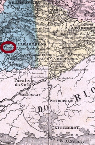
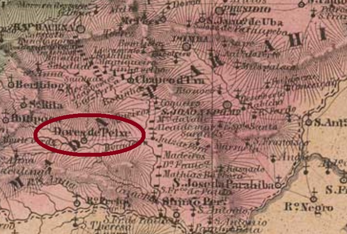
Other names: Dores do Rio do Peixe (see R. Koester: Carimbologia XVI), Lima Duarte (see R. Koester: Carimbologia XXVI)
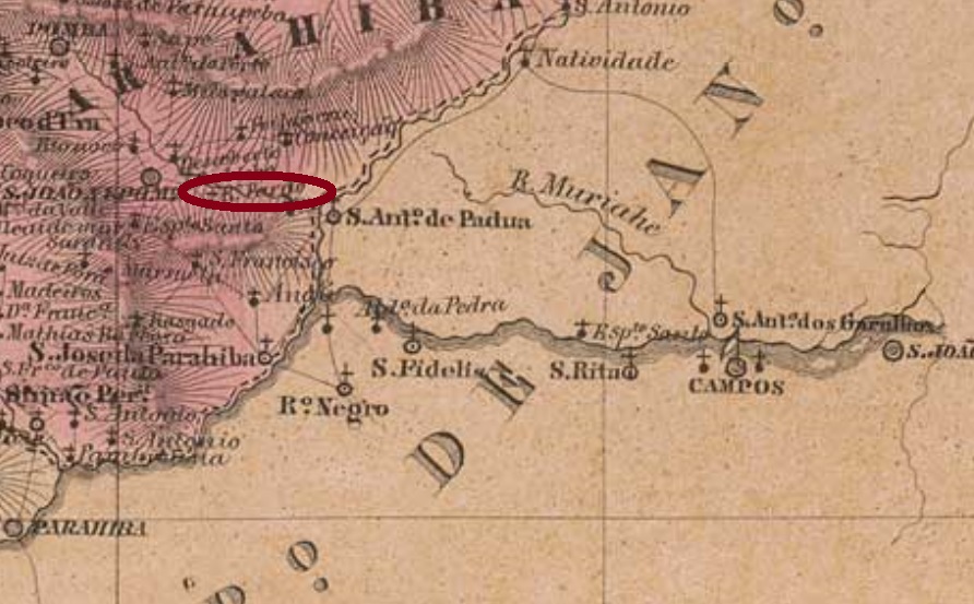
There were at least four localities in the imperial Minas Gerais and other two in the São Paulo province whose names included RIO DO PEIXE (=Fish River, RdP): Espírito Santo do RdP and Penha do RdP in São Paulo; Nossa Senhora das Dores do RdP, Nossa Senhora das Necessidades do RdP (identical with RdP de Entre Rios, see RMG-3812), Santo Antonio do RdP and São Domingos de RdP, in Minas Gerais. We assume that the post office we are looking for must have the oldest creation date, in order to dispense with further specifications on its cancels. So it must refer to Nossa Senhora das Dores do Rio do Peixe, which was a district of the municipality of Barbacena since June 1859, and ascended to a villa with political autonomy, named Rio do Peixe, in October 1881. Three years later it changed again the name, to the actual Lima Duarte.
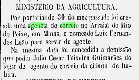
The searches for the creation date and for the cancels of this village have brought enigmatic results. We have found three different dates for this agency. Nova Monteiro (Administrações e Agências Postais do Brasil Império, 1798/1869, in Brasil Filatélico 18-21, 1934-5, Reprint SPP, 1994-9) writes June 30, 1864, which is confirmed by the press:
Correio Sergipense, July 20, 1864
On the other hand, Paula Sobrinho (História Postal de Minas Gerais, Belo Horizonte, 1997) states the office was created on September 27, 1866, which is confirmed by R. Koester (Carimbologia XVI). Finally, the Imperial Mail Register (Tabella das Agencias do Correio do Império) of 1885 lists this agency as created in 1872. If we consider that this small village (ca. 2 thousand inhabitants by 1880, according to the Imperial Mail Guide / Guia Postal do Império for the same year) was seriously involved in the Liberal Revolution of 1842, it is quite plausible that it had to close its post office more than once in the 19th century.
The local postal cancels are also challenging. A single cancel showing RIO DO PEIXE has to date appeared, which was presented by Wolfgang Maassen (Cancellations on Bull’s Eyes, in Brasilien, 140 Jahre Briefmarken, Lohmar, 1983, pp. 85 and 132) without naming the image source. Allegedly it was applied on a Bull’s Eye of 60 Réis, i.e. ca. 20 years before the opening of the earliest post office with this name. Besides, the provided image is not clear enough for verifying. For these reasons, it was not possible to present this cancel in the Carimbologia (Q-R) print edition:
W. Maassen, op.cit.
A later cancel featuring DORES DO R. DO P. and dated 1885 or 1886, was already shown by R. Koester under Dores do Rio do Peixe (Carimbologia XVI).
Villiers de l’Ile Adam, 1849
Buchtext-Aktualisierung vom 10. Mai 2010
Andere Namen: Dores do Rio do Peixe (siehe R. Koester: Carimbologia XVI), Lima Duarte (siehe R. Koester: Carimbologia XXVI)
Im brasilianischen Kaiserreich gab es mindestens vier Ortschaften in Minas Gerais und weitere zwei in der Provinz São Paulo, die RIO DO PEIXE (=Fisch-Fluss, RdP) in ihren Namen trugen: Espírito Santo do RdP und Penha do RdP in São Paulo; Nossa Senhora das Dores do RdP, Nossa Senhora das Necessidades do RdP (identisch mit RdP de Entre Rios, siehe RMG-3812), Santo Antonio do RdP und São Domingos de RdP, in Minas Gerais. Wir nehmen an, dass das hier gesuchte Postamt das älteste in dieser Liste sein soll, um weitere Bezeichnungen auf dem Stempel überflüssig zu machen. Damit wären wir auf Nossa Senhora das Dores do Rio do Peixe gekommen. Dieser war ab Juni 1859 ein Distrikt vom Município von Barbacena, der im Oktober 1881 zur Villa do Rio do Peixe mit Verwaltungsautonomie aufstieg. Drei Jahre später erhielt er den heutigen Namen Lima Duarte.
Die Suchen nach dem Postamt und nach den Stempeln erbrachten rätselhafte Ergebnisse. Allein fürs Entstehungsdatum wurden drei verschieden Angaben gefunden. Nova Monteiro (Administrações e Agências Postais do Brasil Império, 1798/1869, in Brasil Filatélico 18-21, 1934-5, Reprint SPP, 1994-9) schreibt den 30. Juni 1864, was durch die Presse bestätigt wird:
Correio Sergipense, 20. Juli 1864
Auf der anderer Seite sagt Paula Sobrinho (História Postal de Minas Gerais, Belo Horizonte, 1997), dass dieses Postamt am 27. September 1866 entstanden ist, was durch R. Koester (Carimbologia XVI) bestätigt wird. Schließlich listet das Verzeichnis der kaiserlichen Postämter (Tabella das Agencias do Correio do Império) von 1885 die Agentur mit Entstehungsjahr 1872. Wenn wir die turbulente Geschichte dieses kleinen Dorfes (ca. zweitausend Einwohner in 1880, laut Kaiserlichem Postführer / Guia Postal do Império für 1880) betrachten, das in der Liberalen Revolution von 1842 eine wichtige Rolle spielte, ist es daher fast verständlich, dass das örtliche Postamt im 19. Jahrhundert mehrmals geschlossen werden musste.
Die überlieferten Abstempelungen bringen eine weitere Herausforderung mit sich. Ein einziger Stempel mit der schlichten Angaben RIO DO PEIXE ist bisher aufgetaucht. Dieser wurde durch Wolfgang Maassen (Stempel auf Ochsenaugen, in Brasilien, 140 Jahre Briefmarken, Lohmar, 1983, S.. 85 und 132) ohne Quellenangabe fürs Bild vorgestellt. Angeblich wurde der Stempel auf ein 60 Réis-Ochsenauge aufgetragen. Dies wäre aber ca. 20 Jahre vor der Postamteröffnung geschehen. Außerdem ist die gelieferte Abbildung nicht klar genug, um bestätigt zu werden. Aus diesen Gründen war es nicht möglich, diesen Stempel in die Carimbologia (Q-R)- Printausgabe zu übernehmen:
W. Maassen, op.cit.
Eine spätere Abstempelung mit DORES DO R. DO P., datiert 1885 oder 1886, wurde bereits von R. Koester unter Dores do Rio do Peixe (Carimbologia XVI) gezeigt.
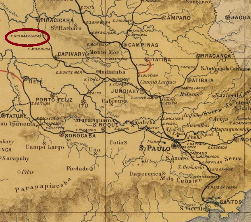
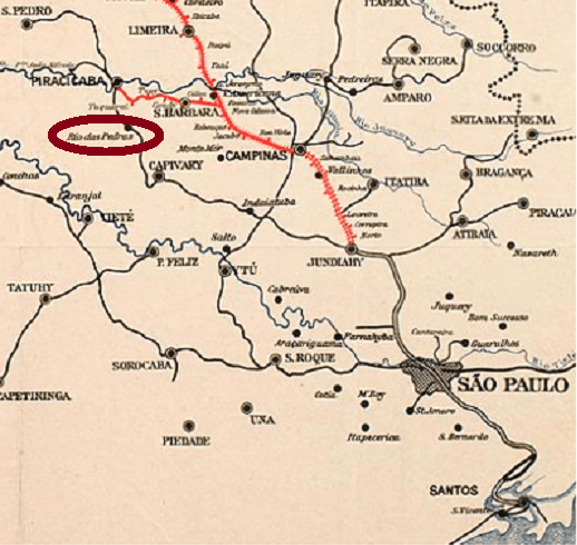
Tijuco Preto is the real name to this Rio das Pedras, a affluent to the Piracicaba River, located 160 km northwest of São Paulo. One could think the Pedras would mean Stones, as it often occurs. But the Brazilian Institute of Geography and Statistics (IBGE) tells a beautiful story about a traveller’s hostel in the ancient village, whose owner, called Pedro, had his daughters known as the Pedras… Se non è vero, è ben trovato.
Pedro’s daughters gave this way the name of the Rio das Pedras train station of the Companhia Ytuana railway, inaugurated in October 1876 in the Piracicaba branch. The settlement around it grew fast, and in April 1889 the district of Bom Jesus do Rio das Pedras was founded, which was elevated to a Villa with own municipality already in July 1894. Now it is a town with ca. 35 thousand inhabitants.
The railway control passed to the Cia. União Sorocabana e Ituana (1892-1907), followed by the Sorocabana Railway (1907-1919), the Estrada de Ferro Sorocabana (1919-1971) and by the FEPASA (1971-1984). Now the rails are removed, and the station house is demolished (estacoesferroviarias.com.br).
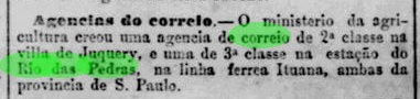
The station post office was created in April 1881, as reported by the press in Rio de Janeiro:
Jornal do Commercio, RJ, April 30, 1881
Only one imperial cancel is known, with dates between 1883 and 1891, which was already presented by Paulo Ayres (Catálogo de Carimbos – Brasil Imperio, São Paulo, 1937, p. 123):
Paulo Ayres. op.cit.Companhia Paulista
Dieser Rio das Pedras heißt eigentlich Tijuco Preto und ist ein kleiner Zufluss des Rio Piracicaba, 160 km nordwestlich von São Paulo gelegen. Man könnte annehmen, die Pedras wären die Steine im Flussbett vom Tijuco Preto. Aber die brasilianische Behörde für Geografie und Statistik (IBGE) erzählt uns die nette Geschichte, nach der ein gewisser Pedro, der dort eine Herberge für Reisende führte, einige Töchter hatte, die als Pedras bekannt wurden… Se non è vero, è ben trovato.
Nach Pedros Töchtern war auch die Bahnstation Rio das Pedras genannt, die im Oktober 1876 von der Companhia Ytuana in der Piracicaba-Abzweigung eingeweiht wurde. Die folgende Besiedlung wuchs schnell, und im April 1889 wurde der Distrikt von Bom Jesus do Rio das Pedras gegründet. Fünf Jahre später, im Juli 1894 war Rio das Pedras eine Villa im eigenen Município, und heute hat es ca. 35 Tausend Einwohner.
Die Kontrolle der Bahnlinie ging danach zu União Sorocabana e Ytuana (1892-1907) über, dann zur Sorocabana Railway (1907-1919), zur Estrada de Ferro Sorocabana (1919-1971) und schließlich zur FEPASA (1971-1984). Nun sind die Schienen ausgerissen, und das Bahnhaus gibt es auch nicht mehr. (estacoesferroviarias.com.br)
Das Bahnhofspostamt entstand im April 1881, wie die Presse aus Rio de Janeiro berichtete:
Jornal do Commercio (RJ), 30. April 1881
Nur ein Stempel aus der Kaiserzeit ist bekannt. Er hat Daten zwischen 1883 und 1891 und wurde bereits durch Paulo Ayres (Catálogo de Carimbos – Brasil Imperio, São Paulo, 1937, S. 123) vorgestellt:
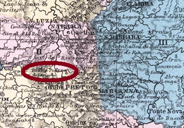
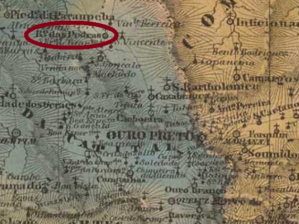
Rio de Pedras (=Stone River) was since 1846 a freguesia in central Minas Gerais, situated ca. 50 km northwest of the province capital Ouro Preto. The brook called Rio das Pedras, an affluent to the Rio das Velhas, is nowadays a water reservoir. In September 1870 the locality was elevated to a district, and in September 1923 it passed to the newly created municipality of Itabira do Campo, which is now called Itabirito. In the sixties of the 20th century Rio das Pedras was renamed Acuruí, which means stone river in the tupi-guarani language.
According to Paula Sobrinho (História Postal de Minas Gerais, Belo Horizonte, 1997), the local post office was created in August 1883. One imperial cancel is known: RMG-2125a (Coll. José A. Junges) has a double circle with the inscription RIO DE PEDRAS above and a X-shaped ornament below, formed by four diamonds. Dates in the centre, all known exemplars were used between ca. 1886 and 1890.
Villiers de l’Ile Adam, Carta (…) da provincia de Minas Geraes, 1849
Rio de Pedras (= Fluss der Steine) war seit 1846 eine Freguesia aus dem Bezirk von Ouro Preto in Minas Gerais, etwa 50 km nordwestlich von der Provinzhauptstadt gelegen. Der kleine Fluss, der dem Ort seinen Namen gab, ist ein Zufluss des Rio das Velhas, heute ist er ein Stausee. Im September 1870 stieg die Ortschaft zum Distrikt, und im September 1923 wechselte sie zum neu gegründeten Município von Itabira do Campo, der heute Itabirito heißt. Und der alte Rio das Pedras nennt sich seit den 60er Jahren Acuruí, was Fluss der Steine in der tupi-guarani-Indianersprache bedeutet.
Laut Paula Sobrinho (História Postal de Minas Gerais, Belo Horizonte, 1997) entstand das örtliche Postamt im August 1883. Ein Stempel aus der Kaiserzeit ist überliefert: RMG-2125a (Samml. José A. Junges) hat einen Doppelkreis mit der Inschrift RIO DE PEDRAS oben und ein X-förmigen Ornament unten, das aus vier kleinen Rauten besteht. Datum in der Mitte; alle bekannten Exemplare wurden zwischen ca. 1886 und 1890 abgestempelt.
This Rio Pardo in southern Minas Gerais is a quite short river of less than 50 km extension which flows into the Rio Pomba and gave the name to the district of Bom Jesus do Rio Pardo in April 1839. Fifteen years later, it passed to the new municipality of São Sebastião do Feijão Cru (= St. Sebastian of the Raw Bean, which later was renamed to Leopoldina, for obvious reasons). Between 1863 and 1869 it belonged to Mar d’Hespanha, before coming back to Leopoldina. Since December 1962 it has an own municipality, called Argirita, which according to the town website means silver stone in both latin and tupi-guarani.
The post office was created in July 1872, as Paula Sobrinho (História Postal de Minas Gerais, Belo Horizonte, 1997) tells us. Two early cancels are known. RMG-2155a (Coll. José A. Junges) has a double circle with the inscription RIO PARDO DA LEOPOLDINA above and a cross formed by four diamonds below, with date (between 1885 and 1890) in the centre. RMG-2155b (image from the internet) could be already republican and also shows a double circle. Now the inscriptions are RIO-P. DA LEOPOLDINA above and (MINAS) below, with the date (a sole known copy of 1897) in the centre.
Carta… da Provincia de Minas Geraes, Villiers de l’Ile Adam, 1849
Dieser Rio Pardo im südlichen Minas Gerais ist ein ziemlich kleiner Fluss, weniger als 50 km lang, der in den Rio Pomba fließt und im April 1839 seinen Namen dem Distrikt von Bom Jesus do Rio Pardo gegeben hat. Fünfzehn Jahre später ging die Ortschaftsverwaltung dem Município von São Sebastião do Feijão Cru (= Skt. Sebastian der Rohen Bohne, später aus verständlichen Gründen zu Leopoldina umbenannt) über. Zwischen 1863 und 1869 gehörte Rio Pardo zum Bezirk Mar d’Hespanha, dann kam die Gemeinde zu Leopoldina zurück. Seit Dezember 1962 ist es der Município von Argirita; das Wort soll nach offiziellen Angaben (Rathaus-Website) Silbernen Stein sowohl auf Latein als auch in der tupi-guarani-Indianersprache bedeuten.
Das örtliche Postamt stammt aus dem Juli 1872, wie uns Paula Sobrinho (História Postal de Minas Gerais, Belo Horizonte, 1997) berichtet. Zwei frühe Abstempelungen sind überliefert. RMG-2155a (Samml. José A. Junges) hat einen Doppelkreis mit der Inschrift RIO PARDO DA LEOPOLDINA oben und ein kreuzförmiges Ornament unten, das aus vier Rauten besteht, mit dem Datum (zwischen 1885 und 1890) in der Mitte. RMG-2155b (Abb. aus dem Internet) könnte bereits republikanisch sein und zeigt auch einen Doppelkreis. Nun liest man oben RIO-P. DA LEOPOLDINA und unten (MINAS), das Datum (ein einziges Exemplar aus 1897 bekannt) in der Mitte.
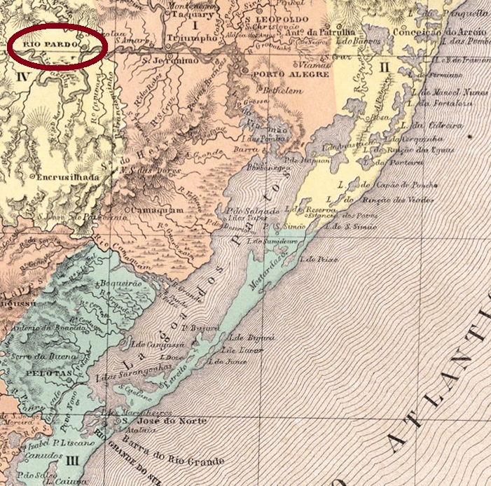
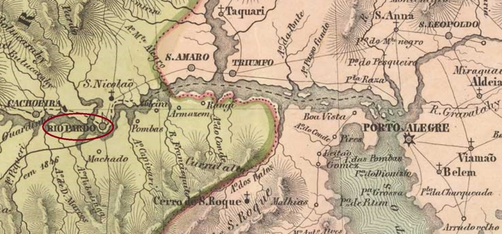
The Rio Pardo in the province of São Pedro do Rio Grande in southern Brazil is an affluent to the Jacuí River, which flows into the Lagoa dos Patos through the Lake Guaíba. The freguesia of Nossa Senhora do Rosário do Rio Pardo was founded in May 1769 on the water mouth of this Pardo River. The region is now located in central Rio Grande do Sul, but at that time it was the border between Portuguese and Spanish possessions during decades of frontier wars. Thus, the new settlement played an important role not only in defending Portuguese land but also as a bridgehead for the following territorial expansion. Rio Pardo was elevated to a Villa in April 1809 and to a town in March 1846, now it is a charming tourist destination under 200 km west from the state capital Porto Alegre.
There is also here controversial data about the creation of the post office. The Catálogo Enciclopédico de Selos e História Postal do Brasil (RHM, São Paulo, 1999) states exactly October 12, 1831, whereas the Imperial Mail Register (Tabella das Agencias do Correio do Império) of 1885 lists the agency from 1838 on. But as early as September 24, 1817, a royal document (Carta Régia) signed by D. João VI ordered a regular mail service between the provinces of S. Paulo and S. Pedro, beginning in the capital São Paulo and passing through Santos, Rio Grande and Porto Alegre until the arrival in Rio Pardo. This mail line would hardly be possible without establishing post offices on the main itinerary stops. The Carta Régia in original Portuguese can be read here:
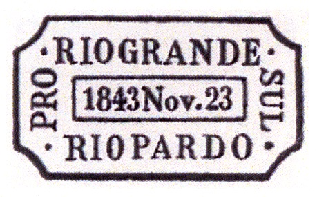
There must be at least one missing cancel from the following time, for the next cancellation, RRS-0290e (Coll. José A. Junges), in black and blue, dates between 1880 and 1886: a double circle with the inscriptions RIO PARDO above and (3) below, and date in the centre. The next cancel originates from the railway between Porto Alegre and Uruguaiana: RRS-0290f (Coll. José A. Junges) presents in green and violet a double ellipse with the inscriptions (…) DE PORTO ALEGRE above, **A URUGUAYANA** below, and RIO PARDO in the centre. Dates from 1885 on. Finally, RRS-0290g (FM) could be already republican: a double circle with the inscriptions RIO PARDO above and (S.PEDRO DO SUL) below, with the date inside. A sole copy was found, dated ca. 1893.
Villiers de L’Ile-Adam, 1847
Der Fluss Rio Pardo in der südlichen Provinz von São Pedro do Rio Grande ist ein Zufluss des Jacuí, der in die Lagoa dos Patos durch den Guaíbasee mündet. Die Freguesia de Nossa Senhora do Rosário do Rio Pardo wurde im Mai 1769 an der Mündung von diesem Rio Pardo gegründet. Die Gegend liegt ziemlich zentral im heutigen Staat Rio Grande do Sul, aber damals war sie die Grenze zwischen portugiesischen und spanischen Kolonien während Jahrzehnten des Kriegs. Darum spielte die Neusiedlung eine wichtige Rolle sowohl bei der Verteidigung der Portugiesen als auch als Brückenkopf für die folgende Landgewinnung. Rio Pardo stieg zur Villa im April 1809 und zur Stadt im März 1846 auf; nun ist es ein touristisches Städtchen unter 200 km westlich der Landeshauptstadt Porto Alegre entfernt.
Über das Entstehungsdatum des Postamtes liegen widersprüchliche Angaben vor. Der Catálogo Enciclopédico de Selos e História Postal do Brasil (RHM, São Paulo, 1999) schreibt genau den 12. Oktober 1831, während das Verzeichnis der kaiserlichen Postämter (Tabella das Agencias do Correio do Império) von 1885 gibt das Jahr 1838 an. Gleichwohl wurde bereits am 24. September 1817 ein königliches Dokument (Carta Régia) durch D. João VI unterschrieben, das die Einführung einer regulären Postlinie zwischen den Provinzen von S. Paulo and S. Pedro anordnete, die in der Provinzhauptstadt São Paulo startete, durch Santos, Rio Grande und Porto Alegre passierte und deren Ende Rio Pardo war. Diese Postlinie wäre kaum oder überhaupt nicht durchführbar ohne die Gründung von Postämtern an den wichtigsten Haltestellen. Die Carta Régia kann man im portugiesischen Original hier lesen:
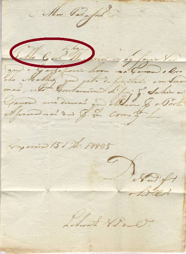
Ein Correio-Dienst wird ebenfalls in diesem Brief vom September 1825 aus Caxoeira (heute: Cachoeira do Sul) nach Rio Pardo erwähnt:
Archiv FM
Die ersten vier Abstempelungen aus Rio Pardo (RRS-0290a bis RRS-0290d) stammen aus der Vorphila-Zeit:
RRS-0290a(RHM), P-RS-19, 1832RRS-0290b(RHM), P-RS-21, 1833-1834RRS-0290c(RHM), P-RS-22, 1834-1835RRS-0290d, Paulo Ayres Nr. 1549, 1842-1852
Aus der folgenden Zeit muss es mindestens noch einen fehlenden Stempel geben, da die nächste Abstempelung, RRS-0290e (Samml. José A. Junges), Daten zwischen 1880 und 1886 vorweist: ein Doppelkreis mit der Inschrift RIO PARDO oben und eine (3) unten, dazu das Datum in der Mitte. Es folgt ein Stempel aus der Bahnlinie von Porto Alegre nach Uruguaiana: RRS-0290f (Samml. José A. Junges) kommt in grün und violett vor und zeigt eine doppelte Ellipse mit den Inschriften (…) DE PORTO ALEGRE oben, **A URUGUAYANA** unten, und RIO PARDO in der Mitte. Daten ab ca. 1885. Schließlich, RRS-0290g (FM) könnte bereits republikanisch sein: ein Doppelkreis mit den Inschriften RIO PARDO oben und (S.PEDRO DO SUL) unten, dazu das Datum in der Mitte. Nur ein Exemplar aus ca. 1893 gefunden.