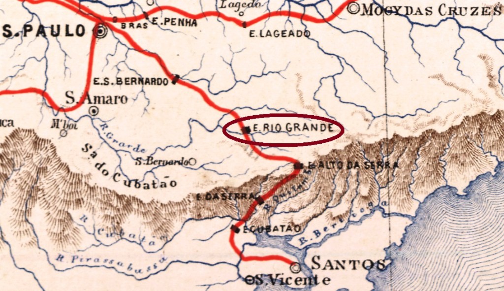
The Rio Grande in São Paulo is today better known through its Indian name Jurubatuba, which means “Happy Place”. The Jurubatuba is an affluent to the Pinheiros River, which meets the Rio Tietê in the capital, after forming the Billings water reservoir, half way between the mountains of the Serra do Mar and the metropolis.
The Rio Grande train station was built in February 1867 by the São Paulo Railway, an English enterprise that linked Jundiaí to the port of Santos and thus played a decisive role in coffee commerce and export.
At the operation start the station was situated in the municipality of São Bernardo. From 1947 until 1975 its control passed to the Estrada de Ferro de Santos a Jundiaí, from 1975 until 1994 it belonged to the Rede Ferroviária Federal, and since then it is still operating as final stop of a São Paulo CPTM rail line (estacoesferroviarias.com.br). The locality around the station grew fast: between 1953 and 1963 the station was named Icatuaçu (= Good and Big River), and since 1964 the station is called Rio Grande da Serra, in the municipality of the same name.
According to the Imperial Mail Register (Tabella das Agencias do Correio do Império) of 1885, the station post office opened in 1870. One sole imperial cancel was found: RSP-1120a (Coll. Karlheinz Wittig) presents a double circle with the inscriptions RIO GRANDE above and (ESTAÇÃO) below, with the date in the centre. Used between 1886 and 1890.
Attention! Given that recent researches have shown that both station and post office of Rio Grande in São Paulo are clearly older than station and office of the same name in Rio de Janeiro (RRJ-2043), possibly the cancel images of both stations need to be switched, as soon as further evidence comes into light.
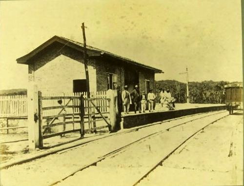
Photo: Militão A. Azevedo (estacoesferroviarias.com.br)
Druckausgabe-Aktualisierung vom 23. April 2020
Der Fluss namens Rio Grande in São Paulo ist heute eher durch seinen Indianernamen Jurubatuba bekannt. Der Jurubatuba ist ein Zufluss des Rio Pinheiros, der sich seinerseits mit dem Rio Tietê in der Hauptstadt trifft, nachdem er das mächtige Wasserreservoir Represa Billings zwischen dem Gebirge der Serra do Mar und der Metropole gebildet hat.
Der Rio Grande Bahnhof wurde im Februar 1867 durch die São Paulo Railway gebaut, ein englisches Unternehmen, das eine entscheidende Rolle im Kaffeehandel und -export spielte, in dem es die Erzeugerzentren um Jundiaí mit der Hafenstadt Santos verbunden hat.
Zu Betriebsbeginn lag der Bahnhof noch im Município von São Bernardo. Von 1947 bis 1975 ging die Kontrolle der Eisenbahnlinie zur Estrada de Ferro de Santos a Jundiaí, von 1975 bis 1994 zur Rede Ferroviária Federal, und seitdem wird die Linie von der CPTM aus São Paulo betreiben (estacoesferroviarias.com.br). Der Bahnhof ist nun Endstation, hat aber auch eine bewegte Geschichte: zwischen 1953 und 1963 hieß er Icatuaçu (= “Guter und Großer Fluss”) und seit 1964 nennen sich Bahnhof und Município Rio Grande da Serra.
Das Verzeichnis der kaiserlichen Postämter (Tabella das Agencias do Correio do Império) von 1885 nennt das Jahr 1870 für die Gründung des Postamts. Nur ein Stempel der Kaiserzeit wurde bisher gefunden: RSP-1120a (Samml. Karlheinz Wittig) zeigt einen Doppelkreis mit den Inschriften RIO GRANDE oben und (ESTAÇÃO) unten, dazu das Datum in der Mitte. Benutzt zwischen 1886 und 1890.
Bitte beachten: da es sich inzwischen herausgestellt hat, dass sowohl Bahnhof als auch Postamt aus Rio Grande in São Paulo wesentlich älter sind als der gleichnamige Bahnhof mit Postamt in Rio de Janeiro (RRJ-2043), möglicherweise muss die Zuordnung der Stempel beider Orte ausgetauscht werden, sobald weitere Forschungsergebnisse dies erforderlich machen.
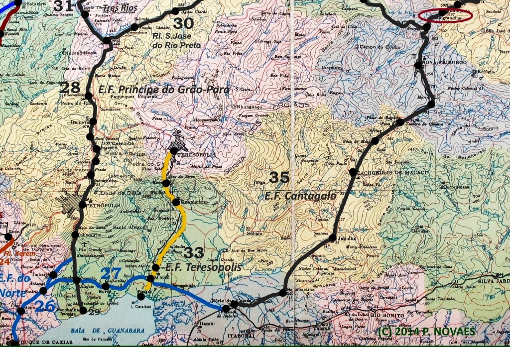
The Rio Grande train station of the Estrada de Ferro do Cantagallo railway was situated in the municipality of Nova Friburgo about 150 km northeast from Rio and started operations in May 1876, according to Ralph Giesbrecht (estacoesferroviarias.com.br). The name originated from the river: Rio Grande is an affluent to the right bank of the Paraíba do Sul River. In 1887 the railroad passed to the control of the Estrada de Ferro Leopoldina. The locality around the station grew steadily, and Estação Rio Grande became a district of Nova Friburgo in 1922. In 1943 both station and district changed their names to Riograndina. Since 1964 is the railway line off service, and the tracks have been removed (see image below).
According to the Imperial Mail Register (Tabella das Agencias do Correio do Império) of 1885, the station post office opened in 1880. One sole imperial cancel was found: RRJ-2043a (Coll. José A. Junges) presents a double circle with the inscription E. DO RIO GRANDE above and a diamond ornament below, with the date in the center. Two exemplars found for 1884.
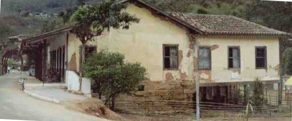
In 2002. Photo: Yvan Peixoto Jr. (estacoesferroviarias.com.br)
Der Bahnhof Rio Grande aus der Estrada de Ferro do Cantagallo lag im Município von Nova Friburgo, etwa 150 km nordöstlich von Rio de Janeiro entfernt, und wurde im Mai 1876 eingeweiht, laut Ralph Giesbrecht (estacoesferroviarias.com.br). Der Name erinnert an Rio Grande, einen Zufluss am rechten Ufer des Rio Paraíba do Sul. In 1887 wurde die ganze Bahnlinie Eigentum der Estrada de Ferro Leopoldina. Die Ortschaft um den Bahnhof wuchs ständig, und Estação Rio Grande wurde in 1922 ein Distrikt von Nova Friburgo. In 1943 wechselten sowohl Bahnhof als auch Distrikt den Namen zu Riograndina. Seit 1964 ist die Bahnlinie außer Betrieb, die Gleise wurden ausgerissen (siehe Abb. oben).
Das Verzeichnis der kaiserlichen Postämter (Tabella das Agencias do Correio do Império) von 1885 nennt das Jahr 1880 für die Gründung des Postamts. Nur ein Stempel der Kaiserzeit wurde bisher gefunden: RRJ-2043a (Samml. José A. Junges) zeigt einen Doppelkreis mit der Inschrift E. DO RIO GRANDE oben und einer Verzierung in Rautenform unten, dazu das Datum in der Mitte. Zwei Exemplare sind bekannt, beide aus 1884.
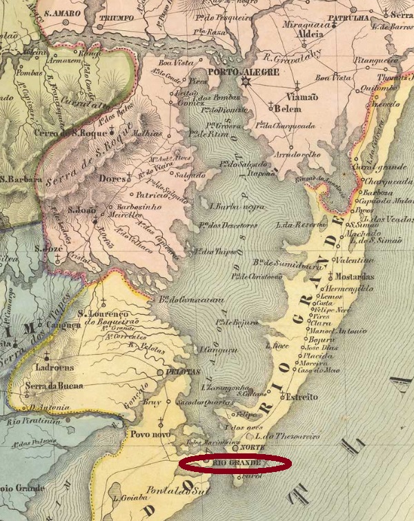
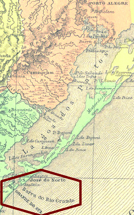
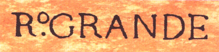
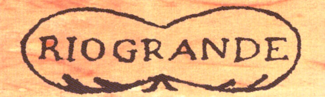
Rio Grande is the oldest settlement and the first capital in the southern province of São Pedro, now the Brazilian state of Rio Grande do Sul. It was founded in August 1736; in July 1751 it was elevated to a Villa, and in June 1836 it was declared a town.
There are two important misunderstandings about this locality. The first one refers to a supposed big river (Rio Grande), which is actually the lagoon called Lagoa dos Patos. (A similar confusion occurred in Rio de Janeiro, where the Guanabara Bay was also taken for a big river by the Portuguese). The second mistake confounds quite often the town of Rio Grande not only with the whole province, but also with the later capital Porto Alegre. This confusion is originated from the fact that capital and post administration in the province of São Pedro changed from Rio Grande to Porto Alegre in different times. So was Porto Alegre made capital already in 1773, whereas the postal service control remained in Rio Grande until ca. 1845.
Another controversy is related to the creation of the post office. Nova Monteiro asserts it took place on October 12, 1831, and the Imperial Mail Register (Tabella das Agencias do Correio do Império) of 1885 lists the year 1848. But as early as September 24, 1817, a royal document (Carta Régia) signed by D. João VI ordered a regular mail service between the provinces of S. Paulo and S. Pedro, beginning in the capital São Paulo and passing through Santos, Rio Grande and Porto Alegre until the arrival in Rio Pardo. This mail line would hardly be possible without establishing post offices on the main itinerary stops. The Carta Régia in original Portuguese can be read here:
Besides, the existence of pre-philatelic cancels dated before 1831 in Rio Grande would be another evidence of an earlier date for the creation of the local post office. Since there are no cancels found so far with dates between 1838 and 1841, possibly the agency was temporarily closed during the Farroupilha Revolution in that province (1835-1845).
The first four Rio Grande cancels are pre-philatelic:
RRS-0285a (Image from RHM), P-RS-14, Used 1814(?)-1837RRS-0285b (Image from RHM), P-RS-15, Used 1821(?)-1837RRS-0285c (Image from RHM), P-RS-16, Used 1832-1835RRS-0285d (Image from RHM), P-RS-17, Used in 1837
RRS-0285e corresponds to Paulo Ayres #1620. It exists in black and red; known exemplars used between 1842 and 1852:
RRS-0285e, HBF R8, Paulo Ayres #1620
RRS-0285f corresponds to Paulo Ayres #1621. Found on stamps with years 1858-1876.
RRS-0285f, Paulo Ayres #1621
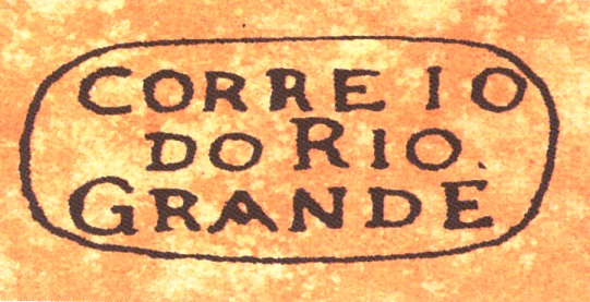
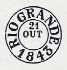
RRS-0285g (Coll. José A. Junges) is a French-Type: double circle, inscription RIO GRANDE above and star between parentheses below, date in the centre. Used 1867-1884.
RRS-0285h (image from the internet) has a double circle with inscription RIO GRANDE above and (I) below, date in the centre. Some exemplars have no date at all, others have a missing year indication. Used 1878-1886.
RRS-0285i (Coll. José A. Junges) has a double circle with RIO GRANDE above and a foliated ornament below consisting of four leaves, each one with three leaflets. Later exemplars are quite smudgy and show just a black square standing on a corner. Used 1883-1891.
RRS-0285j (Coll. Karlheinz Wittig) has a double circle with RIO GRANDE above and nothing below. Late exemplars may have no date at all (acc. to image by Marcio Monteiro), others with missing year. Used 1878-1887.
RRS-0285k (Coll. José A. Junges) has a double circle with RIO GRANDE above and a foliated ornament below consisting of four leaves, each one with three leaflets. Compared to RRS-0285i it is here diamond-shaped (rhombus). Used 1883-1892.
RRS-0285l (Coll. José A. Junges) has a double circle with RIO GRANDE above and a foliated ornament below consisting of four leaves, each one with three leaflets. Compared to RRS-0285i and RRS-0285k it has here a square form with a white cross in the centre. Used in black and blue in 1889.
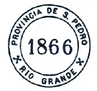
RRS-0285m (Coll. José A. Junges) has a double circle with RIO GRANDE above and (S.PEDRO DO SUL) below, with date in the centre. Used 1892-1894, so it is possibly republican.
Atlas do Imperio do Brasil, 1868
Rio Grande ist die älteste Siedlung und die erste Hauptstadt der südlichsten brasilianischen Provinz, die früher Rio Grande de São Pedro hieß und heute der stolze Bundesstaat Rio Grande do Sul ist. Die Ortschaft wurde im August 1736 gegründet; im Juli 1751 stieg sie zur Villa, und im Juni 1836 wurde ihr das Stadtrecht verliehen.
Über Rio Grande gibt es zwei wichtige Missverständnisse. Das erste bezieht sich auf einen angeblich großen Fluss (Rio Grande), der eigentlich eine riesige Lagune ist, Lagoa dos Patos genannt, etwa siebenmal größer als der Bodensee. (Eine ähnliche Verwechslung fand in Rio de Janeiro statt, wo die Portugiesen dachten, die Bucht von Guanabara wäre die Mündung eines riesigen Flusses). Das zweite Missverständnis bringt oft die Stadt Rio Grande nicht nur mit der ganzen Provinz durcheinander, sondern auch gelegentlich mit der späteren Hauptstadt Porto Alegre. Diese Konfusion wird dadurch verstärkt, dass die Umzüge der Hauptstadt und der provinziellen Postverwaltung zu verschiedenen Zeitpunkten stattfanden. Während Porto Alegre schon in 1773 Provinzhauptstadt wurde, blieb die Postverwaltung von São Pedro bis ca. 1845 in Rio Grande.
Eine weitere Kontroverse brachte das Gründungsdatum furs Postamt in Rio Grande. Nova Monteiro schreibt dafür den 12. Oktober 1831, und das Verzeichnis der kaiserlichen Postämter (Tabella das Agencias do Correio do Império) von 1885 listet dafür das Jahr 1848.
Gleichwohl wurde bereits am 24. September 1817 ein königliches Dokument (Carta Régia) durch D. João VI unterschrieben, das die Einführung einer regulären Postlinie zwischen den Provinzen von S. Paulo and S. Pedro anordnete, die in der Provinzhauptstadt São Paulo startete, durch Santos, Rio Grande und Porto Alegre passierte und deren Ende Rio Pardo war. Diese Postlinie wäre kaum oder überhaupt nicht durchführbar ohne die Gründung von Postämtern an den wichtigsten Haltestellen. Die Carta Régia kann man im portugiesischen Original hier lesen:
Darüber hinaus stellt das Vorhandensein von Vorphila-Stempeln vor 1831 aus Rio Grande einen weitern Beweis dafür dar, dass dort das Postamt wesentlich älter sein soll. Die bisher einzige Periode ohne gefundene Abstempelungen aus Rio Grande sind die Jahre zwischen 1838 und 1841. Möglicherweise wurde das Postamt während der Farroupilha- Revolution in der Provinz (1835-1845) zeitweilig geschlossen.
Die ersten Stempel aus Rio Grande sind aus der Vorphila-Zeit, also vor 1843:
RRS-0285e entspricht Paulo Ayres Nr.1620. In schwarz und rot vorhanden; bisherige Exemplare zwischen 1842 und 1852 verwendet:
RRS-0285e, HBF R8, Paulo Ayres Nr. 1620
RRS-0285f entspricht Paulo Ayres Nr. 1621. Gefunden auf Marken mit Daten von 1858 bis 1876:
RRS-0285f, Paulo Ayres Nr. 1621
RRS-0285g (Samml. José A. Junges) ist ein „Französischer-Typ“: Doppelkreis, Inschrift RIO GRANDE oben und Stern zwischen Klammern unten, mit Datum in der Mitte. Benutzt zwischen 1867 und 1884.
RRS-0285h (Abb. aus dem Internet) hat einen Doppelkreis mit Inschrift RIO GRANDE oben und (I) unten, Datum in der Mitte. Einige Exemplare haben überhaupt kein Datum, bei anderen fehlt die Jahresangabe. Benutzt zwischen 1878 und 1886.
RRS-0285i (Samml. José A. Junges) hat einen Doppelkreis mit Inschrift RIO GRANDE oben und ein vierblättriges Ornament unten, wobei jedes Blatt aus drei kleinen Blättchen besteht. Spätere Exemplare sind ziemlich verschmiert und zeigen lediglich ein schwarzes Quadrat, auf einer Ecke stehend. Benutzt zwischen 1883 und 1891.
RRS-0285j (Samml. Karlheinz Wittig) hat einen Doppelkreis mit Inschrift RIO GRANDE oben und unten nichts. Datum in der Mitte. Spätere Exemplare können überhaupt kein Datum haben (Abb. v. Marcio Monteiro), bei anderen fehlt die Jahresangabe. Benutzt zwischen 1878 und 1887.
RRS-0285k (Samml. José A. Junges) hat einen Doppelkreis mit Inschrift RIO GRANDE oben und ein vierblättriges Ornament unten, wobei jedes Blatt aus drei kleinen Blättchen besteht. Verglichen zu RRS-0285i macht das Ornament hier eine waagerechte Raute. Benutzt zwischen 1883 und 1892.
RRS-0285l (Samml. José A. Junges) hat einen Doppelkreis mit Inschrift RIO GRANDE oben und ein vierblättriges Ornament unten, wobei jedes Blatt aus drei kleinen Blättchen besteht. Verglichen zu RRS-0285i und RRS-0285k ist das Ornament hier quadratisch und zeigt in der Mitte ein weißes Kreuz. Benutzt in schwarz und blau in 1889.
RRS-0285m (Samml. José A. Junges) hat einen Doppelkreis mit Inschrift RIO GRANDE oben und (S.PEDRO DO SUL) unten, mit Datum in der Mitte. Benutzt zwischen 1892 und 1894, kann dadurch republikanisch sein.
In the Empire of Brazil the province of Mato Grosso (then spelled Matto Grosso) was much bigger than now, for it comprised the actual states of Mato Grosso, Mato Grosso do Sul and Rondônia. In this huge territory there were many rivers called Rio Grande but the only locality with this name was found in the Guia Postal do Império of 1880, with no further information:
Guia Postal do Imperio 1880
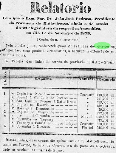
The same postal guide lists a Rio Grande post office in the Mato Grosso province under #835, which must have been the same agency listed in the Guia do Correio do Brasil of 1857. On the other hand, this office is not mentioned any more in the Imperial Mail Register (Tabella das Agencias do Correio do Império) of 1885. Since an extensive search on imperial maps has brought no results, it was necessary to start seeking in the regional press. And the mystery was unveiled through a provincial governor’s report on provincial mail lines of 1878:
O Liberal, November 28, 1878
The report says that mail route #3 was a terrestrial one, i.e. by foot or on horseback with a pack mule, exactly 792 km long, from the capital Cuyabá to “Rio-grande”. In the footnote we can read that the route was bi-monthly, and at the Rio Grande station a mail sack exchange “with the Goyaz mail” took place.
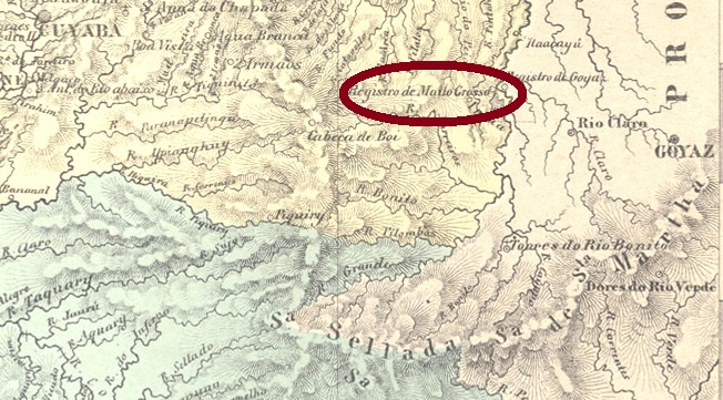
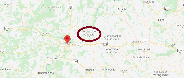
The inevitable conclusion is: the Rio Grande post office in Mato Grosso was situated on the main road or trail to Goiás, the capital of the neighbour province with the same name. And since there was mail exchange between both provinces at that spot, this should be located exactly on the provincial limits.
From now on the task was easy. Mato Grosso and Goiás are separated by the Araguaia River, which in its upper course is called … Rio Grande. A brief look in the Atlas do Império do Brasil of 1868 (see map above) reveals that there was a Registro (i.e. a tax collect station) for each province on each river bank, where one can find today the towns of Barra do Garças (Mato Grosso) and Aragarças (Goiás) nearby. If we consider that the old registros must also have been in the main road between Cuiabá and Goyás, we can strongly suppose that the Rio Grande post office operated in the Registro at the Mato Grosso side of the Araguaia River!
Next question: When the postal agency in Rio Grande was established? Since no press record has been found, we can only conjecture about a period between 1835 (when Cuiabá was made capital) and 1856 (redacting the Guia of 1857). And the post office was closed between 1880 and 1884.
No imperial cancel has been found so far. We are looking forward to seeing it!
Google Maps
Die Provinz Mato (damals Matto) Grosso im Kaiserreich Brasilien war viel größer als heute, da sie damals die heutigen Bundesstaaten Mato Grosso, Mato Grosso do Sul und Rondônia beinhaltete. In dieser riesigen Fläche gab es viele Flüsse, die Rio Grande hießen, aber die einzige Ortschaft mit diesem Namen fand man – ohne weitere Auskunft – im Guia Postal do Imperio von 1880:
Guia Postal do Imperio, 1880
Derselbe postalische Führer listet ein Postamt Rio Grande unter Nr. 835 in der Provinz Mato Grosso auf, das ebenfalls im Guia do Correio do Brasil von 1857 erwähnt worden war. Dafür ist diese Agentur im Verzeichnis der kaiserlichen Postämter (Tabella das Agencias do Correio do Império) von 1885 nicht mehr enthalten. Eine mühevolle Suche nach einer Ortschaft namens Rio Grande auf alten Landkarten brachte kein Ergebnis, so musste man die damalige Regionalpresse bemühen. Das Rätsel fand seine Lösung im Jahresbericht über Postrouten der Provinzregierung für 1878:
O LIberal, 28. November 1878
Dem Bericht nach war die Route Nr. 3 auf dem genaue 792 km langen Landweg – also zu Fuß oder auf Pferd, mit einem Packesel – zwischen der Hauptstadt Cuiabá und „Rio-grande“. Darunter liest man, dass diese Route 14-tägig stattfand, und an der Rio Grande-Station „die Postsäcke aus Goyaz empfangen“ wurden.
Es folgt daraus zwangsläufig, dass das Postamt Rio Grande der Provinz Mato Grosso auf dem Hauptweg zwischen Cuiabá und Goiás – der Hauptstadt der gleichnamigen Provinz – lag. Und weil dort der Postsack-Austausch zwischen beiden Provinzen stattfand, wäre die gemeinsame Provinzgrenze der ideale Ort dafür .
Von nun an ging es schneller. Mato Grosso und Goiás sind durch den Araguaia-Fluss getrennt, der in seinem Oberlauf… Rio Grande heißt! Ein kurzer Blick in den Atlas do Imperio do Brasil von 1868 entdeckte ein Registro (= Steuer-Zahlstelle) für die jeweilige Provinz am jeden Flussufer. In der Gegend, wo man auf einer heutigen Karte die Städte Barra do Garças (Mato Grosso) und Aragarças (Goiás) sieht. Wenn wir davon ausgehen, dass solche Registros auf dem Hauptweg zwischen den Hauptstädten hätten liegen müssen, können wir mit guter Sicherheit behaupten, dass das Postamt Rio Grande seinen Betrieb am Registro do Mato Grosso an der Westseite des Araguaia führte.
Nächste Frage: wann entstand dieses Postamt? Da bisher kein konkreter Hinweis darüber gefunden wurde, können wir nur über einen Zeitraum zwischen 1835 (als Cuiabá Provinzhauptstadt wurde) und 1856 (Redaktionsschluss für den Guia von 1857) spekulieren. Und das Amt wurde zwischen 1880 und 1884 geschlossen.
Noch kein Stempel aus der Kaiserzeit wurde gefunden. Wir freuen uns schon darauf!
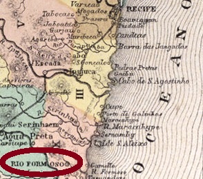
Carta Corographica da Provincia de Pernambuco, 1880
Print edition update of April 19, 2020
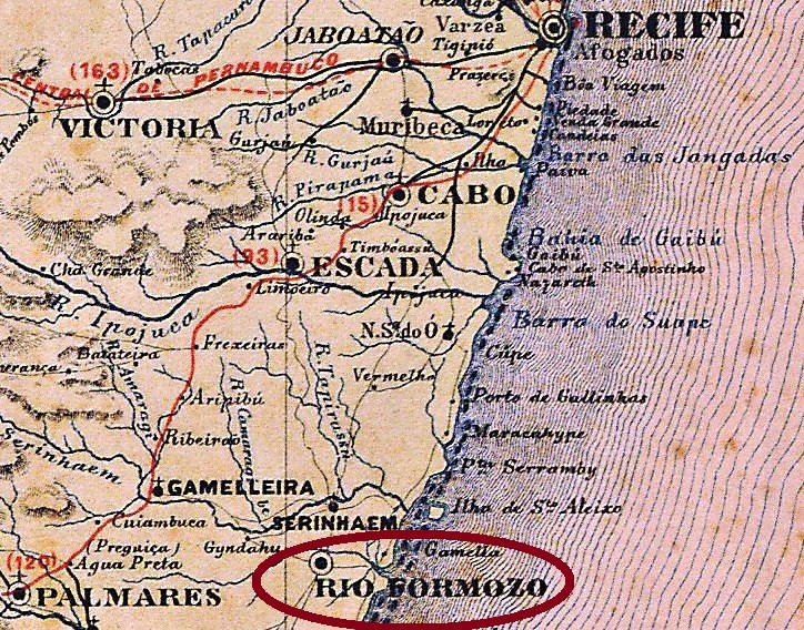
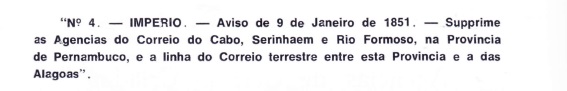
Rio Formoso (sometimes also written Formozo) was founded in May 1840 as a district of Recife (which even late in 19th century was often called Pernambuco, like the province), but acquired its emancipation as a municipality three years later and became a town in 1850. Situated ca. 90 km south of the capital on the road to Alagoas, Rio Formoso acquired some regional importance and was provided a post office already in March 1829, according to Nova Monteiro (Administrações e agencias postaes do Brasil Império 1798-1869, in Brasil Filatélico, Rio de Janeiro, 1934-5). However, this agency was closed in January 1851, as Aureo G. Santos tells us (Agências do correio criadas e suprimidas em 1851, 1855, 1856 e 1857, in Brasil Filatélico, Rio de Janeiro, 1977):
Aureo G. Santos, op.cit.
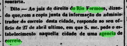
According to the Imperial Mail Register (Tabella das Agencias do Correio do Império) of 1885, the second creation of a post office in Rio Formoso took place in 1854, but this cannot be ratified, for still in May 1855 the lack of a mailing agency was complained:
Diario de Pernambuco, May 12, 1855
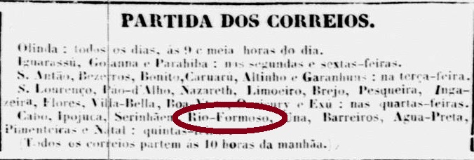
Nevertheless, the local post office must have reopened quite soon, for in May 1856 it appeared again in the mail courier timetable published in the Recife press:
Diario de Pernambuco, May 15, 1856
Three Rio Formoso cancels are listed in the Carimbologia (Q-R) print edition. Given that all of them were used in the eighties or later, there must be at least one more, which was surely applied in the first agency period (1829-1851). Moreover, the sole difference between RPE-0510a and RPE-0510b is the presence of a manuscript date in the latter. Thus, it would be reasonable to merge both types into RPE-0510b, leaving RPE-0510a free for the former type, when it eventually appears. And now for the cancel descriptions:
RPE-0510a remains now vacant. The new RPE-0510b (Coll. Claudio Coelho) is the old one: a French-type with the double circle, the inscription RIO FORMOSO above and the small star between parentheses below, but without dater in the centre. The date was written by hand or just absent (former RPE-0510a). Found in stamps used between ca. 1883 and 1890. RPE-0510c (image from the internet) might be already republican: a double circle with inscriptions RIO FORMOSO above and (PERNAMBUCO) below, still without date in the centre. Found on a stamp issued in 1897.
Atlas do Imperio do Brasil, 1868
Buchtext-Aktualisierung vom 19. April 2020
Rio Formoso (auch manchmal Formozo geschrieben) wurde in 1840 als Distrikt von Recife gegründet (die Pernambuco-Hauptstadt wurde ihrerseits bis spät im 19. Jahrhundert wie die gesamte Provinz genannt). Schon in 1843 stieg der Ort zu einer Villa auf, und in 1850 wurde aus Rio Formoso eine Stadt. Es liegt etwa 90 km südlich von Recife, auf dem Landweg nach Alagoas. Bedingt durch die wichtige Lage bekam der Ort sein Postamt bereits in 1829, laut Nova Monteiro (Administrações e agencias postaes do Brasil Império 1798-1869, in Brasil Filatélico, Rio de Janeiro, 1934-5). Dennoch wurde diese Agentur im Januar 1851 geschlossen, wie Aureo G. Santos berichtet (Agências do correio criadas e suprimidas em 1851, 1855, 1856 e 1857, in Brasil Filatélico, Rio de Janeiro, 1977):
Aureo G. Santos, op. cit.
Laut Verzeichnis der kaiserlichen Postämter (Tabella das Agencias do Correio do Império) von 1885 entstand das Postamt in Rio Formoso zum zweiten Mal in 1854, aber das kann nicht bestätigt werden, denn noch im Mai 1855 wurde das fehlende Amt vor Ort öffentlich beklagt:
Diario de Pernambuco, 12. Mai 1855
Dennoch dauerte es nicht mehr lange bis zur Wiedereröffnung, wie man aus dem Stafettenplan entnehmen kann, der in der Presse im Mai 1856 veröffentlicht wurde:
Diario de Pernambuco, 15. Mai 1856
Drei Stempel aus Rio Formoso sind in der gedruckten Ausgabe der Carimbologia (Q-R) zu sehen. Da sie alle in den achtziger Jahren des 19. Jahrhunderts oder später verwendet wurden, muss es aber mindestens noch einen zusätzlichen Stempel geben, der in der Frühzeit des Postamts (1829-1851) verwendet wurde. Darüber hinaus besteht der einzige Unterschied zwischen RPE-0510a und RPE-0510b aus der handgeschriebenen Datumsangabe auf Letzterem. Darum wäre es sinnvoller, beide Typen unter RPE-0510b zusammen zu legen, und RPE-0510a frei für den (hoffentlich irgendwann zu erscheinenden) früheren Stempel. Nun aber zu den Beschreibungen:
RPE-0510a ist jetzt vakant. Der neue RPE-0510b (Samml. Claudio Coelho) ist der alte: ein „Französischer-Typ“ mit dem Doppelkreis, der Inschrift RIO FORMOSO oben und dem kleinen Stern zwischen Klammern unten, aber ohne Datum in der Mitte. Dieses wurde per Hand geschrieben, oder fehlte einfach (alte RPE-0510a). Gefunden auf Marken, die zwischen ca. 1883 und 1890 gebraucht wurden. RPE-0510c (Abbildung aus dem Internet) könnte bereits aus der Zeit der Republik sein: ein Doppelkreis mit der Inschrift RIO FORMOSO oben und (PERNAMBUCO) unten, immer noch ohne Datum in der Mitte. Gefunden auf einer Marke, die in 1897 ausgegeben wurde.
Other names: Santo Antonio do Rio Feio, Bela Vista (1885), Porangaba (1919)
See also: Bela Vista (R. Koester: Carimbologia IV)
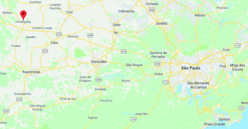
Rio Feio means Ugly River, so it is no wonder that other names followed for this locality. Santo Antonio do Rio Feio was founded in April 1880 as a district of the municipality of Tatuhy (now written Tatuí), situated about 170 km west from São Paulo. It changed the toponym for the first time in February 1885 to Bela Vista (= Beautiful Sight, probably from the river perspective), and for the second time in November 1919 to Porangaba, which in the tupi-guarani language means “The Beauty”. Since December 1927 has Porangaba an own municipality.
An Indian legend calls porangaba all medicine plants capable to make humans more beautiful, such as the Cordia salicifolia, also known as chá-de-bugre (= Indian Tea) or …porangaba (see above).
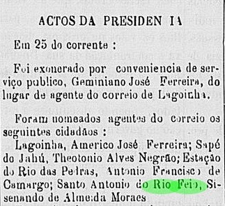
According to the Imperial Mail Register (Tabella das Agencias do Correio do Império) of 1885, a post office was created in Rio Feio in 1881, whose first clerk was soon announced in the press:
Correio Paulistano, May 28, 1881
No imperial cancel from Rio Feio was found to date. It must be rare, given the short time until the toponym was changed.
Google Maps
Andere Namen: Santo Antonio do Rio Feio, Bela Vista (1885), Porangaba (1919)
Siehe auch: Bela Vista (R. Koester: Carimbologia IV)
Rio Feio bedeutet Hässlicher Fluss, so wundert es nicht, dass dieser Ortschaft weitere Namen im Lauf der Zeit verpasst wurden. Santo Antonio do Rio Feio wurde im April 1880 als ein Distrikt des Município von Tatuhy (heute Tatuí geschrieben) gegründet, etwa 170 km westlich von São Paulo entfernt. Der Ortsname wechselte erstmals im Februar 1885 zu Bela Vista (= Schöne Aussicht, womöglich aus der Flussperspektive) und zum zweiten Mal im November 1919 zu Porangaba, was in der tupi-guarani Indianersprache soviel wie „Die Schönheit“ bedeutet. Seit 1927 ist Porangaba als Município unabhängig.
Eine Indianerlegende nennt porangaba alle Heilpflanzen, die die Menschen schöner machen können, so wie die Cordia salicifolia, auch chá-de-bugre (= Indianertee) genannt, oder auch … porangaba (siehe oben)
Laut Verzeichnis der kaiserlichen Postämter (Tabella das Agencias do Correio do Império) von 1885 entstand das Postamt in Rio Feio in 1881, und dessen erster Angestellter war bald in der regionalen Presse bekannt gegeben:
Correio Paulistano, 28 Mai 1881
Bisher wurde kein Stempel der Kaiserzeit aus Rio Feio gefunden. Der muss auch selten sein, da der Ortsname bald wechselte.
Carta da Republica dos Estados Unidos do Brazil, 1892
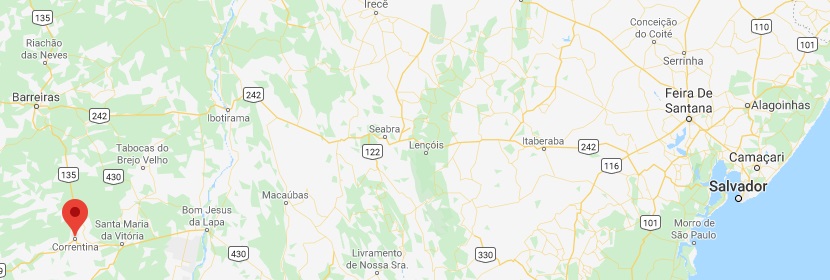
The Freguesia de Nossa Senhora da Glória do Rio das Egoas (later spelled Eguas) was founded in 1806 by adventurers looking for gold and precious stones in the municipality of Carinhanha in the far west of Bahia, over 900 km away from Salvador. The Rio das Éguas (= Mares River) is also called Correntinha (= Little Stream), for it flows into the Corrente River, an affluent on the left bank of the São Francisco River.
Rio das Egoas became a Villa with own municipality in 1866, but due to economic and administrative weakness it lost the autonomy twice: in 1880 and 1888. In 1880 it was even renamed to Santa Maria do Rio das Egoas as a freguesia of the new municipality of Porto de Santa Maria da Victoria. It acquired the definitive emancipation in 1891 through the municipality of Correntina, this name being a tribute to the local river.
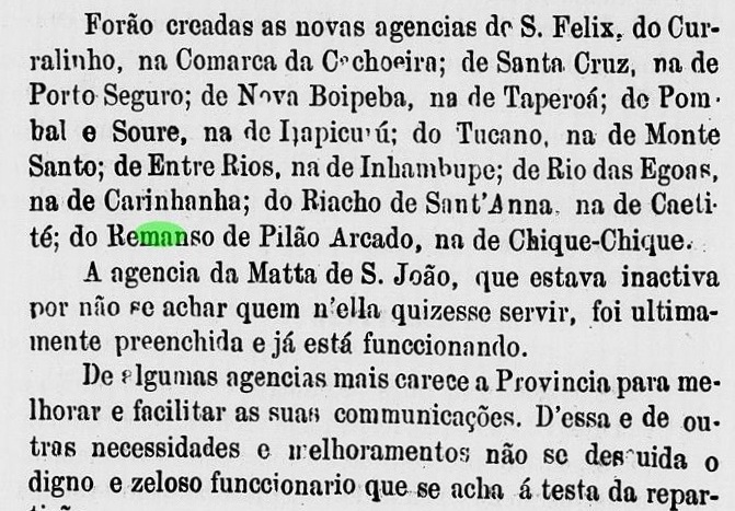
There are two dates for the creation of the post office. The Imperial Mail Register (Tabella das Agencias do Correio do Império) of 1885 lists a post office in Rio das Eguas in the Bahia province, which was created in 1870, while the Bahia Government Counsel Report for 1876 tells about a new agency in Rio das Egoas:
Relatorio do Conselho Interino do Governo da Bahia, 1876
Either is the year indication 1870 in the Mail Register of 1885 a misprint, or the office was later closed and reopened in ca. 1876.
Two imperial cancels from Rio das Eguas have come into light: RBA-0605a (Coll. José A. Junges) was found on a D. Pedro issue of 1876. It has a double circle with the inscription RIO DAS EGUAS above and an ornament between circles below, which is unfortunately incomplete in the sole existent copy. No date in the centre. RBA-0605b (Coll. José A. Junges) was applied on a D. Pedro issue of 1885. Here the double circle has the same inscription above, with slightly different letters, but the ornament below has disappeared, and there is a date within the inner circle.
Google Maps
Die Freguesia de Nossa Senhora da Glória do Rio das Egoas (später Eguas geschrieben) wurde in 1806 durch Abenteurer auf der Suche nach Gold und Edelsteinen im Verwaltungsgebiet von Carinhanha gegründet, über 900 km westlich von Salvador da Bahia. Der Rio das Éguas (= Fluss der Stuten) nennt sich auch Correntinha (= Kleiner Strom) und fließt in den Corrente, einen Zufluss am linken Ufer des São Francisco.
Rio das Egoas wurde erstmals eine Villa mit Verwaltungsautonomie in 1866, aber bedingt durch wirtschaftliche und administrative Schwäche verlor sie gegen Ende des Kaiserreichs gleich zweimal ihre Unabhängigkeit, in 1880 und in 1888. In 1880 wurde sie unter dem Namen Santa Maria do Rio das Egoas eine freguesia des neu gegründeten Município von Porto de Santa Maria da Victoria. Erst in 1891, schon in der Republik, kam die endgültige Emanzipierung, als aus Rio das Éguas der Município von Correntina wurde, in Anlehnung am Correntinha-Fluss.
Es sind zwei Daten für die Entstehung des Postamts überliefert. Das Verzeichnis der kaiserlichen Postämter (Tabella das Agencias do Correio do Império) von 1885 listet die Agentur Rio das Eguas mit Gründungdatum 1870, während der Bericht der Interimsverwaltung Bahias ein neues Postamt für 1876 nennt:
Relatorio do Conselho Interino do Governo da Bahia, 1876
Entweder ist die Angabe 1870 im Verzeichnis von 1885 ein Druckfehler oder wurde die Agentur Rio das Egoas zwischendurch geschlossen.
Zwei Abstempelungen der Kaiserzeit sind aufgetaucht: RBA-0605a (Samml. José A. Junges) wurde auf einer D. Pedro-Ausgabe von 1876 gefunden. Es hat einen Doppelkreis mit der Inschrift RIO DAS EGUAS oben und eine Verzierung zwischen den Kreisen unten, die leider im einzigen Exemplar unvollständig ist. Kein Datum im Innenkreis. RBA-0605b (Samml. José A. Junges) wurde auf eine D. Pedro-Ausgabe von 1885 aufgebracht. Hier trägt der Doppelkreis die gleiche Inschrift (mit leicht veränderten Buchstaben) oben, das Ornament unten ist verschwunden, und nun gibt es ein Datum im Innenkreis.
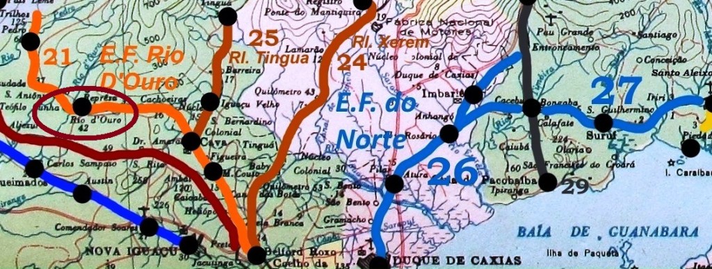
Rio D’Ouro was a train station of the Estrada de Ferro Rio de Ouro railway (São Pedro branch) now in the municipality of Nova Iguaçu, situated about 55 km northwest from Rio de Janeiro. Another station with similar name was Rio Dourado, which was built later by the Estrada de Ferro de Maricá in the actual municipality of Casimiro de Abreu (RJ). The post office here was created in the republic.
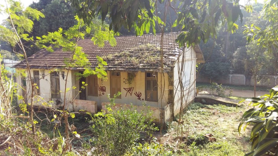
According to Ralph Giesbrecht (estacoesferroviarias.com.br) the station was ready to operate in January 1883, at that time in the municipality of Iguassu. The railway control passed to the Estrada de Ferro Central do Brasil in 1928 and the line operated until 1970. Now the tracks are removed and the station house seems abandoned (see picture below).
Paulo Novaes (agenciaspostais.com.br) tells us the post office of the Rio D’Ouro train station was created in December 1888. No postmarks from the Empire have appeared to date.
In 2017 (Allofs Batista – estacoesferroviarias.com.br)
Anderer Name: Estação Rio do Ouro
Rio D’Ouro war ein Bahnhof der Gesellschaft Estrada de Ferro Rio do Ouro (Abzweigung São Pedro), der heute im Município von Nova Iguaçu liegt, etwa 55 km nordwestlich von Rio de Janeiro. Ein anderer Bahnhof mit ähnlichem Name war Rio Dourado, der später von der Gesellschaft Estrada de Ferro de Maricá im heutigen Município von Casimiro de Abreu (RJ) gebaut wurde. Das Postamt dazu wurde erst in der Republik errichtet.
Laut Ralph Giesbrecht (estacoesferroviarias.com.br) wurde der Bahnhof im Januar 1883 eingeweiht, damals hieß der Município noch Iguassu. In 1928 ging die Bahngesellschaft in Besitz der Estrada de Ferro Central do Brasil über, und die Strecke blieb bis 1970 in Betrieb. Heute sind die Schienen ausgerissen, und das Bahngebäude scheint verwahrlost (s. Abbildung oben).
Paulo Novaes (agenciaspostais.com.br) nennt den Dezember 1888 als Entstehungsdatum fürs Postamt dieses Bahnhofs. Bisher sind keine Abstempelungen aus der Kaiserzeit überliefert.
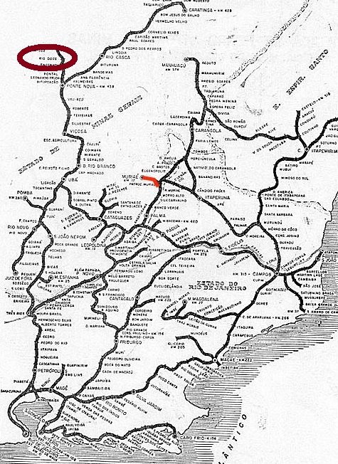
According to Paula Sobrinho (História Postal de Minas Gerais, Belo Horizonte, 1997), there were two postal agencies named Rio Doce in the Minas Gerais province during the Brazilian Empire. The elder of both was the former Freguesia de Santo Antonio do Bom Successo do Descoberto do Pessanha, which was elevated to the Villa do Rio Doce in 1875, but six years later it changed the toponym again, becoming a Cidade de Suassuhy. Paula Sobrinho states that the local post office and the Villa were created on the same day (October 25, 1875), a very unusual procedure. There follows that, even considering that seals were not quite ready at the mailing operation start and finish, all cancellations from this Villa would date approximately between 1875 and 1882. However, no Rio Novo cancellation from that period has come into light until now.
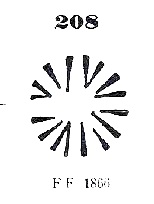
On the other hand, Reinhold Koester (Carimbologia XXXI) writes October 15, 1875 for the creation date of the post office (i.e. before Pessanha has turned to Rio Doce) and presents a Pessanha manuscript cancel on a D. Pedro emission of 1876. He also shows a mute cancellation which might be identical to Paulo Ayres #208, asserting that the respective letter was mailed in Pessanha in 1879:
Paulo Ayres #208
These two Koester examples prove that the old name Pessanha survived on letters and cancels after the toponymic change, and might indicate that the new name Rio Doce was locally not very popular.
Since all known Rio Doce cancels from Minas Gerais were applied between 1887 and 1890, these must refer to the second agency, a train station post office at the Estrada de Ferro Leopoldina railroad, Dom Silvério Branch, in the municipality of Mariana. According to Ralph Giesbrecht (estacoesferroviarias.com.br), the train station was installed on December 6, 1886, and Paula Sobrinho (op. cit.) tells us the post office was created in April 1887.
The only cancel type found so far, RMG-2135a (Coll. José A. Junges), shows a double circle with inscriptions RIO-DOCE above and (MINAS) below, with dates (between 1887 and 1890, as written before) in the inner circle.
riodocenanaet.com
Laut Paula Sobrinho (História Postal de Minas Gerais, Belo Horizonte, 1997) gab es zwei Postämter in der Provinz Minas Gerais im Kaiserreich Brasilien, die Rio Doce hießen. Das älteste davon war die ehemalige Freguesia de Santo Antonio do Bom Successo do Descoberto do Pessanha, die in 1875 zur Villa do Rio Doce aufstieg, aber schon sechs Jahre später den Ortsnamen wieder gewechselt hat, zu Cidade de Suassuhy. Paula Sobrinho schreibt, sowohl Villa als auch Postamt seien am selben Tag (25. Oktober 1875) entstanden, eine sehr unübliche Konstellation. Das würde bedeuten, dass auch wenn die Poststempel nicht ganz pünktlich zum Betriebsbeginn einsatzbereit gewesen wären, alle Abstempelungen unter diesem neuen Ortsnamen wären etwa zwischen 1875 und 1882 datiert. Aber aus diesem Zeitraum ist bisher kein einziger Rio Doce-Stempel aufgetaucht.
Dafür schreibt Reinhold Koester (Carimbologia XXXI), dass das dortige Postamt bereits am 15. Oktober entstanden ist (also noch bevor aus Pessanha Rio Doce wurde) und präsentiert eine handschriftliche Entwertung mit Pessanha auf einer D. Pedro-Ausgabe aus 1876. Koester zeigt auch einen stummen Stempel, der mit Paulo Ayres Nr. 208 identisch sein könnte, und behauptet, der dazu gehörende Brief wurde in Pessanha in 1879 versendet:
Paulo Ayres Nr. 208
Diese beiden Beispiele belegen, dass der alte Ortsname Pessanha den Namenswechsel in Briefen und postalischen Entwertungen überlebt hat, und lassen die Vermutung zu, dass der neue Name Rio Doce bei der Bevölkerung nicht sehr beliebt gewesen war.
Da alle bekannten Rio Doce-Stempel aus Minas Gerais zwischen 1887 und 1890 datiert sind, müssen sie dem zweiten Postamt zugeordnet werden. Dieses war ein Bahnhofspostamt der Estrada de Ferro Leopodina, Abzweigung Dom Silvério, im Município von Mariana. Laut Ralph Giesbrecht (estacoesferroviarias.com.br) wurde der Bahnhof am 6. Dezember 1886 installiert, das Postamt dazu entstand im April 1887 (Paula Sobrinho, op. cit.).
Die einzige bisher gefundene Abstempelung, RMG-2135a (Samml. José A. Junges), zeigt einen Doppelkreis mit der Inschrift RIO-DOCE oben und (MINAS) unten, und die Daten, wie vorher genannt, sind zwischen 1887 und 1890 im Innenkreis.
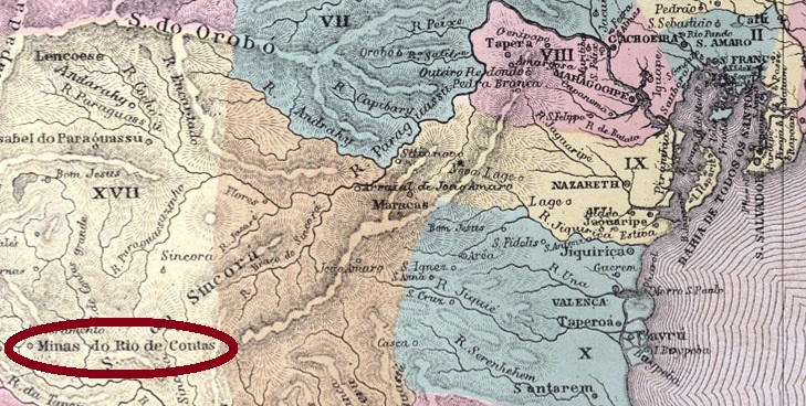
Other names: Santo Antônio do Mato Grosso, Minas do Rio de Contas
This historical town, splendidly situated in the Chapada Diamantina in Bahia, has newly experienced a revival for its tourist attractions. At the beginning, some time in 17th century, it was called Pouso dos Crioulos, a hideout for fugitive slaves on the miners’ trail between Mato Grosso and Salvador. The discovery of gold mines in the region around 1710 drew many seekers from Brazil and abroad, and from then on population has rapidly increased. In 1715 the chapel of Nossa Senhora do Livramento (actually Livramento de Nossa Senhora) was built 12 km south. Three years later, Pouso dos Crioulos was renamed Santo Antonio do Mato Grosso, and in November 1723, both settlements were united into the Villa de Nossa Senhora do Livramento das Minas do Rio de Contas. A main connecting road to Jacobina and Salvador was built in 1725, and one year later a gold smeltery was installed.
The prosperity period ended around 1800, when mines were exhausted and miners had to decide between go further and stay in the village, changing their livelihood. In 1840, the toponym was simplified to Villa de Minas do Rio de Contas, which was elevated to a town in 1885. Finally, in June 1931 the municipality was renamed Rio de Contas.
According to Nova Monteiro, the post office was created in May 1832. The first cancel, RBA-0805a, was presented by Paulo Ayres in his supplement of 1942, but since that image was not correct, this source originates from Henrique B. Ferreira (Catálogo Ilustrado dos carimbos sobre os olhos-de-boi, 4a. ed., Porto Alegre, 2017), under Nr. R5. It occurs in black, brown and red-brown, with dates probably between 1832 and 1844:
RBA-0805a, HBF #R5
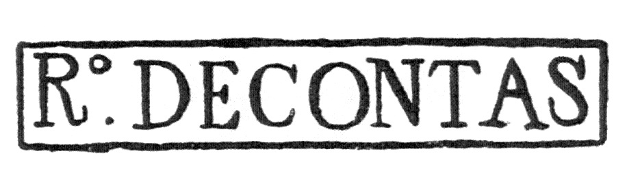
The following cancel, RBA-0805b, was presented by Paulo Ayres (1937) under #1602. However, Henrique B. Ferreira (op.cit., #R6) notes a missing dot in the diamond between CONTAS and MINAS below. It has dates between ca. 1843 and ca.1876, occurring in black, brown, red and green:
RBA-0805b, P.Ayres #1602, HBF #R6
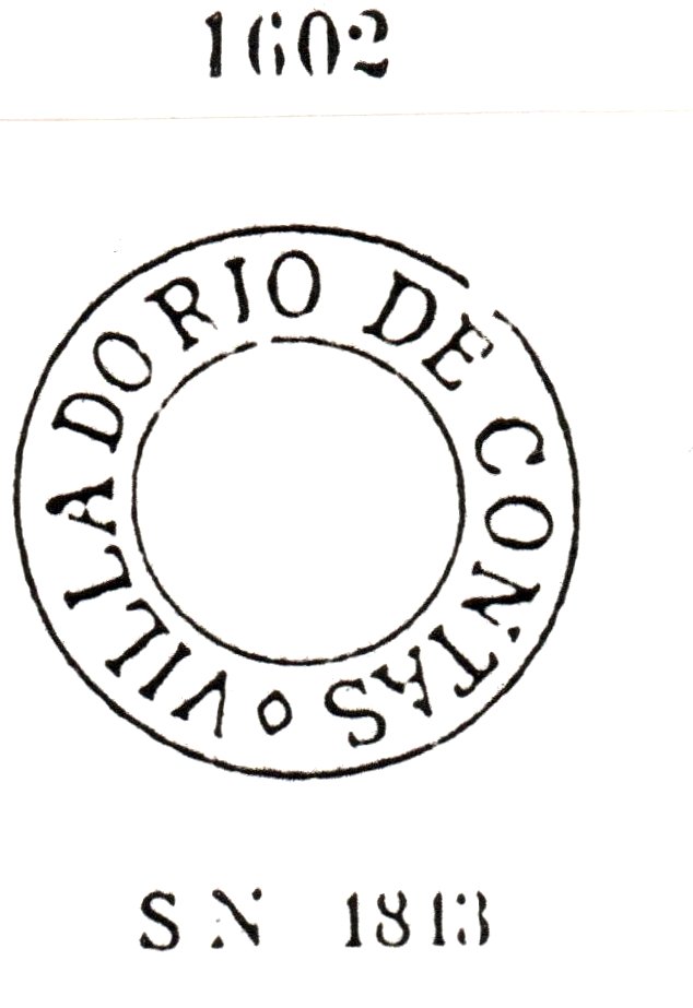
Finally, RBA-0805c (Coll. Karlheinz Wittig) has a double circle with inscription RIO DE CONTAS above and the date in the inner circle. Exemplars found with postmarks between 1876 and 1888.
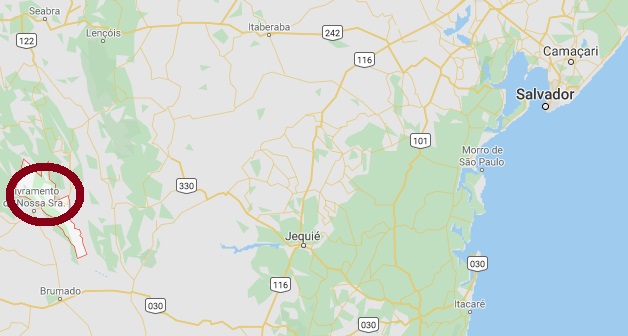
Google Maps
Andere Namen: Santo Antônio do Mato Grosso, Minas do Rio de Contas
Dieser historische Ort, reizvoll in der Chapada Diamantina im Bundesstaat Bahia gelegen, wurde in letzter Zeit wieder durch seine touristischen Vorzüge bekannt. Am Anfang, irgendwann im 17. Jahrhundert, hieß er Pouso dos Crioulos und war nicht viel mehr als ein Versteck für geflüchtete Sklaven auf der Strecke zwischen Mato Grosso und Salvador, von Goldsuchern und anderer Abenteurern als Übernachtungsort benutzt.
Die Entdeckung von Goldvorkommen um 1710 änderte die Geschichte des Orts radikal. Aus dem In- und Ausland kamen Goldssucher, die Bevölkerungszahl stieg schnell an, und schon in 1715 wurde 12 km südlich die Kapelle Nossa Senhora do Livramento (heute Livramento de Nossa Senhora) errichtet. Drei Jahre später wurde Pouso dos Crioulos in Santo Antonio do Mato Grosso umbenannt, und im November 1723 wurden beide Siedlungen vereint, unter der feierlichen Bezeichnung Villa de Nossa Senhora do Livramento das Minas do Rio de Contas. Dazu kamen eine Hauptstrasse nach Salvador über Jacobina in 1725 und ein Jahr später die Hütte für den Goldschmelz.
Ab 1800 ging es mit dem Wohlstand der Gemeinde bergab. Die Goldvorkommen waren praktisch ausgeschöpft und die Sucher mussten entscheiden, ob sie weiter ziehen oder im Ort bleiben sollten, dann aber in anderen Berufen. In 1840 wurde der Ortsname als Villa de Minas do Rio de Contas vereinfacht, und in 1885 bekam der Ort den Stadtstatus. Schließlich hieß der Município ab 1931 Rio de Contas.
Das Postamt wurde laut Nova Monteiro im Mai 1832 errichtet. Der erste Stempel, RBA-0805a, wurde durch Paulo Ayres in seinem Supplement von 1942 vorgestellt. Da aber diese Abbildung fehlerhaft ist, zeigen wir hier das von Henrique B. Ferreira (Catálogo Ilustrado dos carimbos sobre os olhos-de-boi, 4a. ed., Porto Alegre, 2017) veröffentlichte Bild, unter Nr. R5. Den Stempel gibt es in schwarz, braun und rotbraun, mit vermuteten Daten zwischen 1832 und 1844:
RBA-0805a, HBF Nr. R5
Der nächste Stempel, RBA-0805b, wurde von Paulo Ayres (1937) unter Nr. 1602 gezeigt. Dennoch hat Henrique B. Ferreira (op.cit., Nr. R6) einen fehlenden Punkt in der Raute zwischen CONTAS und MINAS (unten) festgestellt. Er hat Daten zwischen ca. 1843 und ca.1876 und kommt in schwarz, braun, rot und grün vor:
RBA-0805b, P.A. 1602, HBF Nr. R6
Der dritte Stempel, RBA-0805c (Samml. Karlheinz Wittig) hat einen Doppelkreis mit der Inschrift RIO DE CONTAS oben und dem Datum im Innenkreis. Die gefundenen Exemplare haben Stempeldaten zwischen 1876 und 1888.