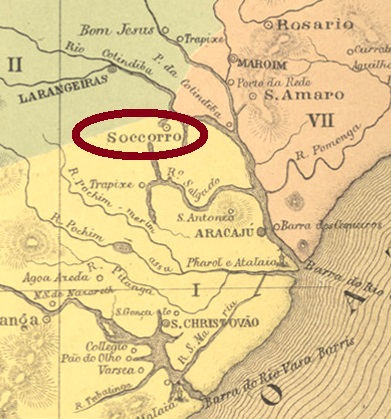
Other names: Cotiguiba, Nossa Senhora do Socorro (1954)
The district of Nossa Senhora do Soccorro de Cotiguiba was created in July 1864, located only 15 km northwest of the provincial capital, Aracaju. In March 1868 came the administrative autonomy as a vila. Then the place name changed first to Cotiguiba in December 1943, and then back to the still actual Nossa Senhora do Socorro in February 1854.
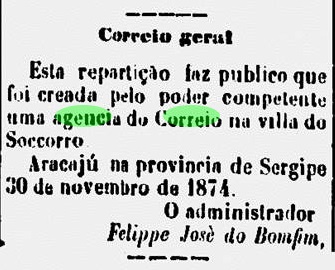
The local post office was created in November 1874, as reported in the regional press:
Jornal do Aracaju, 02.12.1874
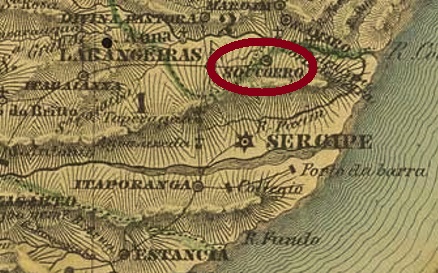
So far, no postmark of the imperial period could be surely assigned to this place.
Villiers de l’Ile Adam: Carta (…) das Provincias de Pernambuco, Alagoas e Sergipe, 1848
Andere Namen: Cotiguiba, Nossa Senhora do Socorro (1954)
Der Distrikt von Nossa Senhora do Soccorro de Cotiguiba wurde im Juli 1864 ins Leben gerufen und lag nur 15 km nordwestlich der Provinzhauptstadt Aracaju. Im März 1868 kam die Verwaltungsautonomie als Vila. Dann wechselte der Ortsname im Dezember 1943 erstmals zu Cotiguiba, und dann im Februar 1854 wieder zurück zum aktualen Nossa Senhora do Socorro.
Das örtliche Postamt entstand im November 1874, wie die Regionalpresse berichtete:
Jornal do Aracaju, 02.12.1874
Bisher konnte kein Poststempel der Kaiserzeit diesem Ort mit Sicherheit zugeordnet werden.
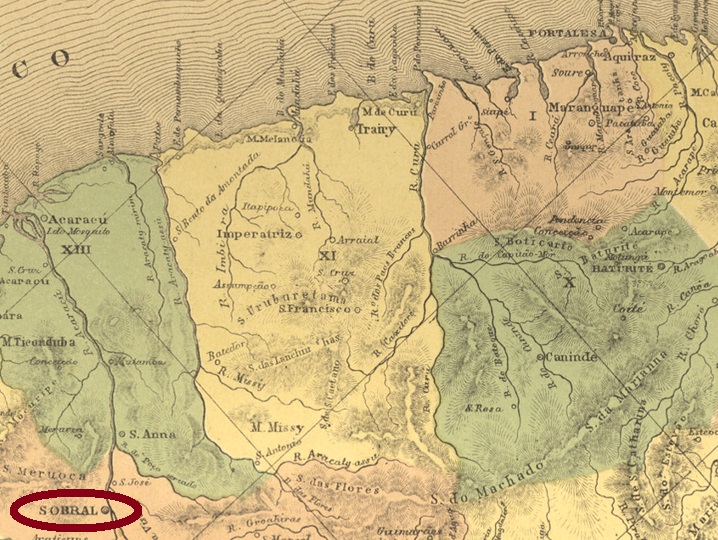
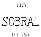
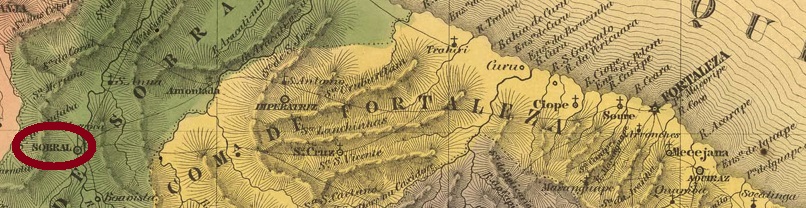
Sobral was a freguesia of Fortaleza from August 1857, located on the west bank of the Acaraú River, over 250 km west of the future provincial capital. Already in June 1766, the place rose to the status of a villa, then in January 1841 to a town, called Januária do Acaraú. This name certainly did not go down well, because already in October 1842 the old place name returned, and so it has remained to this day.
The local post office was wrestled into being at least twice. So far it has not been possible to find out when it first took place, but it was certainly before 1843, because there is at least one pre-phila postmark from Sobral: SCE-0325a, already presented by Paulo Ayres in Catálogo de Carimbos Brasil-Império (S. Paulo, 1937, 1942) under no. 1177:
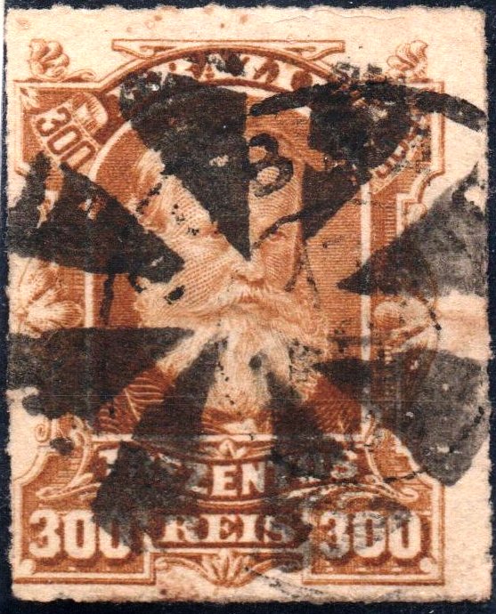
SCE-0325a (P.A.1177, RHM P-CE-03), before 1843-after 1844
According to Nova Monteiro (Administrações e Agencias Postaes do Brasil Imperio, in Brasil Filatelico/RJ, 1934-5; Reprint SPP 1994-1999), the second poster opening would have taken place in 1857. However, this date is questionable, as the postal report for 1859 lists the Sobral agency as older than 1854. Be that as it may, the next postmark SCE-0325c (image from the Internet), a double circle with the inscription SOBRAL at the top, was found only with dates between 1889 and 1904. So there may have been a previously unknown postmark in circulation in between.
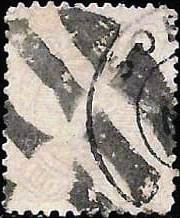
Two mute cancellations from Sobral were still to be found. Once on a D. Pedro issue from 1877:
1877ff (Coll. José A. Junges)
Then also on a D. Pedro issue from 1883:
1883ff (Coll. José L. Fevereiro)Villiers de l’Ile Adam: Carta (…) da Provincia do Ceara, 1849
Anderer Name: Januária de Acaraú (1841-1842)
Sobral war ab August 1857 eine Freguesia von Fortaleza, die am Westufer des Flusses Acaraú lag, über 250 km westlich der künftigen Provinzhauptstadt. Bereits im Juni 1766 stieg der Ort zur Villa auf, dann im Januar 1841 zu einer Stadt, genannt Januária do Acaraú. Dieser Name kam bestimmt nicht gut an, denn bereits im Oktober 1842 kehrte der alte Ortsname zurück, und so ist es bis heute geblieben.
Das örtliche Postamt wurde mindestens zweimal ins Leben gerungen. Bisher war es nicht möglich herauszufinden, wann es erstmals stattfand, aber sicher war es vor 1843. Denn es gibt zumindest einen Vorphila-Poststempel aus Sobral: SCE-0325a, der bereits durch Paulo Ayres in Catálogo de Carimbos Brasil-Império (S. Paulo, 1937, 1942) unter Nr. 1177 vorgesetellt wurde:
SCE-0325a (P.A.1177, RHM P-CE-03), vor 1843-nach 1844
Die zweite Posteröffnung hätte laut Nova Monteiro (Administrações e Agencias Postaes do Brasil Imperio, in Brasil Filatelico/RJ, 1934-5; Reprint SPP 1994-1999) 1857 stattgefunden. Allerdings ist dieses Datum fraglich, denn im Postbericht für 1859 wird die Agentur Sobral als älter als 1854 aufgelistet. Wie es dem auch sei, der nächste Poststempel SCE-0325c (Abb. aus dem Internet), eine Doppelkreis mit der Inschrift SOBRAL oben, wurde erst mit Daten zwischen 1889 und 1904 gefunden. Es dürfte also noch einen bisher unbekannten Poststempel dazwischen im Umlauf gewesen sein.
Zwei stumme Entwertungen aus Sobral waren noch zu finden. Einmal auf einer D. Pedro Ausgabe von 1877:
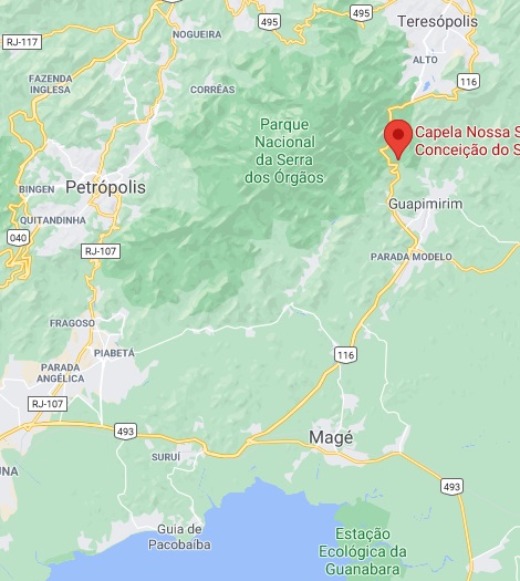
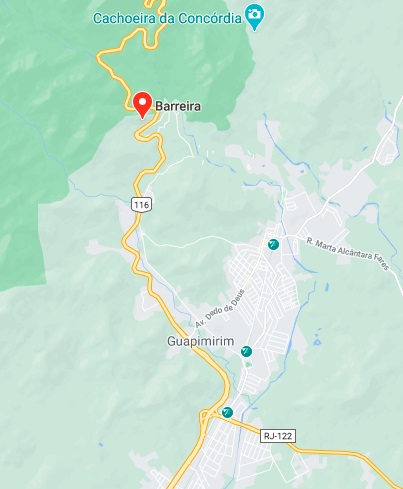
See also Barreira do Soberbo (R. Koester: Carimbologia III).
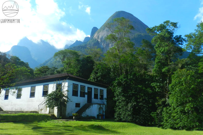
Soberbo is a small river called Guapimirim in its lower course. On the upper course, probably before the 18th century, a barreira (a toll station) was built, where later the Fazenda Barreira was established, whereas today the Museum Von Martius is located, in memory of the German naturalist Friedrich Phillip von Martius (1794-1868), who 200 years ago undertook an expedition through Brazil.
The Von Martius Museum (Photo: Guapimirimtur)
A settlement was established there as early as 1755, which belonged to the Magé county, over 80 km north of the capital Rio de Janeiro. Since December 1990, Barreira has been a district in the Município of Guapimirim.
As Paulo Novaes writes in agenciaspostais.com.br, there was a post office there since July 1877, but it was closed in April 1891. The imperial postmark is SRJ-0150a (Coll. José A. Junges): a double circle, whose the only existing example (on a number issue from 1888) unfortunately shows just the upper half with the inscription SOBERBO.
Google Maps
Siehe auch Barreira do Soberbo (R. Koester: Carimbologia III)
Soberbo ist ein kleiner Fluss, der am Unterlauf Guapimirim genannt wird. Am Oberlauf wurde wohl noch vor dem 18. Jahrhundert eine Barreira, eine Mautstelle, an der später eine Fazenda Barreira entstand, dort wo sich heute das Museum Von Martius befindet, im Andenken an den Erlanger Naturforscher Friedrich Phillip von Martius (1794-1868), der vor 200 Jahren eine Expedition durch Brasilien unternommen hat.
Das Museum Von Martius (Foto: Guapimirimtur)
Dort entstand bereits 1755 eine Siedlung, die zur Gemarkung Magé gehörte und über 80 km nördlich der Hauptstadt Rio de Janeiro entfernt lag. Seit Dezember 1990 ist Barreira ein Ortsteil im Município von Guapimirim.
Wie Paulo Novaes im agenciaspostais.com.br schreibt, gab es dort ein Postamt seit Juli 1877, der allerdings im April 1891 geschlossen wurde. Der kaiserliche Poststempel ist SRJ-0150a (Samml. José A. Junges): Ein Doppelkreis, dessen bisher einzig vorhandenes Exemplar (auf einer Ziffernausgabe von 1888) leider nur die obere Hälfte mit der Inschrift SOBERBO zeigt.
Carta da Republica dos Estados Unidos do Brazil, 1892
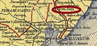
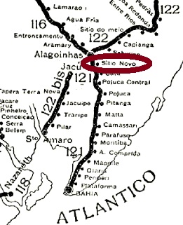
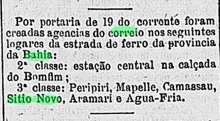
The Sítio Novo (New Estate) station was inaugurated in February 1863 by the E.F. da Bahia ao São Francisco railway company and was located on the main line near Catú, 100 km north of the provincial capital Salvador da Bahia. In 1911 the railway line became the property of the company Chemins de Fer Féderaux du l’Est Brésilien, in 1935 it became part of the Viação Férrea Leste Brasileiro and from 1975 until its closure in 1996 it belonged to Rede Ferroviária Federal S.A. (estacoesferroviarias.com.br)
The station post office was created in April 1881, as reported by the Rio press:
Gazeta de Noticias/RJ, 21/04/1881
A station postmark was found: SBA-0715a (Coll. Márcio Protzner) is a double circle with the inscriptions SITIO NOVO above and (BAHIA) below. Both copies found so far bear dates from the Republic (1890-1891) inside.
Instituto Brasileiro de Geografia e Estatística
Der Bahnhof Sítio Novo (Neuer Landsitz) wurde im Februar 1863 von der E.F. da Bahia ao São Francisco eingeweiht und lag auf der Hauptlinie bei Catú, 100 km nördlich der Provinzhauptstadt Salvador da Bahia entfernt. 1911 ging die Bahnlinie in Besitz der Gesellschaft Chemins de Fer Féderaux du l’Est Brésilien, 1935 zur Viação Férrea Leste Brasileiro und von 1975 bis zur Stilllegung 1996 gehörte sie der Rede Ferroviária Federal S.A. (estacoesferroviarias.com.br)
Das Bahnhofspostamt entstand im April 1881, wie die Presse aus Rio berichtet:
Gazeta de Noticias/RJ, 21.04.1881
Ein Bahnhofspoststempel wurde gefunden: SBA-0715a (Samml. Márcio Protzner) ist ein Doppelkreis mit den Inschriften SITIO NOVO oben und (BAHIA) unten. Beide bisher gefundene Exemplare tragen darinnen Daten aus der Republik (1890-1891).
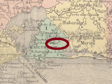
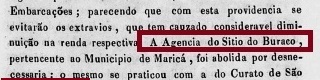
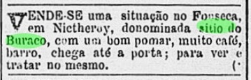
Sítio do Buraco (“Country Seat of the Hole”) is another enigma among the imperial post offices in Brazil. It is not known exactly where it was located, neither exactly when it opened, nor exactly when it closed. All we know is that such a post office existed until about 1832, as a report from the Imperial Ministry tells us:
Relatório do Ministério do Império, 1833
The report tells that this place was near Maricá, and that this agency was “unnecessary”, i.e. hardly or not used at all. Later press reports from Rio connect the locality with the Município of São Gonçalo. Since this municipality did not separate from Maricá but from Niterói in 1890, we can conclude that Sítio do Buraco was located in the present-day border area between Maricá and São Gonçalo. According to a report from 1879, Sítio do Buraco was a country estate near Fonseca in the municipality of Niterói:
Gazeta de Noticias/RJ, 29 January 1879
As one might expect, no local postmark was found. If there is one, it must be a great rarity.
Bellegard-Niemeyer: Carta Corographica da Provincia do Rio de Janeiro, 1867
Sítio do Buraco (“Landsitz des Lochs”) ist ein weiterer Rätsel unter den kaiserlichen Postämtern in Brasilien. Man weiß nicht, wo es genau lag, wann es genau eröffnete und auch nicht genau, wann es geschlossen wurde. Man weiß nur, dass so ein Postamt bis ca. 1832 gegeben hat, wie uns ein Bericht des kaiserlichen Ministeriums verrät:
Relatório do Ministério do Império, 1833
Aus der Meldung geht hervor, dass dieser Ort bei Maricá lag, und dass diese Agentur „unnötig“ war, sprich kaum oder gar nicht benutzt. Spätere Pressemeldungen aus Rio bringen die Ortschaft in Verbindung mit dem Município von São Gonçalo. Da diese Gemeinde 1890 nicht von Maricá, sondern von Niterói ausgegliedert wurde, können wir daraus folgen, dass Sítio do Buraco im heutigen Grenzgebiet zwischen Maricá und São Gonçalo lag. Einer Zeitungsannonce aus 1879 zufolge war Sítio do Buraco ein Landsitz bei Fonseca in der Gemeinde Niterói:
Gazeta de Noticias/RJ, 29. Januar 1879
Wie zu erwarten, war bisher kein Poststempel vor dort zu finden. Sollte es einen geben, muss er eine große Rarität sein.
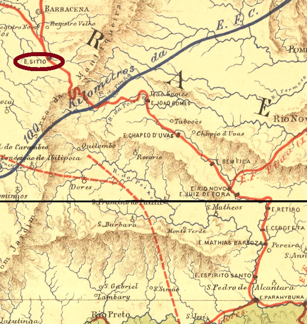
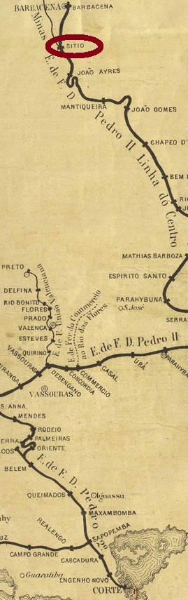
The Sítio train station was inaugurated in March 1878 (according to Paula Sobrinho) or in October of that year (according to Ralph M. Giesbrecht) by the E. F. Dom Pedro II railway company and was located on the main line (Linha do Centro) in the Município of Barbacena, 140 km south of the provincial capital Ouro Preto. With the Republic from 1889 on, the railway line was renamed E.F. Central do Brasil, and from 1975 until its closure in 1996 it belonged to Rede Ferroviária Federal S.A. (estacoesferroviarias.com.br). With the arisal of this area, the station was renamed Antonio Carlos in December 1948, and has been an independent município ever since.
Paula Sobrinho writes in História Postal de Minas Gerais (Belo Horizonte, 1997) that the station post office was created in March 1878. The only postmark of the imperial period so far is SMG-3635a (Coll. Karlheinz Wittig): a double circle with the inscription SITIO on top and an ornament in lozenge below, formed by four small lozenges. The dates in the middle are from the period 1888-1891.
Est. Ferroviarias do Rio de Janeiro, S. Paulo e Minas Geraes, 1880
Anderer Name: Antonio Carlos (Est.)
Der Bahnhof Sítio wurde im März 1878 (laut Paula Sobrinho) oder im Oktober d. Js. (laut Ralph M. Giesbrecht) durch die E. F. Dom Pedro II Bahngesellschaft eingeweiht und lag in der Hauptlinie (Linha do Centro) im Município von Barbacena, 140 km südlich der Provinzhauptstadt Ouro Preto entfernt. Mit der Republik ab 1889 wurde die Bahnlinie E.F. Central do Brasil umbenannt, von 1975 bis zur Stilllegung 1996 gehörte sie der Rede Ferroviária Federal S.A. (estacoesferroviarias.com.br). Mit dem Aufstieg dieser Gegend wurde der Bahnhof im Dezember 1948 Antonio Carlos umbenannt, der auch seitdem ein eigenständiger Município ist.
Paula Sobrinho schreibt in História Postal de Minas Gerais (Belo Horizonte, 1997), dass das Bahnhofspostamt im März 1878 entstanden ist. Der bisher einzige Poststempel der Kaiserzeit ist SMG-3635a (Samml. Karlheinz Wittig): ein Doppelkreis mit dem Inschrift SITIO oben und einem Ornament in Raute unten, das aus vier kleinen Rauten gebildet wird. Die Daten in der Mitte entstammen dem Zeitraum 1888-1891.
Villiers de l’Ile Adam: Carta (…) das Provincias de Pernambuco,Alagoas e Sergipe, 1848
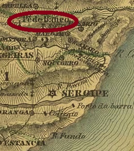
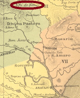
Another name: Pé do Banco
The district of Jesus, Maria e José do Pé do Banco (Jesus, Mary and Joseph at the Foot of the Bank) came into being in March 1839 in the Município of Divina Pastora (Heavenly Shepherdess) and was located on the north bank of the Riacho of the same name, just under 50 km north of the future provincial capital of Aracaju. Since March 1874, the place has been a vila and the seat of the Município of Siriry (today written with I at the end). The name means both a termite species and a bird of the Tyrannideae family in the Indian language Tupi-Guarani.
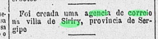
The local post office was established in June 1884, as reported by the Rio press:
Gazeta de Noticias/RJ, 18.06.1884
The imperial local postmark is SSE-0170a (Coll. José A. Junges): a double circle with the inscription SIRIRY above, there is below an ornament in lozenge, the four sides of which are open. The only copy so far is dated 1884 in the centre.
Atlas do Imperio do Brasil, 1868
Anderer Name: Pé do Banco
Der Distrikt von Jesus, Maria e José do Pé do Banco (Jesus, Maria und Joseph am Bankfuß) entstand im März 1839 im Município von Divina Pastora (Himmlische Hirtin) und lag am Nordufer des gleichnamigen Riacho, knapp 50 km nördlich der künftigen Provinzhauptstadt Aracaju. Seit März 1874 ist der Ort eine Vila und Sitz des Município von Siriry (heute mit I am Ende geschrieben). Der Name bedeutet in der Indianersprache Tupi-Guarani sowohl eine Termitenart als auch ein Vogel der Fam. Tyrannideae.
Das örtliche Postamt entstand im Juni 1884, wie die Presse aus Rio berichtet:
Gazeta de Noticias/RJ, 18.06.1884
Der kaiserliche Ortsstempel ist SSE-0170a (Samml. José A. Junges): ein Doppelkreis mit der obigen Inschrift SIRIRY, unten liegt ein Ornament in Raute, dessen vier Seiten offen sind. Das bisher einzige Exemplar ist 1884 in der Mitte datiert.
Est. Ferroviárias do Rio de Janeiro, S. Paulo e Minas Geraes, 1880
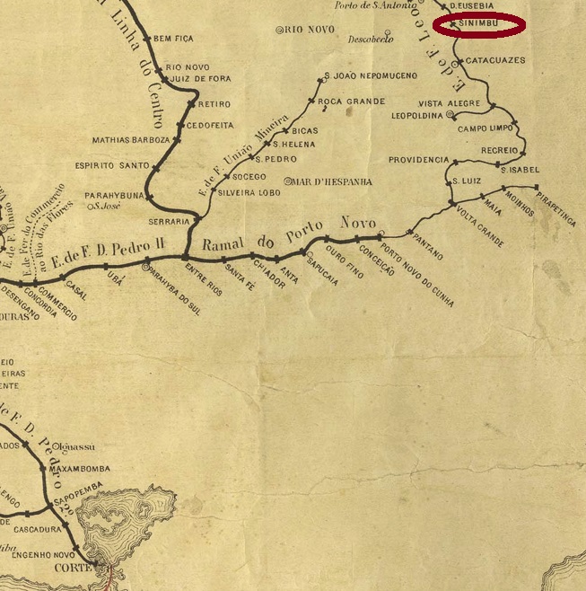
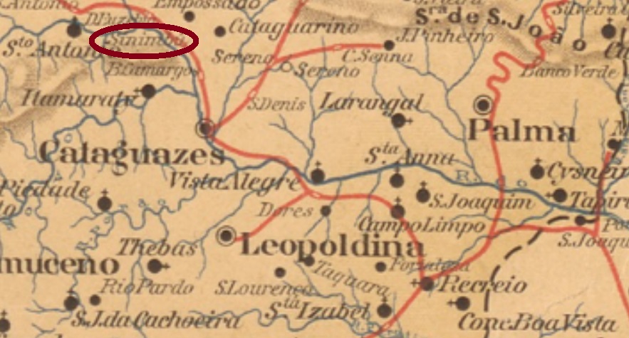
The Sinimbú train station was inaugurated in November 1878 by the E.F. Leopoldina Railway Company and was located in the so-called Recreio junction (Ramal de Recreio) in the Município of Cataguazes. The station was named after the fazenda, which was located on the north bank of the Rio Pomba, about 200 km southeast of the provincial capital Ouro Preto. The line belonged to Rede Ferroviária Federal S.A. from 1975 until its closure in 1996. (estacoesferroviarias.com.br).
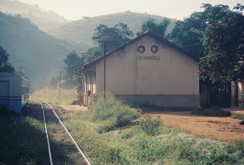
In 1990 (Photo: Hugo Caramuru, in estacoesferroviarias.com.br)
In his História Postal de Minas Gerais (Belo Horizonte, 1997), Paula Sobrinho writes that the station post office was created in July 1881. The only postmark from it so far is SMG-3130a (Coll. FM): a double circle with the inscriptions EST. DE SINIMBU above and (MINAS) below. The inner dates have unfortunately been found so far within the Republic: 1891 and 1892.
Estado de Minas Geraes, 1910
Der Bahnhof Sinimbú wurde im November 1878 durch die E.F. Leopoldina Bahngesellschaft eingeweiht und lag in der so genannten Recreio-Abzweigung (Ramal de Recreio) im Município von Cataguazes. Der Bahnhof wurde nach der Fazenda genannt, die am Nordufer des Rio Pomba lag, rund 200 km südöstlich der Provinzhauptstadt Ouro Preto entfernt. Die Linie gehörte von 1975 bis zur Stilllegung 1996 zur Rede Ferroviária Federal S.A. (estacoesferroviarias.com.br).
1990 (Foto: Hugo Caramuru, in estacoesferroviarias.com.br)
In seiner História Postal de Minas Gerais (Belo Horizonte, 1997) schreibt Paula Sobrinho, dass das Bahnhofspostamt im Juli 1881 entstanden ist. Der bisher einzige Poststempel davon ist SMG-3130a (Samml. FM): ein Doppelkreis mit den Inschriften EST. DE SINIMBU oben und (MINAS) unten. Die inneren Daten wurden bisher leider innerhalb der Republik gefunden: 1891 und 1892.
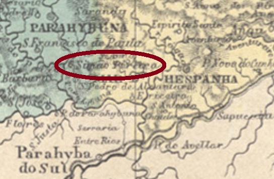
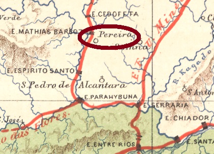
Other names: Nossa Senhora da Glória de Simão Pereira, São Pedro de Alcantara (1890-1943)
The history of the freguesia of Nossa Senhora da Glória de Simão Pereira (Our Lady of Glory of Simão Pereira) is accompanied by a long-standing rivalry with the neighbouring village of São Pedro de Alcantara, now called Ibiá. Simão Pereira was a freguesia of Juiz de Fora from May 1852 – this vila was then called Santo Antonio do Paraibuna, located close to the provincial border with Rio de Janeiro, over 240 km south of the provincial capital Ouro Preto. In 1890, the place was renamed as the district of S. Pedro de Alcantara and changed under this name to the newly founded Município of Mathias Barbosa in September 1923. It was not until December 1943 that the old name returned, and Simão Pereira has been a Município since December 1962.
As Paula Sobrinho writes in História Postal de Minas Gerais (Belo Horizonte, 1997), there has been a post office there since November 1861. Three imperial-era postmarks were found. SMG-3125a (Coll. José A. Junges) is the first of them: an ellipse with the inscription SIMÃO PEREIRA. It was followed by the French type SMG-3125b (Coll. Karlheinz Wittig): in the double circle one reads the inscription SIMAO PEREIRA above, below there is the star between brackets. The only one of these so far bears a date from 1884 in the centre. SMG-3125c (Coll. Paul Lepper) is the most common: a double circle with the inscription SIMĀO PEREIRA above and an ornament below formed by four branches in a cross. Found on D. Pedro issues from 1876 to 1886.
Estrada de Ferro Central do Brasil, 1890
Andere Namen: Nossa Senhora da Glória de Simão Pereira, São Pedro de Alcantara (1890-1943)
Die Geschichte der Freguesia von Nossa Senhora da Glória de Simão Pereira (Unsere Liebe Frau der Ehre von Simão Pereira) wird begleitet durch eine langjährige Rivalität mit dem Nachbarort São Pedro de Alcantara, der heute Ibiá heißt. Simão Pereira war ab Mai 1852 eine Freguesia von Juiz de Fora – die Vila hieß damals noch Santo Antonio do Paraibuna, die nah an der Provinzgrenze zu Rio de Janeiro lag, über 240 km südlich der Provinzhauptstadt Ouro Preto. 1890 wurde der Ort als Distrikt von S. Pedro de Alcantara umbenannt und wechselte unter diesem Namen im September 1923 zum neu gegründeten Município von Mathias Barbosa. Erst im Dezember 1943 kehrte der alte Name zurück, und seit Dezember 1962 ist Simão Pereira ein Município.
Wie Paula Sobrinho in História Postal de Minas Gerais (Belo Horizonte, 1997) schreibt, gibt es dort ein Postamt seit November 1861. Drei Poststempel der Kaiserzeit wurden gefunden. SMG-3125a (Samml. José A. Junges) ist der erste davon: eine Ellipse mit der Inschrift SIMÃO PEREIRA. Ihm folgte der Französischer Typus SMG-3125b (Samml. Karlheinz Wittig): im Doppelkreis liest man oben die Inschrift SIMAO PEREIRA, unten ist der Stern zwischen Klammern. Der bisher einzige Exemplar davon trägt ein Datum aus 1884 in der Mitte. SMG-3125c (Samml. Paul Lepper) kommt am häufigsten vor: ein Doppelkreis mit der Inschrift SIMĀO PEREIRA oben und einem Ornament unten, das aus vier Zweigen in Kreuz gebildet wird. Gefunden auf D. Pedro-Ausgaben von 1876 bis 1886.
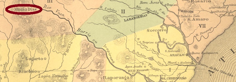
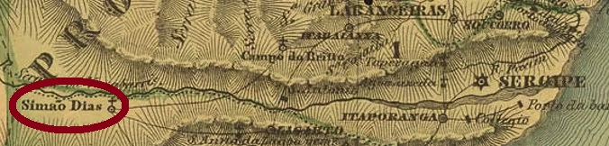
The district of Sant’Anna de Simão Dias was created in February 1835 in the Município of Lagarto and was located on the south bank of the river Caiçai, more than 100 km west of the provincial capital Aracaju. The place rose to the status of vila in March 1850 and town in June 1890. In October 1912, the name of the municipality was changed to Anapolis, but since December 1943 the município has been called Simão Dias again.
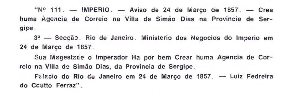
As Aureo G. Santos writes in Agências de Correio Criadas e Suprimidas 1851, 1855, 1856 e 1857 (in Brasil Filatélico 181, Rio de Janeiro, 1977), there was a post office there from March 1857:
Aureo G. Santos (op. cit.)
A single postmark for the Empire could be found: SSE-0165b (Coll. Fuad Ferreira Fo.), as a double-circle postmark, is probably not the oldest from there. It has the inscription SIMÃO DIAS at the top and its dates in the middle go from 1881 to 1887.
Villiers de l’Ile Adam: Carta (…) das Provincias de Pernambuco, Alagoas e Sergipe, 1848
Andere Namen: Sant’Anna de Simão Dias, Anapolis
Der Distrikt von Sant’Anna de Simão Dias entstand im Februar 1835 im Município von Lagarto und lag am Südufer des Flusses Caiçai, über 100 km westlich der Provinzhauptstadt Aracaju entfernt. Der Ort stieg im März 1850 zur Vila und im Juni 1890 zur Stadt auf. Im Oktober 1912 wurde der Name der Gemarkung zu Anapolis geändert, aber seit Dezember 1943 heißt der Município wieder Simão Dias.
Ein einziger Poststempel für das Kaiserreich war zu finden: SSE-0165b (Samml. Fuad Ferreira Fo.) ist als Doppelkreis-Poststempel wohl nicht der älteste von dort. Er hat die Inschrift SIMÃO DIAS oben und seine Daten in der Mitte gehen von 1881 bis 1887.