Categories
Carimbologia S

Santo Antonio do Carangola, Minas Gerais (SMG-3018) – Santo Antonio do Carangola (train station/Bahnhof), Rio de Janeiro (SRJ-0907)

Atlas do Imperio do Brasil, 1868

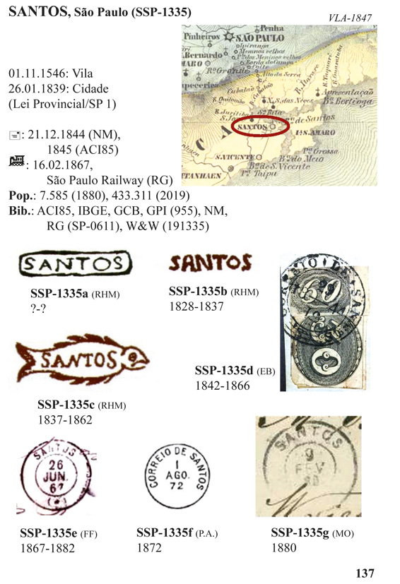
Other names: Santo Antonio de Porciúncula, Porciúncula (1938)

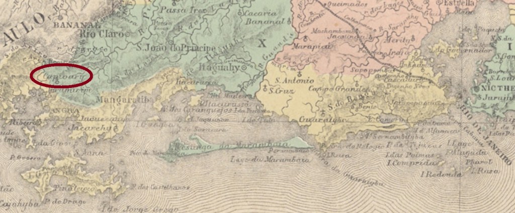
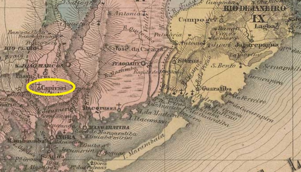
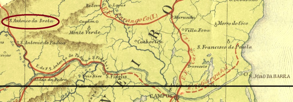
This is a very singular case of a locality which apparently had changed the province to profit from a train station, that also had its own post office. Its history began in April 1847, when the district of Santo Antonio do Carangola was founded in the municipality of São Paulo do Muriaé, Minas Gerais province, over 250 km southeast of the capital Ouro Preto. The location quite near the provincial border to Rio de Janeiro and the railroad run in the late 19th century must have caused considerable political tension in the region. So the village switched in November 1885 to the municipality of Itaperuna, now in the Rio province, and seven months later a train station was installed there by the Estrada de Ferro do Carangola. In November 1926 the toponym changed to Santo Antonio de Porciúncula, which had the name simplified to Ponciúncula in December 1938. Since June 1947 has Porciúncula an own municipality. The name is a tribute to the medical doctor José Tomás da Porciúncula (1854-1901), the first Rio de Janeiro governor elected after the republican strike.

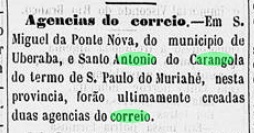
The local post office was created in September 1881, still in the Minas Gerais province, as reported by the press:

A Provincia de Minas, October 2, 1881

One postal cancel from this early period was found: SMG-3018a (Coll. José A. Junges) has a double circle with the inscription S. ANTONIO DO CARANGOLA above and a diamond ornament below, formed by four small diamonds. It was used from the beginning until at least 1887, i.e. already in the Rio province. The later cancels were probably originated from the train station, although no concrete reference has been found yet. SRJ-0907a (Coll. José A. Junges) has a double circle with the imprint S. ANTONIO DO CARANGOLLA above and an ornament in x-form below, dated 1888-89 at the centre. SRJ-0907b (image from the internet) could be already republican, for it was found dated 1892-1893 at the centre. In the double circle the inscription is now written S. ANTO. DO CARANGOLA, and the ornament below is a Maltese cross.

estacoesferroviarias.com.br

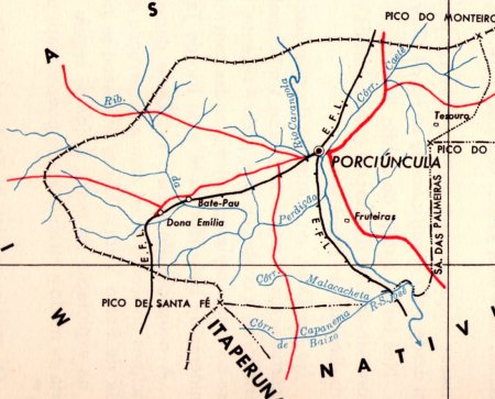
Andere Namen: Santo Antonio de Porciúncula, Porciúncula (1938)

Hier haben wir mit einem merkwürdigen Fall zu tun: eine Ortschaft wechselt die Provinzzugehörigkeit, um von einem Bahnhof – mit eigenem Postamt – zu profitieren. Die Geschichte beginnt im April 1847, mit der Distriktgründung von Santo Antonio do Carangola im Município von São Paulo do Muriaé der Provinz Minas Gerais, über 250 km südöstlich der Hauptstadt Ouro Preto entfernt. Die Lage nahe an der Provinzgrenze zu Rio de Janeiro und die rasche Expansion des Bahnschienennetzes im späten 19. Jahrhundert haben offenbar einen großen politischen Druck in der Region erzeugt. Also wechselte die Ortschaft im November 1885 zum Município von Itaperuna, nun in die Provinz Rio de Janeiro, und schon sieben Monate später ein Bahnhof war dort durch die Estrada de Ferro do Carangola eingeweiht. Im November 1926 wechselte der Ortsname zu Santo Antonio de Porciúncula, der wiederum im Dezember 1938 zu Ponciúncula verinfacht wurde. Seit Juni 1947 hat Porciúncula einen eigenen Município. Der Name soll an den Arzt und Politiker José Tomás da Porciúncula (1854-1901) erinnern, den ersten gewählten Gouverneur des Staates Rio de Janeiro nach dem Putsch, der die Republik mit sich brachte.

Das örtliche Postamt entstand im September 1881, noch in der Provinz Minas Gerais, wie die Regionalpresse berichtet:

A Provincia de Minas, 2. Oktober 1881

Ein Poststempel dieser Frühzeit ist vorhanden: SMG-3018a (Samml. José A. Junges) hat einen Doppelkreis mit der Inschrift S. ANTONIO DO CARANGOLA oben und einem Ornament in Rautenform unten, das aus vier kleinen Rauten besteht. Er wurde vom Betriebsbeginn bis mindestens 1887 verwendet, also innerhalb der Zeit in der Provinz Rio. Die beiden folgenden Stempel sind wohl aus der Bahnhofsagentur, obwohl keine konkreten Angaben dazu zu lesen sind. SRJ-0907a (Samml. José A. Junges) hat einen Doppelkreis mit S. ANTONIO DO CARANGOLLA oben und einem x-förmigen Ornament unten, datiert 1888-89 in der Mitte. SRJ-0907b (Abb. aus dem Internet) könnte bereits republikanisch sein, da beide Exemplare mit 1892-1893 in die Mitte datiert wurden. Im Doppelkreis lautet die Inschrift nun S. ANTO. DO CARANGOLA, und das untere Ornament ist ein Malteser Kreuz.

Categories
Carimbologia S

Santo Antonio de Capivary, Rio de Janeiro (SRJ-0895)

Atlas do Imperio do Brasil, 1868

Other names: Parado, Lídice (1943)

Santo Antonio de Capivary – which should not be confounded with the other Capivary (now Silva Jardim) in the Rio de Janeiro province – was a former freguesia in the municipality of Rio Claro, situated over 150 km west of the imperial capital.  In December 1938 the toponym changed to Parado and five years later, to Lídice. This actual name is a tribute to the small town Lidice, now in the Czech Republic, whose male population was executed by the nazi occupants on June 10, 1942.

We have found no less than four different years for the creation of the local post office. The 1859 report of the Directoria Geral dos Correios states it took place in 1854. Nova Monteiro (Administrações e Agencias Postaes do Brasil Imperio, in Brasil Filatelico/RJ, 1934-5; Reprint SPP 1994-1999) lists the agency from June 1855 on. Paulo Novaes (agenciaspostais.com.br) writes October 1861 and finally, the Imperial Mail Register (Tabella das Agencias do Correio do Imperio) of 1885 states this office was created in 1868. Probably the agency has been closed a couple of times in-between.

Only one early cancel was found, which is most probably not the earliest one. SRJ-0895b (Coll. Paulo Novaes) has a double circle with the inscription S. A. DE CAPIVARY above and the date inside. A sole example was found, dated 1897.

Villiers de l’Ile Adam: Carta (…) da Provincia do Rio de Janeiro, 1850

Andere Namen: Parado, Lídice (1943)

Santo Antonio de Capivary – nicht mit dem anderen Capivary (heute Silva Jardim) in der Provinz Rio de Janeiro zu verwechseln – war eine ehemalige Freguesia im Município von Rio Claro, die über 150 km westlich der kaiserlichen Hauptstadt Rio de Janeiro lag.  Im Dezember 1938 wechselte der Ortsname zu Parado und fünf Jahre später, zu Lídice. Diese aktuelle Bezeichnung ist eine Hommage an den kleinen böhmischen Dorf  Lidice, heute in der Tschechischen Republik, dessen Männerpopulation am 10. Juni 1942 von der Nazi-Besatzung hingerichtet wurde.

Nicht weniger als vier verschiedene Jahre wurden für das örtliche Postamt gefunden. Der Bericht der Directoria Geral dos Correios für 1859 nennt dafür das Jahr 1854. Nova Monteiro (Administrações e Agencias Postaes do Brasil Imperio, in Brasil Filatelico/RJ, 1934-5; Reprint SPP 1994-1999) listet die Agentur ab Juni 1855 auf. Paulo Novaes (agenciaspostais.com.br) schreibt Oktober 1861, und schließlich behauptet das Verzeichnis der kaiserlichen Postämter (Tabella das Agencias do Correio do Imperio) von 1885, das Postamt gibt es seit 1868. Wahrscheinlich blieb die Agentur einige Male zwischendurch geschlossen.

Ein einziger früher Stempel wurde gefunden, der wohl eher nicht der Älteste ist. SRJ-0895b (Samml. Paulo Novaes) hat einen Doppelkreis mit der Inschrift S. A. DE CAPIVARY oben und dem Datum in der Mitte. Das einzige vorhandene Exemplar trägt ein Datum von 1897.

Categories
Carimbologia S

Carimbologia S1: NEW/NEU

Available at/ erhältlich bei http://www.arge-brasilien.de/Publikationen/

After the 2019 release of the post offices with initials Q-R in Imperial Brazil, ArGe Brasilien proudly presents the continuation of Carimbologia do Brasil Clássico, a philatelic documentary project conceived and initiated by Reinhold Koester, which had remained unfinished since 1992. Following the author’s original intention to list alphabetically all Brazilian post offices between 1798 and ca. 1889, this book presents their cancels from Sabará (Minas Gerais) to São Jeronymo (Rio Grande do Sul) in the original orthography.

What’s new? The image quality of cancels and maps could be improved, due to developed technique and better sources. Some mute cancels are presented, whenever their identity is beyond doubt. To make search easier, there are cancel comparative tables for homonymous localities from different provinces (e.g. Santa Cruz, Santo Amaro).

All additional texts for every topic will be freely available here.

Die Arbeitsgemeinschaft Brasilien (ArGE Brasilien) im BDPh freut sich anzukündigen: Nach dem Fortsetzungsheft (Q-R) aus 2019 liegt nun der nächste Band der Carimbologia do Brasil Clássico vor, ein von Reinhold Koester angestoßenes Forschungsprojekt der philatelistischen Geschichte Brasiliens, das seit 1992 unvollendet geblieben war. Dem editorischen Originalplan folgend werden in diesem Heft die brasilianischen Poststempel von 1798 bis ca. 1889 ab Sabará (Minas Gerais) bis São Jeronymo (Rio Grande do Sul) vorgestellt, gemäß damaliger Schreibweise aufgelistet.

Was ist hier neu? Die Bildqualität bei Stempeln und Landkarten konnte durch reifere Technik und geeignete Quellen verbessert werden. Einige „stummen“ Stempel werden vorgestellt, wenn ihre Zuordnung zweifelsfrei ist. Um die Suche zu vereinfachen, gibt es kleine Vergleichstafeln mit Stempeln von gleichnamigen Orten aus verschiedenen Provinzen (z.B. Santa Cruz, Santo Amaro).

Die Begleittexte zu den jeweiligen Ortsnamen werden auf unbestimmte Zeit und kostenlos hier auffindbar.

Categories
Carimbologia S

Santo Antonio da Casa Branca, Minas Gerais (SMG-3485)

Atlas do Imperio do Brasil, 1868

Other names: Casa Branca, Glaura (1943)

This Santo Antonio da Casa Branca was since April 1841 a district of the provincial capital Ouro Preto, located approximately 30 km northwest of it. In December 1943 the toponym changed to Glaura, after a poem by Manuel Inácio da Silva Alvarenga (1749-1814), who was born in the region.

According to the Imperial Mail Register / Verzeichnis der kaiserlichen Postämter (Tabella das Agencias do Correio do Imperio) of 1885, the local post office opened in 1879. Paula Sobrinho (História Postal de Minas Gerais, Belo Horizonte, 1997) supposes it has closed later, for he had noticed a reopening date for May 1892. Anyway, one cancel from the first operation period was found: SMG-3485a (Coll. José A. Junges) has a double circle with the inscription S. ANTONIO DA CASA BRANCA above. Maybe there is also a ornament at the bottom, which is illegible in the sole example known. Dated 1885 at the centre.

Villiers de l’Ile Adam: Carta (…) da Provincia de Minas Geraes, 1849

Andere Namen: Casa Branca, Glaura (1943)

Dieser Santo Antonio da Casa Branca war ab April 1841 ein Distrikt der Provinzhauptstadt Ouro Preto, der ca. 30 km nordwestlich davon lag. Im Dezember 1943 wechselte der Ortsname zu Glaura, nach einem Gedicht von Manuel Inácio da Silva Alvarenga (1749-1814), einem Sohn dieser Region.

Laut Verzeichnis der kaiserlichen Postämter (Tabella das Agencias do Correio do Imperio) vom 1885 eröffnete 1879 das dortige Postamt. Paula Sobrinho (História Postal de Minas Gerais, Belo Horizonte, 1997) vermutet aber, die Agentur schloss bald wieder, denn er hat ein Wiedereröffnungsdatum von Mai 1892 gefunden. Wie es dem auch sei, ein Poststempel der ersten Betriebszeit ist vorhanden: SMG-3485a (Samml. José A. Junges) hat einen Doppelkreis mit der Inschrift S. ANTONIO DA CASA BRANCA oben. Vielleicht ist auch ein Ornament unten, aber das einzige bekannte Exemplar ist an der Stelle schlecht lesbar. Dafür ist das Datum von 1885 in der Mitte gut zu sehen.

Categories
Carimbologia S

Santo Antonio da Cachoeira, São Paulo (SSP-1325)

Atlas do Imperio do Brasil, 1868

Another name: Piracaia (1836-1859, 1906ff)

See also Cachoeira (R. Koester: Carimbologia VII)

According to R. Koester (Carimbologia VII) there were two localities named Santo Antonio da Cachoeira in the São Paulo province during the Brazilian Empire. The first one would be the actual Cachoeira Paulista, on the road to Rio de Janeiro. The other one is presented here: the former and actual Piracaia, situated in the Bragança region, round 100 km north of the provincial capital. Founded as the freguesia of Piracaia in March 1836 in the municipality of Atibaia, it switched to Nazareth in June 1850 and emancipated in March 1859 as the villa of Santo Antonio da Cachoeira. In March 1885 it was declared a town, which was called back to Piracaia from August 1906 on. The tupi word means roast fish.

The Imperial Mail Register (Tabella das Agencias do Correio do Imperio) of 1885 lists this post office from 1873 on. Three imperial cancels are registered. SSP-1325a (Coll. José A. Junges) is a wonderful cancellation, already presented by Koester and which was used at least until 1876:

SSP-1325a (J. A. Junges)

It was followed by SSP-1325b (Coll. José A. Junges): a double circle with the inscription S. A. DA CACHOEIRA. The dates at the centre were found for the period 1879-1890. The last cancel, SSP-1325c (image from the internet), is a French-type: a double circle with the inscription S. ANTO. DA CACHOEIRA above and the star between parentheses below. Dates found for 1889-1892.

Mappa da Provincia de São Paulo, 1886

Anderer Name: Piracaia (1836-1859, 1906ff)

Siehe auch Cachoeira (R. Koester: Carimbologia VII)

Laut R. Koester (Carimbologia VII) gab es zwei Ortschaften in der kaiserlichen Provinz São Paulo, die Santo Antonio da Cachoeira hießen. Die erste wäre die jetzige Cachoeira Paulista, die auf dem Weg nach Rio de Janeiro liegt. Von der anderen wird hier die Rede sein: die alte und auch aktuelle Piracaia, die in der Gegend von Bragança, rund 100 km nördlich der Provinzhauptstadt entfernt lag. Die Freguesia von Piracaia wurde im März 1836 im Município von Atibaia gegründet und wechselte zu Nazareth im Juni 1850. Erhielt seine politische Autonomie als die Villa von Santo Antonio da Cachoeira im März 1859 und stieg sechs Jahre später zu einer Stadt auf, die seit August 1906 wieder Piracaia heißt. Das Wort der Tupi-Sprache bedeutet Bratfisch.

Das Verzeichnis der kaiserlichen Postämter (Tabella das Agencias do Correio do Imperio) von 1885 listet dieses Postamt ab 1873 auf. Drei Stempel der Kaiserzeit sind überliefert. SSP-1325a (Samml. José A. Junges) ist eine wurderbare Abstempelung, die zumindest bis 1876 kursierte und bereits durch Koester vorgestellt wurde:

SSP-1325a (J. A. Junges)

Es folgte SSP-1325b (Samml. José A. Junges): ein Doppelkreis mit der Inschrift S. A. DA CACHOEIRA. Die Daten im Zentrum wurden für den Zeitraum 1879-1890 gefunden. Der letzte Stempel, SSP-1325c (Abb. aus dem Internet), ist ein Französischer-Typus: ein Doppelkreis mit der Inschrift S. ANTO. DA CACHOEIRA oben und dem Stern zwischen Klammern unten. Daten für die Jahre zwischen 1889 und 1892 vorhanden.

Categories
Carimbologia S

Santo Antonio dos Brotos, Rio de Janeiro (SRJ-1565)

Atlas do Imperio do Brasil, 1868

See also Miracema (R. Koester: Carimbologia XXVII)

Santo Antonio dos Brotos (also written das Brotas or da Brota) was a district of São Fidellis, situated almost 300 km north of the imperial capital Rio de Janeiro. According to the Brazilian Institute for Geography and Statistics (IBGE), the district was founded in September 1881, but Paulo Novaes (agenciaspostais.com.br) states that it took place already in January 1880. In March 1883 the toponym changed to Miracema, which emancipated as an own municipality in November 1935.

According to the Imperial Mail Register (Tabella das Agencias do Correio do Imperio) of 1885, the local post office was created in 1877. Paulo Novaes (op. cit.) writes it closed already in August 1885. No postal cancel of the Empire has been found to date.

Estrada de Ferro Central do Brasil, 1890

Siehe auch Miracema (R. Koester: Carimbologia XXVII)

Santo Antonio dos Brotos (auch das Brotas oder da Brota geschrieben) war ein Distrikt von São Fidellis, der fast 300 km nördlich der kaiserlichen Hauptstadt Rio de Janeiro entfernt lag. Laut dem brasilianischen Institut für Geografie und Statistik (IBGE) fand diese Gründung im September 1881 statt, doch Paulo Novaes (agenciaspostais.com.br) schreibt, dies sei bereits im Januar 1880 geschehen. Im März 1883 wechselte der Ortsname zu Miracema, der zu einer Stadt im eigenen Município im November 1935 aufstieg.

Im Verzeichnis der kaiserlichen Postämter (Tabella das Agencias do Correio do Imperio) von 1885 wird das örtliche Postamt ab 1877 aufgelistet. Paulo Novaes (op. cit.) zufolge schloss die Agentur allerdings bereits im August 1885. Kein Poststempel des Kaiserreichs wurde bisher gesichtet.

Categories
Carimbologia S

Santo Antonio da Boa Vista, São Paulo (SSP-1320)

Carta da Republica dos Estados Unidos do Brazil, 1892

Another name: Itaí (1920)

The Santo Antonio da Boa Vista in the São Paulo province was since April 1874 a freguesia in the municipality of Faxina, situated 300 km west of the province capital. In May 1891 it ascended to a vila and in December 1906, to a town, which was called Itaí from November 1920 on. This tupi word means river pebble.

According to the Imperial Mail Register (Tabella das Agencias do Correio do Imperio) of 1885, the local post office was created in 1876. One early cancel was found: SSP-1320a (Coll. Fuad Ferreira Fo.) is a French-Type: a double circle with the inscription S. ANTOo BOA VISTA above and the typical star between parentheses below. Dates at the centre between 1894 and 1905.

Monteiro & Oliveira: Mappa do Estado de São Paulo, 1927

Anderer Name: Itaí (1920)

Die Ortschaft Santo Antonio da Boa Vista in der Provinz São Paulo war ab April 1874 eine Freguesia im Município von Faxina, die 300 km westlich der Provinzhauptstadt lag. Im Mai 1891 stieg sie zur Villa und im Dezember 1906 zur Stadt auf, die wiederum seit November 1920 Itaí heißt. Das Tupi-Wort bedeutet Flussstein.

Laut Verzeichnis der kaiserlichen Postämter (Tabella das Agencias do Correio do Imperio) von 1885 entstand 1876 das örtliche Postamt. Ein früher Stempel war zu finden: SSP-1320a (Samml. Fuad Ferreira Fo.) ist ein Französischer-Typus: ein Doppelkreis mit der Inschrift S. ANTOo BOA VISTA oben und dem typischen Stern zwischen Klammern unten. Die Daten in der Mitte wurden für den Zeitraum 1894-1905 ermittelt.

Categories
Carimbologia S

Santo Antonio da Boa Vista, Rio Grande do Sul (SRS-0535)

Atlas do Imperio do Brasil, 1868

Santo Antonio da Boa Vista in the southern province of São Pedro do Rio Grande is another locality that seems to have vanished along the decades. It was a district of the municipality of Pelotas, situated over 200 km southwest of the province capital Porto Alegre and colonized mostly by german immigrants in late 19th century.

It was not yet possible to find out the creation date of the postal agency. Since it was listed in the 1880 Postal Guide, it has probably opened shortly before. But it must have closed quite soon, for it is absent in the Imperial Mail Register (Tabella das Agencias do Correio do Imperio) of 1885. No postal cancel of the Empire has been found until now.

Provincia de São Pedro do Rio Grande, 1877

Santo Antonio da Boa Vista in der südlichen Provinz São Pedro do Rio Grande ist wieder eine Ortschaft, die im Laufe der Jahrzehnten verschwunden zu sein scheint. Sie war ein Distrikt im Município von Pelotas, der über 200 km südwestlich der Hauptstadt Porto Alegre entfernt lag und von deutschen Einwanderern im späten 19. Jahrhundert kolonisiert wurde.

Bisher war es nicht möglich, das Entstehungsdatum des örtlichen Postamts zu ermitteln. Da es im Postführer von 1880 aufgelistet war, wäre ein zeitnahes Eröffnungsdatum durchaus denkbar. Aber lange war das Postamt nicht in Betrieb, denn er ist aus dem Verzeichnis der kaiserlichen Postämter (Tabella das Agencias do Correio do Imperio) von 1885 wieder verschwunden. Kein Poststempel der Kaiserzeit wurde bisher gefunden.

Categories
Carimbologia S

Santo Antonio da Boa Vista, Minas Gerais (SMG-4055)

Mappa do Estado de Minas Geraes, 1910

Another name: Boa Vista de Montes Claros

Santo Antonio da Boa Vista was since July 1850 a district of the municipality of São João da Ponte, situated over 600 km north of the provincial capital Ouro Preto. Since then, it has changed twice to other municipalities: in November 1877 to Sant’Anna de Contendas, and in September 1901 to Vila Brasília, before returning to São João da Ponte in December 1943.

According to Paula Sobrinho (História Postal de Minas Gerais, Belo Horizonte, 1997), the local post office was created in January 1883. No postal cancel of the Empire could be safely identified until now.

Google Maps

Anderer Name: Boa Vista de Montes Claros

Santo Antonio da Boa Vista war ab Juli 1850 ein Distrikt im Município von São João da Ponte, der über 600 km nördlich der Provinzhauptstadt Ouro Preto entfernt lag. Seitdem wechselte die Ortschaft zweimal zu anderen Gemeinden: im November 1877 zu Sant’Anna de Contendas und im September 1901 zu Vila Brasília, und kehrte zum ursprünglichen Município von São João da Ponte im Dezember 1943 endgültig zurück.

Wie Paula Sobrinho in seiner História Postal de Minas Gerais (Belo Horizonte, 1997) berichtet, entstand das örtliche Postamt im Januar 1883. Keine postalische Abstempelung von dort konnte bisher sicherlich identifiziert werden.

Categories
Carimbologia S

Santo Antonio da Boa Vista, Alagoas (SAL-0245) NEW/NEU!

Arthur D. Ribeiro: Mappa do Estado do Alagoas, 1923

Print edition update of November 12, 2020

Santo Antonio da Boa Vista was since March 1872 a district in the municipality of Muricy, situated on the east bank of the Mundaú River, round 90 km northwest of the provincial capital Maceió. In May 1962 it became a quarter in the newly created municipality of Branquinha.

According to the Imperial Mail Register ( / Verzeichnis der kaiserlichen Postämter /Tabella das Agencias do Correio do Imperio, Rio de Janeiro, ) of 1885, the local post office was created in July 1884, which can be confirmed by the Rio press:

Diario do Brazil/RJ, July 11, 1884

However, Aldo Cardoso (Contribuição para a História dos Correios de Alagoas, Maceió, 1969) states this agency was closed as soon as 1894. No cancel of the Empire has been found until now.

Google Maps

Buchtext-Aktualisierung von 12. November 2020

Santo Antonio da Boa Vista war ab März 1872 ein Distrikt im Município von Muricy, der an Ostufer des Flusses Mundaú, rund 90 km nordwestlich der Provinzhauptstadt Maceió entfernt lag. Im Mai 1962 wurde daraus ein Stadtteil des neulich gegründeten Município von Branquinha.

Laut Verzeichnis der kaiserlichen Postämter  (Tabella das Agencias do Correio do Imperio) von 1885 gab es dort ab Juli 1884 ein Postamt, wie die Presse aus Rio bestätigen kann:

Diario do Brazil/RJ, 11. Juli 1884

Allerdings wurde die Agentur bereits 1894 geschlossen, wie Aldo Cardoso (Contribuição para a História dos Correios de Alagoas, Maceió, 1969) berichtet. Kein Poststempel des Kaiserreichs konnte bisher gefunden werden.