Villiers de l’Ile Adam: Carta (…) da Provincia do Espirito Santo, 1850
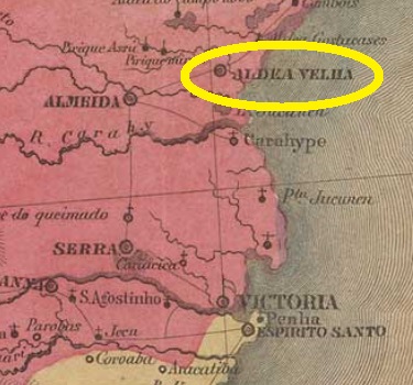
Other name: Aldeia Velha
This Santa Cruz was the former Freguesia of Aldeia Velha (= Old Village), established in December 1837 in the municipality of Nova Almeida, situated over 80 km north of the former province capital Villa do Espírito Santo (now Vila Velha). In April 1848 it ascended to a villa in own municipality, named Santa Cruz, which became a town in March 1891. In December 1943 the toponym was changed to the actual Aracruz.
According to Nova Monteiro (Administrações e Agencias Postaes do Brasil Imperio, in Brasil Filatelico/RJ, 1934-5; Reprint SPP 1994-1999), the local post office was created in October 1831. This would mean there is a possible cancel featuring Aldeia Velha, which yet has never appeared. Since Paulo Novaes (agenciaspostais.com.br) lists this agency with creation date “ca. 1856”, it may have been closed in the meantime.
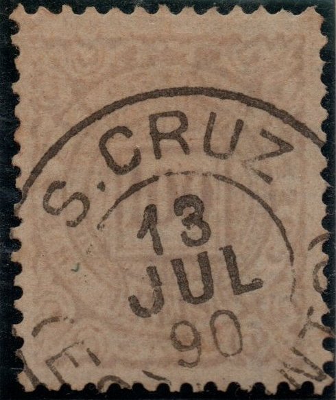
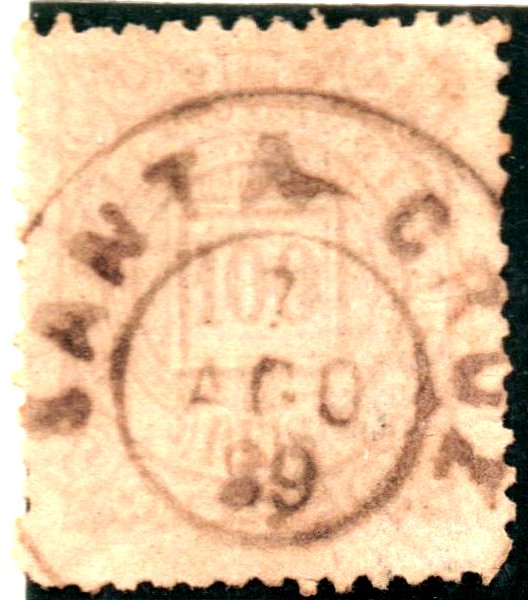
One imperial cancel could be to date safely identified, but it is surely not the earliest one, for it shows using dates between 1886 and 1903. SES-0165b (Coll. José A. Junges) has a double circle with the inscriptions S. CRUZ above and (ESP. SANTO) below, with date in the centre.
For actual information about the Santa Cruz cancel disambiguation see also:
Diese Santa Cruz hieß ursprünglich Freguesia von Aldeia Velha (= Altes Dorf), gegründet im Dezember 1837 im Município von Nova Almeida und über 80 km nördlich der ehemaligen Provinzhauptstadt Villa do Espírito Santo (heute: Vila Velha) gelegen. Im April 1848 wurde sie zu einer eigenständigen Villa unter dem Namen Santa Cruz, die im März 1891 zur Stadt wurde. Im Dezember 1943 wechselte der Ortsnamen zum heutigen Aracruz.
Laut Nova Monteiro (Administrações e Agencias Postaes do Brasil Imperio, in Brasil Filatelico/RJ, 1934-5; Reprint SPP 1994-1999) entstand das örtliche Postamt im Oktober 1831. Dadurch wäre ein Stempel mit Aldeia Velha möglich, der allerdings bisher nicht aufgetaucht ist. Da Paulo Novaes (agenciaspostais.com.br) diese Agentur mit Entstehungsjahr “ca. 1856” auflistet, könnte sie zwischendurch mal geschlossen gewesen sein.
Ein Stempel aus der Kaiserzeit konnte bisher zweifelsfrei hierher zugeordnet werden. Der ist aber sicher nicht der älteste, da die Verwendungsdaten aus den Jahren 1886-1903 stammen. SES-0165b (Samml. José A. Junges) hat einen Doppelkreis mit den Inschriften S. CRUZ oben und (ESP. SANTO) unten, dazu das Datum in der Mitte.
Zum Problemkomplex der Unterscheidung zwischen den Santa Cruz-Stempeln siehe auch:
Villiers de l’Ile Adam: Carta (…) da Provincia da Bahia, 1848
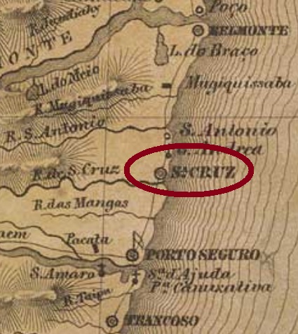
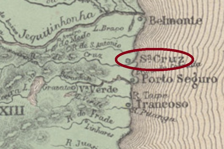
Santa Cruz is supposedly one of the first Portuguese settlements in Brazil, whose initial date would be May 1st, 1500, when Pedro A. Cabral erected the cross to celebrate one of the first masses in the officially discovered land. The locality was since May 1833 a villa, but lost its autonomy in July 1931, becoming a district of Porto Seguro. In 1933 the toponym was changed to Santa Cruz Cabrália, and finally in March 1938 it was elevated to a town within an own municipality.
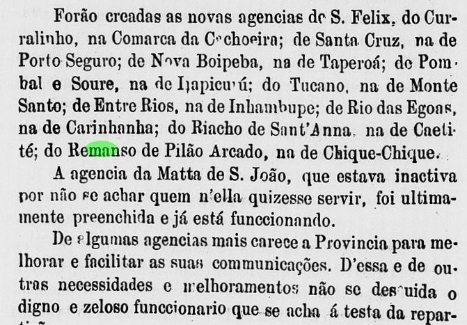
According to the Imperial Mail Register (Tabella das Agencias do Correio do Imperio) of 1885, the local post office was created in 1873, but it apparently had to close soon after, for a reopening was announced by the Bahia Government Council report for 1876:
Relatorio do Conselho Interino do Governo da Bahia, 1876
Santa Cruz ist wohl eine der ersten portugiesischen Siedlungen in Brasilien, eingeleitet angeblich am 1. Mai 1500, als Pedro A. Cabral das erste Kreuz errichtete, um eine Messe im neu entdeckten Land zu feiern. Die Ortschaft war seit Mai 1833 eine Villa, die im Juli 1931 ihre politische Autonomie verlor und ein Distrikt von Porto Seguro wurde. 1933 wurde der Ortsname auf Santa Cruz Cabrália geändert, und schließlich im März 1938 erhielt Santa Cruz Cabrália den Status einer Stadt im eigenen Município.
Laut dem Verzeichnis der kaiserlichen Postämter (Tabella das Agencias do Correio do Imperio) von 1885 entstand 1873 das örtliche Postamt. Das musste wohl aber bald wieder schließen, denn eine Neueröffnung wurde bereits 1876 durch den Regierungsrat Bahias angekündigt:
Relatorio do Conselho Interino do Governo da Bahia, 1876
Zum Problemkomplex der Unterscheidung zwischen den Santa Cruz-Stempeln siehe auch:
Before presenting every Santa Cruz post office in the Brazilian Empire, let’s face the problem upon the attribution of their cancels. Since most of these villages were rather small, they haven’t presented us yet enough examples (cancelled stamps, letters or postal stationaries) to enable clear cancel identification in every case. This task takes time, and we also need the help of our readers.
The best way to solve this problem is to state it as clearly as possible and to inform every step toward solution. So can the reader at once notice what has been already done and which data are still missing.
First, there are here all known Santa Cruz post offices – without other detailing additions like e.g. “…das Palmeiras” – listed from old to new creation date:
Santa Cruz/Goyaz (SCGO): March 5, 1829 and/or 1832
Santa Cruz/Espirito Santo (SCES): October 12, 1831 and/or 1856
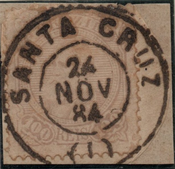
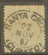
Santa Cruz (Curato)/Municipio Neutro (SCMN): November 24, 1842
Santa Cruz/Rio Grande do Sul (SCRS): September 21, 1864
Santa Cruz/Bahia (SCBA): 1873 and/or 1875/6
Santa Cruz/Rio Grande do Norte (SCRN): 1874
Santa Cruz/Pernambuco (SCPE): June 12, 1882
Santa Cruz (Arraial)/Rio de Janeiro (SCRJ): December 22, 1883
Bevor die einzelnen Postämter namens Santa Cruz aus dem brasilianischen Kaiserreich vorgestellt werden, soll hier kurz das Zuordnugsproblem ihrer Stempel erläutert werden. Da die meisten dieser Ortschaften eher klein waren, lieferten sie bisher nicht genug Material (abgestempelte Marken, Briefe oder Ganzsachen) um eine genaue Identifizierung in jedem Fall zu erlangen. Diese Ergebnisse brauchen noch Zeit, und wir brauchen die Hilfe unserer Leser.
Das Problem löst sich am besten, wenn es möglichst genau beschrieben, und jedes Zwischenergebnis protokolliert wird. Dadurch erfährt der Leser sowohl war bisher erreicht wurde, als auch welche Daten noch gesucht werden.
Zunächst listen wir alle bekannten Santa Cruz-Postämter – ohne Zusätze, wie z.B. „… das Palmeiras“ – nach der Reihenfolge ihrer Entstehung auf:
Santa Cruz/Goyaz (SCGO): 5. März 1829 und/oder 1832
Santa Cruz/Espirito Santo (SCES): 12. Oktober 1831 und/oder 1856
Santa Cruz (Curato)/Municipio Neutro (SCMN): 24. November 1842
Santa Cruz/Rio Grande do Sul (SCRS): 21. September 1864
Santa Cruz/Bahia (SCBA): 1873 und/oder 1875/6
Santa Cruz/Rio Grande do Norte (SCRN): 1874
Santa Cruz/Pernambuco (SCPE): 12. Juni 12, 1882
Santa Cruz (Arraial)/Rio de Janeiro (SCRJ): 22. Dezember 1883
Second, here one can see all existing Santa Cruz cancel types found to date, listed from old to new whenever possible.
Anschließend zeigen wir alle in der Imagebank bisher vorhandenen Stempel, wenn möglich in chronologischer Folge:
a)
Attributed by RHM to SCGO through similarity with other cancels from Goyaz. Found on Bull’s Eyes (1843 issue). Also possible: SCES or SCMN. Not in P. Ayres. / Laut RHM handelt es sich um SCGO, wg Ähnlichkeiten mit anderen Beispielen aus Goyaz. Gefunden auf Ochsenaugen (1843ff). Auch möglich: SCES oder SCMN. Nicht in P. Ayres.
b)
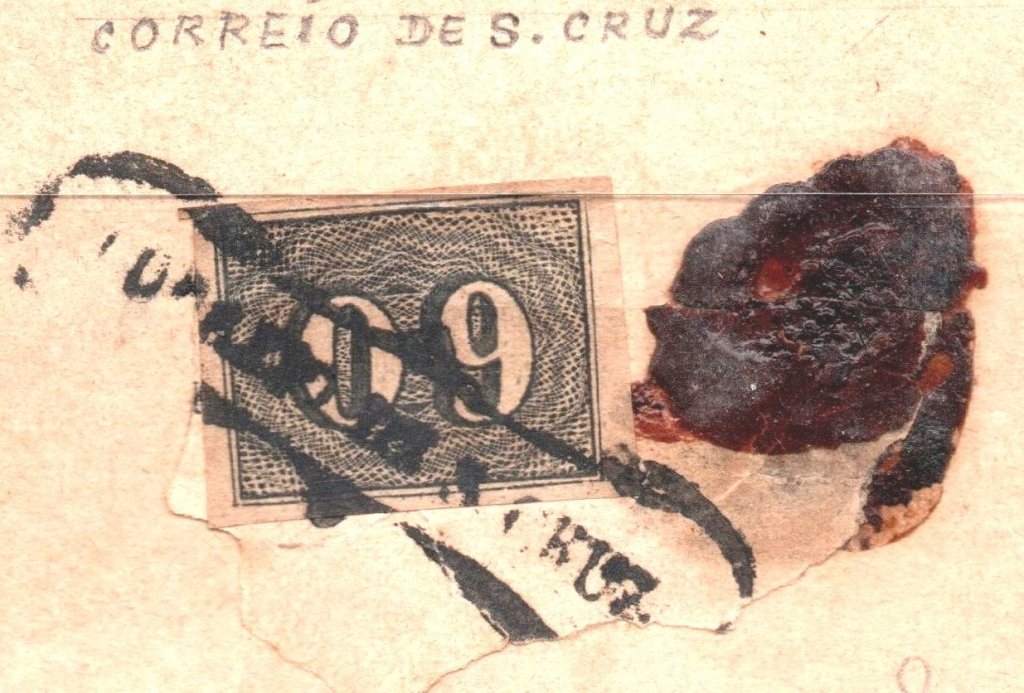
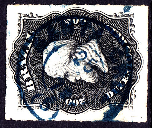
(Coll. José A. Junges). Legend CORREIO DE S. CRUZ, used on numerals (1850 issue). Likely possible for SCGO, SCES, SCMN or SCRS. Not in P. Ayres. / (Samml. José A. Junges). Legende CORREIO DE S. CRUZ auf Zifferausgabe v. 1850ff. Denkbare Alternativen: SCGO, SCES, SCMN oder SCRS. Nicht in P. Ayres.
c)
(Coll José A. Junges) Readily identifiable as SCMN. No date, 1866ff. / (Samml. José A. Junges) Leicht identifizierbar als SCMN. Kein Datum, 1866 ff.
d)
(Coll. José A. Junges) Legend SANTA CRUZ (+?) Possibly SCES through similarity with other Espirito Santo cancels from that time. No date. Used 1876ff. Not in P. Ayres. / (Samml. José A. Junges) Legende SANTA CRUZ (+?). Möglicherweise SCES, durch Ähnlichkeit mit anderen Stempeln aus Espirito Santo aus der Epoche. Kein Datum. 1876ff in Gebrauch. Nicht in P. Ayres.
e)
(Coll. Karlheinz Wittig. Legend SANTA CRUZ and (5) below. Identified as SCRS. Different colours. Dates 1876-1889. / (Samml. Karlheinz Wittig) Legende SANTA CRUZ, dazu (5) unten. Als SCRS festgestellt. Verschiedene Farben. Datiert 1876-1889.
f)
(image from the internet) Legend SANTA CRUZ. Same as before? Dated 1878. / (Abb. aus dem Internet) Legende SANTA CRUZ. Wie vor? Datiert 1878.
g)
(Coll. José A. Junges) Legend SANTA CRUZ. (I) below. Dated Nov 1884. MPT 806. / (Samml. José A. Junges) Legende SANTA CRUZ. (I) unten. Datiert Nov. 1884. MPT 806.
h)
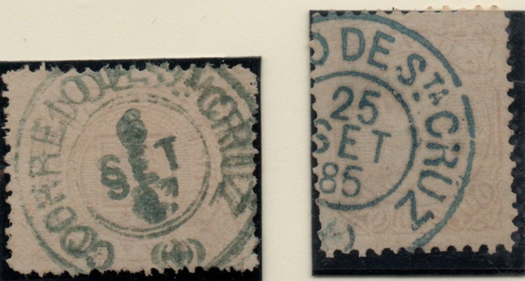
(Coll. José A. Junges) Legend CORREIO DE STA. CRUZ. Unidentified symbol in parentheses below. Different colours. Dates 1885-89. / (Samml. José A. Junges) Legende CORREIO DE STA.CRUZ. Unlesbarer Symbol in Klammern unten. Verschiedene Farbe, Datiert 1885-89.
i)
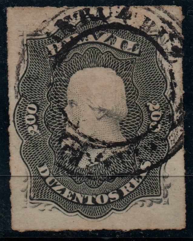
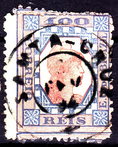
(Coll. José A. Junges). Legend S.CRUZ above and (ESP.SANTO) below. Readily identifiable as SCES. Dates 1886-1903. / (Samml. José A. Junges). Legende S.CRUZ oben und (ESP. SANTO) unten. Leicht identifizierbar als SCES. Datiert 1886-1903.
j)
(image from the internet) Readily identifiable as SCMN. Dates 1887-99. / (Abb. aus dem Internet). Leicht identifizierbar als SCMN. Datiert 1887-99.
k)
(Coll. José A. Junges). Legend SANTA CRUZ. Nothing below. Dated Aug 1889. / (Samml. José A. Junges). Legende SANTA CRUZ. Unten leer. Datiert Aug 1889.
(Coll. Fuad Ferreira Fo.) Legend … DE S. CRUZ within frame. On 1876 issue. Not in P. Ayres / (Samml. Fuad Ferreira Fo.) Inschrift …DE S. CRUZ im Rahmen. Auf Marke von 1876. Nicht in P. Ayres.
What next? To identify all cancels we ask for images of further examples showing letters, dates, destinations, stamps, different colours or even undiscovered cancels. Every hint may be useful. Please at least 300 dpi. Images can be sent to jm-karlruhe@web.de. / Nächster Schritt: Um alle Stempel bestimmen zu können, benötigen wir Bilder von weiteren Marken, Briefen, Zielorten, Farben, oder auch von unbekannten Stempeln. Jedes Bild hilft, bitte mit mindestens 300 dpi Auflösung. Alle Bilder können an jm-karlsruhe@web.de versendet werden.
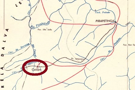
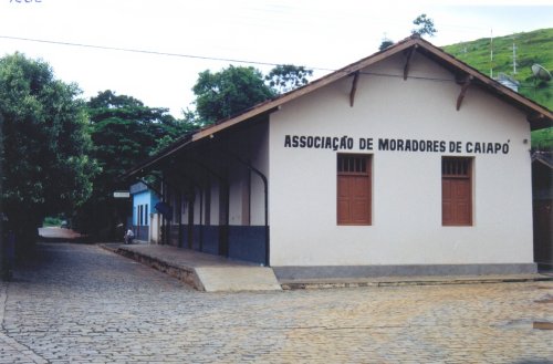
The Santa Clara station was inaugurated in January 1880 by the Estrada de Ferro do Pirapetinga railway in the actual district of Caiapó, about 300 km southeast of the province capital Ouro Preto. In 1883 the rail line passed to the E. F. Leopoldina railway and remained active until 1964. After 1889 the station was renamed to Dr. Astolfo, but by 1924 it acquired the definitive name of Caiapó from the small brook that also named the district. Now the station building serves as a community centre (estacoesferroviarias.com.br).
According to Paula Sobrinho (História Postal de Minas Gerais, Belo Horizonte, 1997), the station post office was created in July 1880. This year is confirmed by the Imperial Mail Register (Tabella das Agencias do Correio do Imperio) of 1885. One imperial cancel was found, whose attribution still awaits confirmation. SMG-2825a (Coll. José A. Junges) has a double circle with the inscription SANT. CLARA above. The dates in the centre were found within the period 1886-1893.
In 2004 (Photo: Gutierrez L. Coelho, apud estacoesferroviarias.com.br)
Der Bahnhof Santa Clara wurde im Januar 1880 durch die Estrada de Ferro do Pirapetinga Eisenbahngesellschaft eingeweiht und lag im heutigen Distrikt von Caiapó, etwa 300 km südöstlich der ehemaligen Provinzhauptstadt Ouro Preto entfernt. 1883 ging die Bahnlinie zur Estrada de Ferro Leopoldina und blieb bis 1964 in Betrieb. Nach 1889 wurde der Bahnhof Dr. Astolfo umbenannt, aber bis 1924 erhielt er den endgültigen Namen Caiapó, wie der kleine Bach, der auch den Distrikt nannte. Nun dient das Bahnhofsgebäude als Gemeindezentrum (estacoesferroviarias.com.br).
Laut Paula Sobrinho (História Postal de Minas Gerais, Belo Horizonte, 1997) entstand das Bahnhofspostamt im Juli 1880. Das Jahr wird durch das Verzeichnis der kaiserlichen Postämter (Tabella das Agencias do Correio do Imperio) von 1885 bestätigt. Ein Poststempel der Kaiserzeit wurde gefunden, dessen Zuordnung noch nicht sicher ist. SMG-2825a (Samml. José A. Junges) hat einen Doppelkreis mit der Inschrift SANT. CLARA oben. Die Daten in der Mitte stammen aus dem Zeitraum 1886-1893.
Atlas do Imperio do Brasil (Bahia), 1868Atlas do Imperio do Brasil (Minas Geraes), 1868
Other names: Santa Clara do Mucury, Mucury, Aymorés, Indiana, Nanuque (1943)
See also Mucury (Koester: Carimbologia XXVIII)
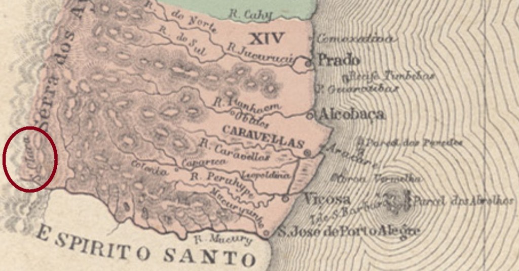
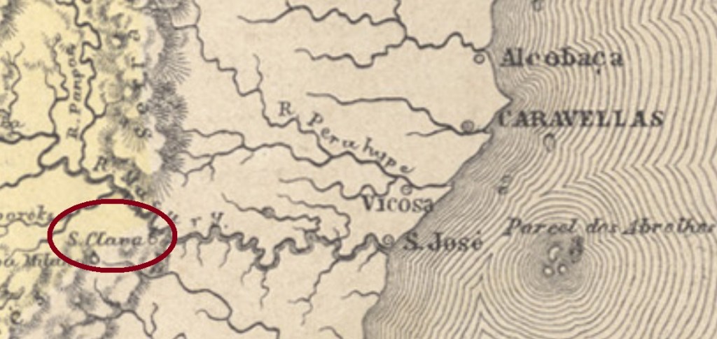
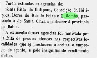
Here we have once more a fascinating story about a post office in a locality with a turbulent history. Santa Clara began as a colony of the municipality of São José de Porto Alegre (now the town of Mucuri) in the Bahia province, situated on the Mucury River, over a thousand km south of the province capital Salvador. Since it was located near the border to two other provinces (Minas Gerais and Espírito Santo), for some strategic reason it must have been disputed among them, for it not only has caused often changes in the border lines, but also appears in different provinces on maps from the same year and author (see above).
Apparently, the origin of Santa Clara’s attractiveness was related with plans about separating the Minas Gerais province in two halves during the empire. Considering that the capital of the northern province would be Philadelphia (now: Teófilo Otoni), it is quite probable that Teophilo B. Ottoni (1807-1869) initiated and followed this goal. The influent journalist, entrepreneur and politician started many traffic projects in the region: the road between Philadelphia and Santa Clara, inaugurated in August 1857 as the first one in the Brazilian Empire, the Bahia-Minas Railway, which would link both provinces from 1881 on, and the Mucury River Navigation Company in the fifties, which intended to facilitate European immigration.
Ottoni’s premature death stopped most of those projects, but Santa Clara went to Minas Gerais as a district to the municipality of Minas Novas in November 1877, and changed in October 1881 as the freguesia of Santa Clara do Mucury to the municipality of Teophilo Ottoni. In December 1902 it became the district of Aymorés, which changed the toponym to Indiana in September 1923. In December 1938 it passed as a district to the new municipality of Carlos Chagas, and changed in December 1943 the toponym again, to Nanuque. Finally, in December 1948 Nanuque was given an own municipality.
According to the Imperial Mail Register (Tabella das Agencias do Correio do Imperio) of 1885, the local post office was created in 1867, still in the Bahia province. Indeed, there were even before that time postal services along the Mucury River, as the Rio press reports:
Jornal do Commercio, Rio de Janeiro, December 25, 1861
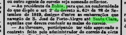
Some time later, this agency must have passed to the control of Minas Gerais, because by May 1872 it returned to Bahia, as noticed by the Minas Gerais press:
O Noticiador de Minas, May 1st. 1872
It is still uncertain when it returned definitively to Minas Gerais, but since it is mentioned in the Bahia press until ca. 1880, one can assume that around that time Santa Clara changed the province for good.
The earliest cancels were already presented by R. Koester under Mucury (Carimbologia XXVIII). There were also two imperial cancels from later times, whose attribution might be uncertain. SBA-0645a (image from the internet) is a French-type: a double circle with the inscription SANTA CLARA above and the small star between parentheses below. The date is usually missing, but the existing objects were used between ca. 1876 and 1891. SBA-0645b (image from the internet) is similar to the former, but presents no star. The dates in the centre show years between 1877 and 1893.
Mapa Geral do Brazil, 1911
Andere Namen: Santa Clara do Mucury, Mucury, Aymorés, Indiana, Nanuque (1943)
Siehe auch Mucury (Koester: Carimbologia XXVIII)
Hier haben wir wieder mit dem faszinierenden Fall eines Postamtes zu tun, dessen turbulente Geschichte viele Kapriolen schlug. Santa Clara war ursprünglich eine Kolonie im Município von São José de Porto Alegre (heute: Mucuri), die am Ufer des Mucuri über tausend km südlich der Provinzhauptstadt Salvador da Bahia entfernt lag. Da sie direkt an der Grenze zu zwei weiteren Provinzen (Minas Gerais und Espirito Santo) strategisch lag, wurde sie jahrzehntelang ein begehrtes Objekt. Santa Clara sollte mehrmals die Seite wechseln und schaffte es sogar, auf der gleichen Karte zwei unterschiedlichen Provinzen zugeordnet zu sein (siehe Abb. ganz oben).
Scheinbar hatte der Reiz Santa Claras mit alten Plänen zu tun, die kaiserliche Provinz Minas Gerais zu teilen. Da die geplante Hauptstadt der daraus entstehenden nördlichen Provinz Philadelphia (heute: Teófilo Otoni) sein sollte, ist es gut möglich, dass die Spaltungsidee aus dem Umkreis von Teophilo B. Ottoni (1807-1869) entsprang. Dieser einflussreiche Journalist, Unternehmer und Politiker initiierte mehrere Verkehrsprojekte in der Region: eine im August 1857 eingeweihte Strasse zwischen Philadelphia und Santa Clara (die erste Fernstrasse des brasilianischen Kaiserreichs), die Bahia-Minas Eisenbahngesellschaft, die die gleichnamigen Provinzen miteinander verbinden sollte, oder die Flussschifffahrtsgesellschaft Rio Mucury, die die europäische Einwanderung erleichtern sollte.
Ottonis früher Tod brachte einige der Projekte zum Erliegen, aber Santa Clara ging im November 1877 nach Minas Gerais als ein Distrikt des Município von Minas Novas und wechselte im Oktober 1881 als die Freguesia von Santa Clara do Mucury zum Município von Teophilo Ottoni. Im Dezember 1902 hieß der Distrikt Aymorés und ab September 1923 wurde er Indiana genannt. Im Dezember 1938 gehörte er zum neu gegründeten Município von Carlos Chagas und im Dezember 1943 wechselte der Ortsname abermals, zu Nanuque. Seit Dezember 1948 ist Nanuque ein eigener Município.
Laut Verzeichnis der kaiserlichen Postämter (Tabella das Agencias do Correio do Imperio) von 1885 entstand das örtliche Postamt in 1867, also noch in der Provinz Bahia. Allerdings gab es schon vorher Postverkehr entlang des Mucury, wie die Presse aus Rio berichtet:
Jornal do Commercio, Rio de Janeiro, 25. Dezember 1861
Irgendwann später musste dieses Postamt Minas Geraes zugeordnet gewesen sein, denn im Mai 1872 wurde die Rückkehr in die Provinz Bahia bekannt gemacht:
O Noticiador de Minas, 1. Mai 1872
Es ist auch nicht bekannt, wann genau Santa Clara nach Minas Gerais definitiv zurückkehrte. Da sie in der Presse Bahias bis ca. 1880 erwähnt wird, können wir davon ausgehen, dass dieser letzte Wechsel um diese Zeit stattgefunden hat.
Die frühesten Stempel dieser Ortschaft wurden bereits durch R. Koester unter Mucury vorgestellt (Carimbologia XXVIII). Aus späteren Zeiten haben wir zwei weitere Stempel, deren Zuordnung noch nicht gesichert ist. SBA-0645a (Abb. aus dem Internet) ist ein Französicher-Typ: ein Doppelkreis mit der Inschrift SANTA CLARA oben und dem kleinen Stern zwischen Klammern unten. Das Datum fehlt meistens, aber die vorhandenen Objekte wurden zwischen ca. 1876 und 1891 verwendet. SBA-0645b (Abb. aus dem Internet) ist ähnlich wie sein Vorgänger, hat aber kein Sternchen. Die Daten in der Mitte weisen Jahreszahlen zwischen 1877 und 1893 auf.
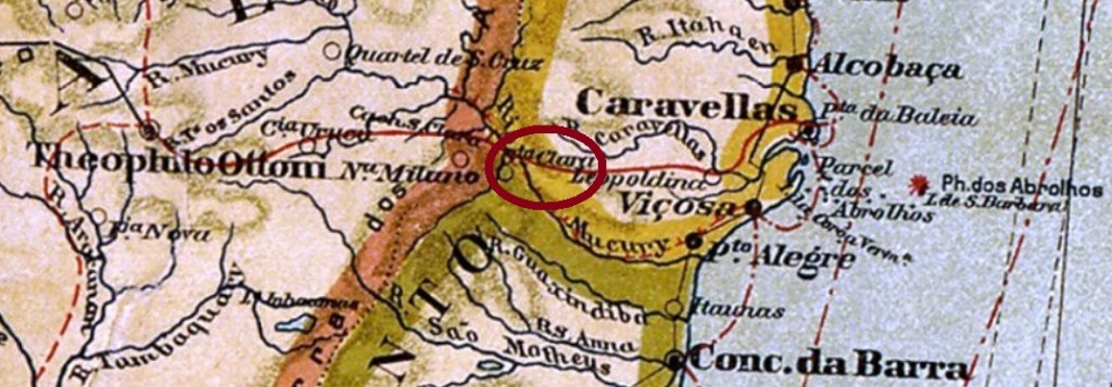
The district of Santa Christina do Pinhal was created in May 1893 on the south bank of the Sinos River in the municipality of Taquara do Mundo Novo (today just Taquara). The Imperial Mail Guide (Guia Postal do Império do Brazil) of 1880 lists the freguesia with 5.648 inhabitants, an amazing number, if compared to the ca. 1.700 people counted by the IBGE in 2000. Since May 1982 is Santa Cristina a district of the municipality of Parobé, situated over 70 km northeast of the capital Porto Alegre.
According to the Imperial Mail Register (Tabella das Agencias do Correio do Imperio) of 1885, the local post office was created in 1871. Two cancels have appeared to date. SRS-0385a (Coll. José A. Junges) has a double circle with the inscription SANTA CHRISTINA above. The date of the sole exemplar is 1881, in the centre. SRS-0385b (Coll. José A. Junges) features the same as before, but now the inscription is S. CHRISTINA and there is an unidentified ornament below. The only copy is dated 1887.
Carta da Republica dos Estados Unidos do Brazil, 1892
Anderer Name : Santa Christina do Pinhal
Der Distrikt von Santa Christina do Pinhal bestand seit Mai 1893 im Município von Taquara do Mundo Novo (heute : Taquara) am Südufer des Flusses Sinos, über 70 km nordöstlich der kaiserlichen Provinzhauptstadt Porto Alegre entfernt. Der Postführer (Guia Postal do Império do Brazil) aus 1880 listete die Freguesia noch mit 5.648 Einwohner auf, eine erstaunliche Zahl, wenn wir die 1.700 Seelen betrachten, die der IBGE 2000 gezählt hat. Seit Mai 1982 ist Santa Cristina ein Distrikt des Município von Parobé.
Laut Verzeichnis der kaiserlichen Postämter (Tabella das Agencias do Correio do Imperio) aus 1885 entstand diese Agentur im Jahr 1871. Zwei Stempel aus der Kaiserzeit sind überliefert. SRS-0385a (Samml. José A. Junges) hat einen Doppelkreis mit der Inschrift SANTA CHRISTINA oben. Das Datum ist in der Mitte, das einzig bekannte Exemplar wurde 1881 verwendet. SRS-0385b (Samml. José A. Junges) ist ähnlich wie der Vorgänger, aber hier lautet die Inschrift S. CHRISTINA, und es gibt und ein unbestimmtes Ornament unten. Das einzige Exemplar ist 1887 datiert.
Villiers de l’Ile Adam: Carta (…) da Provincia de Minas Geraes (1849)
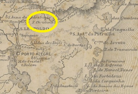
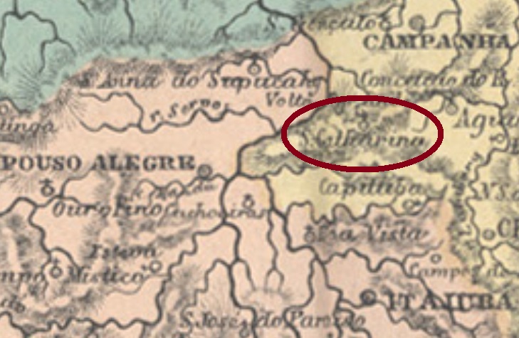
Santa Catharina, situated over 400 km southwest from the province capital Ouro Preto, was since May 1822 through royal license (Alvará Real) subordinated to Santa Rita do Sapucahy. In September 1923 it acquired the political independence as a municipality, which changed the toponym to Natércia in December 1953.
According to Paula Sobrinho (História Postal de Minas Gerais, Belo Horizonte, 1997), the local post office was created in October 1877, but operations started apparently only in the following year, as reported by the Rio press:
Gazeta de Noticias, Rio de Janeiro, March 20, 1878
Copies of the only known imperial cancel have dates between 1885 and 1890. SMG-2820a (Coll. José A. Junges) has a double circle with the inscriptions SANTA CATHARINA above and (MINAS) below. Dates in the centre.
Atlas do Imperio do Brasil, 1868
Der Distrikt von Santa Catharina lag über 400 km südwestlich von der Provinzhauptstadt Ouro Preto entfernt und war seit Mai 1822 durch königliche Verfügung (Alvará Real) Santa Rita do Sapucahy unterstellt. Im September 1923 stieg der Ort zu eigenem Município auf, der seit Dezember 1923 den Namen Natércia trägt.
Laut Paula Sobrinho (História Postal de Minas Gerais, Belo Horizonte, 1997) wurde das örtliche Postamt schon im Oktober 1877 ins Leben gerufen, dennoch startete der Betrieb scheinbar erst im darauf folgenden Jahr, wie die Presse aus Rio berichtet:
Gazeta de Noticias, Rio de Janeiro, 20. März, 1878
Vom einzig bekannten Stempel aus der Kaiserzeit gibt es Jahreszahlen zwischen 1885 und 1890. SMG-2820a (Samml. José A. Junges) hat einen Doppelkreis mit den Inschriften SANTA CATHARINA oben und (MINAS) unten. Die Daten sind in der Mitte.
Villiers de l’Ile Adam: Carta (…) da Provincia de São Paulo, 1847
Print version update, on October 19, 2021
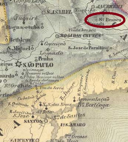
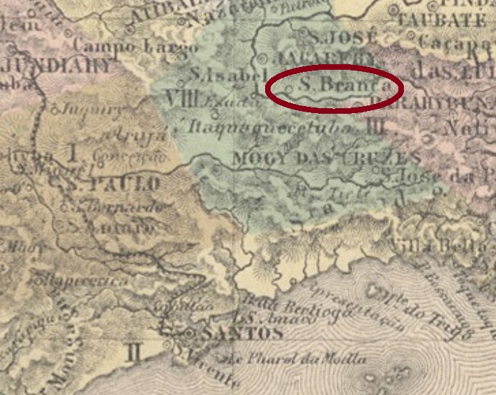
Santa Branca was since February 1841 a district of the municipality of Jacarehy, situated on the south bank of the Paraíba do Sul River, less than 100 km east of the province capital São Paulo. In March 1856 it ascended to a villa with own municipality.
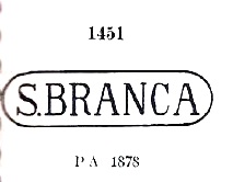
According to Nova Monteiro (Administrações e Agencias Postaes do Brasil Imperio, in Brasil Filatelico/RJ, 1934-5; Reprint SPP 1994-1999) the post office was created in August 1854. There is clearly a problem with the images of the earliest cancels from this village: Paulo Ayres (Catálogo de Carimbos Brasil- Império, S. Paulo, 1937, 1942) lists two of them under # 1451 and 1452. The first one was allegedly found from the 1878 emissions on (D. Pedro issue with white beard), the second from the 1866 emissions on (D. Pedro with black beard):
Paulo Ayres # 1451Paulo Ayres #1452
Indeed, the earliest examples found for this cancel were used already in the “numeral” issues (from 1850 on), and their images differ considerably from both Ayres’ examples. Here the best image found for SSP-1275a, which was found on stamps dated between 1854 and at least 1878 (image from Antonio Torres auctions):
SSP-1275a
The letter S and the following dot are quite different from both Paulo Ayres versions, else than further variations in letters and frame. Since we haven’t seen any example confirming either # 1451 or 1452 by P. Ayres, we can’t consider these images yet.
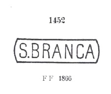
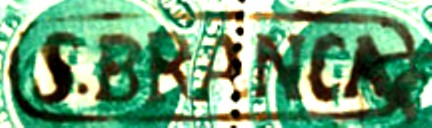
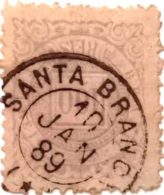
A second imperial cancel from Santa Branca, SSP-1275b (coll. José A. Junges), was found on pieces dated between 1882 and 1891. There is here a double circle with the inscription SANTA BRANCA above and the date in the centre. From the Fuad Ferreira Fo. collection comes a third cancel from there: SSP-1275c is a French type, which is reproduced here since it does not appear in Carimbologia S1:
SSP-1275c (FF), 1889Atlas do Imperio do Brasil,, 1868
Aktualisierung der Printausgabe am 19. Oktober 2021
Santa Branca war seit Februar 1841 ein Distrikt des Município von Jacarehy, der am Südufer des Flusses Paraíba do Sul, unter 100km östlich der Provinzhauptstadt São Paulo entfernt lag. Im März 1856 wurde daraus eine Villa im eigenen Município.
Laut Nova Monteiro (Administrações e Agencias Postaes do Brasil Imperio, in Brasil Filatelico/RJ, 1934-5; Reprint SPP 1994-1999) entstand das örtliche Postamt im August 1854. Es gibt allerdings ein Problem mit den ersten Stempeln dieser Ortschaft: Paulo Ayres (Catálogo de Carimbos Brasil-Império, S. Paulo, 1937, 1942) listet zwei davon unter den Nummern 1451 und 1452. Der erste wurde angeblich ab den Dom Pedro Ausgaben von 1878 (mit weißem Bart) gefunden, während Nr. 1452 ab den D. Pedro-Ausgaben v. 1866 (mit schwarzem Bart) einzutreffen ist:
P: Ayres Nr. 1451P. Ayres Nr. 1452
Tatsächlich wurden die frühen Beispiele dieses Stempels bereits ab den Numeral-Ausgaben (den so genannten Katzenaugen) gebraucht, und ihre Abbildungen weisen erhebliche Unterschiede gegenüber Ayres’ Beispielen auf. Hier die bisher deutlichste Abbildung von SSP-1275a , anzutreffen zwischen 1854 und mindestens 1878 (Abb. Alberto Torres Auktionen).
SSP-1275a (AT)
Die Buchstabe S und der darauf folgende Punkt sind deutlich anders, als von Ayres angegeben, abgesehen von weiteren Abweichungen in Buchstaben und Rahmen. So lange keine passenden Beispiele von Ayres Nr. 1451 oder 1452 auftauchen, bleiben beide Stempel fürs Erste außen vor.
Ein zweiter Santa Branca-Stempel aus der Kaiserzeit, SSP-1275b (Samml. José A. Junges) wurde auf Marken mit Daten zwischen 1882 und 1891 gefunden. Hier haben wir deinen Doppelkreis mit der Inschrift SANTA BRANCA oben und dem Datum in der Mitte. Aus der Sammlung Fuad Ferreira Fo. stammt ein dritter Stempel von dort: SSP-1275c ist ein französischer Typ, der hier abgebildet ist, da er nicht in Carimbologia S1 erschienen ist:
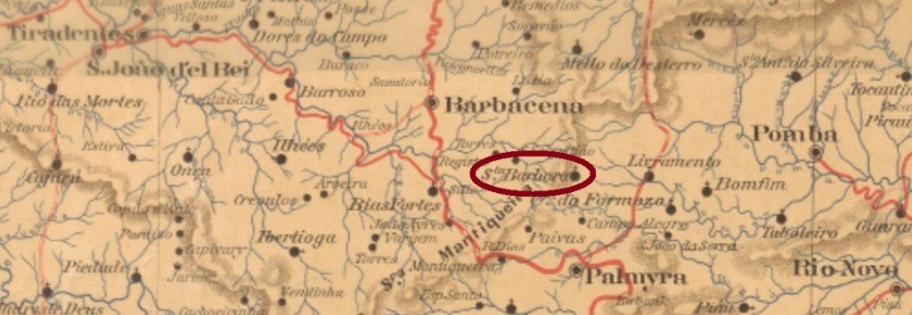
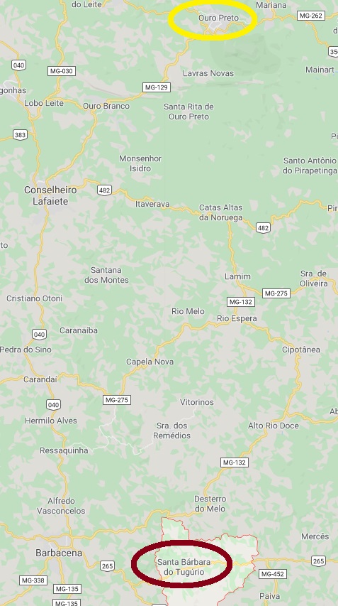
Tugúrio is neither a river nor a mountain, but rather an ancient Fazenda, which gave his name to the district of Santa Barbara, created in March 1839 in the municipality of Barbacena, over 150 km south of the province capital Ouro Preto. It was declared a Curato in November 1866, and was called Tugúrio from December 1938 until December 1962, when it ascended to the actual municipality of Santa Bárbara do Tugúrio.
According to Paula Sobrinho (História Postal de Minas Gerais, Belo Horizonte, 1997), the local post office was created in April 1885. One early cancel is known: SMG-2815a (Coll. Karlheinz Wittig) has a double circle with the inscriptions S.BARBARA DO TUGURIO above and (MINAS) below. Dates in the centre were found for the years 1890 and 1892.
Google Maps
Tugúrio ist weder ein Fluss noch ein Berg, aber so hieß eine Fazenda, die im März 1839 ihren Namen dem Distrikt von Santa Barbara im Município von Barbacena gab und über 150 km südlich der Provinzhauptstadt Ouro Preto entfernt lag. Im November 1866 wurde er zu einem Curato, und vom Dezember 1938 bis Dezember 1962 war sein Name zu Tugúrio vereinfacht. Dann wurde er zum aktuellen Município von Santa Bárbara do Tugúrio.
Laut Paula Sobrinho (História Postal de Minas Gerais, Belo Horizonte, 1997) gibt es dort ein Postamt seit April 1885. Ein einziger früher Stempel ist bekannt: SMG-2815a (Samml. Karlheinz Wittig) hat eine Doppelkreis mit den Inschriften S.BARBARA DO TUGURIO oben und (MINAS) unten. Die Daten in der Mitte weisen auf die Jahre 1890 und 1892 auf.
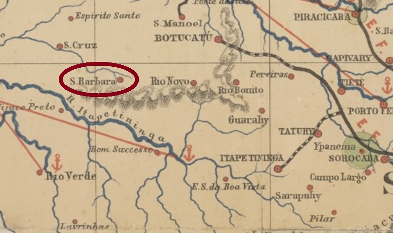
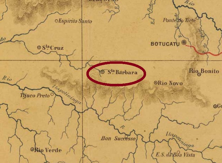
Santa Barbara do Rio Pardo is the ancient district of São Domingos, created in April 1858 in the municipality of Botucatu, near 300 km west of the province capital São Paulo. In June 1868 it switched to the municipality of Lençóis and acquired the political emancipation as the Villa de Santa Barbara in April 1876. In December 1906 it became a town, and since June 1978 it is called the municipality of Águas de Santa Bárbara.
According to the Imperial Mail Register (Tabella das Agencias do Correio do Imperio) of 1885, the local post office was created in 1877. Only one imperial cancel is known, dated 1890. SSP-1270a (Coll. José A. Junges) is a French-type and has a double circle with the inscription S.BARBARA DO RIO PARDO above and the typical star in parentheses below. The date is in the centre.
Joaquim M.R. Lisboa: Mappa da Provincia de São Paulo, 1884
Santa Barbara do Rio Pardo ist der ehemalige Distrikt von São Domingos, der im April 1858 im Município von Botucatu gegründet wurde und fast 300 km westlich der früheren Provinzhauptstadt São Paulo liegt. Im Juni 1868 wechselte der Distrikt zum Bezirk Lençóis, und im April 1876 wurde daraus die Villa de Santa Barbara. Im Dezember 1906 kam der Stadtstatus dazu, und seit Juni 1978 heißt dieser Município Águas de Santa Bárbara.
Laut dem Verzeichnis der kaiserlichen Postämter (Tabella das Agencias do Correio do Imperio) aus 1885 entstand 1877 das örtliche Postamt. Nur ein Stempel der Kaiserzeit ist überliefert, datiert 1890. SSP-1270a (Samml. José A. Junges) ist ein „französischer Typ“ und hat einen Doppelkreis mit der Inschrift S.BARBARA DO RIO PARDO oben und den typischen Stern in Klammern unten, dazu das Datum in der Mitte.