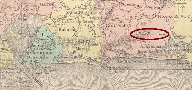
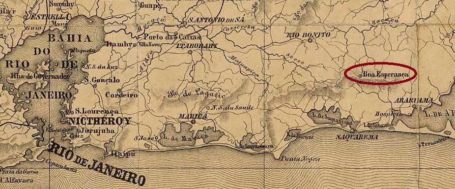
The curato (a parish with resident priest) of N. Sra. da Conceição da Boa Esperança was created in May 1849 in the Vila of Rio do Ouro (later Rio Bonito) and was 90 km east of the capital Rio de Janeiro. In September 1857, it became a freguesia, and in January 1891 a vila, only to return to Rio Bonito the following year, this time as a district. And so it has remained to this day, with the exception of the period from December 1943 to December 1950, when the district was called Imbiara.
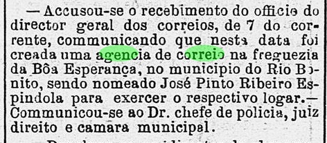
As can be read in the capital press, there was a post office there from December 1875:
Diario do Rio de Janeiro, 18.12.1875
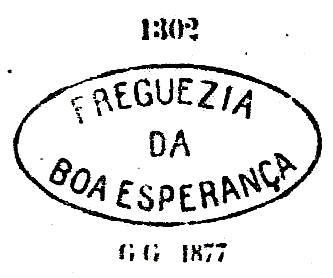
The first postmark BRJ-0180a also appears in blue and was used at least until 1877. It can be seen in Paulo Ayres’ Catálogo de Carimbos Brasil-Império (S. Paulo, 1937, 1942) under no. 1302:
BRJ-0180a (P.A. 1302)
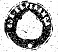
Reinhold Koester also mentions in Carimbologia IV a double circle cancel (BRJ-0180b) and shows a seal cancel (BRJ-0180c), unfortunately without further information:
BRJ-0180c (RK)Alamanak Laemmert, 1866
Anderer Name: Imbiara (1943-1950)
Der Curato (eine Pfarrei mit wohnhaftem Pfarrer) von N. Sra. da Conceição da Boa Esperança entstand im Mai 1849 in der Vila von Rio do Ouro (später Rio Bonito) und lag 90 km östlich der Hauptstadt Rio de Janeiro. Im September 1857 wurde daraus eine Freguesia, und im Januar 1891 eine Vila, nur um im darauffolgenden Jahr zu Rio Bonito zurückzukehren, diesmal als Distrikt. Und so ist es bis heute geblieben, mit Ausnahme des Zeitraums von Dezember 1943 bis Dezember 1950, als der Distrikt den Namen Imbiara trug.
Wie aus der Hauptstadtpresse hervorgeht, gab es dort ein Postamt seit Dezember 1875:
Diario do Rio de Janeiro, 18.12.1875
Der erste Poststempel BRJ-0180a kommt auch in blau vor und wurde mindestens bis 1877 gebraucht. Er ist im Paulo Ayres‘ Catálogo de Carimbos Brasil-Império, (S. Paulo, 1937, 1942) unter Nr. 1302 zu sehen:
BRJ-0180a (P.A. 1302)
Reinhold Koester erwähnt im Carimbologia IV auch einen Doppelkreisstempel (BRJ-0180b) und zeigt einen Siegelstempel (BRJ-0180c), leider ohne weitere Information:
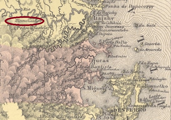
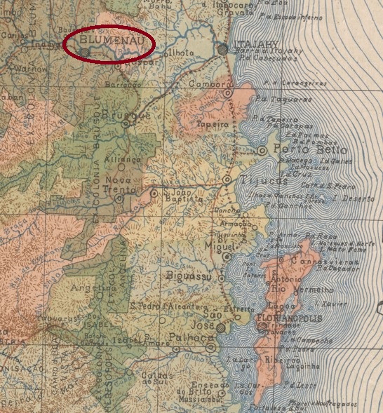
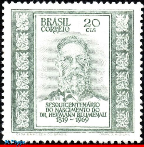
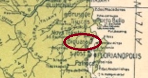
Since February 1850, this German colony existed on the south bank of the river Itajaí-Açu, 140 km northwest of the provincial capital Desterro (today: Florianópolis). The name comes from its founder, the German pharmacist and Doctor of Chemistry Hermann Blumenau (1819-1899), who returned to Germany in 1884 and died in Brunswick.
MiNo. 1242, RHM C-661
The town became a freguesia of the vila of Itajaí in July 1873, a vila in February 1880 and a town in July 1894, which today has over 350,000 inhabitants. Dr Blumenau could be proud of that.
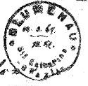
The local post office came into being in November 1874, as R. Koester wrote in Carimbologia IV. Three postmarks from the imperial period are shown in Paulo Ayres’ Catálogo de Carimbos Brasil-Império (S. Paulo, 1937, 1942). Of these, BSC-0025a is the oldest. It was used even before the opening of the post office, as it was in use from the postage-free colonist letters until at least 1876. Known through Paulo Ayres under no. 1560:
BSC-0025a (P.A. 1560) 1867-1876ff
Its successor BSC-0025b has been found so far with dates from 1877 to 1893:
BSC-0025b (P.A. p. 120)
Unfortunately, nothing is known about BSC-0025c:
BSC-0025c (P.A. p. 145)Estado de Santa Catharina, 1907
Seit Februar 1850 gab es die deutsche Kolonie am Südufer des Flusses Itajaí-Açu, 140 km nordwestlich der Provinzhauptstadt Desterro (heute: Florianópolis) entfernt. Der Name kommt von ihrem Gründer, dem deutschen Apotheker und Doktor der Chemie Hermann Blumenau (1819-1899), der 1884 nach Deutschland zurückkehrte und in Braunschweig starb.
MiNr. 1242, RHM C-661
Der Ort wurde im Juli 1873 zu einer Freguesia von der Villa von Itajaí, im Februar 1880 zur Vila und im Juli 1894 zur Stadt, die heute über 350.000 Einwohner hat. Da könnte Dr. Blumenau stolz sein.
Das örtliche Postamt entstand im November 1874, wie R. Koester in Carimbologia IV schrieb. Drei Poststempel aus der Kaiserzeit sind im Paulo Ayres‘ Catálogo de Carimbos Brasil-Império (S. Paulo, 1937, 1942) abgebildet. Davon ist BSC-0025a der älteste. Er wurde sogar vor der Postamteröffnung benutzt, da er seit der portofreien Kolonistenbriefen bis mindestens 1876 Verwendung fand. Bekannt durch Paulo Ayres unter Nr. 1560:
BSC-0025a (P.A. 1560) 1867-1876ff
Sein Nachfolger BSC-0025b wurde bisher mit Daten von 1877 bis 1893 gefunden:
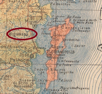
The history of this settlement is inseparable from that of the neighbouring municipality of São Miguel, as they alternated over the decades as the headquarters of the Vila or Município. When the settlement of S. João Evangelista da Foz do Biguassu came into being, it belonged to the Vila of S. Miguel and was located on the south bank of the mouth of the Biguassu River, 20 km northwest of the provincial capital Desterro (now Florianópolis). In August 1886, Biguassu became the headquarters of the vila of the same name. Two years later it was the other way round: Biguassu became a district of S. Miguel. And since 1894 Biguassu has been an independent Município.
There was already a post office in S. Miguel in about 1844, but it was not established in Biguassu until about 1886, although it is likely that the earlier S. Miguel postmarks were initially continued to be used in Biguassu.
The oldest Biguassu postmark in the Empire so far is BSC-0020a (image: Felipe Piccinini):
BSC-0020a (FP) ca. 1886
It was followed by BSC-0020b, which was shown by P. Ayres in Catálogo de Carimbos Brasil-Império (S. Paulo, 1937, 1942):
BSC-0020b (P.A. p. 145)
Its successor BSC-0020c (fig. from the internet) is probably already republican. In this double circle one reads BIGUASSÚ above, below is (S.CATHARINA). A specimen found, dated 1905 in the middle.
Arthur D. Ribeiro: Estado de Santa Catharina, 1923
Textaktualisierung am 4. März 2024
Die Geschichte dieser Ortschaft ist untrennbar mit der von der Nachbargemeinde São Miguel verbunden, da sie sich im Laufe der Jahrzehnte als Hauptsitz der Vila bzw. Município abwechselten. Als die Siedlung von S. João Evangelista da Foz do Biguassu entstanden ist, gehörte sie der Vila von S. Miguel und lag am Südufer der Mündung des Flusses Biguassu, 20 km nordwestlich der Provinzhauptstadt Desterro (heute Florianópolis). Im August 1886 wurde Biguassu Hauptsitz der gleichnamigen Vila. Zwei Jahre später war es umgekehrt: Biguassu wurde ein Distrikt von S. Miguel. Und seit 1894 ist Biguassu ein eigenständiger Município.
Ein Postamt in S. Miguel gab es schon ca. 1844, aber in Biguassu wurde es erst ca. 1886 ins Leben gerufen, wobei wahrscheinlich ist, dass zunächst die früheren S- Miguel-Poststempel in Biguassu weiterverwendet wurden.
Der bisher älteste Biguassu-Poststempel im Kaiserreich ist BSC-0020a (Abb. Felipe Piccinini):
Sein Nachfolger BSC-0020c (Abb. aus dem Internet) dürfte bereits republikanisch sein. In diesem Doppelkreis liest man BIGUASSÚ oben, unten steht (S.CATHARINA). Ein Exemplar gefunden, datiert 1905 in der Mitte.
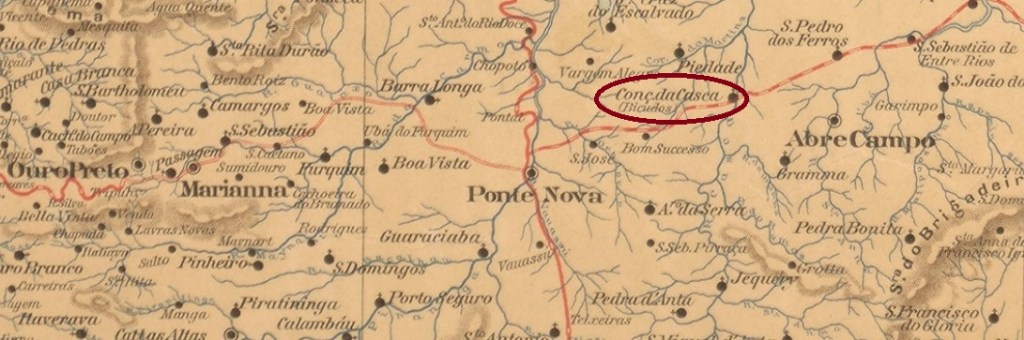
The settlement with the peculiar name Bicudos (Long Beaks) – supposedly an allusion to the long noses of the first colonist family – came into being around 1842 and was located directly on the Casca River in the município of Ponte Nova, 120 km east of the provincial capital Ouro Preto. The place rose to the status of freguesia in May 1858 and attained the status of município in August 1911.
Reinhold Koester (Carimbologia IV) gives October 1879 as the date of origin of the local post office, which is confirmed by the 1885 Directory of Imperial Post Offices (Tabella das Agencias do Correio do Império). Paula Sobrinho, on the other hand, writes that the post office was created in October 1878, which is probably a typing error.
Koester (op. cit.) also presented a cancellation by hand, with the inscription Bicudos and the date May 1885:
1885 (RK)
Later postal cancellations bear the place name CONCEIÇÃO DO CASCA or RIO CASCA.
Estado de Minas Geraes, 1910
Andere Namen: Conceição do Casca, Rio Casca
Siehe auch: Rio Casca (RMG-2115)
Die Siedlung mit dem eigentümlichen Namen Bicudos (Langschnäbel) – angeblich als Anspielung auf die langen Nasen der ersten Kolonistenfamilie – entstand um 1842 und lag direkt am Fluss Casca im Município von Ponte Nova, 120 km östlich der Provinzhauptstadt Ouro Preto. Der Ort stieg im Mai 1858 zur Freguesia und erlangte den Status eines Município im August 1911.
Reinhold Koester (Carimbologia IV) nennt als Entstehungsdatum fürs örtliche Postamt den Oktober 1879, was vom Verzeichnis der kaiserlichen Postämter (Tabella das Agencias do Correio do Império) von 1885 bestätigt wird. Paula Sobrinho schreibt andererseits, das Postamt sei im Oktober 1878 entstanden, was wohl ein Tippfehler ist.
Koester (op. cit.) präsentierte auch eine Entwertung per Hand, mit der Inschrift Bicudos und dem Datum Mai 1885:
1885 (RK)
Spätere postalische Entwertungen tragen die Ortsbezeichnung CONCEIÇÃO DO CASCA oder RIO CASCA
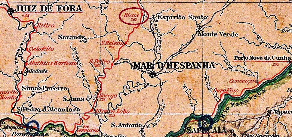
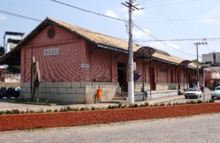
The beautiful Portuguese word Bica means a natural watering place that quenches the thirst of humans and animals. Bicas station was inaugurated in September 1879 by the railway company Cia. União Mineira (Main Line) and was in the Município of Mar d’Hespanha, 260 km south of the provincial capital Ouro Preto. In 1884, the railway line went to E.F. Leopoldina and belonged to Rede Ferroviaria Federal S.A. from 1975 until its closure in 1996 (estacoesferroviarias.com.br). Today, although the rails are gone, the old station building has been restored and serves as a bus station.
ca. 1940 (estacoesferroviarias.com.br)2008 (Photo: Jorge A. Ferreira in estacoesferroviarias.com.br)
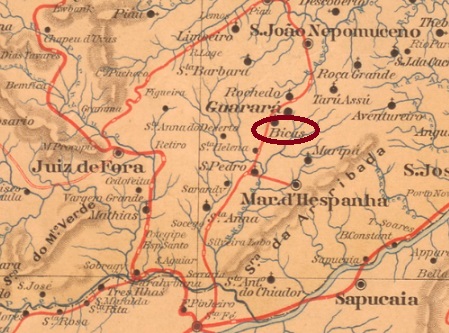
The settlement around the railway station grew rapidly, becoming a district in September 1890, which subsequently changed to the Município of Guarará, and has been the Município of Bicas since September 1925.
Here, too, we have two dates of origin for the local post office. First in 1879, as listed in the Directory of Imperial Post Offices (Tabella das Agencias do Correio do Imperio, Rio de Janeiro, 1885). Then in July 1881, as listed in the postal report (Relatorio Postal) of 1886.
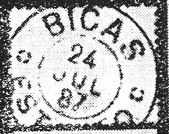
The first railway station postmark BMG-0290a has now been presented by the philatelist Guilherme Kühner:
BMG-0290a (GK) 1879ff
It was followed by BMG-0290b, described by R. Koester in Carimbologia IV as follows: a plain double circle without ornament at the bottom, the only specimen dated 1883 in the centre. The following double circle BMG-0290c (illustration from the internet) has the inscriptions BICAS at the top and (ESTAÇÃO) at the bottom, with inner dates from 1885 to 1886. And the third double circle BMG-0290d was also presented by R. Koester (op. cit.):
BMG-0290d (RK) 1886-1898
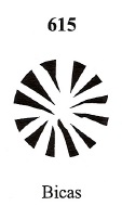
From this station post office also comes a mute cancellation, assigned no. 615 by James Dingler and Klerman W. Lopes in Mute Cancellations of the Brazil Empire / Carimbos Mudos do Brasil Império (Brazil Philatelic Association, Rio de Janeiro, 2000). This is identical with no. 82 in Paulo Ayres’ Catálogo de Carimbos Brasil-Império (S. Paulo, 1937, 1942):
BPA 615 (P.A. 82) 1878ffEstado de Minas Geraes, 1910
Textaktualisierung vom 18.10.2024
Das schöne portugiesische Wort Bica bedeutet eine natürliche Wasserstelle, die den Durst von Mensch und Tier stillt. Der Bahnhof Bicas wurde im September 1879 durch die Bahngesellschaft Cia. União Mineira (Hauptlinie) eingeweiht und lag im Município von Mar d’Hespanha, 260 km südlich der Provinzhauptstadt Ouro Preto entfernt. 1884 ging die Bahnlinie zur E.F. Leopoldina und gehörte von 1975 bis zur Stilllegung 1996 der Rede Ferroviaria Federal S.A. (estacoesferroviarias.com.br). Heute sind zwar die Schienen weg, das alte Bahnhofsgebäude wurde restauriert und dient als Busbahnhof.
ca. 1940 (estacoesferroviarias.com.br)2008 (Foto: Jorge A. Ferreira in estacoesferroviarias.com.br)
Die Siedlung um den Bahnhof wuchs schnell, sie wurde im September 1890 ein Distrikt, der anschließend zum Município von Guarará wechselte, und gehört seit September 1925 zum Município von Bicas.
Auch hier haben wir zwei Entstehungsdaten fürs örtliche Postamt. Erstmals 1879, wie im Verzeichnis der kaiserlichen Postämter (Tabella das Agencias do Correio do Imperio, Rio de Janeiro, 1885) aufgelistet. Dann im Juli 1881, wie im Postbericht (Relatorio Postal) von 1886 zu lesen ist.
Der erste Bahnhofspoststempel BMG-0290a wurde inzwischen durch den Philatelisten Guilherme Kühner vorgestellt:
BMG-0290a (GK) 1879ff
Sein Nachfolger BMG-0290b wurde von R. Koester in Carimbologia IV wie folgt beschrieben: ein schlichter Doppelkreis ohne Ornament unten, das einzige Exemplar 1883 in der Mitte datiert. Der folgende Doppelkreis BMG-0290c (Abbildung aus dem Internet) hat die Inschriften BICAS oben und (ESTAÇÃO) unten, mit inneren Daten von 1885 bis 1886. Und der dritte Doppelkreis BMG-0290d wurde ebenfalls durch R. Koester (op. cit.) vorgestellt:
BMG-0290d (RK) 1886-1898
Aus diesem Bahnhofspostamt kommt auch eine stumme Abstempelung, die von James Dingler und Klerman W. Lopes in Mute Cancellations of the Brazil Empire / Carimbos Mudos do Brasil Império (Brazil Philatelic Association, Rio de Janeiro, 2000) mit Nr. 615 versehen wurde. Diese ist identisch mit Nr. 82 in Paulo Ayres’ Catálogo de Carimbos Brasil-Império (S. Paulo, 1937, 1942):
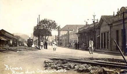
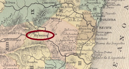
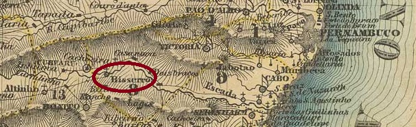
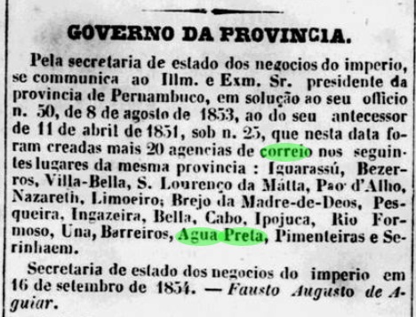
The Freguesia of S. José dos Bezerros was created in November 1805, belonged to the Vila of Bonito and was located on the south bank of the river Ipojuca, 100 km west of the provincial capital Recife. In May 1870, the village became a vila and eleven years later a town.
Two dates of origin for the local post office have been reported. The first one was in September 1854, as stated in the regional press:
Diario de Pernambuco, 07.10.1854
The second date is in August 1855, as Nova Monteiro writes in Administrações e Agencias Postaes do Brasil Imperio (Brasil Filatelico/RJ, 1934-5; Reprint SPP 1994-1999). This could possibly be the time when the postal agency was put into operation.
So far, only one postmark from the imperial period has been found: BPE-0100b occurs with dates from about 1882 until after 1888 and was already presented by R. Koestner in Carimbologia IV:
BPE-0100b (RK) 1882-1888ffVilliers de l’Ile Adam: Carta (…) das Provincias de Pernambuco, Alagoas e Sergipe, 1848
Die Freguesia von S. José dos Bezerros wurde im November 1805 ins Leben gerufen, gehörte der Vila von Bonito und lag am Südufer des Flusses Ipojuca, 100 km westlich der Provinzhauptstadt Recife entfernt. Im Mai 1870 wurde aus der Ortschaft eine Vila und elf Jahre später eine Stadt.
Zwei Entstehungstermine fürs örtliche Postamt wurden gefunden. Erstmals im September 1854, wie die Regionalpresse berichtete:
Diario de Pernambuco, 07.10.1854
Der zweite Termin soll im August 1855 stattgefunden haben, wie Nova Monteiro in Administrações e Agencias Postaes do Brasil Imperio (Brasil Filatelico/RJ, 1934-5; Reprint SPP 1994-1999) schreibt. Dieser könnte evtl. der Zeitpunkt der Inbetriebnahme der Postagentur sein.
Bisher wurde nur ein Poststempel aus der Kaiserzeit gefunden: BPE-0100b kommt mit Daten von ca. 1882 bis nach 1888 vor und wurde bereits durch R. Koestner in Carimbologia IV vorgestellt:
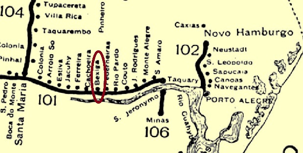
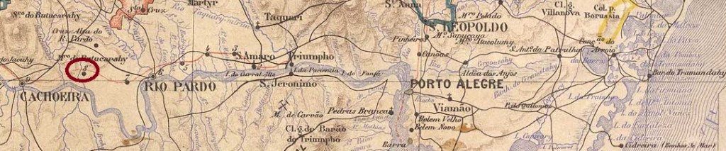
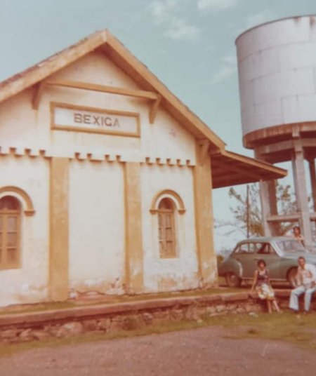
Bexiga (Bladder) station was inaugurated in March 1883 by the E.F. Porto Alegre a Uruguayana company (Main Line) and was located on the stream of the same name in the Município of Rio Pardo, 180 km west of the provincial capital Porto Alegre. The railway line went to the Cie. Auxiliaire de Chemins de Fer au Brésil in 1898, to the Viação Férrea Rio Grande do Sul in 1920 and belonged to Rede Ferroviária Federal S.A. from 1975 until its closure in 1996 (estacoesferroviárias.com.br). The station area belonged to the newly founded district of Cruz Alta (not to be confused with the town of the same name) from January 1898 and has been in the district of Bexiga since about 1940. Today, the rails are still there, but the old station was not located.
ca. 1970 (estacoesferroviarias.com.br)
The station post office came into being in September 1889, as can be read in the postal bulletin (Boletim Postal) of the following month:
Boletim Postal #6/Oct 89
The oldest postmark so far, BRS-0030a (image from the internet), has dates from 1891 to 1901 and could therefore not be the first. This double circle reads BEXIGA at the top, while at the bottom it reads (R.G. DO SUL), an indication of republican origin.
Estado do Rio Grande do Sul, 1891
Textaktualisierung vom 20. April 2023
Der Bahnhof Bexiga (Blase) wurde im März 1883 durch die Gesellschaft E.F. Porto Alegre a Uruguayana (Hauptlinie) eingeweiht und lag am gleichnamigen Bach im Município von Rio Pardo, 180 km westlich der Provinzhauptstadt Porto Alegre entfernt. Die Bahnlinie ging 1898 an die Cie. Auxiliaire de Chemins de Fer au Brésil, 1920 an die Viação Férrea Rio Grande do Sul und gehörte von 1975 bis zur Stilllegung 1996 der Rede Ferroviária Federal S.A. (estacoesferroviárias.com.br). Das Bahnhofsareal gehörte ab Januar 1898 dem neu gegründeten Distrikt von Cruz Alta (nicht mit der gleichnamigen Stadt zu verwechseln) und steht seit ca. 1940 im Distrikt Bexiga. Heute sind die Schienen noch da, aber der alte Bahnhof nicht auffindbar.
ca. 1970 (estacoesferroviarias.com.br)
Das Bahnhofspostamt entstand im September 1889, wie im Postbulletin (Boletim Postal) des darauffolgenden Monats zu lesen ist:
Boletim Postal 6/89
Der bisher älteste Poststempel BRS-0030a (Abb. aus dem Internet) hat Daten von 1891 bis 1901 und könnte dadurch nicht der erste sein. In diesem Doppelkreis liest man BEXIGA oben, während unten (R.G. DO SUL) steht, ein Indiz für republikanischen Ursprung.
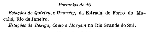
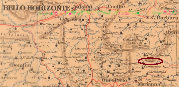
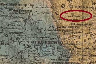
The settlement called N. Senhora da Conceição de Bento Rodrigues originated around 1844 near the Vila of Mariana and was located 40 km north of the provincial capital Ouro Preto. In November 1880, it became a freguesia, but did not grow any further. Until 2015, Bento Rodrigues was a hamlet in the district of Sta. Rita Durão, then it was destroyed by a dam burst and is to be rebuilt 9 km further on.
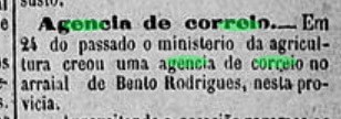
Two dates have been found for the origin of the local post office. The first one was in March 1881, according to the regional press:
O Baependyano/03.04.1881
The second post office opening took place in April 1892 in the early Republic, as can be read in the postal bulletin (Boletim Postal) of that year. The imperial postmark is BMG-0285a and has already been shown by R. Koester in Carimbologia IV:
BMG-0285a (RK) 1885Villiers de l’Ile Adam: Carta (…) da Provincia de Minas Geraes, 1849
Die Siedlung namens N. Senhora da Conceição de Bento Rodrigues entstand um 1844 bei der Vila von Mariana und lag 40 km nördlich der Provinzhauptstadt Ouro Preto entfernt. Im November 1880 wurde daraus eine Freguesia, die aber nicht weitergewachsen ist. Bis 2015 war Bento Rodrigues ein Ortsteil im Distrikt von Sta. Rita Durão, dann wurde es durch einen Staudammbruch komplett zerstört und soll 9 km weiter wieder aufgebaut werden.
Es wurden zwei Daten für die Entstehung des örtlichen Postamts gefunden. Erstmals im März 1881, wie aus der Regionalpresse hervorgeht:
O Baependyano/03.04.1881
Die zweite Postamteröffnung fand im April 1892 in der frühen Republik statt, wie man im Postbulletin (Boletim Postal) dieses Jahres lesen kann. Der kaiserliche Poststempel ist BMG-0285a und wurde bereits durch R. Koester in Carimbologia IV gezeigt:
Carta da Republica dos Estados Unidos do Brazil, 1892
Another name: São Miguel Archanjo
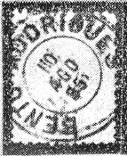
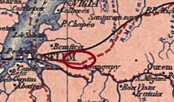
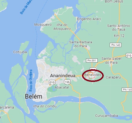
This village was an agricultural colony (Colonia Agrícola) from June 1875, founded by the provincial governor Francisco de Sá e Benevides (1846-1896) and located 35 km east of the provincial capital Belém do Pará. Three years later, the Arraial was officially renamed São Miguel Archanjo, but there is much to suggest that the old place name Benevides remained in circulation even then. Even before 1890, Benevides became a district in the Município of Belém; the district changed to the Município of Ananindeua in December 1843. Since December 1961, Benevides has been an independent Município.
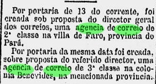
As the Rio press reported, there was a post office there since January 1882:
Gazeta de Noticias/RJ, 14/01/1882
The imperial postmark is BPA-0046a (coll. Jorge L. Pedreira): this double circle imitates a French type without following its dimensions. At the top you read BENEVIDES, at the bottom there is a star between brackets. The only specimen so far is dated 1886 in the centre.
Google Maps
Anderer Name: São Miguel Archanjo
Diese Ortschaft war ab Juni 1875 eine Landwirtschaftskolonie (Colonia Agrícola), die durch den Provinzgouverneur Francisco de Sá e Benevides (1846-1896) gegründet wurde und 35 km östlich der Provinzhauptstadt Belém do Pará lag. Drei Jahre später wurde der Arraial offiziell zu São Miguel Archanjo umbenannt, aber vieles spricht dafür, dass der alte Ortsname Benevides auch dann im Umlauf blieb. Noch vor 1890 wurde Benevides ein Distrikt im Município von Belém; der Distrikt wechselte im Dezember 1843 zum Município von Ananindeua. Seit Dezember 1961 ist Benevides ein eigenständiger Município.
Wie die Presse aus Rio meldete, gab es dort ein Postamt seit Januar 1882:
Gazeta de Noticias/RJ, 14.01.1882
Der kaiserliche Poststempel ist BPA-0046a (Samml Jorge L. Pedreira): dieser Doppelkreis ahmt einen französischen Typus nach, ohne dessen Maßen zu folgen. Oben liest man BENEVIDES, unten ist ein Stern zwischen Klammern. Das bisher einzige Exemplar ist 1886 in der Mitte datiert.
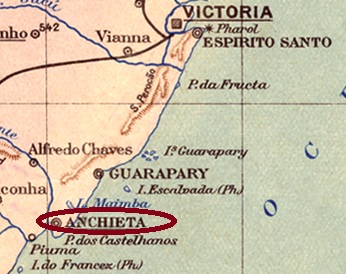
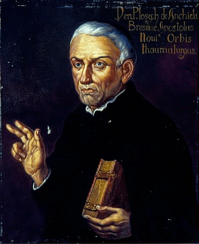
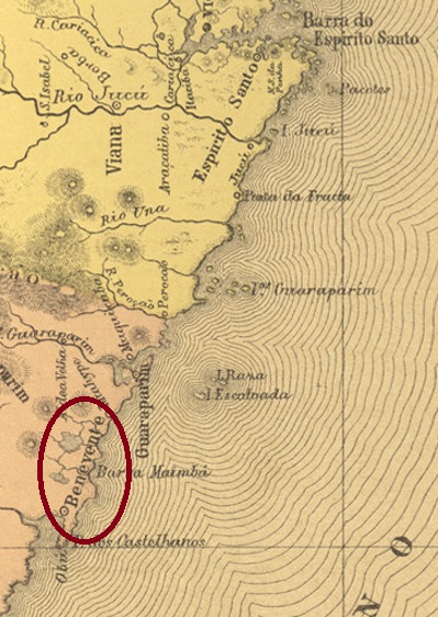
This settlement, which is very old by Brazilian standards, was established around 1570 on the delta of the Benevente River, 80 km south of the later provincial capital Vitória. The original place name was Reritiba, which means many oysters in the Tupi language. In January 1759, the Vila of N. Sra. da Assumpção de Benevente was proclaimed there, which has been the town of Anchieta since August 1887, but this name apparently took a long time to catch on. This is to commemorate the Spanish Father José de Anchieta (1534-1597), who is buried there and has been a saint of the Catholic Church since 2014:
Painting by Oscar P. da Silva (1867-1939), Museu Paulista da USP
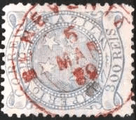
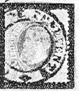
The local post office was established in October 1831, when the town was still called Benevente, as Nova Monteiro writes in Administrações e Agencias Postaes do Brasil Imperio (Brasil Filatelico/RJ, 1934-5; reprint SPP 1994-1999). The first postmark has not yet been found, the second is BES-0195b and has already been shown by. R. Koester in Carimbologia IV:
BES-0195b (RK) 1883ff-1884ff
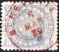
It was followed by BES-0195c (fig. from the internet) A double circle with the inscription BENEVENTE on top, which also exists in red, and which shows inner dates between 1886 and 1889.
BES-0195c (image from the internetB)
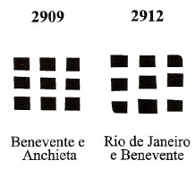
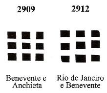
Ttwo mute postmarks were also used, which are registered in the Mute Cancellations of the Brazil Empire / Carimbos Mudos do Brasil Império (Brazil Philatelic Association, Rio de Janeiro, 2000) under nos. 2909 and 2912:
BPA 2909 and 2912
For postmarks with Anchieta see AES-0020.
Atlas do Imperio do Brasil, 1868
Andere Namen: Reritiba, Anchieta
Siehe auch Anchieta (AES-0020)
Diese für brasilianische Verhältnisse sehr alte Siedlung entstand bereits um 1570 am Delta des Flusses Benevente, 80 km südlich der späteren Provinzhauptstadt Vitória entfernt. Der erste Ortsname war Reritiba, was in der Tupi-Sprache viele Austern bedeutet. Im Januar 1759 wurde dort die Vila von N. Sra. da Assumpção de Benevente ausgerufen, die seit August 1887 zwar die Stadt Anchieta ist, aber dieser Name hat offenbar lange gebraucht, um sich durchzusetzen. Damit soll an den spanischen Pater José de Anchieta (1534-1597) erinnert, der dort begraben liegt und seit 2014 ein Heiliger der katholischen Kirche ist:
Gemälde v. Oscar P. da Silva (1867-1939), Museu Paulista da USP
Das örtliche Postamt entstand im Oktober 1831, als der Ort noch Benevente hieß, wie Nova Monteiro in Administrações e Agencias Postaes do Brasil Imperio (Brasil Filatelico/RJ, 1934-5; Reprint SPP 1994-1999) schreibt. Der erste Poststempel wurde noch nicht gefunden, der zweite ist BES-0195b und wurde bereits durch. R. Koester in Carimbologia IV gezeigt:
BES-0195b (RK) 1883ff-1884ff
Ihm folgte BES-0195c (Abb. aus dem Internet) Ein Doppelkreis mit der Inschrift BENEVENTE oben, den es auch in rot gibt, und der inneren Daten zwischen 1886 und 1889 aufweist.
BES-0195c (Abb. aus dem Internet)
Zwei stumme Poststempel wurden auch gebraucht, die im Mute Cancellations of the Brazil Empire / Carimbos Mudos do Brasil Império (Brazil Philatelic Association, Rio de Janeiro, 2000) unter den Nr. 2909 und 29129 registriert sind:
BPA 2909 und 2912
Für kaiserliche Poststempel mit Anchieta siehe AES-0020.