Categories
Carimbologia M-N

Mello Barreto (train station/Bahnhof), Minas Gerais (MMG-1590)

Almanak Laemmert, 1892

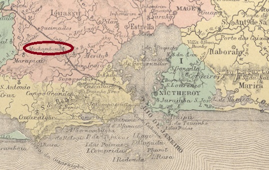
Other names: Entroncamento

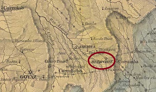
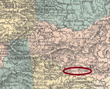
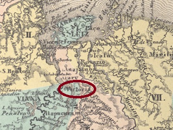
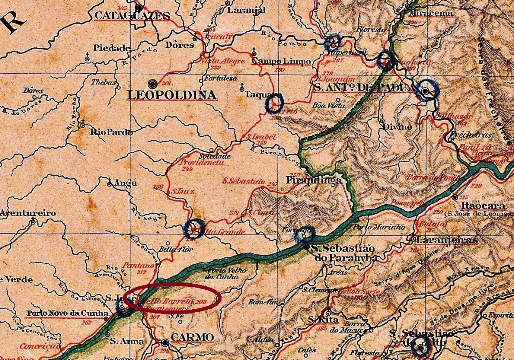
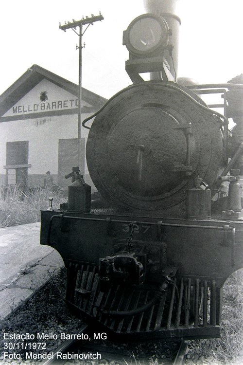
Mello Barreto Station was opened in April 1887 by the E. F. Leopoldina railway company (Main Line) on the north bank of the Paraíba do Sul in the municipality of Além Paraíba. It was located 300 km southeast of the provincial capital Ouro Preto. Antonio Paulo de Mello Barreto (1839-1908) was a director of Leopoldina. Ralph Giesbrecht writes on his website estacoesferroviarias.com.br that the station used to be called ‘Entroncamento’ (junction) because the branch line to Sumidouro in the province of Rio de Janeiro started from there. The railway line belonged to Rede Ferroviaria Federal S.A. from 1975 until it was decommissioned in 1996. Today, the tracks are still there, but the station building has already been demolished.

In November 1972 (photo: Mendel Rabinovitch, on estacoesferroviarias.com.br)
In July 2007 (photo: Ricardo Quinteiro de Mattos, on estacoesferroviarias.com.br)

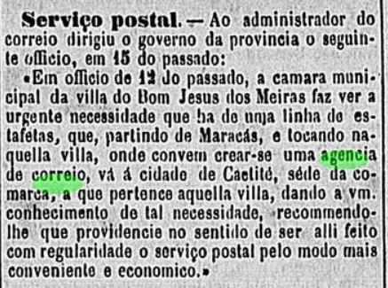
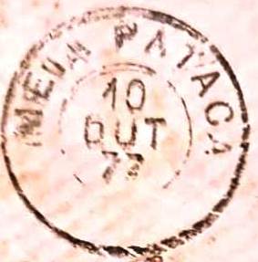
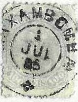
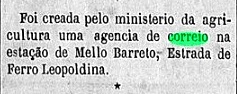
Both Paula Sobrinho (História Postal de Minas Gerais, Belo Horizonte, 1997) and R. Koester (Carimbologia XXVII) write that there had been a post office there since February 1888. This is confirmed by the Rio press:

Gazeta Nacional/RJ, 17 February 1888

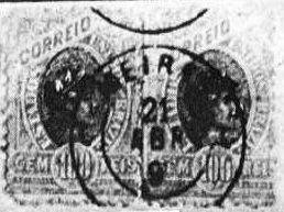
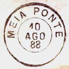
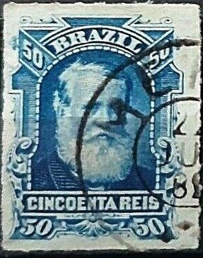
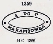
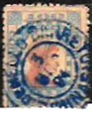
The imperial postmark is MMG-1590a (Fig. Filatélica Minas Gerais), which is also available in blue:

MMG-1590a (FMG) 1888-1891
Amarildo Mayrink: E. F. Leopoldina

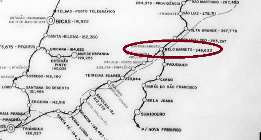
Andere Namen: Entroncamento

Der Bahnhof Mello Barreto wurde im April 1887 durch die Eisenbahngesellschaft E. F. Leopoldina (Hauptlinie) am Nordufer des Paraíba do Sul im Município de Além Paraíba eröffnet. Er lag 300 km südöstlich der Provinzhauptstadt Ouro Preto. Antonio Paulo de Mello Barreto (1839-1908) war ein Direktor der Leopoldina. Ralph Giesbrecht schreibt auf seiner Website estacoesferroviarias.com.br, dass der Bahnhof früher „Entroncamento” (Abzweigung) hieß, da von dort aus die Nebenlinie nach Sumidouro in der Provinz Rio de Janeiro startete. Die Bahnlinie gehörte von 1975 bis zur Stilllegung im Jahr 1996 der Rede Ferroviaria Federal S.A. Heute sind die Gleise noch vorhanden, das Bahnhofsgebäude wurde jedoch bereits abgerissen.

Im November 1972 (Foto: Mendel Rabinovitch, auf estacoesferroviarias.com.br)
Im Juli 2007 (Foto: Ricardo Quinteiro de Mattos, auf estacoesferroviarias.com.br)

Sowohl Paula Sobrinho (História Postal de Minas Gerais, Belo Horizonte, 1997) als auch R. Koester (Carimbologia XXVII) schreiben, dass es dort seit Februar 1888 ein Postamt gab. Dies wird durch die Presse von Rio bestätigt:

Gazeta Nacional/RJ, 17.02.1888

Der kaiserliche Poststempel ist MMG-1590a (Abb. Filatélica Minas Gerais), den es auch in Blau gibt:

MMG-1590a (FMG) 1888-1891
Categories
Carimbologia M-N

Melgaço, Pará (MPA-0160)

Villiers de l’Ile Adam: Carta (…) das Provincias do Grão-Pará e Alto Amazonas, 1850

Other names: Arycuru

The former settlement of Arycuru was located on the western shore of what is now Melgaço Bay, 250 kilometres west of the later provincial capital Belém do Pará.

In 1758, it was elevated to the status of Vila de Melgaço, named after a town on the Upper Minho in Portugal, which had a population of 1,560 in 2011. In January 1851, it was designated Freguesia de São Miguel de Melgaço in the territory of Vila de Breves. In August 1856, Melgaço became an independent vila. In November 1930, Melgaço was downgraded to a district, but in December 1961 it was again designated a município.

We do not know when the local post office was opened, but it was in operation by 1877 at the latest, as evidenced by the provincial president’s report from February 1881:

Relatorio do Presidente da Provincia, February 1881

No imperial postmark from Melgaço in the province of Pará has been seen to date.

Atlas do Imperio do Brasil, 1868

Andere Namen: Arycuru

Die ehemalige Siedlung Arycuru lag am Westufer der heutigen Bucht von Melgaço, 250 Kilometer westlich der späteren Provinzhauptstadt Belém do Pará.

Im Jahr 1758 wurde sie zur Vila de Melgaço erhoben, benannt nach einer Ortschaft am Oberen Minho in Portugal, die im Jahr 2011 1.560 Einwohner zählte. Im Januar 1851 erfolgte die Ernennung zur Freguesia de São Miguel de Melgaço im Gebiet der Vila de Breves. Im August 1856 wurde Melgaço eine eigenständige Vila. Im November 1930 wurde Melgaço zum Distrikt herabgestuft, im Dezember 1961 jedoch wieder zum Município ernannt.

Wir wissen nicht, wann das örtliche Postamt eröffnet wurde; es war jedoch spätestens 1877 in Betrieb, wie aus dem Bericht des Provinzpräsidenten vom Februar 1881 hervorgeht:

Relatorio do Presidente da Provincia, Februar 1881

Bisher wurde kein kaiserlicher Poststempel aus Melgaço in der Provinz Pará gesehen.

Categories
Carimbologia M-N

Meiras, Bahia (MBA-0145)

Estado da Bahia, 1913

See also Bom Jesus dos Meiras (BBA-0145)

The Freguesia of Senhor Bom Jesus dos Meiras came into being in June 1869 and has its origin in the fazenda called Senhor Bom Jesus do Campo Seco, of the landowner Francisco de Sousa Meira. It was located on the west bank of the Rio do Antonio (a tributary of the Brumado) near the Vila of Caetité, 540 km southwest of the provincial capital Salvador da Bahia. The village rose to the status of Vila in June 1877 and has been the Município of Brumado since June 1931.

Two dates of origin for the local post office were found. Reinhold Koester (Carimbologia V) writes October 1872 for it, while in the Directory of Imperial Post Offices (Tabella das Agencias do Correio do Imperio, Rio de Janeiro, 1885) the year 1878 can be read. A note in the regional press indicates that in July 1878 there was still no post office in operation locally:

Correio da Bahia, 02.08.1878

The imperial postmark from this locality is MBA-0145a (Fig. Koester, in Carimbologia XXVII):

MBA-0145a (RK) 1887-1894ff
Carta da Republica dos Eestados Unidos do Brazil, 1892

Siehe auch Bom Jesus dos Meiras (BBA-0145)

Die Freguesia von Senhor Bom Jesus dos Meiras entstand im Juni 1869 und hat ihren Ursprung in der Fazenda namens Senhor Bom Jesus do Campo Seco, des Großgrundbesitzers Francisco de Sousa Meira. Sie lag am Westufer des Rio do Antonio (ein Nebenfluss des Brumado) bei der Vila von Caetité, 540 km südwestlich der Provinzhauptstadt Salvador da Bahia. Der Ort stieg im Juni 1877 zur Vila auf und ist seit Juni 1931 der Município von Brumado.

Zwei Entstehungsdaten fürs örtliche Postamt wurden gefunden. Reinhold Koester (Carimbologia V) schreibt dafür den Oktober 1872, während im Verzeichnis der kaiserlichen Postämter (Tabella das Agencias do Correio do Imperio, Rio de Janeiro, 1885)das Jahr 1878 zu lesen ist. Eine Meldung der Regionalpresse deutet darauf hin, dass im Juli 1878 noch kein Postamt vor Ort in Betrieb war:

Correio da Bahia, 02.08.1878

Der kaiserliche Poststempel aus dieser Ortschaft ist MBA-0145a (Abb. Koester, in Carimbologia XXVII):

MBA-0145a (RK) 1887-1894ff

Categories
Carimbologia M-N

Meia Ponte, Goiás (MGO-0250)

Villiers de l’Ile Adam: Carta (…) da Provincia de Goyaz, 1849

Other names: Pyrenopolis/Pirenópolis

The settlement of Minas de N. Sra. do Rosário de Meia Ponte existed since 1727 on the south bank of the Rio das Almas, 150 km east of the later provincial capital Goyaz (today Goiás Velho). In 1754, it was elevated to the status of a parish, in July 1832 to a village, and finally in August 1853 to a town. Since February 1890, it has been known as Pirenópolis. According to tradition, the name ‘Meia Ponte’ (Half Bridge) dates back to a flood on the Rio das Almas, which partially destroyed the bridge. The name Pirenópolis refers to the nearby mountain range, which resembles the Pyrenees.

According to Nova Monteiro, there has been a post office there since March 1829, as described in Administrações e Agencias Postaes do Brasil Imperio (Brasil Filatelico/RJ, 1934–1935; reprinted SPP 1994–1999). However, the directory of imperial post offices (Tabella das Agencias do Correio do Imperio, Rio de Janeiro, 1885) indicates the year 1832 for that. The oldest postmark to date is MGO-0250a, which was given the number 1360 by P. Ayres in Catálogo de Carimbos Brasil-Império (S. Paulo, 1937, 1942), shown here in an illustration from the Silvio A. Canani collection:

MGO-0250a (P.A. 1360 – SiCa) 1843ff-1866ff

This was followed by the double circle MGO-0250b (Fuad Ferreira Fo. collection).

MGO-0250b (FF) 1879-1888
Atlas do Imperio do Brasil, 1868

Andere Namen: Pyrenopolis/Pirenópolis

Die Siedlung Minas de N. Sra. do Rosário de Meia Ponte bestand seit 1727 am Südufer des Rio das Almas, 150 km östlich der späteren Provinzhauptstadt Goyaz (heute Goiás Velho). Im Jahr 1754 wurde sie zur Freguesia, im Juli 1832 zur Vila und im August 1853 schließlich zur Stadt erhoben. Seit Februar 1890 trägt sie den Namen Pirenópolis. Der Name „Meia Ponte” (Halbe Brücke) geht einer Überlieferung zufolge auf eine Überschwemmung am Rio das Almas zurück, bei der die Brücke teilweise zerstört wurde. Der Name Pirenópolis bezieht sich auf die nahe gelegene Bergkette, die den Pyrenäen ähnelt.

Laut Nova Monteiro gab es dort seit März 1829 ein Postamt, wie in Administrações e Agencias Postaes do Brasil Imperio (Brasil Filatelico/RJ, 1934–1935; Nachdruck SPP 1994–1999) beschrieben. Aus dem Verzeichnis der kaiserlichen Postämter (Tabella das Agencias do Correio do Imperio, Rio de Janeiro, 1885) geht hingegen das Jahr 1832 hervor. Der bisher älteste Poststempel ist MGO-0250a, der von P. Ayres in Catálogo de Carimbos Brasil-Império (S. Paulo, 1937, 1942) die Nr. 1360 erhielt, hier in einer Abbildung aus der Sammlung Silvio A. Canani:

MGO-0250a (P.A. 1360 – SiCa) 1843ff-1866ff

Es folgte der Doppelkreis MGO-0250b (Samml. Fuad Ferreira Fo.)

MGO-0250b (FF) 1879-1888
Categories
Carimbologia M-N

Meia Pataca, Minas Gerais (MMG-3595)

Villiers de l’Ile Adam: Carta (…) da Provincia de Minas Geraes, 1849

See also Cataguazes (CMG-0700)

The Curato de Sta. Rita de Cássia de Meia Pataca was created in April 1841 on the north bank of the Pomba River, 240 kilometres south-east of the provincial capital Ouro Preto. In October 1851 it became a freguesia of the municipality of Ubá and in November 1875 it became the Vila de Cataguazes, which was elevated to the status of a town in September 1881.

Paula Sobrinho in História Postal de Minas Gerais (Belo Horizonte, 1997) and R. Koester (Carimbologia X) agree that there was a post office there from July 1872. The only imperial postmark with the place name Meia Pataca to date is MMG-3595a (illustration by Constantino Papazoglu):

MMG-3595a (CP) 1877

The same document also presents a mute cancellation:

1877 (CP)

For postmarks with the place name Cataguazes (from around 1879), see CMG-0700.

Atlas do Imperio do Brasil, 1868

Siehe auch Cataguazes (CMG-0700)

Das Curato de Sta. Rita de Cássia de Meia Pataca wurde im April 1841 am Nordufer des Flusses Pomba, 240 km südöstlich der Provinzhauptstadt Ouro Preto, errichtet. Im Oktober 1851 wurde sie zur Freguesia der Gemeinde Ubá und im November 1875 zur Vila de Cataguazes, die im September 1881 zur Stadt erhoben wurde.

Paula Sobrinho in História Postal de Minas Gerais (Belo Horizonte, 1997) und R. Koester (Carimbologia X) schreiben übereinstimmend, dass es dort seit Juli 1872 ein Postamt gab. Der bisher einzige kaiserliche Poststempel mit Ortsname Meia Pataca ist MMG-3595a (Abb. Constantino Papazoglu):

MMG-3595a (CP) 1877

Im gleichen Beleg befindet sich auch eine stumme Entwertung:

1877 (CP)

Für Poststempel mit der Ortsbezeichnung Cataguazes (ab ca. 1879 bekannt) siehe CMG-0700.

Categories
Carimbologia M-N

Mecejana, Ceará (MCE-0213)

Atlas do Imperio do Brasil, 1868

Alternative spelling: Messejana

Vila Nova da Mecejana da América was founded in January 1760, approximately 13 kilometres south of the future provincial capital Fortaleza. Although some claim that the place name originates from the Tupi language, it is more likely that it derives from the Arabic word masjana (prison). This latter hypothesis is reinforced by the existence of a Portuguese Mecejana, now a parish in the municipality of Aljustrel, district of Beja, with 811 inhabitants.

In October 1871, the village became the parish of Nossa Senhora da Conceição de Mecejana. Since December 1933, Messejana (the current spelling) has been a district in the municipality of Fortaleza.

It is not known when the Mecejana post office first opened. However, it was closed by 1851 at the latest, as can be seen from the report of the Imperial Ministry.

Relatorio do Ministerio do Imperio, 1851

The next post office did not open until July 1892 (Boletim Postal). However, even though there had been no post office in operation for a long time, regular postal service through Mecejana had existed since at least 1885, as reported in the regional press:

A Constituição, 21 May 1885

No imperial postmark from Mecejana has been seen to date.

Carta da Capitania do Ceara, 1818

Andere Schreibweise: Messejana

Seit Januar 1760 bestand Vila Nova da Mecejana da América, das etwa 13 Kilometer südlich der späteren Provinzhauptstadt Fortaleza lag. Auch wenn einige behaupten, der Ortsname habe seinen Ursprung in der Tupi-Sprache, ist es wahrscheinlicher, dass er aus dem Arabischen masjana (Gefängnis) stammt. Diese letzte Hypothese wird durch die Existenz einer portugiesischen Mecejana untermauert, heute eine Gemeinde im Bezirk Aljustrel, Distrikt Beja, mit 811 Einwohnern.

Im Oktober 1871 wurde die Vila zur Freguesia de Nossa Senhora da Conceição de Mecejana. Seit Dezember 1933 ist Messejana (so die heutige Schreibweise) ein Distrikt im Munizip Fortaleza.

Wann das Postamt Mecejana erstmals eröffnet wurde, ist nicht bekannt. Es wurde jedoch spätestens 1851 geschlossen, wie aus dem Bericht des kaiserlichen Ministeriums hervorgeht.

Relatorio do Ministerio do Imperio, 1851

Die nächste Eröffnung eines Postamts fand erst im Juli 1892 statt (Boletim Postal). Doch auch wenn vor Ort lange kein Postamt in Betrieb war, bestand spätestens seit 1885 regelmäßiger Postverkehr durch Mecejana, wie aus der regionalen Presse hervorgeht:

A Constituição, 21.05.1885

Bisher wurde kein kaiserlicher Poststempel aus Mecejana gesehen.

Categories
Carimbologia M-N

Mearim, Maranhão (MMA-0155)

Villiers de l’Ile Adam: Carta (…) da Provincia do Maranhão, 1850

Other names: Curral da Igreja, Sítio Velho, Baixo Mearim, Vitória do Mearim (1948)

The chapel of N. Sra. de Nazareth de Mearim existed since April 1723 on the west bank of the Mearim, 180 km south of the later provincial capital São Luiz do Maranhão. In April 1823, it became a parish and ten years later a town. This was followed by four changes to the place name: around 1890 to Baixo Mearim, in March 1924 to Cidade de Mearim, in December 1938 back to Baixo Mearim and finally in December 1948 to Município de Vitória do Mearim, which is still valid today.

R. Koester writes in Carimbologia XXVII that there had been a post office there since May 1846. However, the establishment of this agency was already announced in March of the same year, as reported in the regional press:

Publicador Maranhense, 30 May 1846

The only imperial postmark to date is MMA-0155b (image from the Internet):

MMA-0155b (EB) 1882
Atlas do Imperio do Brasil, 1868

Andere Namen: Curral da Igreja, Sítio Velho, Baixo Mearim, Vitória do Mearim (1948)

Die Kapelle N. Sra. de Nazareth de Mearim existierte seit April 1723 am Westufer des Mearim, 180 km südlich der späteren Provinzhauptstadt São Luiz do Maranhão. Im April 1823 wurde sie zur Freguesia und zehn Jahre später zur Vila. Es folgten vier Änderungen des Ortsnamens: um 1890 in Baixo Mearim, im März 1924 in Cidade de Mearim, im Dezember 1938 zurück in Baixo Mearim und schließlich im Dezember 1948 in Município de Vitória do Mearim, der bis heute gültig ist.

R. Koester schreibt in Carimbologia XXVII, dass es dort seit Mai 1846 ein Postamt gab. Diese Agenturentstehung wurde jedoch bereits im März desselben Jahres angekündigt, wie aus der regionalen Presse hervorgeht:

Publicador Maranhense, 30.05.1846

Der bisher einzige kaiserliche Poststempel ist MMA-0155b (Abb. aus dem Internet):

MMA-0155b (EB) 1882
Categories
Carimbologia M-N

M-Boy, São Paulo (MSP-0790)

Villiers de l’Ile Adam: Carta (…) da Provincia de São Paulo, 1847

Other names: Embaú, Embu, Embu das Artes (2011)

This town was originally part of a large fazenda belonging to the legendary bandeirante Fernão Dias Paes Leme (1608–1681) and was located 30 km south of what would later become the provincial capital of São Paulo. In July 1869, it became the Freguesia de Nossa Senhora do Rosário de M-Boy in the Município de São Paulo. In April 1880, the Freguesia came under the jurisdiction of the Vila de Itapecerica. In November 1938, the place name was changed to Embu, which means ‘distant place of residence’ in the Guarani language. Embu became an independent municipality in February 1959, which has been called Embu das Artes since September 2011.

The directory of imperial post offices (Tabella das Agencias do Correio do Imperio, Rio de Janeiro, 1885) shows that there has been a post office there since 1883. The imperial postmark is MSP-0790a (collection Fuad Ferreira Fo.):

MSP-0790a (FF) 1883

A handwritten cancellation from this post office also dates from the same year:

1883 (FF)
Atlas do Imperio do Brasil, 1868

Andere Namen: Embaú, Embu, Embu das Artes (2011)

Diese Ortschaft war ursprünglich Teil einer großen Fazenda des legendären Bandeirantes Fernão Dias Paes Leme (1608–1681) und lag 30 km südlich der späteren Provinzhauptstadt São Paulo. Im Juli 1869 wurde sie zur Freguesia de Nossa Senhora do Rosário de M-Boy im Município de São Paulo. Im April 1880 wechselte die Freguesia unter die Zuständigkeit der Vila de Itapecerica. Im November 1938 wurde der Ortsname zu Embu geändert, was in der Guarani-Sprache „ferner Wohnort” bedeutet. Embu wurde im Februar 1959 ein eigenständiger Munizip, der seit September 2011 Embu das Artes heißt.

Aus dem Verzeichnis der kaiserlichen Postämter (Tabella das Agencias do Correio do Imperio, Rio de Janeiro, 1885) geht hervor, dass es dort seit 1883 ein Postamt gab. Der kaiserliche Poststempel ist MSP-0790a (samml. Fuad Ferreira Fo.):

MSP-0790a (FF) 1883

Aus demselben Jahr stammt auch eine handschriftliche Entwertung dieses Postamts:

1883 (FF)
Categories
Carimbologia M-N

Maxambomba (train station/Bahnhof), Rio de Janeiro (MRJ-1815)

Colton & Colton: Provincia do Rio de Janeiro, 1866

Other names: Nova Iguassu (1916)

In Brazil, a mechanical device for loading and unloading ships on steep banks is called a ‘Maxambomba’. Since the word is also used in Angola and Mozambique to refer to buses and slow vehicles, it can be assumed that it was already in use by the Portuguese during colonial times. In fact, it is often claimed that ‘Maxambomba’ comes from the English ‘machine pump’. Se non è vero, è ben trovato.

The Maxambomba railway station was opened in March 1858 by the E.F. D. Pedro II railway company (Main Line). It was in the município de Iguassu, 40 km northwest of the capital Rio de Janeiro. The railway line changed to E.F. Central do Brasil in 1889 and to Rede Ferroviária Federal S.A. in 1975; since 1997, it has been operated by the Supervias consortium (estacoesferroviarias.com.br).

Photo: Raffael Villalonga, on Google Maps, May 2021

The town became the seat of the Município de Iguassú in May 1891 and has been part of the Município de Nova Iguassú since November 1916.

According to Nova Monteiro, there has been a post office there since August 1865. He writes about this in Administrações e Agencias Postaes do Brasil Imperio (Brasil Filatelico/RJ, 1934–1935; reprinted by SPP 1994–1999). Paulo Novaes states on agenciaspostais.com.br that the agency was renamed Nova Iguassú in November 1916.

The oldest postmark here to date is MRJ-1815a, which was given the number 1359 by P. Ayres in Catálogo de Carimbos Brasil-Império (S. Paulo, 1937, 1942):

MRJ-1815a (P.A. 1359) 1865-1874

This was followed by the double circle MRJ-1815b (illustration from the Internet):

MRJ-1815b (EB) 1885-1890

Philatelist Constatino Papazoglu also showed a mute cancellation from this railway station post office:

1874 (CP)
Atlas do Imperio do Brasil, 1868

Andere Namen: Nova Iguassu (1916)

In Brasilien bezeichnet man eine mechanische Vorrichtung zum Be- und Entladen von Schiffen an steilen Ufern als „Maxambomba”. Da das Wort auch in Angola und Mosambik verwendet wird, um Busse und langsame Fahrzeuge zu bezeichnen, kann man davon ausgehen, dass es bereits in Kolonialzeiten von den Portugiesen gebraucht wurde. Tatsächlich wird oft behauptet, „Maxambomba” komme vom englischen „Machine Pump”. Se non è vero, è ben trovato.

Der Bahnhof Maxambomba wurde im März 1858 durch die Eisenbahngesellschaft E.F. D. Pedro II (Hauptlinie) eröffnet. Er lag im Município de Iguassu, 40 km nordwestlich der Hauptstadt Rio de Janeiro. Die Bahnlinie wechselte 1889 zur E.F. Central do Brasil und 1975 zur Rede Ferroviária Federal S.A.; seit 1997 wird sie vom Supervias-Konsortium betrieben (estacoesferroviarias.com.br).

Foto: Raffael Villalonga, auf Google Maps, Mai 2021

Der Ort wurde im Mai 1891 Hauptsitz des Município de Iguassú und liegt seit November 1916 im Município de Nova Iguassú.

Laut Nova Monteiro gab es dort seit August 1865 ein Postamt. Er schreibt darüber in Administrações e Agencias Postaes do Brasil Imperio (Brasil Filatelico/RJ, 1934–1935; Nachdruck SPP 1994–1999). Paulo Novaes gibt auf agenciaspostais.com.br an, dass die Agentur im November 1916 in Nova Iguassú umbenannt wurde.

Der bisher älteste Poststempel hier ist MRJ-1815a, der von P. Ayres in Catálogo de Carimbos Brasil-Império (S. Paulo, 1937, 1942) die Nr. 1359 erhielt:

MRJ-1815a (P.A. 1359) 1865-1874

Es folgte der Doppelkreis MRJ-1815b (Abb. aus dem Internet):

MRJ-1815b (EB) 1885-1890

Der Philatelist Constatino Papazoglu zeigte auch eine stumme Entwertung aus diesem Bahnhofspostamt:

1874 (CP)
Categories
Carimbologia M-N

Maués, Pará/Amazonas (MAM-0120)

Altas do Imperio do Brasil, 1868

Other names: Uacituba, Luséa

See also Conceição (CAM-0040)

Since 1798 there had been a settlement called Luséa on the east bank of the Maués, 260 kilometres east of the later provincial capital of Manaus. Today, it still takes one day and seven hours to travel this distance along the Amazon. At that time, the later province of Amazonas still belonged to the Capitania do Grão-Pará. In June 1833, it was elevated to the status of Vila. After the founding of the imperial province of Amazonas, the town – downgraded to a freguesia – was renamed Maués in November 1858. But by September 1865, it had already become the Vila de N. Sra. da Conceição. The name Maués returned in November 1892 and in May 1895 Maués became a town.

Three dates have been found for the foundation of the local postal agency. For the first time in March 1846, as Nova Monteiro writes in Administrações e Agencias Postaes do Brasil Imperio (Brasil Filatelico/RJ, 1934-5; reprint SPP 1994-1999), and confirmed by the Imperial Yearbook 1846:

Annuario Politico, Historico e Estatistico do Brazil, 1846

The second post offfice opening took place in August 1855, as reported by Aureo G. Santos in Agências de Correio Criadas e Suprimidas 1851, 1855, 1856 e 1857 (Brasil Filatélico 181, Rio de Janeiro, 1977):

Aureo G. Santos (op. cit.)

There is also said to have been a post office creation in Maués in 1860, as can be seen from the Directory of Imperial Post Offices (Tabella das Agencias do Correio do Imperio, Rio de Janeiro, 1885). To date, no imperial postmark with Maués has been found. For postmarks with the place name Conceição see (CAM-0040).

Carta da Republica dos Estados Unidos do Brazil, 1892

Andere Namen: Uacituba, Luséa

Siehe auch Conceição (CAM-0040)

Seit 1798 gab es eine Siedlung namens Luséa am Ostufer des Maués, 260 km östlich der späteren Provinzhauptstadt Manaus. Für diese Entfernung benötigt man heute noch einen Tag und sieben Stunden Reisezeit entlang des Amazonas. Damals gehörte die spätere Provinz Amazonas noch zur Capitania do Grão-Pará. Im Juni 1833 erfolgte die Erhebung zur Vila. Nach der Gründung der Kaiserprovinz Amazonas wurde der Ort – zur Freguesia herabgestuft – im November 1858 in Maués umbenannt. Aber schon im September 1865 wurde daraus die Vila de N. Sra. da Conceição. Der Name Maués kehrte im November 1892 zurück und im Mai 1895 wurde Maués zur Stadt.

Für die Gründung der örtlichen Postagentur wurden drei Daten gefunden. Zum ersten Mal im März 1846, wie Nova Monteiro in Administrações e Agencias Postaes do Brasil Imperio (Brasil Filatelico/RJ, 1934-5; Nachdruck SPP 1994-1999) schreibt, und bestätigt durch das Kaiserliche Jahrbuch 1846:

Annuario Politico, Historico e Estatistico do Brazil, 1846

Die zweite Posteröffnung fand im August 1855 statt, wie Aureo G. Santos in Agências de Correio Criadas e Suprimidas 1851, 1855, 1856 e 1857 (Brasil Filatélico 181, Rio de Janeiro, 1977) berichtet:

Aureo G. Santos (op. cit.)

In Maués soll es auch 1860 ein Postamt entstanden, wie aus dem Verzeichnis der kaiserlichen Postämter (Tabella das Agencias do Correio do Imperio, Rio de Janeiro, 1885) hervorgeht.

Bisher wurde kein kaiserlicher Poststempel mit Maués gefunden. Für Poststempel mit dem Ortsnamen Conceição siehe (CAM-0040).