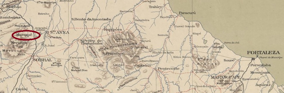
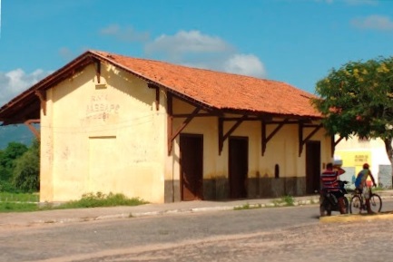
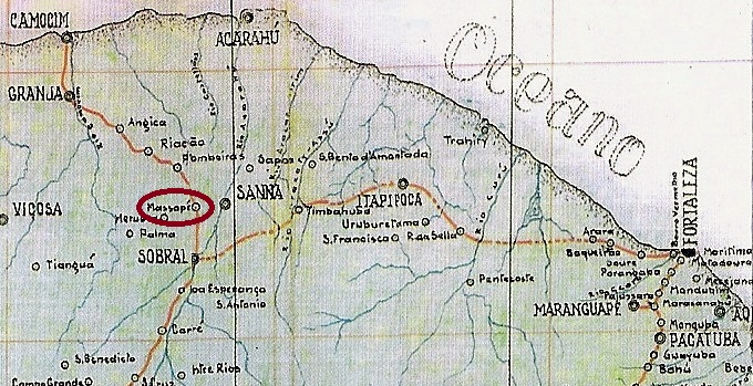
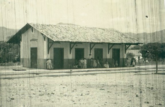
The Massapé railway station (now Massapê) was opened in December 1881 by the E.F. de Sobral railway company (Camocim Branch line). It was located in the municipality of Sant’Anna, in front of the Meruoca Mountains, 250 kilometres west of the provincial capital Fortaleza. The railway line was transferred to Rede de Viação Cearense in 1909 and belonged to Rede Ferroviária Federal S.A. from 1975 until it was decommissioned around 1980 (source: estacoesferroviarias.com.br). The station building has been restored and is now a tourist attraction.
Photo: IBGE, around 1956In February 2019 (photo: Ricardo Melo, on Google Maps)
The area around the station became Freguesia de Serra Verde in February 1882, which was declared a Vila in September 1897. In August 1899, the old place name returned as Município de Massapê. Massapê has been a city since August 1917.
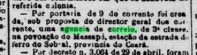
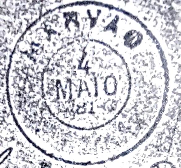
As reported by the regional press, there has been a post office at the railway station since May 1882.
Diario de Pernambuco, 16 May 1882
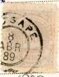
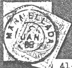
Two imperial postmarks were found. The oldest of these is MCE-0210a (illustration by R. Koester in Carimbologia XXVII):
MCE-0210a (RK) 1882ff-1885
Later, MCE-0210b (illustration from the Internet) was added:
MCE-0210b (EB) 1886-1889Rede de Viação do Ceará, 1924
Andere Schreibweise: Massapê
Der Bahnhof Massapé (heute Massapê) wurde im Dezember 1881 durch die Eisenbahngesellschaft E.F. de Sobral (Camocim-Abzweigung) eröffnet. Er lag im Município de Sant’Anna vor dem Meruoca-Gebirge, 250 Kilometer westlich der Provinzhauptstadt Fortaleza. Die Bahnlinie ging 1909 an die Rede de Viação Cearense über und gehörte von 1975 bis zur Stilllegung um 1980 zur Rede Ferroviária Federal S.A. (estacoesferroviarias.com.br). Das Bahnhofsgebäude wurde restauriert und ist heute ein Touristenmagnet.
Foto: IBGE, um 1956Im Februar 2019 (Foto: Ricardo Melo, auf Google Maps)
Das Gebiet um den Bahnhof wurde im Februar 1882 zur Freguesia de Serra Verde, die im September 1897 zur Vila erklärt wurde. Im August 1899 kehrte der alte Ortsname als Município de Massapê zurück. Seit August 1917 ist Massapê eine Stadt.
Wie die regionale Presse bekannt gab, gab es seit Mai 1882 ein Postamt am Bahnhof.
Diario de Pernambuco, 16.05.1882
Zwei kaiserliche Poststempel sind vorhanden. Der älteste davon ist MCE-0210a (Abb. R. Koester in Carimbologia XXVII):
MCE-0210a (RK) 1882ff-1885
Später kam auch MCE-0210b (Abb. aus dem Internet) dazu:
Villiers de l’Ile Adam: Carta (…) das Provincias de Grão-Pará e Alto Amazonas, 1850
Other names: Nova Mazagão, Marzagão, Regeneração, Mazagão Velho (1915)
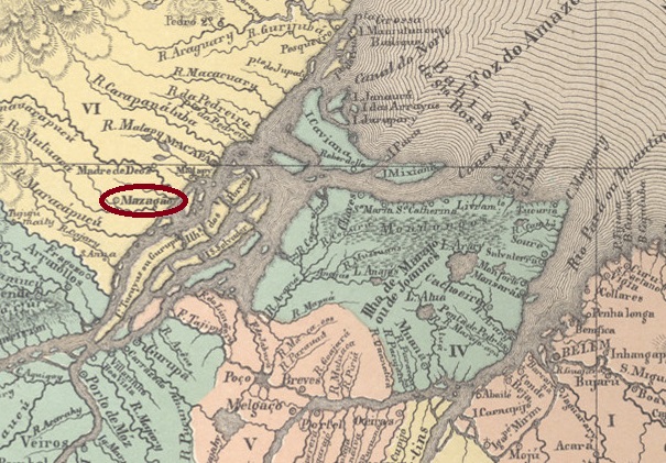
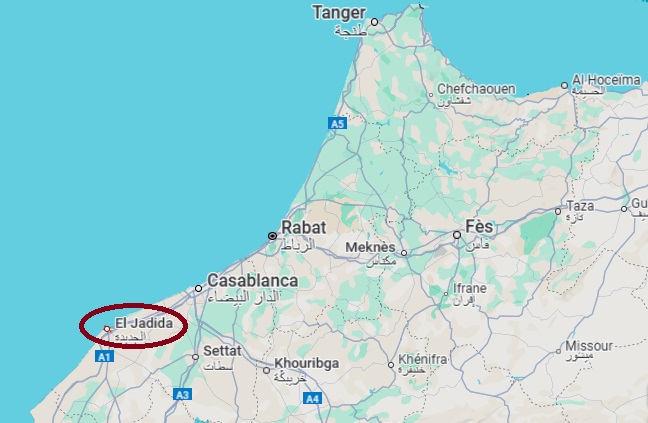
The history of this rather inconspicuous town in northern Brazil now spans four continents and three centuries. It began in 1770 with the founding of Vila de Nossa Senhora da Conceição de Nova Mazagão at the mouth of the Mutucá River (now Mazagão), just under 600 navigated kilometres northwest of the provincial capital Belém do Pará. This vila was intended to provide a new home for Portuguese immigrants from the original Mazagão in the Mauritania region on the north-western coast of Africa. The African Mazagão is now the Moroccan city of El Jadida.
El Jadida, formerly Mazagão (Google Maps)
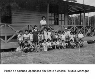
The young village developed into a melting pot of Portuguese, Indians, Jews, Arabs and black slaves on the edge of the Amazon delta. Economic development did not keep pace: Mazagão was downgraded to Freguesia de Regeneração in 1833 and subordinated to the Município de Macapá. In April 1841, it became a vila again and in April 1888 a town. In October 1915, it was downgraded once more, this time to a district called Mazagão Velho in the municipality of Mazaganópolis (formerly Vila Nova do Anauerapucu). As such, the locality was subordinated to Macapá again in November 1930, then back to Mazaganópolis as Mazagão Velho in March 1933, which from then on became the new Municipality of Mazagão. In September 1943, Amapá separated from the state of Pará and became a federal territory. In 1988, it finally became a federal state. From around 1950, Japanese immigrants also began to arrive there.
Around 1953 (IBGE)
It is not known exactly when the local post office was opened. However, since there was already a regular shipping connection to the capital Belém do Pará in 1875, the conditions for postal traffic were met at that time.
Jornal do Pará, 19 August 1875
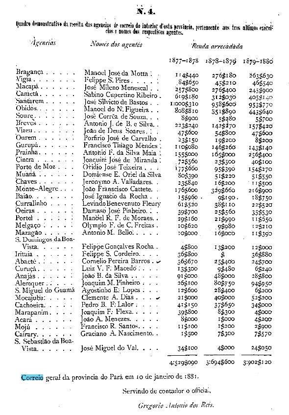
The Mazagão post office was certainly in operation in 1877, as can be seen from the provincial president’s report of February 1881.
Relatorio do Presidente da Provincia, 02/1881
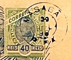
The only postmark from the 19th century to date is MPA-0155b (Fig. Felipe Piccinini):
MPA-0155b (FP) 1896Atlas do Imperio do Brasil, 1868
Andere Namen: Nova Mazagão, Marzagão, Regeneração, Mazagão Velho (1915)
Die Geschichte dieser eher unscheinbaren Ortschaft im Norden Brasiliens umfasst inzwischen vier Kontinente und drei Jahrhunderte. Sie begann im Jahr 1770 mit der Gründung der Vila de Nossa Senhora da Conceição de Nova Mazagão an der Mündung des Flusses Mutucá (heute Mazagão), knapp 600 schiffbare Kilometer nordwestlich der Provinzhauptstadt Belém do Pará entfernt. Diese Vila sollte den portugiesischen Einwanderern aus dem ursprünglichen Mazagão im Gebiet Mauretanien an der Nordwestküste Afrikas eine neue Heimat bieten. Das afrikanische Mazagão ist heute die marokkanische Stadt El Jadida.
El Jadida, ehemals Mazagão (Google Maps)
Die junge Vila entwickelte sich zu einem Schmelztiegel von Portugiesen, Indianern, Juden, Arabern und schwarzen Sklaven am Rande des Amazonasdeltas. Die wirtschaftliche Entwicklung hielt da nicht mit: Mazagão wurde 1833 als Freguesia de Regeneração herabgestuft und dem Município de Macapá untergeordnet. Im April 1841 wurde sie erneut zur Vila und im April 1888 zur Stadt. Im Oktober 1915 wurde sie dann erneut herabgestuft, diesmal zu einem Distrikt namens Mazagão Velho im Municipio Mazaganópolis (ehemals Vila Nova do Anauerapucu). Als solcher wechselte der Ort im November 1930 abermals zu Macapá, dann im März 1933 als Mazagão Velho zurück zu Mazaganópolis, der von nun an der neue Município de Mazagão wurde. Im September 1943 löste sich Amapá vom Bundesstaat Pará und wurde zu einem Bundesgebiet. 1988 wurde es schließlich zu einem Bundesstaat. Ab ca. 1950 kamen auch japanische Einwanderer dorthin.
Ca. 1953 (IBGE)
Wann genau das örtliche Postamt eröffnet wurde, ist nicht bekannt. Da jedoch bereits 1875 eine reguläre Schiffsverbindung zur Hauptstadt Belém do Pará bestand, waren zu diesem Zeitpunkt die Voraussetzungen für den Postverkehr erfüllt.
Jornal do Pará, 19.08.1875
Sicherlich war das Postamt Mazagão im Jahr 1877 in Betrieb, wie aus dem Bericht des Provinzpräsidenten vom Februar 1881 hervorgeht.
Relatorio do Presidente da Provincia, 02/1881
Der bisher einzige Poststempel im 19. Jahrhundert ist MPA-0155b (Abb. Felipe Piccinini):
Other names: Rancho dos Patos, Castello, Castelo do Piauí (1948)
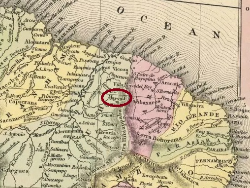
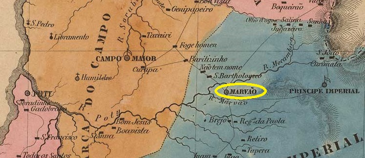
This settlement originally belonged to the Freguesia de Sto. Antonio do Surubim (today’s city of Campo Maior) and was located on the west bank of the Rio Cais, 190 kilometres east of the later capital Teresina. In November 1742, it was named Freguesia de Nossa Senhora do Desterro de Marvão, which became a vila in June 1761. This was followed by three changes to the place name: in March 1890 it was changed to Vila do Castello, in December 1943 back to Marvão and finally in October 1948 to Castelo do Piauí. The original village of Marvão is a small town in the Portuguese Alentejo region with a current population of 3,000.
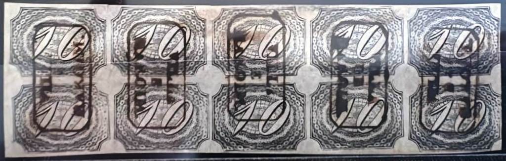
R. Koester writes in Carimbologia XXVII that there had been a post office there since 1824, while the directory of imperial post offices (Tabella das Agencias do Correio do Imperio, Rio de Janeiro, 1885) lists the year 1878. However, the regional press reports on the appointment of an agent in that year. Further press reports about a post office in Marvão were found in 1839, 1854, 1856 and 1864.
Only a faint image of the oldest postmark MPI-0180a (RK) exists in R. Koester (op. cit.).
MPI-0180a (RK) 1861
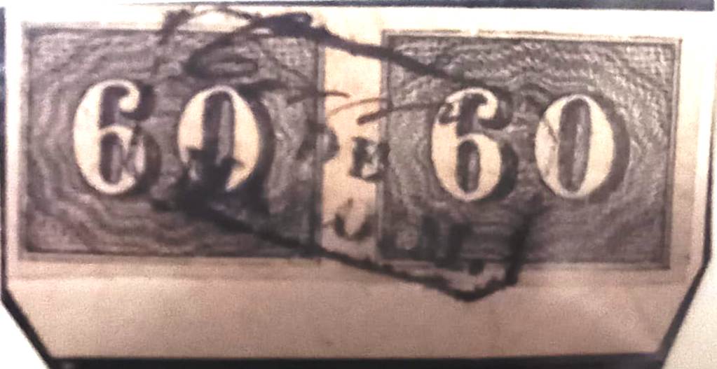
MPI-0180b (Fig. Jorge L. Pedreira) also appeared in the 1880s:
MPI-0180b (JLP) 1881Villiers de l’Ile Adam: Carta (…) da Provincia do Piauhy, 1850
Andere Namen: Rancho dos Patos, Castello, Castelo do Piauí (1948)
Diese Siedlung gehörte ursprünglich zur Freguesia de Sto. Antonio do Surubim (die heutige Stadt Campo Maior) und lag am Westufer des Rio Cais, 190 Kilometer östlich der späteren Hauptstadt Teresina. Im November 1742 erfolgte die Ernennung zur Freguesia de Nossa Senhora do Desterro de Marvão, die im Juni 1761 zur Vila wurde. Es folgten drei Änderungen des Ortsnamens: Im März 1890 wurde er zu Vila do Castello geändert, im Dezember 1943 zurück zu Marvão und schließlich im Oktober 1948 zu Castelo do Piauí. Die ursprüngliche Ortschaft Marvão ist ein Städtchen im portugiesischen Alentejo mit heute 3.000 Einwohnern.
R. Koester schreibt in Carimbologia XXVII, dass es dort seit 1824 ein Postamt gab, während im Verzeichnis der kaiserlichen Postämter (Tabella das Agencias do Correio do Imperio, Rio de Janeiro, 1885) das Jahr 1878 verzeichnet ist. Die regionale Presse berichtet jedoch in diesem Jahr über die Nominierung eines Agenten. Weitere Pressemeldungen über ein Postamt in Marvão fanden sich in den Jahren 1839, 1854, 1856 und 1864.
Vom ältesten Poststempel MPI-0180a (RK) existiert lediglich eine schwache Abbildung in R. Koester (op. cit.).
MPI-0180a (RK) 1861
In den 1880er Jahren kam auch MPI-0180b (Abb. Jorge L. Pedreira):
Villiers de l’Ile Adam: Carta (…) das Provincias de Pernambuco, Alagoas e Sergipe, 1848
Text updated on August 1st, 2025
Maruí or Maruim is the name of the midge (for example: Culicoides sonorensis) in Tupi. It is a small, blood-sucking member of the Ceratopogonidae family, feared throughout Brazil for its bite, which causes severe itching.
Culicoides sonorensis (Wikipedia)
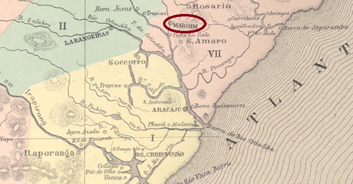
Since February 1835, the Vila de Santo Antonio do Maroim had existed on the eastern bank of the Ganhamoroba, 30 kilometres north of what would later become the provincial capital of Aracaju. The settlement grew out of a large estate with sugar cane plantations and processing facilities, the Engenho de Maruim de Baixo. In January 1837, the Freguesia de Senhor Bom Jesus dos Passos de Maruim was also established, which has had city status since May 1854.
Nova Monteiro writes in Administrações e Agencias Postaes do Brasil Imperio (Brasil Filatelico/RJ, 1934–1935; reprinted by SPP 1994–1999) that there has been a post office there since December 1844. However, the directory of imperial post offices (Tabella das Agencias do Correio do Imperio, Rio de Janeiro, 1885) mentions the year 1848, which is more likely to correspond to an agent nomination, as the agency was still mentioned in the regional press in December 1847.
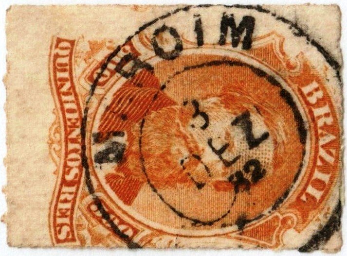
The oldest postmark to date is the attractive MSE-0115a, shown here in a beautiful example (illustration by Marcio Duarte):
MSE-0115a (MDu) 1844 ff
After the town was elevated to city status, the agent sought to have the word VILLA removed from the cancel, as shown in the illustration (Collection Fuad Ferreira Fo.):
1854ff (FF)
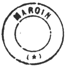
This was followed by the French type MSE-0115b, shown here in an illustration from Cicero A. Almeida’s Carimbos Postais – Século XIX (Rio de Janeiro, 1989). Note the spelling ‘MAROIN’:
MSE-0115b (MPT 394)
This was followed by the double circle MSE-0115c (illustration from the Internet):
MSE-0115c (EB) 1879-1904Atlas do Imperio do Brasil, 1868
Textaktualisierung am 1. August 2025
Maruí oder Maruim ist der Name der Bartmücke (Culicoides sonorensis) auf Tupi. Es handelt sich um einen kleinen, blutsaugenden Vertreter der Familie Ceratopogonidae, der in ganz Brasilien durch seinen mit starkem Juckreiz einhergehenden Stich gefürchtet wird.
Culicoides sonorensis (Wikipedia)
Seit Februar 1835 bestand die Vila de Santo Antonio do Maroim am Ostufer des Ganhamoroba, 30 Kilometer nördlich der späteren Provinzhauptstadt Aracaju. Die Siedlung entstand aus einem Großgrundbesitz mit Zuckerrohrplantage und -verarbeitung, dem Engenho de Maruim de Baixo. Im Januar 1837 wurde auch die Freguesia de Senhor Bom Jesus dos Passos de Maruim ins Leben gerufen, die seit Mai 1854 Stadtstatus hat.
Nova Monteiro schreibt in Administrações e Agencias Postaes do Brasil Imperio (Brasil Filatelico/RJ, 1934–1935; Nachdruck SPP 1994–1999), dass es dort seit Dezember 1844 ein Postamt gab. Im Verzeichnis der kaiserlichen Postämter (Tabella das Agencias do Correio do Imperio, Rio de Janeiro, 1885) wird hingegen das Jahr 1848 genannt, was jedoch eher einer Agentennominierung entsprechen dürfte, da die Agentur noch im Dezember 1847 in der regionalen Presse erwähnt wurde.
Der bisher älteste Poststempel ist der ansprechende MSE-0115a, hier in einem wunderschönen Beispiel (Abb. Marcio Duarte):
MSE-0115a (MDu) 1844 ff
Nach der Erhebung zur Stadt bemühte sich der Agent um das Verschwinden des Wortes VILLA aus dem Stempel, wie die Abbildung (Samml. Fuad Ferreira Fo.) zeigt:
1854ff (FF)
Es folgte der französische Typ MSE-0115b, hier in einer Abbildung aus Cicero A. Almeidas Carimbos Postais – Século XIX (Rio de Janeiro, 1989). Man beachte die Schreibweise „MAROIN”:
MSE-0115b (MPT 394)
Danach kam der Doppelkreis MSE-0115c (Abb. aus dem Internet):
See also Abaeté (AMG-0005) and Dores da Marmellada (DMG-1025)
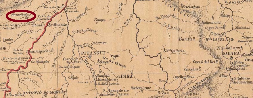
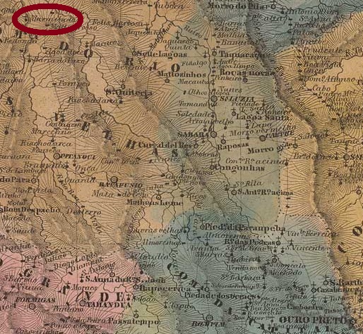
In the Tupi-guarani language, Abaeté means strong and brave man. This was also Indian tribe name that originally inhabited this area on the north bank of the Marmelada River, 300 km northwest of the provincial capital Ouro Preto. In July 1864, the settlement became the Freguesia of Nossa Senhora do Patrocínio da Marmellada, in the Município of Dores do Indayá. When in September 1870 Dores do Indayá was downgraded to a district of Pitangui, Patrocínio da Marmellada was given the status of a villa, and since November 1877 it has been the town of Abaeté.
As Paula Sobrinho writes in História Postal de MInas Gerais (Belo Horizonte, 1997), there was a post office there since June 1873, a year confirmed by the Directory of Imperial Post Offices (Tabella das Agencias do Correio do Imperio, Rio de Janeiro, 1885). So far no postmark with DORES DA MARMELLADA has been seen, but Koester (Carimbologia XVI and XXVII) shows the MARMELLADA postmark MMG-3390a:
MMG-3390a (RK) 1884-1886
From about 1887 local postmarks show ABAETÉ (see AMG-0005).
Villiers de l’Ile Adam: Carta (…) da Provincia de Minas Geraes, 1849
Andere Namen: Patrocínio da Marmellada, Abaeté
Siehe auch Abaeté (AMG-0005) und Dores da Marmellada (DMG-1025)
In der Tupi-guarani-Sprache bedeutet Abaeté starker und tapferer Mann. So hieß auch der Indianerstamm, der ursprünglich diese Gegend am Nordufer des Flusses Marmelada bewohnte, 300 km nordwestlich der Provinzhauptstadt Ouro Preto entfernt. Im Juli 1864 wurde aus der Siedlung die Freguesia von Nossa Senhora do Patrocínio da Marmellada, im Município von Dores do Indayá. Als im September 1870 Dores do Indayá zu einem Distrikt von Pitangui herabgesetzt wurde, bekam Patrocínio da Marmellada den Status einer Villa, die seit November 1877 die Stadt Abaeté heißt.
Wie Paula Sobrinho in História Postal de Minas Gerais (Belo Horizonte, 1997) schreibt, gab es dort ein Postamt seit Juni 1873. Das Jahr wird durch das Verzeichnis der kaiserlichen Postämter (Tabella das Agencias do Correio do Imperio, Rio de Janeiro, 1885) bestätigt. Bisher wurde kein Poststempel mit DORES DA MARMELLADA gesehen, aber Koester (Carimbologia XVI und XXVII) zeigt den MARMELLADA-Stempel MMG-3390a:
MMG-3390a (RK) 1884-1886
Um 1887 kam der Poststempel mit ABAETÉ (s. AMG-0005).
Villiers de l’Ile Adam: Carta (…) da Provincia do Rio de Janeiro, 1850
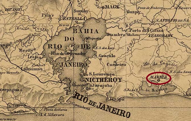
The Freguesia de Santa Maria de Maricá existed since January 1755 and was located on the northern shore of Lake Maricá, 60 kilometres east of the colonial capital Rio de Janeiro. In May 1814, it was elevated to the status of a vila and in December 1889, it finally became the city of Nossa Senhora do Amparo de Maricá.
As Nova Monteiro writes in Administrações e Agencias Postaes do Brasil Imperio (Brasil Filatelico/RJ, 1934–1935; reprinted by SPP 1994–1999), there had been a post office there since June 1829.
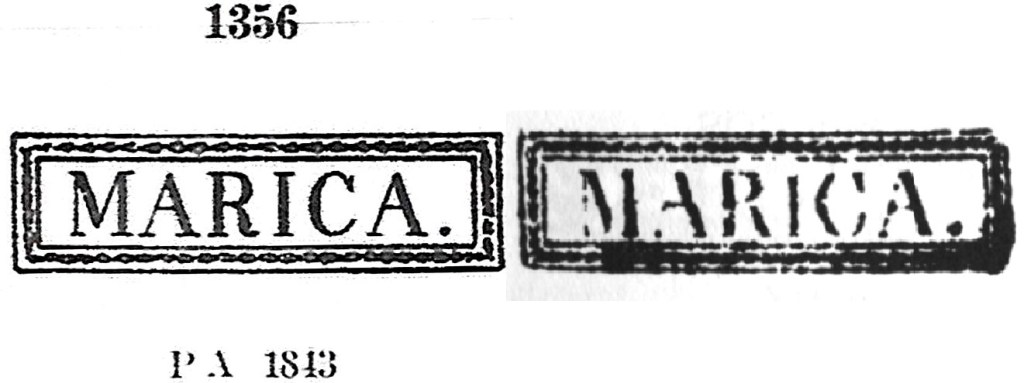
The oldest postmark to date is MRJ-0720a, which also appears in brown, red and green. It was registered by P. Ayres under number 1356 in Catálogo de Carimbos Brasil-Império (São Paulo, 1937, 1942) and by Cicero A. Almeida under MPT 381 in Carimbos Postais – Século XIX (Rio de Janeiro, 1989).
MRJ-0720a (MPT 381, P.A. 1356) 1843ff-1883ff
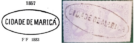
This was followed by MRJ-0720b, also recorded by P. Ayres (op. cit.), here also in an illustration by José A. Junges:
MRJ-0720b (P.A. 1357 – JJ) 1877ff-1883ff
Shortly afterwards, the double circle MRJ-0720c (illustration from the Internet) also appeared:
MRJ-0720c (EB) 1879-1895, also in blueLaemmert: Provincia do Rio de Janeiro, 1866
Die Freguesia de Santa Maria de Maricá bestand seit Januar 1755 und lag am Nordufer des Maricá-Sees, 60 Kilometer östlich der Kolonialhauptstadt Rio de Janeiro. Im Mai 1814 wurde sie zur Vila und im Dezember 1889 schließlich zur Stadt Nossa Senhora do Amparo de Maricá erhoben.
Wie Nova Monteiro in Administrações e Agencias Postaes do Brasil Imperio (Brasil Filatelico/RJ, 1934–1935; Nachdruck SPP 1994–1999) schreibt, gab es dort seit Juni 1829 ein Postamt.
Der bisher älteste Poststempel ist MRJ-0720a, der auch in den Farben Braun, Rot und Grün vorkommt. Er wurde sowohl von P. Ayres unter der Nummer 1356 im Catálogo de Carimbos Brasil-Império (São Paulo, 1937, 1942) als auch von Cicero A. Almeida unter MPT 381 in Carimbos Postais – Século XIX (Rio de Janeiro, 1989) registriert wurde.
MRJ-0720a (MPT 381, P.A. 1356) 1843ff-1883ff
Es folgte MRJ-0720b, ebenfalls durch P. Ayres (op. cit.) erfasst, hier auch in einer Abbildung von José A. Junges:
MRJ-0720b (P.A. 1357 – JJ) 1877ff-1883ff
Kurze Zeit später kam auch der Doppelkreis MRJ-0720c (Abb. aus dem Internet):
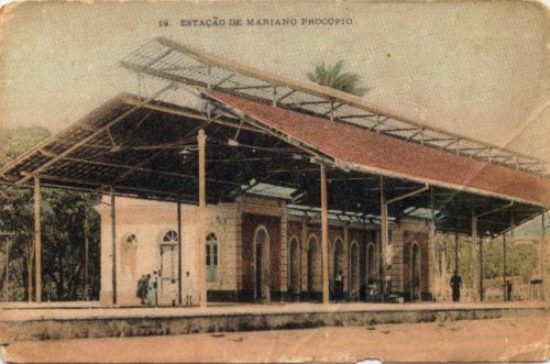
See also Rio Novo (train station, RMG-3583) and Fortaleza de Sant’Anna (FMG-1197)
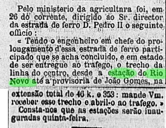
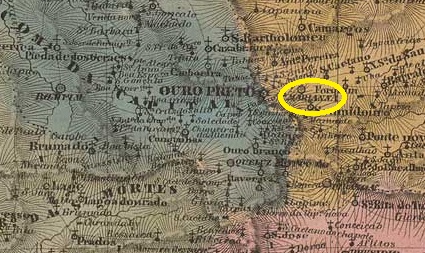
This station post office in imperial Minas Gerais was originally called Rio Novo, a station on the Estrada de Ferro D. Pedro II railway line, known as the Linha do Centro (Central Line), located just a few kilometres north of Juiz de Fora. Ralph Giesbrecht (estacoesferroviarias.com.br) writes that the station was inaugurated in November 1876. However, this date probably needs to be corrected to February 1877, as can be seen from the press in Rio de Janeiro.
Gazeta de Noticias/RJ, 29 January 1877
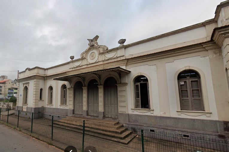
The D. Pedro II Railway Company had to change its name in November 1889 and was henceforth called Estrada de Ferro Central do Brasil. From 1975 until the end of operations in 1996, the company became Rede Ferroviária Federal S.A. In 2017, the station building still housed a cultural centre, but today it appears abandoned.
Around 1940 (Image by Monachesi/Ferreira, on estacoesferroviarias.com.br)In April 2024 (Google Street View)
When the railway company Cia. União Mineira opened another station called Rio Novo in the municipality of the same name (RMG-2145) in 1883, the former Rio Novo station post office in Mariano Procopio was renamed. The station itself was not renamed until around 1915.
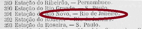
Paula Sobrinho cites July 1881 as the year the station post office was created in História Postal de Minas Gerais (Belo Horizonte, 1977). However, as it was already listed in the imperial postal guide (Guia Postal do Império) from 1880 under number 391, this agency must have been established between 1877 and 1879. Since both the railway and postal administrations were operated from Rio de Janeiro until Juiz de Fora at that time, it was not assigned to the province of Minas Gerais here.
Guia Postal do Império, 1880
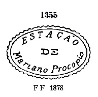
The oldest postmark under Mariano Procopio is MMG-1570a, which was given the number 1355 by P. Ayres in Catálogo de Carimbos Brasil-Império (São Paulo, 1937, 1942):
MMG-1570a (P.A. 1355) 1885ff
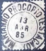
Shortly afterwards, MMG-1570b (Fuad Ferreira Fo. collection) also appeared, which also exists in green:
MMG-1570b (FF) 1885-1892
For postmarks with Rio Novo (train station) see RMG-3583.
Estações (…) de São Paulo, Rio de Janeiro e Minas Geraes, 1880
Siehe auch Rio Novo (Bahnhof, RMG-3583) und Fortaleza de Sant’Anna (FMG-1197)
Dieses Postamt im kaiserlichen Minas Gerais hieß ursprünglich Rio Novo, an einem Bahnhof der Estrada de Ferro D. Pedro II in der sogenannten Linha do Centro (Hauptlinie) und lag nur wenige Kilometer nördlich von Juiz de Fora. Ralph Giesbrecht (estacoesferroviarias.com.br) schreibt, dass der Bahnhof im November 1876 eingeweiht wurde. Wahrscheinlich muss dieses Datum jedoch auf Februar 1877 korrigiert werden, wie aus der Presse in Rio de Janeiro zu entnehmen ist.
Gazeta de Noticias/RJ, 29.01.1877
Die D. Pedro II Eisenbahngesellschaft musste im November 1889 ihren Namen ändern und hieß fortan Estrada de Ferro Central do Brasil. Von 1975 bis zum Betriebsende 1996 ging die Gesellschaft in die Rede Ferroviária Federal S.A. über. Im Jahr 2017 beherbergte das Bahnhofsgebäude noch ein Kulturzentrum, aber heute scheint es verlassen zu sein.
Ca. 1940 (Abb. Monachesi/Ferreira, auf estacoesferroviarias.com.br)Im April 2024 (Google Street View)
Da die Bahngesellschaft Cia. União Mineira 1883 einen anderen Bahnhof Rio Novo im gleichnamigen Município (RMG-2145) eröffnete, wurde das frühere Bahnhofspostamt Rio Novo in Mariano Procopio umbenannt. Der Bahnhof selbst wurde erst um 1915 umbenannt.
Paula Sobrinho nennt in História Postal de Minas Gerais (Belo Horizonte, 1977) den Juli 1881 als Entstehungsjahr des Bahnhofspostamts. Da dieses jedoch bereits im kaiserlichen Postführer (Guia Postal do Império) aus dem Jahr 1880 unter der Nummer 391 aufgeführt wurde, muss diese Agentur zwischen 1877 und 1879 errichtet worden sein. Da sowohl die Bahn- als auch die Postverwaltung bis Juiz de Fora damals von Rio de Janeiro aus betrieben wurde, wurde sie hier nicht der Provinz Minas Gerais zugeordnet.
Guia Postal do Império, 1880
Der älteste Poststempel unter Mariano Procopio ist MMG-1570a, der von P. Ayres die Nr. 1355 in Catálogo de Carimbos Brasil-Império (São Paulo, 1937, 1942) erhielt:
MMG-1570a (P.A. 1355) 1885ff
Kurze Zeit später erschien auch MMG-1570b (Samml. Fuad Ferreira Fo.), der auch in Grün vorkommt:
MMG-1570b (FF) 1885-1892
Für Stempel mit Rio Novo (Bahnhof) siehe RMG-3583.
Villiers de l’Ile Adam: Carta (…) da Provincia de Minas Geraes, 1849
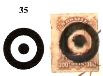
Other names: Albuquerque, Ribeirão do Carmo
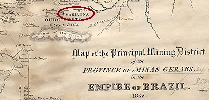
The Vila de Albuquerque existed since April 1711 at Ribeirão do Carmo, 15 kilometres east of the later provincial capital Vila Rica or Ouro Preto. In April 1712, it was renamed Ribeirão do Carmo. In April 1745, it was elevated to Freguesia de N. Sra. da Assumpção da Sé de Marianna and subsequently granted city status.
No fewer than four different dates have been found for the establishment of the local post office: first in March 1798, as Paula Sobrinho writes in História Postal de Minas Gerais (Belo Horizonte, 1997). A second time in March 1829, as stated in Administrações e Agencias Postaes do Brasil Imperio (Brasil Filatelico/RJ, 1934–1935; reprinted by SPP 1994–1999) by Nova Monteiro. The year 1833 is mentioned once more, as can be read in the postal report (Relatorio Postal) for the year 1886, and finally, the year 1846 is listed in the directory of imperial post offices (Tabella das Agencias do Correio do Imperio, Rio de Janeiro, 1885). We can therefore assume that this agency was closed more times.
The oldest postmark to date is MMG-1565a, which has been found in pink, sepia, red, green and yellow. Paulo Ayres gave it the number 1153 in his Catálogo de Carimbos Brasil-Império (S. Paulo, 1937, 1942).
MMG-1565a (P.A. 1153 – RHM P-MG-35), 1825–1850 ff
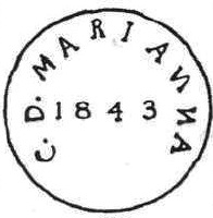
This was followed by the rare MMG-1565b (illustration by R. Koester in Carimbologia XXVII), which also occurs in sepia.
MMG-1565b (RK, RHM P-MG-36), 1841–1843
Next came MMG-1565c, which also exists in red and possibly in two variants, as shown in the illustrations by R. Koester (op. cit.) and Henrique B. Ferreira (Catálogo Ilustrado dos Carimbos Sobre os Olhos-de-Boi, Porto Alegre, 2017).
MMG-1565c (RK, HBF M15) 1843–1846
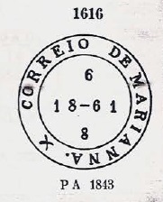
According to P. Ayres (op. cit., No. 1616), the archaic-looking MMG-1565d is also said to appear on Bull’s-eyes stamps, but this has not yet been confirmed.
MMG-1565d (P. A. 1616) 1850 ff–1865
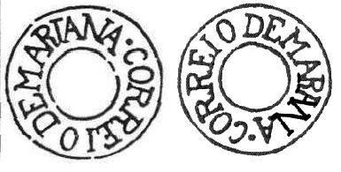
The subsequent double circle MMG-1565g (illustration from the Internet) was used until the end of the 19th century.
MMG-1565g (EB) 1878–1897
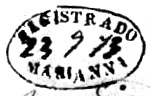
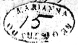
Marianna also used three own registered cancels.
MMG-1565e (ill. Koester) 1870MMG-1565f (ill.Koester) 1873MMG-1565h (ill. Felipe Piccinini) 1881–1883
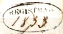
Three mute postmarks, which can be found in Mute Cancellations of the Brazil Empire/Carimbos Mudos do Brasil Império (Brazil Philatelic Association, Rio de Janeiro, 2000) by James Dingler and Klerman W. Lopes, could be attributed to Marianna:
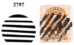
BPA 3937 (P.A. 608) 1866ffBPA 35 (illustration: Felipe Piccinini) 1881BPA 2797 (illustration: Felipe Piccinini) 1883Province of Minas Geraes, 1835
Andere Namen: Albuquerque, Ribeirão do Carmo
Die Vila de Albuquerque bestand seit April 1711 am Ribeirão do Carmo, 15 Kilometer östlich der späteren Provinzhauptstadt Vila Rica bzw. Ouro Preto. Im April 1712 wurde sie zu Ribeirão do Carmo umbenannt. Im April 1745 wurde sie zur Freguesia de N. Sra. da Assumpção da Sé de Marianna erhoben und erhielt anschließend den Status einer Stadt.
Es wurden nicht weniger als vier verschiedene Daten für die Entstehung des örtlichen Postamts gefunden: erstmals im März 1798, wie Paula Sobrinho in História Postal de Minas Gerais (Belo Horizonte, 1997) schreibt. Ein zweites Mal im März 1829, wie aus Administrações e Agencias Postaes do Brasil Imperio (Brasil Filatelico/RJ, 1934–1935; Nachdruck SPP 1994–1999) von Nova Monteiro hervorgeht. Ein weiteres Mal wird das Jahr 1833 genannt, wie im Postbericht (Relatorio Postal) für das Jahr 1886 nachzulesen ist, und schließlich wird das Jahr 1846 im Verzeichnis der kaiserlichen Postämter (Tabella das Agencias do Correio do Imperio, Rio de Janeiro, 1885) aufgeführt. Wir können daher davon ausgehen, dass diese Agentur mehrmals geschlossen wurde.
Der bisher älteste Poststempel ist MMG-1565a, der bisher in den Farben Rosa, Sepia, Rot, Grün und Gelb gefunden wurde. Paulo Ayres gab ihm die Nr. 1153 in seinem Werk Catálogo de Carimbos Brasil-Império (S. Paulo, 1937, 1942).
MMG-1565a (P.A. 1153 – RHM P-MG-35), 1825–1850 ff
Es folgte der seltene MMG-1565b (Abbildung bei R. Koester in Carimbologia XXVII), der ebenfalls in Sepia vorkommt.
MMG-1565b (RK, RHM P-MG-36), 1841–1843
Danach kam MMG-1565c, der auch in Rot existiert und möglicherweise in zwei Varianten vorkommt, wie die Abbildungen von R. Koester (op. cit.) und Henrique B. Ferreira (Catálogo Ilustrado dos Carimbos Sobre os Olhos-de-Boi, Porto Alegre, 2017) zeigen.
MMG-1565c (RK, HBF M15) 1843–1846
Der archaisch anmutende MMG-1565d soll laut P. Ayres (op. cit., Nr. 1616) auch auf Ochsenaugen vorkommen, was bisher jedoch nicht bestätigt werden konnte.
MMG-1565d (P. A. 1616) 1850 ff–1865
Der anschließende Doppelkreis MMG-1565g (Abbildung aus dem Internet) wurde bis gegen Ende des 19. Jahrhunderts verwendet.
MMG-1565g (EB) 1878–1897
Marianna hatte auch drei eigene Einschreibstempel benutzt.
MMG-1565e (Abbildung Koester) 1870MMG-1565f (Abbildung Koester) 1873MMG-1565h (Abbildung von Felipe Piccinini) 1881–1883
Drei stumme Poststempel, die in Mute Cancellations of the Brazil Empire/Carimbos Mudos do Brasil Império (Brazil Philatelic Association, Rio de Janeiro, 2000) von James Dingler und Klerman W. Lopes zu finden sind, konnten Marianna zugeordnet werden:
BPA 3937 (P.A. 608) 1866ffBPA 35 (Abb.: Felipe Piccinini) 1881BPA 2797 (Abb.: Felipe Piccinini) 1883
Villiers de l’Ile Adam: Carta (….) da Provincia do Ceara, 1849
Other names: Boca da Picada, Benjamin Constant, Mombaça (1943)
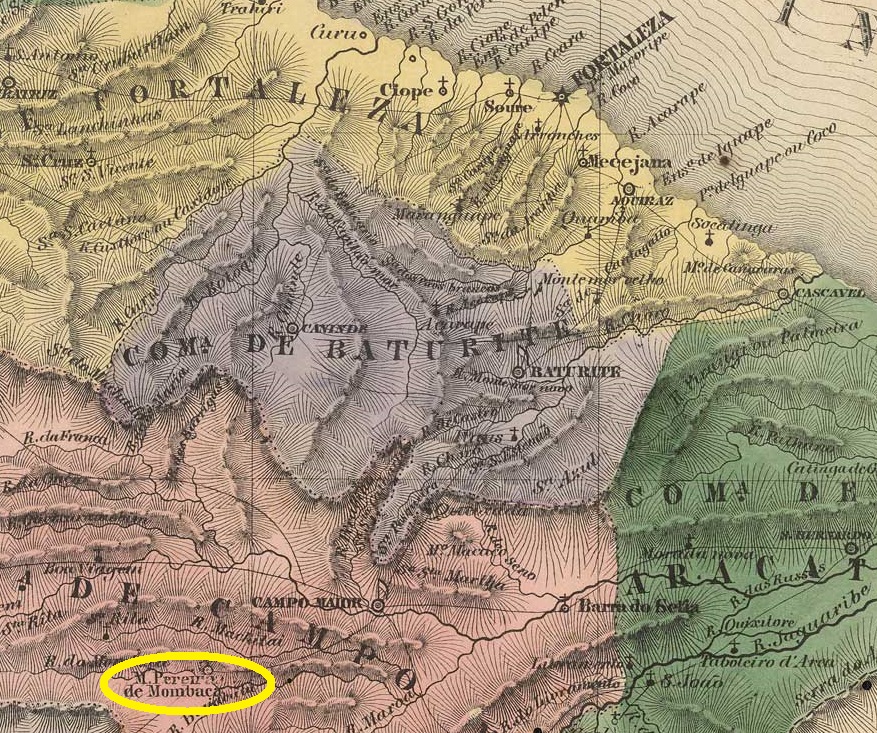
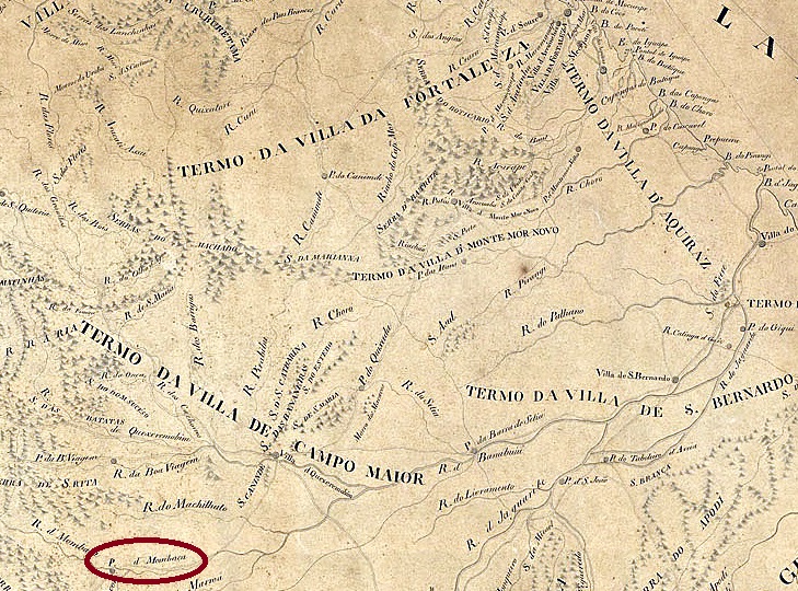
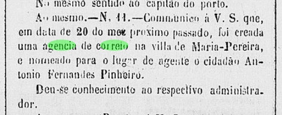
This village, which is old by Brazilian standards, had been the Boca da Picada farm since October 1706, owned by Maria Pereira da Silva, one of the first settlers in the area. The fazenda was located on the south bank of the Banabuiú River, 300 kilometres southwest of the future provincial capital Fortaleza. In September 1832, it was elevated to Freguesia de N. Sra. da Glória de Maria Pereira and belonged to Vila de Quixeramobim. Since its elevation to Vila in November 1851, the place name has changed three times: in 1890 it became Município de Benjamin Constant, in September 1918 it was renamed Maria Pereira (under this name it was elevated to a city in December 1938) and finally, in December 1943, it became the Município de Mombaça.
At least two periods of operation have been found for the local post office. Unfortunately, it is not known when the first one began. However, it ended in 1851, as can be seen from the report of the Imperial Ministry.
Relatorio do Ministerio do Imperio, 1851
R. Koester writes in Carimbologia XXVII that the post office was reopened in September 1867. However, Nova Monteiro in Administrações e Agencias Postaes do Brasil Imperio (Brasil Filatelico/RJ, 1934–1935; reprinted SPP 1994–1999) gives a date three months later. This is confirmed by the regional press:
Jornal do Ceara, 20 February 1868
The only imperial postmark to date is MCE-0205b (Klerman Lopes collection):
MCE-0205b (KL) 1883ffCarta da Capitania do Ceara, 1818
Andere Namen: Boca da Picada, Benjamin Constant, Mombaça (1943)
Diese für brasilianische Verhältnisse alte Ortschaft war seit Oktober 1706 die Fazenda Boca da Picada, die Maria Pereira da Silva, einer der ersten Siedler des Ortes, gehörte. Die Fazenda lag am Südufer des Flusses Banabuiú, 300 Kilometer südwestlich der späteren Provinzhauptstadt Fortaleza. Im September 1832 wurde sie zur Freguesia de N. Sra. da Glória de Maria Pereira erhoben und gehörte zur Vila de Quixeramobim. Seit dem Aufstieg zur Vila im November 1851 wechselte der Ortsname dreimal: 1890 wurde er zu Município de Benjamin Constant, im September 1918 erfolgte die Rückbenennung zu Maria Pereira (unter diesem Namen wurde zu einer Stadt im Dezember 1938 erhoben) und schließlich wurde sie im Dezember 1943 zu Município de Mombaça.
Es wurden mindestens zwei Betriebsperioden fürs örtliche Postamt gefunden. Leider ist nicht bekannt, wann die erste begann. Sie endete jedoch im Jahr 1851, wie aus dem Bericht des Imperialministeriums hervorgeht.
Relatorio do Ministerio do Imperio, 1851
R. Koester schreibt in Carimbologia XXVII, dass das Postamt im September 1867 wiedereröffnet wurde. Allerdings nennt Nova Monteiro in Administrações e Agencias Postaes do Brasil Imperio (Brasil Filatelico/RJ, 1934–1935; Nachdruck SPP 1994–1999) ein Datum, das drei Monate später liegt. Dieses wird durch die regionale Presse bestätigt:
Jornal do Ceara, 20.02.1868
Der bisher einzige kaiserliche Poststempel ist MCE-0205b (Samml. Klerman Lopes):
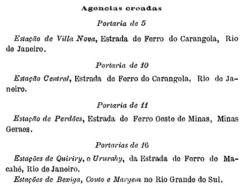
Other names: Margem do Taquary, Ligação, General Câmara (1939)
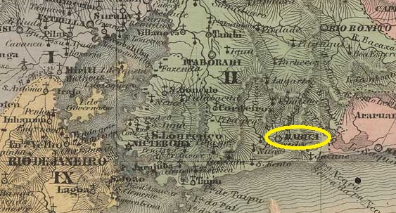
It has not yet been possible to determine exactly when the railway company E.F. Porto Alegre a Uruguayana first opened Margem (Shore) station. The oldest press mention to date is from February 1884.
A Federação, 28 February 1884
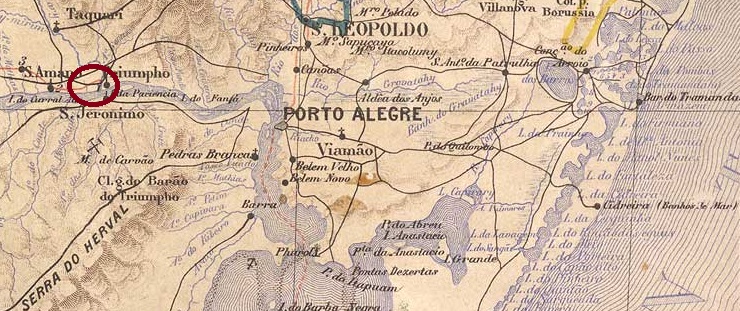
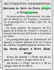
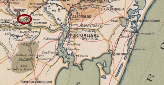
As can be seen on the top map, the station was located on the west bank of the Taquari mouth in the Jacuí in the municipality of Santo Amaro, 70 kilometres west of the provincial capital Porto Alegre. The railway line was transferred to the Cie. Auxiliaire des Chemins de Fer au Brésil in 1911. In the same year, it was connected to the existing railway line of the E.F. de Porto Alegre a Novo Hamburgo. For this purpose, a new station called Ligação (Connection) was built five kilometres further north (image below). In March 1920, the railway line was transferred to Viação Férrea do Rio Grande do Sul and belonged to Rede Ferroviária Federal S. A. from 1975 until its closure in 1996 (estacoesferroviarias.com.br). There is no information available about the original station and its tracks.
The area around the station became the district of Margem do Taquary around 1900 and the municipality of Margem in March 1938. Since June 1939, this municipality has been called General Câmara.
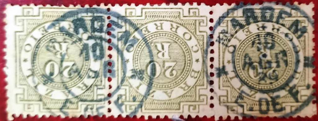
Another mystery is the date of creation of the station post office. According to the Post Bulletin (Boletim Postal) of October 1889, the post office was created in September 1889.
Boletim Postal No. 6, 10/1889
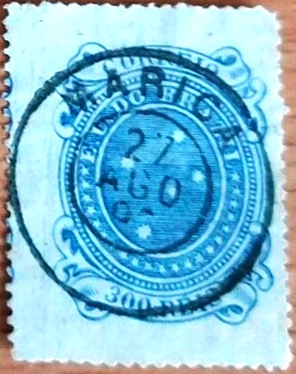
However, earlier postmark dates are known, as shown by the example of MRS-0560a (Fig. José L. Fevereiro):
MRS-0560a (JLF) 1889-1890ffEstado do Rio Grande do Sul, 1924
Andere Namen: Margem do Taquary, Ligação, General Câmara
Bisher konnte nicht ermittelt werden, wann genau die Eisenbahngesellschaft E.F. Porto Alegre a Uruguayana den Bahnhof Margem (Ufer) erstmals eröffnete. Die bisher älteste Presseerwähnung datiert vom Februar 1884.
A Federação, 28.02.1884
Wie der obersten Karte zu entnehmen ist, lag der Bahnhof am Westufer der Mündung des Taquari in den Jacuí im Município de Santo Amaro, 70 Kilometer westlich der Provinzhauptstadt Porto Alegre. Die Bahnlinie ging 1911 an die Cie. Auxiliaire des Chemins de Fer au Brésil über. Im gleichen Jahr wurde sie mit der bereits bestehenden Bahnlinie der E.F. de Porto Alegre a Novo Hamburgo verbunden. Dafür wurde fünf Kilometer weiter nördlich ein neuer Bahnhof namens Ligação (Verbindung) gebaut (zweite Abbildung oben). Im März 1920 ging die Bahnlinie an die Viação Férrea do Rio Grande do Sul über und gehörte von 1975 bis zur Stilllegung im Jahr 1996 zur Rede Ferroviária Federal S. A. (estacoesferroviarias.com.br). Über den ursprünglichen Bahnhof und die Gleise fehlen jegliche Informationen.
Das Gebiet um den Bahnhof wurde um 1900 zum Distrikt Margem do Taquary und im März 1938 zur Gemeinde Margem. Seit Juni 1939 heißt dieser Município General Câmara.
Ein weiteres Rätsel stellt das Entstehungsdatum des Bahnhofspostamts dar. Wie dem Postbulletin (Boletim Postal) vom Oktober 1889 zu entnehmen ist, existierte das Postamt seit September 1889.
Boletim Postal Nr. 6, 10/1889
Es sind jedoch frühere Stempeldaten bekannt, wie das Beispiel für MRS-0560a (Abb. José L. Fevereiro) zeigt: