Categories
Carimbologia H-L

Juiz de Fora, Minas Gerais (JMG-1445)

Altas do Imperio do Brasil, 1868

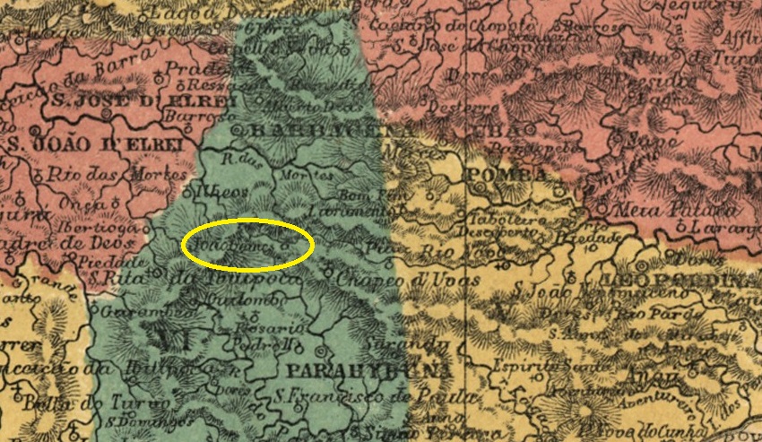
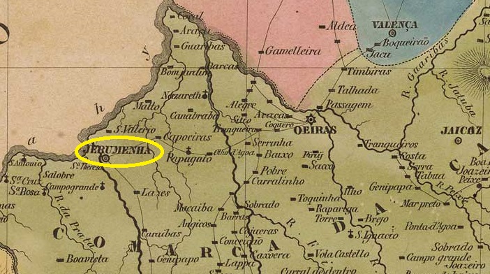
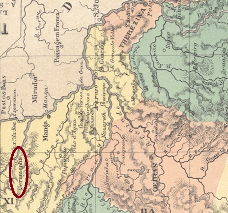
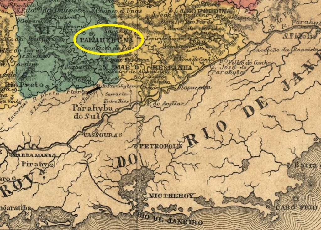
Other names: Santo Antonio do Parahybuna, Parahybuna

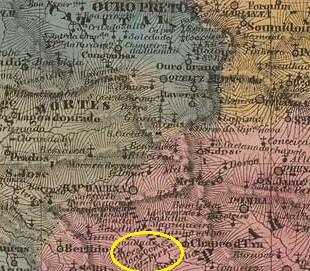
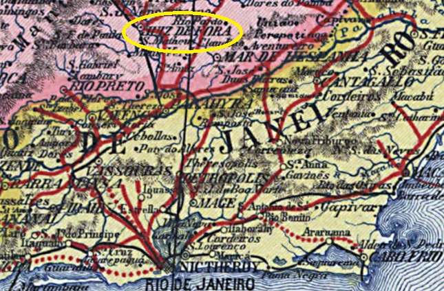
Since March 1781, a Fazenda do Juiz de Fora existed on the west bank of the Paraibuna around Vila de S. João d’El Rei, 230 kilometres south of the later provincial capital of Ouro Preto. In March 1844, the chapel of Sto. Antonio do Parahybuna was consecrated here, which was assigned to the Vila de Santo Antonio do Parahybuna in May 1850. Parahybuna was elevated to the status of town in May 1856 and in December 1865 the original name was changed back as Município de Juiz de Fora.

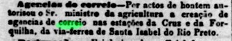
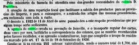
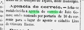
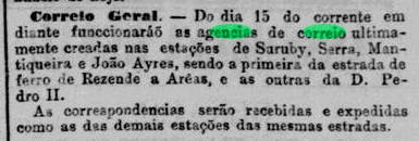
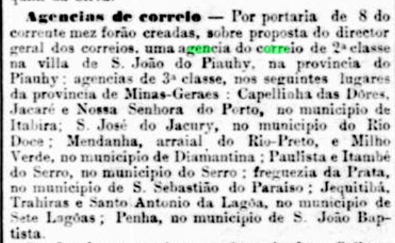
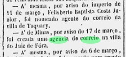
In March 1851, it was decided to establish a local post office, as reported in the Rio de Janeiro press:

Diario do Rio de Janeiro, 15/04/1851

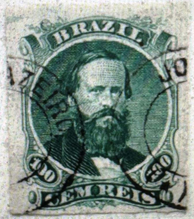
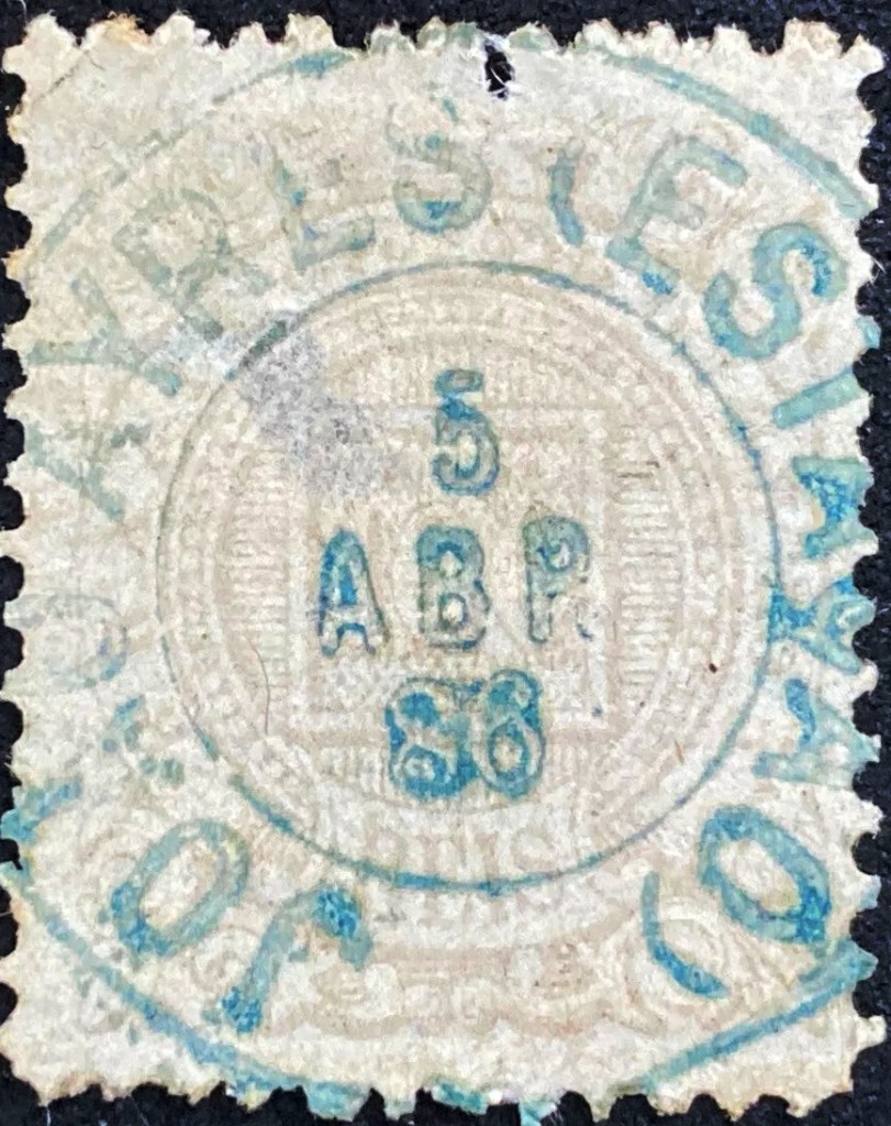
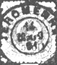
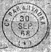
The first postmarks still bear the place name Parahybuna. The oldest to date is PMG-3925b (fig. R. Koester, in Carimbologia XXV):

PMG-3925b (RK) 1863

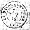
Two French type postmarks followed. The first is PMG-3925c (fig. Koester, op. cit.):

PMG-3925c (RK) 1868

The second, slightly modified, is PMG-3925d (fig. Koester):

PMG-3925d (RK) 1871-1882

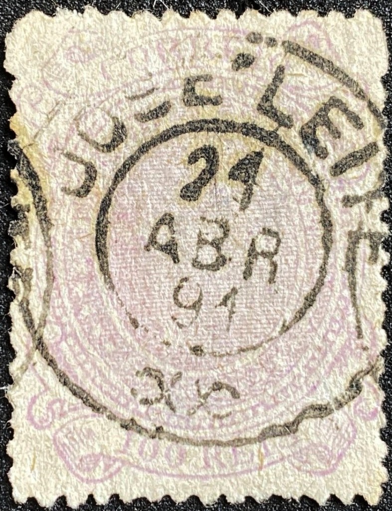
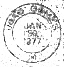
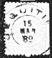
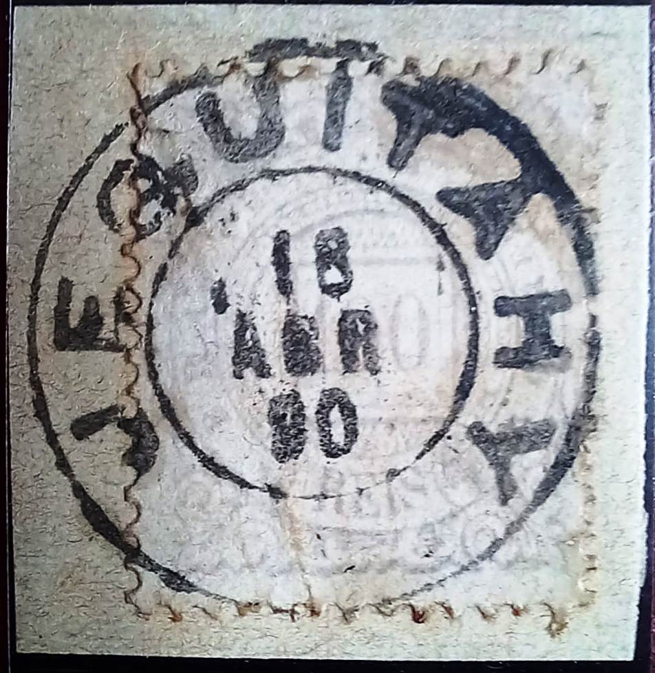
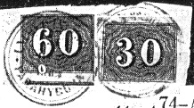
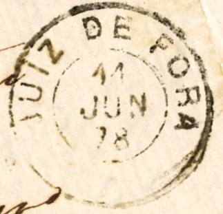
From around 1877, the place name Juiz de Fora appears on the postmarks, beginning with JMG-1445a (collect. FM):

JMG-1445a (FM) 1877-1878

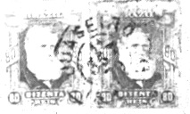
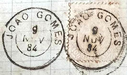
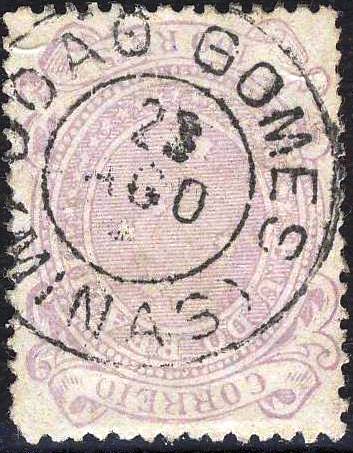
Then came the interesting JMG-1445b, which is illustrated in P. Ayres’ Catálogo de Carimbos Brasil-Império (S. Paulo, 1937, 1942) on page 122. However, the illustration was corrected by Koester:

JMG-1445b (P.A. p.122, recte RK) 1884-1888

At the end of the Empire, two more circle cancels appeared, first JMG-1445c (fig. Koester):

JMG-1445c (RK) 1887-1889

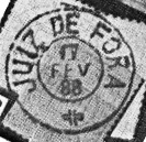
Shortly afterwards, JMG-1445d (fig. Koester) appeared:

JMG-1445d (RK) 1889-1892

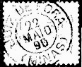
The following postmark JMG-1445e (illustration from the Internet) is probably already republican:

JMG-1445e (EB) 1891

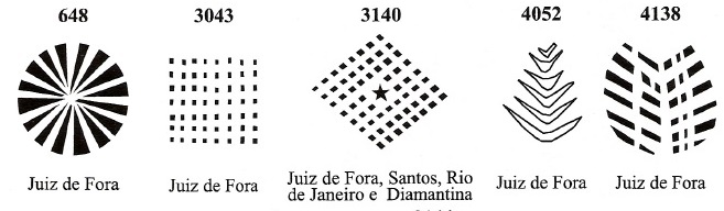
James Dingler and Klerman W. Lopes have listed five mute cancels from Juiz de Fora in Mute Cancellations of the Brazil Empire / Carimbos Mudos do Brasil Império (Brazil Philatelic Association, Rio de Janeiro, 2000):

BPA 648 (1866ff-1882ff) – 3043 – 3140 – 4052 – 4138 (1868)

Two further mute cancellations are known:

1867 (Coll. Jacques Benchimol)
1878 (coll. FM)

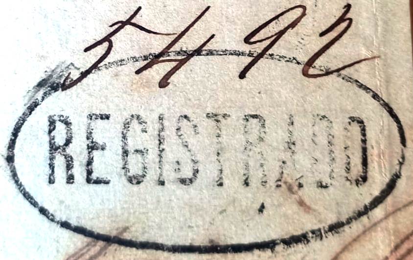
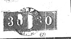
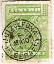
The philatelist Fuad Ferreira Fo. also showed a registered postmark from Juiz de Fora:

1885 (FF)
Carta da Republica dos Estados Unidos do Brazil, 1892

Andere Namen: Santo Antonio do Parahybuna, Parahybuna

Seit März 1781 bestand eine Fazenda do Juiz de Fora am Westufer des Paraibuna im Gebiet von Vila de S. João d’El Rei, 230 km südlich der späteren Provinzhauptstadt Ouro Preto. Im März 1844 wurde hier die Kapelle Sto. Antonio do Parahybuna eingeweiht, die im Mai 1850 der Vila de Santo Antonio do Parahybuna zugeordnet wurde. Die Erhebung zur Stadt Parahybuna erfolgte im Mai 1856 und im Dezember 1865 wurde der ursprüngliche Ortsname wieder in Município de Juiz de Fora geändert.

Im März 1851 wurde die Einrichtung eines örtlichen Postamtes beschlossen, wie aus der Presse von Rio de Janeiro hervorgeht:

Diario do Rio de Janeiro, 15.04.1851

Die ersten Poststempel tragen noch den Ortsnamen Parahybuna. Der bisher älteste ist PMG-3925b (Abb. R. Koester, in Carimbologia XXV):

PMG-3925b (RK) 1863

Es folgten zwei französische Poststempel. Der erste ist PMG-3925c (Abb. Koester, op. cit.):

PMG-3925c (RK) 1868

Der zweite, leicht veränderte, ist PMG-3925d (Abb. Koester):

PMG-3925d (RK) 1871-1882

Ab ca. 1877 erscheint der Ortsname Juiz de Fora auf den Poststempeln, beginnend mit JMG-1445a (Samml. FM):

JMG-1445a (FM) 1877-1878

Dann kam der interessante JMG-1445b, der in P. Ayres‘ Catálogo de Carimbos Brasil-Império (S. Paulo, 1937, 1942) auf Seite 122 abgebildet ist. Die Abbildung wurde jedoch von Koester korrigiert:

JMG-1445b (P.A. S.122, recte RK) 1884-1888

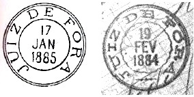
Am Ende des Kaiserreichs erschienen zwei weitere Kreisstempel, zuerst JMG-1445c (Abb. Koester):

JMG-1445c (RK) 1887-1889

Kurz darauf erschien JMG-1445d (Abb. Koester):

JMG-1445d (RK) 1889-1892

Der folgende Stempel JMG-1445e (Abb. aus dem Internet) dürfte bereits republikanisch sein:

JMG-1445e (EB) 1891

James Dingler und Klerman W. Lopes haben in Mute Cancellations of the Brazil Empire / Carimbos Mudos do Brasil Império (Brazil Philatelic Association, Rio de Janeiro, 2000) fünf stumme Stempel aus Juiz de Fora aufgeführt:

BPA 648 (1866ff-1882ff) – 3043 – 3140 – 4052 – 4138 (1868)

Zwei weitere stumme Stempel sind bekannt:

1867 (Samml. Jacques Benchimol)
1878 (Samml. FM)

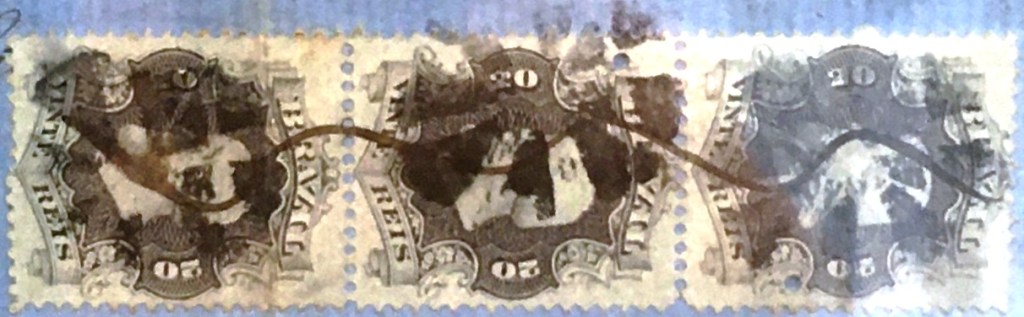
Der Philatelist Fuad Ferreira Fo. zeigte auch einen Einschreibstempel aus Juiz de Fora:

1885 (FF)
Categories
Carimbologia H-L

José Leite (train station/Bahnhof), Rio de Janeiro (JRJ-2320)

Almanak Laemmert, 1892

Other names: Forquilha, Leite de Souza (1936)

See also Forquilha (FRJ-0555)

Forquilha station was opened in January 1886 by the railway company E.F. Sta. Izabel do Rio Preto (Barra Line) in the Município Valença, 180 km north-west of Rio de Janeiro. The station then changed its name twice: in 1889 to José Leite and in 1936 to Leite de Souza. In 1893 the line became the property of V.F. Sapucaí, in 1910 of Rede Sul-Mineira and from 1931 until its closure in 1961 of Rede Mineira de Viação. Today, the tracks have disappeared and the station building serves as a residential building.

Around 1930 (Photo: NN, on estacoesferroviarias.com.br)
In 2016 (Photo: Alexandre Ferreira, on estacoesferroviarias.com.br)

According to the Rio press, there was a post office at the railway station from January 1887:

Jornal do Commercio, 27/01/1887

Paulo Novaes writes on agenciaspostais.com.br that the post office was renamed to José Leite around 1888. The first postmark with the new name JRJ-2320a (fig. Felipe Piccinini) has only shown dates from the Republic:

JRJ-2320a (FP) 1890-1897

R. Koester also shows the postmark with the imperial seal JRJ-2320b in Carimbologia XXV:

JRJ-2320b (RK)

For postmarks with Forquilha see FRJ-0055.

Google Maps

Andere Namen: Forquilha, Leite de Souza (1936)

Siehe auch Forquilha (FRJ-0555)

Der Bahnhof Forquilha (Gabelung) wurde im Januar 1886 von der Eisenbahngesellschaft E.F. Sta. Izabel do Rio Preto (Linie Barra) eröffnet und lag im Município Valença, 180 km nordwestlich von Rio de Janeiro. Danach änderte der Bahnhof zweimal seinen Namen: 1889 in José Leite und 1936 in Leite de Souza. 1893 ging die Strecke in den Besitz der V.F. Sapucaí über, 1910 in den der Rede Sul-Mineira und von 1931 bis zu ihrer Stilllegung 1961 in den der Rede Mineira de Viação. Heute sind die Gleise verschwunden, das Bahnhofsgebäude dient als Wohnhaus.

Um 1930 (Foto: NN, auf estacoesferroviarias.com.br)
2016 (Foto: Alexandre Ferreira, auf estacoesferroviarias.com.br)

Wie aus der Presse in Rio hervorgeht, gab es ab Januar 1887 ein Postamt am Bahnhof:

Jornal do Commercio, 27.01.1887

Paulo Novaes schreibt auf agenciaspostais.com.br, dass bereits um 1888 auch das Postamt zu José Leite umbenannt wurde. Der erste Poststempel mit dem neuen Namen JRJ-2320a (Abb. Felipe Piccinini) zeigte bisher nur Daten aus der Republik:

JRJ-2320a (FP) 1890-1897

R. Koester zeigt in Carimbologia XXV auch den Poststempel mit dem kaiserlichen Siegel JRJ-2320b:

JRJ-2320b (RK)

Für Poststempel mit Forquilha siehe FRJ-0055.

Categories
Carimbologia Q-R

Joinville, Santa Catarina (JSC-0145)

Atlas do Imperio do Brasil, 1868

See also Colonia Dona Francisca (CSC-0055)

The original territory of the Propriedade de D. Francisca e Principe de Joinville was a gift from Emperor D. Pedro II to his sister Francisca and her fiancé, the Prince of Joinville, in May 1843. It was not until March 1851 that immigrants from Europe arrived in the colony of Dona Francisca, the centre of which became the settlement of Joinville in 1852. In April 1858, the village was elevated to the Freguesia de S. Francisco Xavier de Joinville, which belonged to the Vila de S. Francisco and was located on the west bank of the Cachoeira, 180 kilometres north of the provincial capital Desterro (today: Florianópolis). Joinville became a vila in March 1866 and a town in May 1877.

Three dates have been found for the creation of the local post office. The first in June 1857, as shown in the report of the Imperial Ministry for the following year:

Relatorio do Ministerio do Imperio/1858

Then in May 1859, as R. Koester writes in Carimbologia XII. By 1863, however, the post office had already closed again, as it no longer appears in the list of post offices in the province of Santa Catarina. The third opening was decided in January 1867, this time under the place name Joinville, as can be seen from the directory of imperial post offices (Tabella das Agencias do Correio do Imperio, Rio de Janeiro, 1885).

The oldest postmark to date with the place name Joinville is DSC-0085a, which also exists in blue and brown, and which is illustrated in P. Ayres (op. cit.) with no. 1614:

DSC-0085a (P.A. 1614) 1875-1885

This was followed by JSC-0145a (illustration from the Internet), which also exists in blue:

JSC-0145a (EB) 1887-1893

R. Koester shows the postmark with the imperial seal JSC-0145b in Carimbologia XXV:

JSC-0145b (RK)

And James Dingler and Klerman W. Lopes have also listed a mute Joinville postmark in Mute Cancellations of the Brazil Empire / Carimbos Mudos do Brasil Império (Brazil Philatelic Association, Rio de Janeiro, 2000):

BPA 3943

For cancels with Dona Francisca see CSC-0055.

Carta da Republica dos Estados Unidos do Brazil, 1892

Siehe auch Colonia Dona Francisca (CSC-0055)

Das ursprüngliche Gebiet der Propriedade de D. Francisca e Principe de Joinville war eine Schenkung des Kaisers D. Pedro II. im Mai 1843 an seine Schwester Francisca und ihren Verlobten, den Prinzen von Joinville. Erst im März 1851 kamen Einwanderer aus Europa in die Kolonie Dona Francisca, deren Kern 1852 die Siedlung Joinville wurde. Im April 1858 wurde der Ort zur Freguesia de S. Francisco Xavier de Joinville erhoben, die zur Vila de S. Francisco gehörte und am Westufer des Cachoeira, 180 km nördlich der Provinzhauptstadt Desterro (heute: Florianópolis) lag. Joinville wurde im März 1866 zur Vila und im Mai 1877 zur Stadt erhoben.

Für die Gründung des örtlichen Postamtes wurden drei Daten gefunden. Die erste im Juni 1857, wie aus dem Bericht des kaiserlichen Ministeriums für das folgende Jahr hervorgeht:

Relatorio do Ministerio do Imperio/1858

Dann im Mai 1859, wie R. Koester in Carimbologia XII schreibt. Um 1863 war das Postamt jedoch bereits wieder geschlossen, da es im damaligen Verzeichnis der Postämter der Provinz Santa Catarina nicht mehr auftaucht. Die dritte Eröffnung wurde im Januar 1867 beschlossen, diesmal unter dem Ortsnamen Joinville, wie aus dem Verzeichnis der kaiserlichen Postämter (Tabella das Agencias do Correio do Imperio, Rio de Janeiro, 1885) hervorgeht.

Der bisher älteste Poststempel mit Ortsnamen Joinville ist DSC-0085a, den es auch in blau und braun gibt, und der bei P. Ayres (op. cit.) mit der Nr. 1614 abgebildet ist:

DSC-0085a (P.A. 1614) 1875-1885

Es folgte JSC-0145a (Abb. aus dem Internet), den es auch in Blau gibt:

JSC-0145a (EB) 1887-1893

R. Koester zeigt in Carimbologia XXV den Poststempel mit dem kaiserlichen Siegel JSC-0145b:

JSC-0145b (RK)

Und James Dingler und Klerman W. Lopes haben in Mute Cancellations of the Brazil Empire (Carimbos Mudos do Brasil Império, Brazil Philatelic Association, Rio de Janeiro, 2000) auch eine stummen Poststempel aus Joinville aufgeführt:

BPA 3943

Für Poststempel mit dem Ortsnamen Dona Francisca siehe CSC-0055.

Categories
Carimbologia H-L

Joaseiro, Bahia (JBA-0440)

Villiers de l’Ile Adam: Carta(…) da Provincia da Bahia, 1848

Text update on May 22, 2025

Other spellings: Joazeiro, Juazeiro

From 1706, this settlement was an Indian village administered by Franciscans on the south bank of the São Francisco, 500 kilometres northwest of the later provincial capital Salvador da Bahia. From August 1720 it belonged to the Vila de Jacobina, was itself named a Vila in May 1833 and only received the status of a Freguesia de N. Sra das Grotas do Juazeiro in March 1840. Since July 1878, Juazeiro (as it is spelt today) has been a town.

Juazeiro post office, 1957 (Photo: IBGE)

Four dates have been found for the foundation of the local post office. First in March 1836, as noted by Nova Monteiro in Administrações e Agencias Postaes do Brasil Imperio (Brasil Filatelico/RJ, 1934-5; reprint SPP 1994-1999). Then two months later, as R. Koester writes in Carimbologia XXV. The directory of imperial post offices (Tabella das Agencias do Correio do Imperio, Rio de Janeiro, 1885) gives the year 1863, and finally the General Directorate of the Post Office (Diretoria Geral dos Correios) reports in 1894 that a post office was founded in Juazeiro in September 1867. It is certain that a postal employee was appointed for Juazeiro in June 1863:

Diario do Rio de Janeiro, 29/06/1863

The oldest postmark to date is JBA-0440a (fig. Koester, op. cit.):

JBA-0440a (RK) 1850ff

The following French type JBA-0440b (fig. Luciano Gomes) shows the spelling JOAZEIRO:

JBA-0440b (LG) 1877ff

This was followed by the double circle JBA-0440c (fig. Koester), with the spelling Juaseiro:

JBA-0440c (RK) 1879

Then came JBA-0440d (illustration from the Internet):

JBA-0440d (EB) 1886-1892
Atlas do Imperio do Brasil, 1868

Textaktualisierung am 22.05.2025

Andere Schreibweisen: Joazeiro, Juazeiro

Diese Siedlung war ab 1706 ein von Franziskanern verwaltetes Indianerdorf am Südufer des São Francisco, 500 km nordwestlich der späteren Provinzhauptstadt Salvador da Bahia. Ab August 1720 gehörte es zur Vila de Jacobina, wurde im Mai 1833 selbst zur Vila ernannt und erhielt erst im März 1840 den Status einer Freguesia de N. Sra das Grotas do Juazeiro. Seit Juli 1878 ist Juazeiro (wie es heute geschrieben wird) eine Stadt.

Postamt Juazeiro, 1957 (Foto: IBGE)

Für die Gründung des örtlichen Postamtes wurden vier Daten gefunden. Zuerst im März 1836, wie von Nova Monteiro in Administrações e Agencias Postaes do Brasil Imperio (Brasil Filatelico/RJ, 1934-5; Nachdruck SPP 1994-1999) notiert. Dann zwei Monate später, wie R. Koester in Carimbologia XXV schreibt. Im Verzeichnis der kaiserlichen Postämter (Tabella das Agencias do Correio do Imperio, Rio de Janeiro, 1885) liest man dafür das Jahr 1863, schließlich berichtet die Generaldirektion der Post (Diretoria Geral dos Correios) 1894 von einer Postamtsgründung in Juazeiro im September 1867. Sicher ist, dass im Juni 1863 ein Postangestellter für Juazeiro ernannt wurde:

Diario do Rio de Janeiro, 29.06.1863

Der bisher älteste Poststempel ist JBA-0440a (Abb. Koester, op. cit.):

JBA-0440a (RK) 1850ff

Der folgende französische Typ JBA-0440b (Abb. Luciano Gomes) zeigt die Schreibweise JOAZEIRO:

JBA-0440b (LG) 1877ff

Es folgte der Doppelkreis JBA-0440c (Abb. Koester), mit der Schreibweise Juaseiro:

JBA-0440c (RK) 1879

Danach kam JBA-0440d (Abb. aus dem Internet):

JBA-0440d (EB) 1886-1892
Categories
Carimbologia H-L

João Gomes, Minas Gerais (JMG-3360)

Atlas do Imperio do Brasil, 1868

Other names: Palmyra, Santos Dumont (1932)

From November 1728, there was an estate (rancho) belonging to João Gomes Martins on the New Road (Caminho Novo) from Vila Rica to Rio de Janeiro, 170 kilometres south of the later capital Ouro Preto. The settlement became the Distrito de Vila de Barbacena in 1839, the Freguesia de S. Miguel e Almas de João Gomes in December 1867, the Vila de Palmyra in July 1889 and the town in March 1890, which has borne the name of its famous son, the aviation pioneer Alberto Santos Dumont (born 1873), since July 1932, shortly after his voluntary death in a beach hotel in Guarujá.

Alberto Santos Dumont (Photo: Zayda ben Yusuf, 1902)

Nova Monteiro writes in Administrações e Agencias Postaes do Brasil Imperio (Brasil Filatelico/RJ, 1934-5; reprint SPP 1994-1999) that there had been a post office in João Gomes since May 1863. As the Minas Gerais press reported that it reopened in April 1872, it must have been closed before then.

Noticiador de Minas, 20.04.1872

The post office was probably later moved to the railway station of the E.F. D. Pedro II railway company, which opened in February 1877.

Palmyra station, around 1930 (Photo: Jorge A. Ferreira, on estacoesferroviarias.com.br)

In the beginning, the stamps were cancelled by hand (fig. R. Koester, in Carimbologia XXV):

1869-1872 (RK)

Later came the double circle JMG-3360a (fig. Koester):

JMG-3360a (RK) 1875-1877

This was followed by JMG-3360b (ill. José L. Fevereiro):

JMG-3360b (JLF) 1878-1888

At the end of the Empire, JMG-3360c (collect. FM) also appeared:

JMG-3360c (FM) 1889-1894
Villiers de l’Ile Adam: Carta (…) da Provincia de Minas Geraes, 1849

Andere Namen: Palmyra, Santos Dumont (1932)

Seit November 1728 gab es ein Landgut (Rancho) eines João Gomes Martins am Neuen Weg (Caminho Novo) von Vila Rica nach Rio de Janeiro, 170 km südlich der späteren Hauptstadt Ouro Preto. Die Siedlung wurde 1839 zum Distrito de Vila de Barbacena, im Dezember 1867 zur Freguesia de S. Miguel e Almas de João Gomes, im Juli 1889 zur Vila de Palmyra und im März 1890 zur Stadt, die seit Juli 1932 den Namen ihres berühmten Sohnes, des Luftfahrtpioniers Alberto Santos Dumont (geb. 1873) trägt, kurz nach dessen freiwilligem Tod in einem Strandhotel in Guarujá.

Alberto Santos Dumont (Foto: Zayda ben Yusuf, 1902)

Nova Monteiro schreibt in Administrações e Agencias Postaes do Brasil Imperio (Brasil Filatelico/RJ, 1934-5; Reprint SPP 1994-1999), dass es in João Gomes seit Mai 1863 ein Postamt gab. Da die Presse von Minas Gerais von einer Wiedereröffnung im April 1872 berichtete, muss es vorher geschlossen worden sein.

Noticiador de Minas, 20.04.1872

Vermutlich wurde das Postamt später in den Bahnhof der Eisenbahngesellschaft E.F.D. Pedro II verlegt, der im Februar 1877 eröffnet wurde.

Bahnhof Palmyra, um 1930 (Foto: Jorge A. Ferreira, auf estacoesferroviarias.com.br)

Zu Beginn wurden die Marken noch per Hand entwertet (Abb. R. Koester, in Carimbologia XXV):

1869-1872 (RK)

Später kam der Doppelkreis JMG-3360a (Abb. Koester):

JMG-3360a (RK) 1875-1877

Es folgte JMG-3360b (Abb. José L. Fevereiro):

JMG-3360b (JLF) 1878-1888

Am Ende des Kaiserreichs erschien auch JMG-3360c (Samml. FM):

JMG-3360c (FM) 1889-1894
Categories
Carimbologia H-L

João Ayres (train station/Bahnhof), Minas Gerais (JMG-1440)

Estações (…) do Rio de Janeiro, São Paulo e Minas Geraes, 1880

João Ayres station was opened in June 1878 by the railway company E.F.D. Pedro II (Center Line) in the Município de Barbacena, 150 km south of the provincial capital Ouro Preto. João Ayres Gomes was a major landowner in the region. The railway line was transferred to E.F. Central do Brasil in 1889 and belonged to Rede Ferroviária Federal S.A. (estacoesferroviarias.com.br) from 1975 until it was closed in 1996. Today the tracks are still there, the station building is an abandoned ruin.

Around 1930 (photo: estacoesferroviarias.com.br)
In April 2022 (Photo: Christoffer R., on Google Maps)

The station area belonged to the Distrito de Curral Novo from September 1891, 4 years later to the Distrito de Bias Fortes, from December 1938 to the Distrito de Sítio, and since December 1948 it has been part of the Município de Antonio Carlos.

Two dates have been found for the foundation of the station post office. Both Paula Sobrinho (História Postal de Minas Gerais, Belo Horizonte, 1997) and R. Koester (Carimbologia XXV) write of July 1881, but the Rio press reported it as early as 1879:

Jornal do Commercio/RJ, 11/02/1879

The later date presumably refers to the operation begin of the railway station post office. The oldest postmark to date is JMG-1440a (image from the Internet):

JMG-1440a (EB) 1883ff-1884

This was followed by JMG-1440b (ill. by Felipe Piccinini), which also occurs in turquoise blue:

JMG-1440b (FP) 1886-1891
Estado de Minas Geraes, 1910

Der Bahnhof João Ayres wurde im Juni 1878 von der Eisenbahngesellschaft E.F.D. Pedro II (Hauptlinie) eröffnet und lag im Município de Barbacena, 150 km südlich der Provinzhauptstadt Ouro Preto. João Ayres Gomes war Großgrundbesitzer in der Region. Die Bahnlinie ging 1889 an die E.F. Central do Brasil über und gehörte von 1975 bis zu ihrer Stilllegung 1996 der Rede Ferroviária Federal S.A. (estacoesferroviarias.com.br). Heute sind die Gleise noch vorhanden, das Bahnhofsgebäude ist eine verlassene Ruine.

Um 1930 (Foto: estacoesferroviarias.com.br)
Im April 2022 (Foto: Christoffer R., auf Google Maps)

Das Bahnhofsgelände gehörte ab September 1891 zum Distrito de Curral Novo, 4 Jahre später zum Distrito de Bias Fortes, ab Dezember 1938 zum Distrito de Sítio, seit Dezember 1948 liegt es im Município de Antonio Carlos.

Für die Gründung des Bahnhofspostamtes wurden zwei Daten gefunden. Sowohl Paula Sobrinho (História Postal de Minas Gerais, Belo Horizonte, 1997) als auch R. Koester (Carimbologia XXV) schreiben von Juli 1881. Die Presse von Rio berichtete jedoch bereits 1879 darüber:

Jornal do Commercio/RJ, 11.02.1879

Vermutlich handelt es sich bei dem späteren Datum um die Inbetriebnahme des Bahnhofspostamtes. Der bisher älteste Poststempel ist JMG-1440a (Abb. aus dem Internet):

JMG-1440a (EB) 1883ff-1884

Es folgte JMG-1440b (Abb. Felipe Piccinini), der auch in türkisblau vorkommt:

JMG-1440b (FP) 1886-1891
Categories
Carimbologia H-L

João Amaro (da Tapera), Bahia (JBA-0435)

Atlas do Imperio do Brasil, 1868

From May 1862 João Amaro was a district of the Vila de Tapera on the east bank of the Paraguaçu, 300 kilometres west of the provincial capital Salvador da Bahia. In May 1881, the village became the Freguesia de Sto. Antonio do João Amaro, but moved to the Município de Jibóia as a distrito in August 1892. Further changes in the respective municípios followed: in August 1899 to Monte Cruzeiro, in July 1921 again to Tapera, in July 1928 to Santa Terezinha and since August 1958 João Amaro has been a distrito in the Município de Iaçu. João Amaro Maciel Parente was a pioneer (sertanista) who explored the area at the end of the 17th century.

As reported in the Rio press, it was decided in August 1884 to set up a post office there:

Gazeta de Noticias/RJ, 09/08/1884

The establishment of the post office is presumably connected with the opening of a railway station of the E.F. Central da Bahia railway company (southern line) in October 1883, even if this is not officially mentioned.

The oldest postmark to date is JBA-0435a (image from the Internet):

JBA-0435a (EB) 1891
Rede Ferroviária da Bahia, 1898 (IBGE)

Seit Mai 1862 war João Amaro ein Distrito der Vila de Tapera am Ostufer des Paraguaçu, 300 km westlich der Provinzhauptstadt Salvador da Bahia. Im Mai 1881 wurde der Ort zur Freguesia de Sto. Antonio do João Amaro, wechselte aber im August 1892 als Distrito zum Município de Jibóia. Weitere Wechsel in den zuständigen Municípios folgten: im August 1899 zu Monte Cruzeiro, im Juli 1921 wieder zu Tapera, im Juli 1928 zu Santa Terezinha und seit August 1958 ist João Amaro ein Distrito im Município de Iaçu. João Amaro Maciel Parente war ein Pionier (Sertanista), der das Gebiet Ende des 17. Jahrhunderts erforschte.

Wie die Presse in Rio berichtete, wurde im August 1884 beschlossen, dort ein Postamt einzurichten:

Gazeta de Noticias/RJ, 09.08.1884

Vermutlich hängt die Gründung des Postamtes mit der Eröffnung eines Bahnhofs der Eisenbahngesellschaft E.F. Central da Bahia (Südlinie) im Oktober 1883 zusammen, auch wenn dies nicht offiziell erwähnt wird.

Der bisher älteste Poststempel ist JBA-0435a (Abb. aus dem Internet):

JBA-0435a (EB) 1891
Categories
Carimbologia H-L

Jerumenha, Piauí (JPI-0240)

Villiers de l’Ile Adam: Carta (…) da Provincia do Piauhy, 1850

Other names: Sto. Antonio da Gurgueia, Jeromenha, Jurumenha

Jerumenha (also spelt Jeromenha or Jurumenha) has been mentioned since 1676 as Arraial, at that time of the Capitania de Pernambuco, on the east bank of the Gurgueia, 310 south of the later provincial capital of Piauí, Teresina. In 1740, the village became the Freguesia de Sto. Antonio da Gurgueia, which became a vila called Jerumenha in June 1761 and a town in December 1890.

Three dates have been found for the creation of the local post office. R. Koester (Carimbologia XXV) mentions the year 1824, the RHM catalogue gives the exact date 13.05.1843 and the directory of imperial post offices (Tabella das Agencias do Correio do Imperio, Rio de Janeiro, 1885) writes the year 1881. However, since Nova Monteiro (Administrações e Agencias Postaes do Brasil Imperio, in Brasil Filatelico/RJ, 1934-5; reprint SPP 1994-1999) writes that a postal clerk was appointed for Jerumenha in May 1842, these opening dates are either incorrect or incomplete.

The oldest postmark to date is JPI-0240a (fig. RHM catalogue):

JPI-0240a (RHM P-PI-01) 1843ff

JPI-0240c was only found before the end of the century (fig. Koester, op. cit.):

JPI-0240c (RK) 1891
Atlas do Imperio do Brasil, 1868

Andere Namen: Sto. Antonio da Gurgueia, Jeromenha, Jurumenha

Jerumenha (auch Jeromenha oder Jurumenha geschrieben) wird seit 1676 als Arraial noch in der Capitania de Pernambuco am Ostufer des Gurgueia, 310 südlich der späteren Provinzhauptstadt von Piauí, Teresina, erwähnt. 1740 wurde der Ort zur Freguesia de Sto. Antonio da Gurgueia, die im Juni 1761 zur Vila de Jerumenha und im Dezember 1890 zur Stadt erhoben wurde.

Für die Gründung des örtlichen Postamtes wurden drei Daten gefunden. R. Koester (Carimbologia XXV) nennt das Jahr 1824, der RHM-Katalog gibt das genaue Datum 13.05.1843 an und im Verzeichnis der kaiserlichen Postämter (Tabella das Agencias do Correio do Imperio, Rio de Janeiro, 1885) findet sich das Jahr 1881. Da jedoch Nova Monteiro (Administrações e Agencias Postaes do Brasil Imperio, in Brasil Filatelico/RJ, 1934-5; Reprint SPP 1994-1999) schreibt, dass ein Postbeamter für Jerumenha im Mai 1842 ernannt wurde, sind diese Eröffnungsdaten entweder falsch oder unvollständig.

Der bisher älteste Poststempel ist JPI-0240a (Abb. RHM-Katalog):

JPI-0240a (RHM P-PI-01) 1843ff

Erst vor dem Ende des Jahrhunderts fand sich auch JPI-0240c (Abb. Koester, op. cit.):

JPI-0240c (RK) 1891
Categories
Carimbologia H-L

Jequitibá, Minas Gerais (JMG-1430)

Atlas do Imperio do Brasi, 1868

Other names: Trindade, Barra do Jequitibá

The Arraial de Trindade had existed since December 1849, belonged to the Vila de Sabará and was located at the mouth of the Jequitibá into the Rio das Velhas, 200 kilometres northwest of the provincial capital Ouro Preto. In May 1856 Jequitibá became a Distrito, now subordinate to the Vila de Sete Lagoas, and in June 1858 the Freguesia de Santíssimo Sacramento da Barra do Jequitibá. Jequitibá has been an independent município since December 1948.

Paula Sobrinho (História Postal de Minas Gerais, Belo Horizonte, 1997) and R. Koester (Carimbologia XXV) agree that there has been a post office there since November 1881. This is confirmed by the press in Rio:

Jornal do Commercio/RJ, 12/11/1881

The imperial postmark is JMG-1430a (fig. Koester, op. cit.):

JMG-1430a (RK) 1889-1894ff
Villiers de l’Ile Adam: Carta (…) da Provincia de Minas Geraes, 1849

Andere Namen: Trindade, Barra do Jequitibá

Der Arraial de Trindade bestand seit Dezember 1849, gehörte zur Vila de Sabará und lag an der Mündung des Jequitibá in den Rio das Velhas, 200 km nordwestlich der Provinzhauptstadt Ouro Preto. Im Mai 1856 wurde Jequitibá ein Distrito, nun der Vila de Sete Lagoas untergeordnet, im Juni 1858 die Freguesia de Santíssimo Sacramento da Barra do Jequitibá. Seit Dezember 1948 ist Jequitibá ein eigenständiges Município.

Paula Sobrinho (História Postal de Minas Gerais, Belo Horizonte, 1997) und R. Koester (Carimbologia XXV) sind sich einig, dass es dort seit November 1881 ein Postamt gab. Dies wird von der Presse in Rio bestätigt:

Jornal do Commercio/RJ, 12.11.1881

Der kaiserliche Poststempel ist JMG-1430a (Abb. Koester, op. cit.):

JMG-1430a (RK) 1889-1894ff
Categories
Carimbologia H-L

Jequitahy, Minas Gerais (JMG-1428)

Atlas do Imperio do Brasil, 1868

See also Bomfim de Montes Claros (BMG-0370)

The history of this village is linked to that of Bomfim de Montes Claros (now Bocaiúva), 100 kilometres to the east. The Arraial de N. Sra. da Conceição do Jequitahy was founded around 1850, belonged to the Vila de Montes Claros and was located on the north bank of the Jequitaí, 500 km north of the provincial capital Ouro Preto. In November 1873, it was incorporated as a freguesia into the newly founded Vila de Jequitahy in Bonfim de Montes Claros. In October 1881, the seat of the Vila was moved to N. Sra. da Conceição do Jequitahy, which was elevated to city status three years later. In April 1890, it was downgraded to the Distrito de Vila Nova de Jequitahy, again subordinate to the Município de Montes Claros. Since December 1948, Jequitaí (as it is spelt today) has once again been an independent município. In the indigenous language, the place name means fish basket by the river of stones.

As Paula Sobrinho writes in História Postal de Minas Gerais (Belo Horizonte, 1997), there had been a post office there since July 1879; the oldest postmark to date is JMG-1428a (collect. Fuad Ferreira Fo.):

JMG-1428a (FF) 1885-1890
Carta da Republica dos Estados Unidos do Brazil, 1892

Siehe auch Bomfim de Montes Claros (BMG-0370)

Die Geschichte dieses Ortes ist mit der des 100 km östlich gelegenen Bomfim de Montes Claros (heute Bocaiúva) verbunden. Der Arraial de N. Sra. da Conceição do Jequitahy entstand um 1850, gehörte zur Vila de Montes Claros und lag am Nordufer des Jequitaí, 500 km nördlich der Provinzhauptstadt Ouro Preto. Im November 1873 wurde es als Freguesia in die neu gegründete Vila de Jequitahy in Bonfim de Montes Claros eingegliedert. Im Oktober 1881 wurde der Sitz der Vila nach N. Sra. da Conceição do Jequitahy verlegt, das drei Jahre später zur Stadt erhoben wurde. Im April 1890 erfolgte die Herabstufung zum Distrito de Vila Nova de Jequitahy, wieder untergeordnet zum Município de Montes Claros. Seit Dezember 1948 ist Jequitaí (wie es heute geschrieben wird) wieder ein eigenständiges Município. Der Ortsname bedeutet in der indigenen Sprache Fischkorb am Fluss der Steine.

Wie Paula Sobrinho in História Postal de Minas Gerais (Belo Horizonte, 1997) schreibt, gibt es dort seit Juli 1879 ein Postamt; der bisher älteste Poststempel ist JMG-1428a (Samml. Fuad Ferreira Fo.):

JMG-1428a (FF) 1885-1890