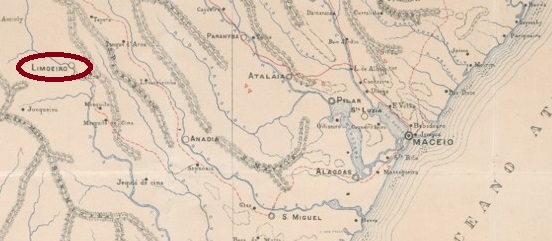
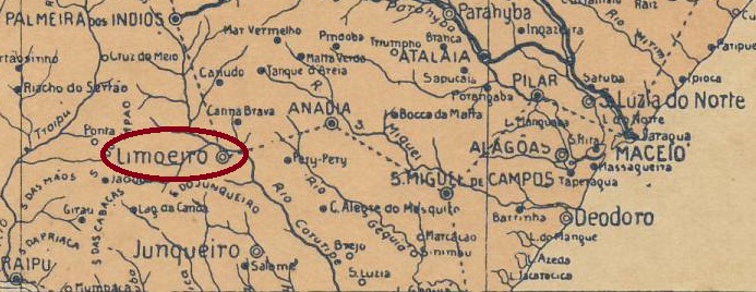
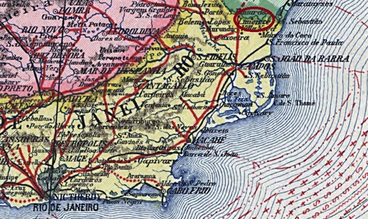
The Freguesia de N. Sra. da Conceição do Limoeiro, which had existed since June 1865, belonged to the Vila de Anadia and was located on the north bank of the Coruripe, 110 kilometres west of the provincial capital Maceió. In May 1882 it was elevated to a Vila, and since December 1943 the Município has been called Limoeiro de Anadia, probably to avoid confusion with other Limoeiros in Brazil.
Aldo Cardoso writes in Contribuição para a História dos Correios de Alagoas (Maceió, 1969) that there had been a post office there since 1876. The oldest postmark to date is LAL-0100b (illustration by Aldo Cardoso):
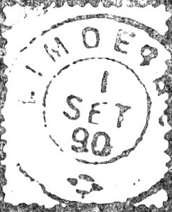
LAL-0100b (AC) 1887-1890
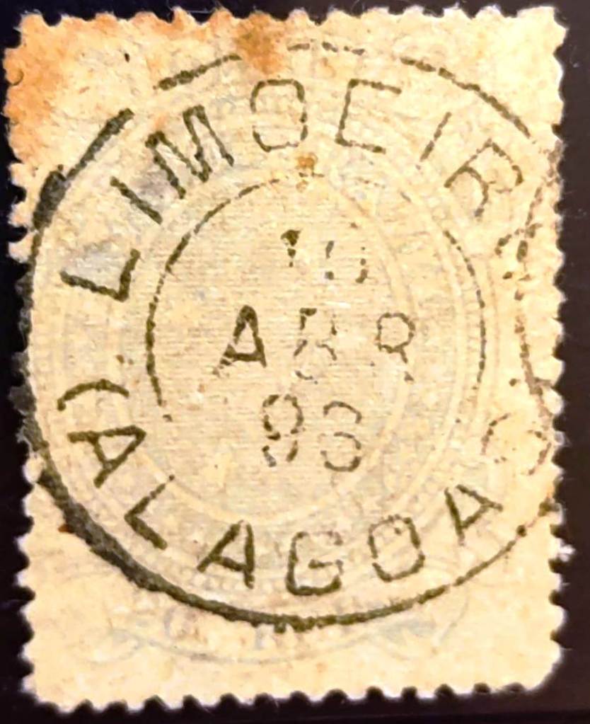
LAL-0100c also appeared at the beginning of the Republic (illustration by Jorge L. Pedreira):
LAL-0100c (JLP) 1893Arthur D. Ribeiro: Estado de Alagoas, 1923
Andere Namen: Limoeiro de Anadia (1943)
Die seit Juni 1865 bestehende Freguesia de N. Sra. da Conceição do Limoeiro gehörte zur Vila de Anadia und lag am Nordufer des Coruripe, 110 km westlich der Provinzhauptstadt Maceió. Im Mai 1882 wurde sie zur Vila erhoben, seit Dezember 1943 heißt der Município Limoeiro de Anadia, wohl um Verwechslungen mit anderen Limoeiros in Brasilien zu vermeiden.
Aldo Cardoso schreibt in Contribuição para a História dos Correios de Alagoas (Maceió, 1969), dass es dort seit 1876 ein Postamt gab. Der bisher älteste Poststempel ist LAL-0100b (Abb. Aldo Cardoso):
LAL-0100b (AC) 1887-1890
Am Anfang der Republik erschien auch LAL-0100c (Abb. Jorge L. Pedreira):
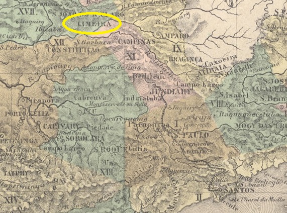
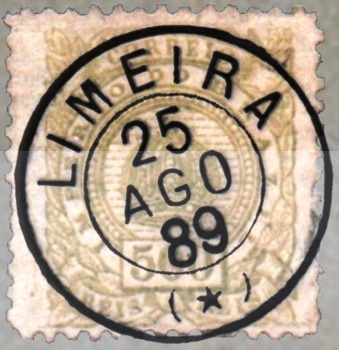
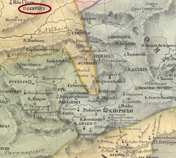
The Rancho da Limeira cattle station had existed since 1824 on the Morro Azul (Blue Mountain), more precisely on the west bank of the Ribeirão do Tatu (Armadillo Stream), 170 kilometres northwest of the provincial capital of São Paulo. The village became the Freguesia de N. Sra. das Dores do Tatuhiby in December 1830 and belonged to the Vila de Constituição (now Piracicaba) until March 1842, when the Vila de N. Sra. das Dores de Limeira was proclaimed. Limeira has been a town since April 1863.
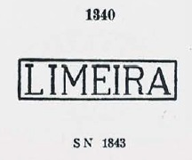
As Nova Monteiro writes in Administrações e Agencias Postaes do Brasil Imperio (Brasil Filatelico/RJ, 1934-5; reprint SPP 1994-1999), a post office existed in the town since January 1832, but since the Directory of Imperial Post Offices (Tabella das Agencias do Correio do Imperio, Rio de Janeiro, 1885) indicates the opening of the post office for 1844, it had closed in the meantime. The oldest postmark to date is LSP-0765a, which was given the number 1340 in P. Ayres’ Catálogo de Carimbos Brasil-Império (S. Paulo, 1937, 1942):
LSP-0765a (P.A. 1340) 1843ff
Then came the smaller cancel variant LSP-0765b, as R. Koester shows in Carimbologia XXVI:
LSP-0765b (RK) 1850ff
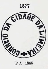
Two peculiar cancellations followed, beginning with LSP-0765c, which also occurs in brown, red and blue and was given the no. 1577 by P. Ayres (op. cit.):
LSP-0765c (P.A. 1577) 1864-1871
LSP-0765d was also presented by P. Ayres:
LSP-0765d (P.A. p. 122) 1874-1876
Shortly afterwards, the stamps in Limeira were also cancelled by hand, as the illustration from the Fuad Ferreira Fo. collection shows:
1877 (FF)
This was followed by the double circle cancellation LSP-0765e (illustration by Luiz C. Fritzen):
LSP-0765e (LCF) 1878-1888
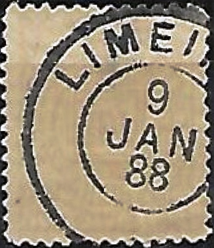
At the end of the Empire, the French type LSP-0765f also appeared (illustration by Walter Sonnenberg):
LSP-0765f (WS) 1889-1895
The beautiful LSP-0765g registered postmark in violet comes from the Klerman Lopes collection:
LSP-0765g (KL) 1883
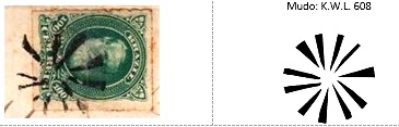
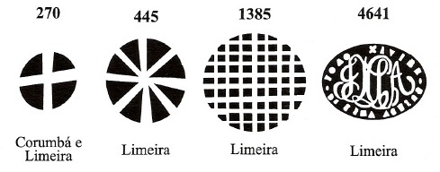
Klerman W. Lopes and James Dingler have listed four mute postmarks from Limeira in Mute Cancellations of the Brazil Empire/ Carimbos Mudos do Brasil Império (Brazil Philatelic Association, Rio de Janeiro, 2000):
BPA 270 – 445 (1879) – 1385 (1882) – 4641 (1883)
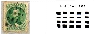
The philatelist Mário Celso Orsi Jr. was able to assign two further postmarks from the same work to Limeira:
BPA 2982 (MO) 1868BPA 608 (MO) 1878
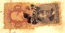
José L. Fevereiro found another mute postmark for Limeira:
1876 (JLF)Villiers de l’Ile Adam: Carta (…) da Provincia de São Paulo, 1847
Andere Namen: Rancho da Limeira, Dores do Tatuhiby
Seit 1824 bestand die Viehstation Rancho da Limeira am Morro Azul (Blauer Berg), genauer am Westufer des Ribeirão do Tatu (Gürteltierbach), 170 km nordwestlich der Provinzhauptstadt São Paulo. Der Ort wurde im Dezember 1830 zur Freguesia de N. Sra. das Dores do Tatuhiby und gehörte bis März 1842 zur Vila de Constituição (heute Piracicaba), als die Vila de N. Sra. das Dores de Limeira ausgerufen wurde. Seit April 1863 ist Limeira eine Stadt.
Wie Nova Monteiro in Administrações e Agencias Postaes do Brasil Imperio (Brasil Filatelico/RJ, 1934-5; Reprint SPP 1994-1999) schreibt, existierte ein Postamt am Ort seit Januar 1832, aber da das Verzeichnis der kaiserlichen Postämter (Tabella das Agencias do Correio do Imperio, Rio de Janeiro, 1885) die Eröffnung des Postamtes für 1844 angibt, war es zwischenzeitlich geschlossen. Der bisher älteste Poststempel ist LSP-0765a, der in P. Ayres‘ Catálogo de Carimbos Brasil-Império (S. Paulo, 1937, 1942) die Nr. 1340 erhielt:
LSP-0765a (P.A. 1340) 1843ff
Danach kam die kleinere Stempelvariante LSP-0765b, wie R. Koester in Carimbologia XXVI schreibt:
LSP-0765b (RK) 1850ff
Es folgten zwei eigentümliche Stempel, beginnend mit LSP-0765c, der auch in braun, rot und blau vorkommt und von P. Ayres (op. cit.) die Nr. 1577 erhielt:
LSP-0765c (P.A. 1577) 1864-1871
LSP-0765d wurde ebenfalls von P. Ayres vorgestellt:
LSP-0765d (P.A. S. 122) 1874-1876
Kurz danach wurden die Marken in Limeira auch von Hand entwertet, wie die Abbildung aus der Sammlung Fuad Ferreira Fo. zeigt:
1877 (FF)
Es folgte der Doppelkreisstempel LSP-0765e (Abbildung Luiz C. Fritzen):
LSP-0765e (LCF) 1878-1888
Am Ende des Kaiserreichs erschien auch der französische Typ LSP-0765f (Abb. Walter Sonnenberg):
LSP-0765f (WS) 1889-1895
Aus der Sammlung Klerman Lopes stammt der schöne Einschreibstempel LSP-0765g in violett:
LSP-0765g (KL) 1883
Klerman W. Lopes und James Dingler haben in Mute Cancellations of the Brazil Empire/ Carimbos Mudos do Brasil Império (Brazil Philatelic Association, Rio de Janeiro, 2000) vier stumme Poststempel aus Limeira aufgeführt :
BPA 270 – 445 (1879) – 1385 (1882) – 4641 (1883)
Zwei weitere Stempel aus demselben Werk konnte der Philatelist Mário Celso Orsi Jr. Limeira zuordnen :
BPA 2982 (MO) 1868BPA 608 (MO) 1878
Ein weiterer stummer Poststempel hat José L. Fevereiro für Limeira gefunden:
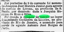
Here we have another place that has since disappeared from the map. According to research by R. Koester (Brasil Filatelico 124, 1959), Cachoeira da Limeira was founded by a certain Dr. Maria Angelica de Abreu e Lima, a Fazendeira from Minas Gerais, who had her estate on the banks of the Itabapoana opposite the Cachoeira do Inferno (Hell’s Waterfall) in Município of Campos, 350 km northeast of the capital Rio de Janeiro. A river port developed, the Porto da Limeira, which quickly became prosperous through trade.
The economic decline of Cachoeira da Limeira was initiated from 1872 by the construction of the railway lines of the E.F. de Macaé e Campos and the E.F. de Carangola, which did not provide for a railway station for this village, as Paulo Novaes writes in agenciaspostais.com.br. All that remains of the original village today are ruins and a few fishermen’s houses. The waterfalls have also disappeared because a dam was built starting in 2007.
As the Rio press reports, there was a post office there from March 1864:
Diario do Rio de Janeiro, 12.03.1864
This was closed by 1884, as it is no longer listed in the Directory of Imperial Post Offices (Tabella das Agencias do Correio do Imperio, Rio de Janeiro, 1885). According to Paulo Novaes (agenciaspostais.com.br), a post office was opened under Limeira do Itabapoanna around 1885, which was closed in October 1910. The only postmark in the 19th century to date is LRJ-0692a (collect. Fuad Ferreira Fo.):
LRJ-0692a (FF) 1892
For postmarks with Cachoeira da Limeira, see CRJ-0025.
Carta da republica dos Estados Unidos do Brazil, 1892
Andere Namen: Porto da Limeira
Siehe auch Cachoeira da Limeira (CRJ-0025)
Hier haben wir einen weiteren Ort, der inzwischen von der Landkarte verschwunden ist. Nach Recherchen von R. Koester (Brasil Filatelico 124, 1959) wurde Cachoeira da Limeira von einer gewissen Dr. Maria Angelica de Abreu e Lima, einer Fazendeira aus Minas Gerais, gegründet, die ihr Landgut am Südufer des Itabapoana gegenüber der Cachoeira do Inferno (Höllenwasserfall), im Município von Campos, 350 km nordöstlich der Hauptstadt Rio de Janeiro, hatte. Es entstand ein Flusshafen, der Porto da Limeira, der durch den Handel schnell zu Wohlstand kam.
Der wirtschaftliche Niedergang von Cachoeira da Limeira wurde ab 1872 durch den Bau der Eisenbahnlinien der E.F. de Macaé e Campos und der E.F. de Carangola eingeleitet, die für diesen Ort keinen Bahnhof vorsahen, wie Paulo Novaes in agenciaspostais.com.br schreibt. Vom ursprünglichen Dorf sind heute nur noch Ruinen und einige Fischerhäuser übriggeblieben. Auch die Wasserfälle sind verschwunden, weil ab 2007 ein Staudamm gebaut wurde.
Wie die Presse von Rio berichtet, gab es dort ab März 1864 ein Postamt:
Diario do Rio de Janeiro, 12.03.1864
Dieses wurde bis 1884 geschlossen, da es im Verzeichnis der kaiserlichen Postämter (Tabella das Agencias do Correio do Imperio, Rio de Janeiro, 1885) nicht mehr aufgeführt ist. Laut Paulo Novaees (agenciaspostais.com.br) wurde ein Postamt unter Limeira do Itabapoana um 1885 eröffnet, das im Oktober 1910 geschlossen wurde. Der bisher einzige Poststempel im 19. Jahrhundert ist LRJ-0692a (Samml. Fuad Ferreira Fo.):
LRJ-0692a (FF) 1892
Für Poststempel mit Cachoeira da Limeira siehe CRJ-0025.
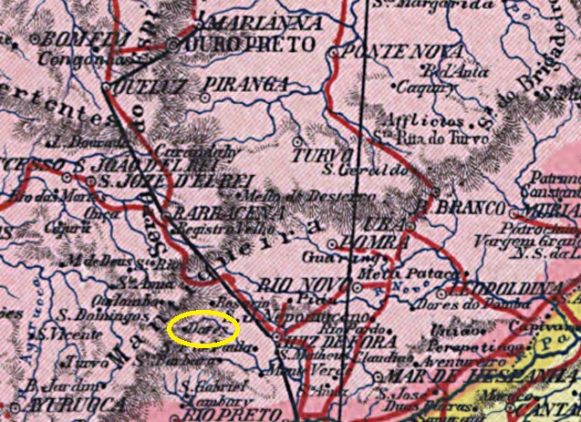
N. Sra. das Dores do Rio do Peixe had been a distrito of the Vila de Barbacena since 1839 and was located on the east bank of the Rio do Peixe, 250 kilometres south of the provincial capital Ouro Preto. The village became a freguesia in June 1859, an independent vila in October 1881 and a town in October 1884, which was given the name Lima Duarte. The Vicomte de Lima Duarte, born as José Rodrigues de Lima Duarte (1826-1896), was a doctor and politician from Barbacena.
Two foundation dates have been found for the local post office. The first in September 1866, as Nova Monteiro writes in Administrações e Agencias Postaes do Brasil Imperio (Brasil Filatelico/RJ, 1934-5; reprint SPP 1994-1999) and Paula Sobrinho in História Postal de Minas Gerais (Belo Horizonte, 1997). The agency is mentioned in the Directory of Imperial Post Offices (Tabella das Agencias do Correio do Imperio, Rio de Janeiro, 1885) with creation year 1872.
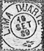
The first postmark with Lima Duarte is LMG-1505a (fig. R. Koester) and appeared around 1889:
LMG-1505a (RK) 1889-1893ff
For postmarks with Dores do Rio do Peixe see DMG-1080.
Carta da Republica dos Eestados Unidos do Brazil, 1892
Andere Namen: Rio do Peixe, Dores do Rio do Peixe
N. Sra. das Dores do Rio do Peixe war seit 1839 ein Distrito der Vila de Barbacena und lag am Ostufer des Rio do Peixe, 250 km südlich der Provinzhauptstadt Ouro Preto. Der Ort wurde im Juni 1859 eine Freguesia, im Oktober 1881 eine eigenständige Vila und im Oktober 1884 eine Stadt, die den Namen Lima Duarte erhielt. Der Vicomte de Lima Duarte, geboren als José Rodrigues de Lima Duarte (1826-1896), war ein Arzt und Politiker aus Barbacena.
Für das örtliche Postamt wurden zwei Gründungsdaten gefunden. Die erste im September 1866, wie Nova Monteiro in Administrações e Agencias Postaes do Brasil Imperio (Brasil Filatelico/RJ, 1934-5; Reprint SPP 1994-1999) und Paula Sobrinho in História Postal de Minas Gerais (Belo Horizonte, 1997) schreiben. Ab 1872 wird die Agentur im Verzeichnis der Kaiserlichen Postämter (Tabella das Agencias do Correio do Imperio, Rio de Janeiro, 1885) erwähnt.
Der erste Poststempel mit Lima Duarte ist LMG-1505a (Abb. R. Koester) und erschien um 1889:
LMG-1505a (RK) 1889-1893ff
Für Poststempel mit Dores do Rio do Peixe siehe DMG-1080.
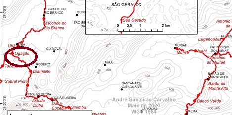
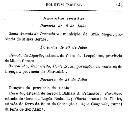
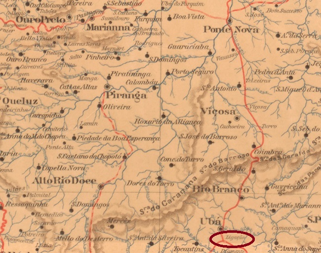
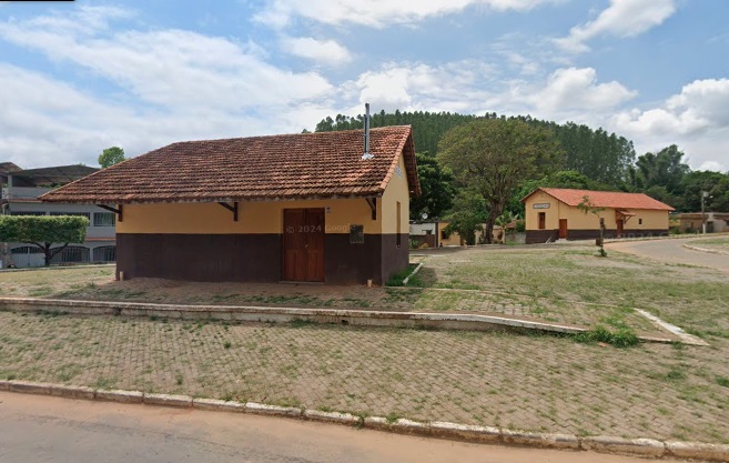
Ligação (Connection) was the name of the station that was opened in February 1880 (according to Paula Sobrinho) or in July 1886 (according to estacoesferroviarias.com.br) by the railway company E.F. Leopoldina (Caratinga Line) in the Município de Ubá, 160 km south-east of the provincial capital Ouro Preto. From 1975 until its closure in 1996, the line belonged to Rede Ferroviária Federal S.A. (estacoesferroviarias.com.br). Today, the tracks have disappeared and the station building is a cultural and leisure centre for the municipality.
In November 2023 (Google Street View)
Paula Sobrinho (História Postal de Minas Gerais, Belo Horizonte, 1997) and R. Koester (Carimbologia XXVI) agree that there has been a post office there since July 1889. This is confirmed by the postal bulletin (Boletim Postal) of that year:
Boletim Postal No. 4 (August 1889)
The oldest postmark to date is LMG-1500a (fig. Luiz C. Fritzen) and already bears a date from the 20th century:
LMG-1500a (LCF) 1904Estado de Minas Geraes, 1910
Ligação (Verbindung) war der Name des Bahnhofs, der im Februar 1880 (nach Paula Sobrinho) oder im Juli 1886 (nach estacoesferroviarias.com.br) von der Eisenbahngesellschaft E.F. Leopoldina (Caratinga-Linie) im Município de Ubá, 160 km südöstlich der Provinzhauptstadt Ouro Preto, eröffnet wurde. Von 1975 bis zu ihrer Stilllegung 1996 gehörte die Strecke der Rede Ferroviária Federal S.A. (estacoesferroviarias.com.br). Heute sind die Gleise verschwunden, das Bahnhofsgebäude ist ein Kultur- und Freizeitzentrum der Gemeinde.
Im November 2023 (Google Street View)
Paula Sobrinho (História Postal de Minas Gerais, Belo Horizonte, 1997) und R. Koester (Carimbologia XXVI) sind sich einig, dass es dort seit Juli 1889 ein Postamt gab. Dies wird durch das Postbulletin (Boletim Postal) des Jahres bestätigt:
Boletim Postal Nr. 4 (August 1889)
Der bisher älteste Poststempel ist LMG-1500a (Abb. Luiz C. Fritzen) und trägt bereits ein Datum aus dem 20. Jahrhundert:
Carta da Republica dos Estados Unidos do Brazil, 1892
Other names: Sacco, Parnamirim (1943)
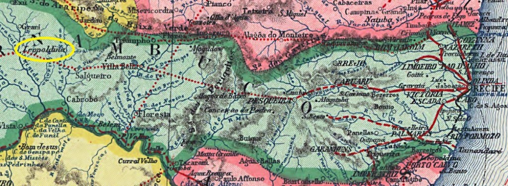
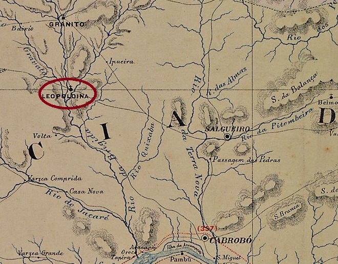
The Freguesia de Sant’Anna do Sacco had existed since June 1867, belonged to the Vila de Cabrobó and was located on the east bank of the Riacho da Brígida, 560 km west of the provincial capital Recife. In May 1870 it became a Freguesia de Leopoldina, in June 1879 a Vila and in July 1909 a town. In March 1934, Leopoldina was downgraded to a Distrito in the Município de Granito. As such, it was transferred to the Município de Bodocó in March 1938. It was not until December 1938 that Leopoldina became a município again, which was renamed five years later to what is now Parnamirim.
As can be seen from the list of imperial post offices (Tabella das Agencias do Correio do Imperio, Rio de Janeiro, 1885), there had been a post office there since 1877. The only postmark from 19th century to date is LPE-0375b (Fig. R. Koester in Carimbologia XXVI):
LPE-0375b (RK) 1891Carta Corographica da Provincia de Pernambuco, 1880
Andere Namen: Sacco, Parnamirim (1943)
Die Freguesia de Sant‘Anna do Sacco bestand seit Juni 1867, gehörte zur Vila de Cabrobó und lag am Ostufer des Riacho da Brígida, 560 km westlich der Provinzhauptstadt Recife. Im Mai 1870 wurde es zur Freguesia de Leopoldina, im Juni 1879 zur Vila und im Juli 1909 zur Stadt. Im März 1934 wurde Leopoldina zu einem Distrito im Município de Granito herabgestuft. Als solcher wechselte es im März 1938 zum Município de Bodocó. Erst im Dezember 1938 wurde Leopoldina wieder ein Município, das fünf Jahre später in das heutige Parnamirim umbenannt wurde.
Wie aus dem Verzeichnis der kaiserlichen Postämter (Tabella das Agencias do Correio do Imperio (Rio de Janeiro, 1885) hervorgeht, gab es dort ein Postamt seit 1877. Der bisher älteste Poststempel ist LPE-0375b (Abb. R. Koester in Carimbologia XXVI):
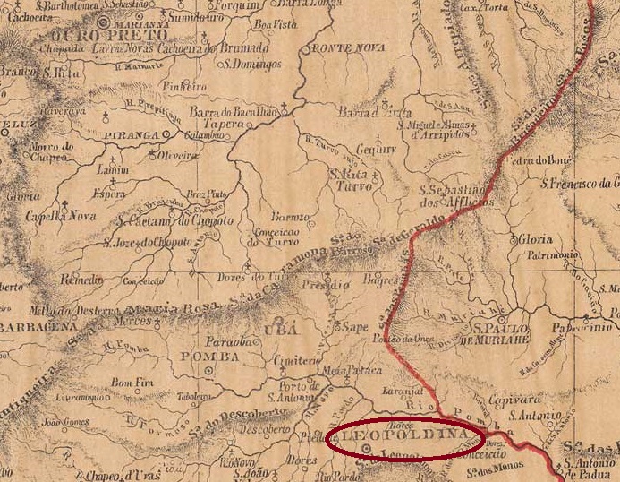
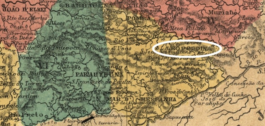
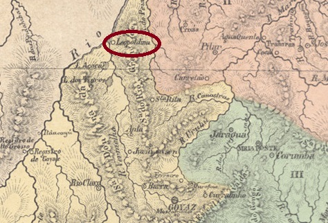
The village was originally called Distrito de S. Sebastião do Feijão Cru (Raw Beans), belonged to Vila de Mar d’Hespanha and was located 250 km south-east of the provincial capital Ouro Preto. In April 1854, it became both Vila and Freguesia de Leopoldina. Leopoldina has been a town since October 1861.
Two dates were found for the founding of the local post office. Firstly in March 1857, as Nova Monteiro writes in Administrações e Agencias Postaes do Brasil Imperio (Brasil Filatelico/RJ, 1934-5; reprint SPP 1994-1999). Then 6 months later, as shown in História Postal de Minas Gerais (Belo Horizonte, 1997) by Paula Sobrinho.
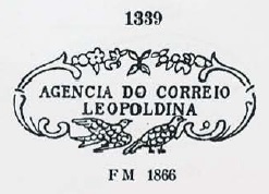
Unfortunately, we only have a description of the oldest postmark LMG-1495a by R. Koester in Carimbologia XXVI, a green-blue double circle on a D. Pedro issue of 1866 with the inscription Cidade LEOPOLDINA between the circles and MINAS in the centre.
This was followed by the beautiful LMG-1495b, which was given the no. 1339 by P. Ayres in Catálogo de Carimbos Brasil-Império (S. Paulo, 1937, 1942):
LMG-1495b (P.A. 1339) 1866ff-1873
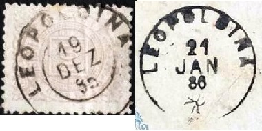
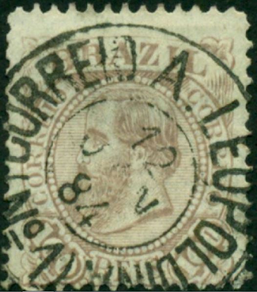
Then came LMG-1495c (fig. F. Piccinini/ José L. Fevereiro), which possibly occurs in variants:
LMG-1495c (FP-JLF) 1884-1889
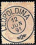
Towards the end of the Empire, the well-known LMG-1495d (fig. from the Internet) also appeared:
LMG-1495d (EB) 1887-1900ff
In July 1887, a railway station of the E.F. Leopoldina railway company (Leopoldina branch) was opened here. Although the post office was not relocated to the station, two railway postmarks were used along the route:
LMG-1496a (EB) 1882-1898, also in blueLMG-1496b (RK) 1882-1898
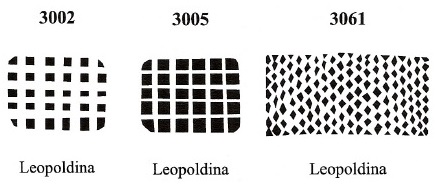
Finally, James Dingler and Klerman W. Lopes have listed seven mute postmarks from Leopoldina in Mute Cancellations of the Brazil Empire / Carimbos Mudos do Brasil Império (Brazil Philatelic Association, Rio de Janeiro, 2000):
BPA 1184 – 1252 (1882) – 1314 – 2998BPA 3002 (P.A. 299) – 3005 – 3061Atlas do Imperio do Brasil, 1868
Andere Namen: Feijão Cru
Ursprünglich hieß der Ort Distrito de S. Sebastião do Feijão Cru (Rohe Bohnen), gehörte zu Vila de Mar d’Hespanha und lag 250 km südöstlich der Provinzhauptstadt Ouro Preto. Im April 1854 wurde er gleichzeitig Vila und Freguesia de Leopoldina. Seit Oktober 1861 ist Leopoldina eine Stadt.
Für die Gründung des örtlichen Postamtes wurden zwei Daten gefunden. Zuerst im März 1857, wie Nova Monteiro in Administrações e Agencias Postaes do Brasil Imperio (Brasil Filatelico/RJ, 1934-5; Reprint SPP 1994-1999) schreibt. Dann 6 Monate später, wie aus História Postal de Minas Gerais (Belo Horizonte, 1997) von Paula Sobrinho hervorgeht.
Von dem ältesten Stempel LMG-1495a haben wir leider nur eine Beschreibung von R. Koester in Carimbologia XXVI. Ein grünblauer Doppelkreis auf einer D. Pedro-Ausgabe von 1866 mit der Inschrift Cidade LEOPOLDINA zwischen den Kreisen und MINAS in der Mitte.
Es folgte der schöne LMG-1495b, der von P. Ayres in Catálogo de Carimbos Brasil-Império (S. Paulo, 1937, 1942) die Nr. 1339 erhielt:
LMG-1495b (P.A. 1339) 1866ff-1873
Danach kam LMG-1495c (Abb. F. Piccinini/ José L. Fevereiro), der evtl. In Varianten vorkommt:
LMG-1495c (FP-JLF) 1884-1889
Gegen Ende des Kaiserreichs erschien auch der bekannte LMG-1495d (Abb. aus dem Internet):
LMG-1495d (EB) 1887-1900ff
Im Juli 1887 wurde hier ein Bahnhof der Eisenbahngesellschaft E.F. Leopoldina (Leopoldina-Zweig) eröffnet. Obwohl das Postamt nicht in den Bahnhof verlegt wurde, wurden entlang der Strecke zwei Bahnpoststempel verwendet:
LMG-1496a (EB) 1882-1898, auch in blauLMG-1496b (RK) 1882-1898
Dann haben James Dingler und Klerman W. Lopes sieben stumme Poststempel aus Leopoldina in Mute Cancellations of the Brazil Empire / Carimbos Mudos do Brasil Império (Brazil Philatelic Association, Rio de Janeiro, 2000) aufgeführt:
Carta da Republica dos Estados Unidos do Brasil, 1892
Other names: Santa Leopoldina, Aruanã (1943)
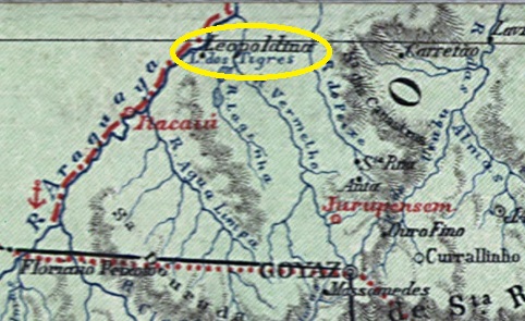
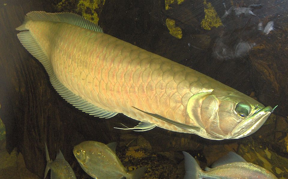
This village had been actually a prison since 1849 and was located on the east bank of the Araguaia, 170 kilometres northwest of the provincial capital Goyaz (today: Goiás Velho). In August 1875, it became the Freguesia de Santa Leopoldina, which belonged to the capital’s Município. In December 1943, the name was changed to Aruanã. Aruanã has been an independent município since December 1958. The Indian name refers to a fish from the Osteoglossidae family:
Osteoglossum bicirrhosum, Cuvier 1829 (Photo: Qwertzy2, CC BY-SA 3.0)
The list of imperial post offices (Tabella das Agencias do Correio do Imperio, Rio de Janeiro, 1885) shows that there has been a post office there since 1870. The oldest postmark to date is LGO-0100b (fig. R. Koester in Carimbologia XXVI):
LGO-0100b (RK) 1890
This was followed by LGO-0100c (fig. Koester, op. cit.):
LGO-0100c (RK) 1890Atlas do Imperio do Brasil, 1868
Andere Namen: Santa Leopoldina, Aruanã (1943)
Diese Ortschaft war seit 1849 ein Gefängnis und lag am Ostufer des Araguaia, 170 km nordwestlich der Provinzhauptstadt Goyaz (heute: Goiás Velho). Im August 1875 wurde es zur Freguesia de Santa Leopoldina, die zum Município der Hauptstadt gehörte. Im Dezember 1943 wurde der Name in Aruanã geändert. Seit Dezember 1958 ist Aruanã ein unabhängiges Município. Der indianische Name bezieht sich auf einen Fisch aus der Familie der Osteoglossidae:
Osteoglossum bicirrhosum, Cuvier 1829 (Foto: Qwertzy2, CC BY-SA 3.0)
Aus dem Verzeichnis der kaiserlichen Postämter (Tabella das Agencias do Correio do Imperio, Rio de Janeiro, 1885) geht hervor, dass es dort seit 1870 ein Postamt gab. Der bisher älteste Poststempel ist LGO-0100b (Abb. R. Koester in Carimbologia XXVI):
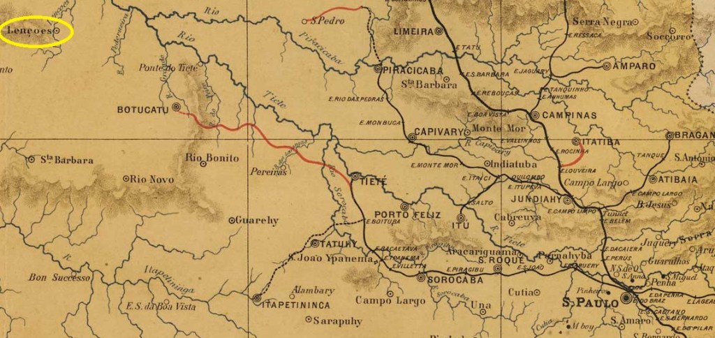
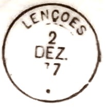
The Freguesia de N. Sra. da Piedade dos Lençóes, in existence since April 1858, belonged to the Vila de Botucatu and was located on the south bank of the Lençóis (a tributary of the Tietê), 280 kilometres northwest of the provincial capital of São Paulo. In April 1865 it became a Vila and in December 1895 a city, which has since changed its name twice: in November 1944 to Ubirama and in December 1948 to Lençóis Paulista.
As Nova Monteiro writes in Administrações e Agencias Postaes do Brasil Imperio (Brasil Filatelico/RJ, 1934-5; reprint SPP 1994-1999), there had been a post office there since April 1866. The oldest postmark to date is the French type LSP-0760b (collect. Fuad Ferreira Fo.):
LSP-0760b (FF) 1876ff-1877
It was followed by LSP-0760c (coll. José A. Junges):
LSP-0760c (JJ) 1886-1888Atlas do Imperio do Brasil, 1868
Andere Namen: Ubirama, Lençóis Paulista (1948)
Die seit April 1858 bestehende Freguesia de N. Sra. da Piedade dos Lençóes gehörte zur Vila de Botucatu und lag am Südufer des Lençóis (einem Nebenfluss des Tietê), 280 km nordwestlich der Provinzhauptstadt São Paulo. Im April 1865 wurde es zur Vila und im Dezember 1895 zur Stadt erhoben, die seitdem zweimal ihren Namen geändert hat: im November 1944 in Ubirama und im Dezember 1948 in Lençóis Paulista.
Wie Nova Monteiro in Administrações e Agencias Postaes do Brasil Imperio (Brasil Filatelico/RJ, 1934-5; Reprint SPP 1994-1999) schreibt, gab es dort seit April 1866 ein Postamt. Der bisher älteste Poststempel ist der französische Typ LSP-0760b (Samml. Fuad Ferreira Fo.):
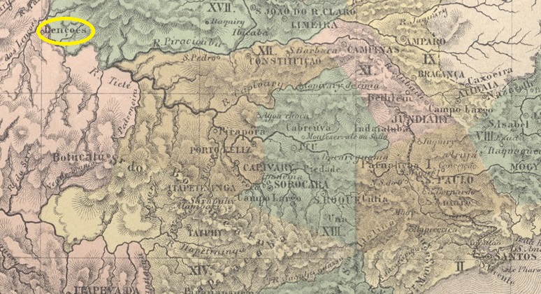
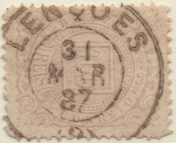
Other names: Lençóes do Roncador, Villa dos Lençóes, Lençóis
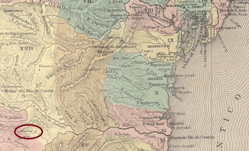
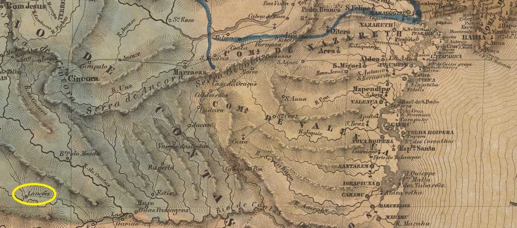
Lençóes had been since 1844 a settlement of the Vila de Minas do Rio de Contas on the south bank of the Riacho S. João (today: Rio Lençóis), 420 kilometres west of the provincial capital Salvador da Bahia. In 1847 it was transferred to the newly founded Vila de Sta. Isabel do Paraguaçu. Three name changes followed: in May 1852 to Distrito de Lençóes do Roncador, in December 1856 to Commercial Villa de Lençóes and in May 1864 to the town N. Sra. da Conceição dos Lençóes.
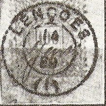
R. Koester writes in Carimbologia XXVI that there had been a post office there since November 1857. The only imperial postmark so far is LBA-0445b (fig. Koester, op.cit.):
LBA-0445b (RK) 1884-1889Villiers de l’Ile Adam: Carta (…) da Provincia da Bahia, 1848
Andere Namen: Lençóes do Roncador, Villa dos Lençóes, Lençóis
Lençóes war seit 1844 eine Siedlung der Vila de Minas do Rio de Contas am Südufer des Riacho S. João (heute: Rio Lençóis), 420 km westlich der Provinzhauptstadt Salvador da Bahia. 1847 wechselte sie zur neu gegründeten Vila de Sta. Isabel do Paraguaçu. Es folgten drei Namensänderungen: im Mai 1852 in Distrito de Lençóes do Roncador, im Dezember 1856 in Commercial Villa de Lençóes und im Mai 1864 in Stadt N. Sra. da Conceição dos Lençóes.
R. Koester schreibt in Carimbologia XXVI, dass es dort seit November 1857 ein Postamt gab. Der bisher einzige kaiserliche Poststempel ist LBA-0445b (Abb. Koester, op.cit.):